


OpenDroneMap
@opendronemap.bsky.social
The first project that we're funding through the Headwaters Project will upgrade OpenMVS with an improved texturing method, replacing MVS-Texturing.
It's a win-win-win: upstream support for a core dependency, improved algorithms in that library, and reduced memory bottlenecks in OpenDroneMap.
It's a win-win-win: upstream support for a core dependency, improved algorithms in that library, and reduced memory bottlenecks in OpenDroneMap.
November 3, 2025 at 9:38 PM
The first project that we're funding through the Headwaters Project will upgrade OpenMVS with an improved texturing method, replacing MVS-Texturing.
It's a win-win-win: upstream support for a core dependency, improved algorithms in that library, and reduced memory bottlenecks in OpenDroneMap.
It's a win-win-win: upstream support for a core dependency, improved algorithms in that library, and reduced memory bottlenecks in OpenDroneMap.
As we build out the new website, our designer added a section that will link on to Industry and Application for OpenDroneMap data.
What would you put for Industry and Application?
What would you put for Industry and Application?

October 3, 2025 at 11:24 PM
As we build out the new website, our designer added a section that will link on to Industry and Application for OpenDroneMap data.
What would you put for Industry and Application?
What would you put for Industry and Application?
Reposted by OpenDroneMap
🤔
We’re collecting cool datasets to show on OpenDroneMap.org, but it also might be useful to have a sentence from you on how you use OpenDroneMap and how it has effected you in your industry.
How has OpenDroneMap changed / improved / supported what you do in your sector?
🤔
We’re collecting cool datasets to show on OpenDroneMap.org, but it also might be useful to have a sentence from you on how you use OpenDroneMap and how it has effected you in your industry.
How has OpenDroneMap changed / improved / supported what you do in your sector?
🤔

Drone Mapping Software - OpenDroneMap™
Drone mapping software. Generate maps, point clouds, 3D models and DEMs from images, any orientation, any camera.
OpenDroneMap.org
August 22, 2025 at 11:24 PM
🤔
We’re collecting cool datasets to show on OpenDroneMap.org, but it also might be useful to have a sentence from you on how you use OpenDroneMap and how it has effected you in your industry.
How has OpenDroneMap changed / improved / supported what you do in your sector?
🤔
We’re collecting cool datasets to show on OpenDroneMap.org, but it also might be useful to have a sentence from you on how you use OpenDroneMap and how it has effected you in your industry.
How has OpenDroneMap changed / improved / supported what you do in your sector?
🤔
Reposted by OpenDroneMap


Reposted by OpenDroneMap

Sometimes stuff is just bananas. www.youtube.com/watch?v=1bma...

September 15, 2025 at 9:32 PM
Sometimes stuff is just bananas. www.youtube.com/watch?v=1bma...
Following up on the prior request for cool datasets: whether for posting on the website or just showing off for fun, what cool elevation datasets are folks rocking these days? Anything to show off?
We've got some cool things already posted here:
community.opendronemap.org/t/cool-datas...
We've got some cool things already posted here:
community.opendronemap.org/t/cool-datas...

September 9, 2025 at 10:55 PM
Following up on the prior request for cool datasets: whether for posting on the website or just showing off for fun, what cool elevation datasets are folks rocking these days? Anything to show off?
We've got some cool things already posted here:
community.opendronemap.org/t/cool-datas...
We've got some cool things already posted here:
community.opendronemap.org/t/cool-datas...
Reposted by OpenDroneMap
We're working on an updated OpenDroneMap website and we want to showcase datasets from OpenDroneMap enthusiasts there.
You’ll be credited on the website, your cool work shown off, and we’ll be able to highlight the cool stuff that OpenDroneMap can do!
community.opendronemap.org/t/cool-datas...
You’ll be credited on the website, your cool work shown off, and we’ll be able to highlight the cool stuff that OpenDroneMap can do!
community.opendronemap.org/t/cool-datas...

August 15, 2025 at 11:24 PM
We're working on an updated OpenDroneMap website and we want to showcase datasets from OpenDroneMap enthusiasts there.
You’ll be credited on the website, your cool work shown off, and we’ll be able to highlight the cool stuff that OpenDroneMap can do!
community.opendronemap.org/t/cool-datas...
You’ll be credited on the website, your cool work shown off, and we’ll be able to highlight the cool stuff that OpenDroneMap can do!
community.opendronemap.org/t/cool-datas...
🤔
We’re collecting cool datasets to show on OpenDroneMap.org, but it also might be useful to have a sentence from you on how you use OpenDroneMap and how it has effected you in your industry.
How has OpenDroneMap changed / improved / supported what you do in your sector?
🤔
We’re collecting cool datasets to show on OpenDroneMap.org, but it also might be useful to have a sentence from you on how you use OpenDroneMap and how it has effected you in your industry.
How has OpenDroneMap changed / improved / supported what you do in your sector?
🤔
Drone Mapping Software - OpenDroneMap™
Drone mapping software. Generate maps, point clouds, 3D models and DEMs from images, any orientation, any camera.
OpenDroneMap.org
August 22, 2025 at 11:24 PM
🤔
We’re collecting cool datasets to show on OpenDroneMap.org, but it also might be useful to have a sentence from you on how you use OpenDroneMap and how it has effected you in your industry.
How has OpenDroneMap changed / improved / supported what you do in your sector?
🤔
We’re collecting cool datasets to show on OpenDroneMap.org, but it also might be useful to have a sentence from you on how you use OpenDroneMap and how it has effected you in your industry.
How has OpenDroneMap changed / improved / supported what you do in your sector?
🤔
Reposted by OpenDroneMap

Got questions about drones? Questions like “can I legally take down a drone with a flaming arrow, or a trained eagle that’s also on fire?”
I answer most of them here!
little-flying-robots.ghost.io/i-answer-som...
I answer most of them here!
little-flying-robots.ghost.io/i-answer-som...

I Answer Some Of Your Burning Drone Questions
Whenever drones pop up in the news, whenever they buzz unnervingly again into popular perception, people ask me what I think about these latest developments on social media. Most of the time, and rega...
little-flying-robots.ghost.io
August 21, 2025 at 2:55 PM
Got questions about drones? Questions like “can I legally take down a drone with a flaming arrow, or a trained eagle that’s also on fire?”
I answer most of them here!
little-flying-robots.ghost.io/i-answer-som...
I answer most of them here!
little-flying-robots.ghost.io/i-answer-som...
We're working on an updated OpenDroneMap website and we want to showcase datasets from OpenDroneMap enthusiasts there.
You’ll be credited on the website, your cool work shown off, and we’ll be able to highlight the cool stuff that OpenDroneMap can do!
community.opendronemap.org/t/cool-datas...
You’ll be credited on the website, your cool work shown off, and we’ll be able to highlight the cool stuff that OpenDroneMap can do!
community.opendronemap.org/t/cool-datas...
August 15, 2025 at 11:24 PM
We're working on an updated OpenDroneMap website and we want to showcase datasets from OpenDroneMap enthusiasts there.
You’ll be credited on the website, your cool work shown off, and we’ll be able to highlight the cool stuff that OpenDroneMap can do!
community.opendronemap.org/t/cool-datas...
You’ll be credited on the website, your cool work shown off, and we’ll be able to highlight the cool stuff that OpenDroneMap can do!
community.opendronemap.org/t/cool-datas...
Reposted by OpenDroneMap

One thing maybe not discussed enough is the long term opportunity cost of not investing and supporting open source software. Imagine the more and better Blenders, GIMPs, Firefoxs, InkScapes, QGISs etc we would of had (+ could have) if open source was taken more seriously by government and businesses
February 23, 2025 at 8:19 PM
One thing maybe not discussed enough is the long term opportunity cost of not investing and supporting open source software. Imagine the more and better Blenders, GIMPs, Firefoxs, InkScapes, QGISs etc we would of had (+ could have) if open source was taken more seriously by government and businesses
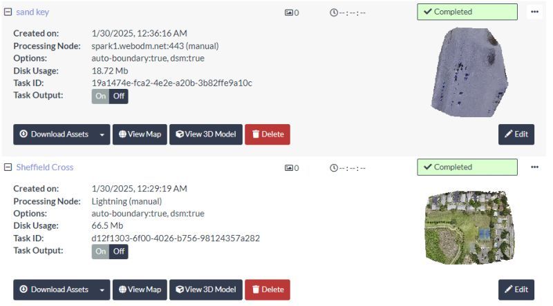
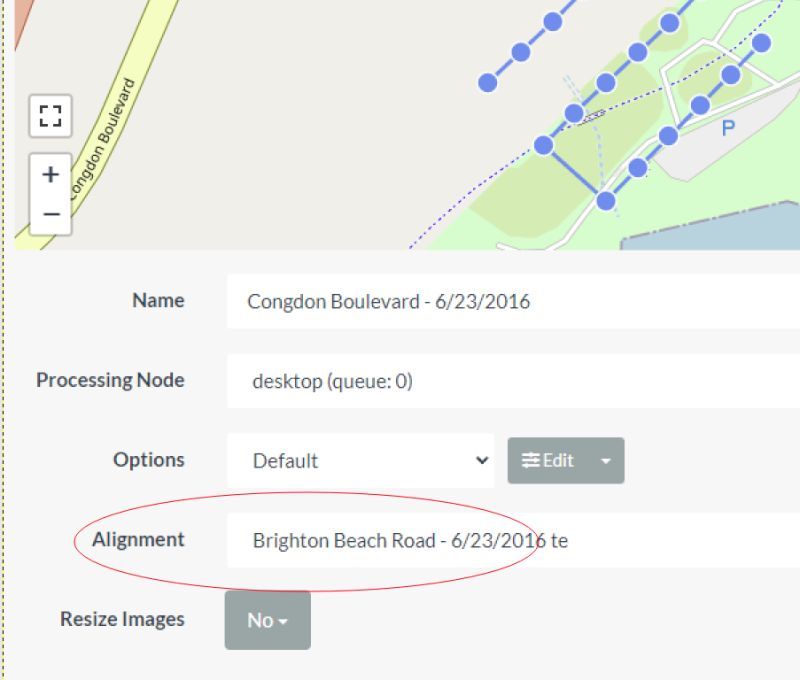
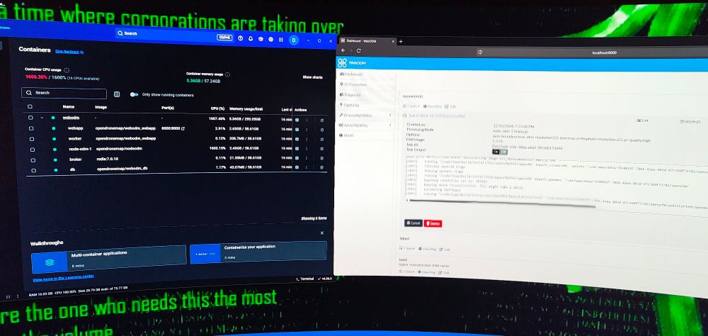
Continuing the heavy hits on WebODM updates. This list looks short, but it's substantive:
OpenDroneMap/WebODM
V2.7.1
---
- Geolocation file download
- Task thumbnails
- Task alignment support
OpenDroneMap/WebODM
V2.7.1
---
- Geolocation file download
- Task thumbnails
- Task alignment support
February 21, 2025 at 10:32 PM
Continuing the heavy hits on WebODM updates. This list looks short, but it's substantive:
OpenDroneMap/WebODM
V2.7.1
---
- Geolocation file download
- Task thumbnails
- Task alignment support
OpenDroneMap/WebODM
V2.7.1
---
- Geolocation file download
- Task thumbnails
- Task alignment support
Reposted by OpenDroneMap

This is wonderful! Leymus mollis is California's native beach grass. Introduced European beach grass that was there makes a very different dune structure. The native grass builds lower slope dunes leaving space for foredune plants while the non-native builds steep slopes & less plant diversity.
Here are a couple photos from yesterday’s last minute transplanting of our native Leymus mollis dune grass down on Ocean Beach! Next opportunity is this Saturday! x.gldn.io/e/RmwwQ6fG7Qb
#CaliforniaNativePlants #SurfriderSF #OceanBeachPark
#CaliforniaNativePlants #SurfriderSF #OceanBeachPark


February 20, 2025 at 11:43 PM
This is wonderful! Leymus mollis is California's native beach grass. Introduced European beach grass that was there makes a very different dune structure. The native grass builds lower slope dunes leaving space for foredune plants while the non-native builds steep slopes & less plant diversity.
OpenDroneMap/WebODM
V2.7.0
---
New Feature:
- Simultaneous map items display and swipe view
Bug fixes:
- Fix contours, objdetect plugins
- Handle PIL decompression bomb error
---
#OpenDroneMap #WebODM #ODMUpdatesBot
github.com/OpenDroneMap...
V2.7.0
---
New Feature:
- Simultaneous map items display and swipe view
Bug fixes:
- Fix contours, objdetect plugins
- Handle PIL decompression bomb error
---
#OpenDroneMap #WebODM #ODMUpdatesBot
github.com/OpenDroneMap...
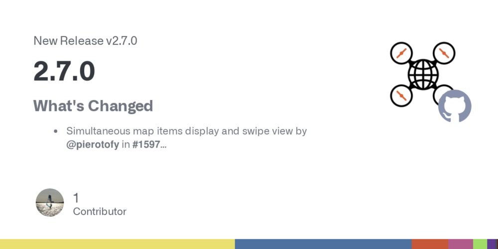
Release 2.7.0 · OpenDroneMap/WebODM
What's Changed
Simultaneous map items display and swipe view by @pierotofy in #1597
Fix contours, objdetect plugins by @pierotofy in #1604
Handle PIL decompression bomb error by @pierotofy in #160...
github.com
February 18, 2025 at 4:43 PM
OpenDroneMap/WebODM
V2.7.0
---
New Feature:
- Simultaneous map items display and swipe view
Bug fixes:
- Fix contours, objdetect plugins
- Handle PIL decompression bomb error
---
#OpenDroneMap #WebODM #ODMUpdatesBot
github.com/OpenDroneMap...
V2.7.0
---
New Feature:
- Simultaneous map items display and swipe view
Bug fixes:
- Fix contours, objdetect plugins
- Handle PIL decompression bomb error
---
#OpenDroneMap #WebODM #ODMUpdatesBot
github.com/OpenDroneMap...
So what's GeoDeep? Just a bit of object detection and segmentation:


February 12, 2025 at 9:48 PM
So what's GeoDeep? Just a bit of object detection and segmentation:
We've got some consequential new updates in WebODM, with object detection now built in.
This also launches a new utility (GeoDeep).
OpenDroneMap/WebODM
V2.6.0
github.com/OpenDroneMap...
This also launches a new utility (GeoDeep).
OpenDroneMap/WebODM
V2.6.0
github.com/OpenDroneMap...
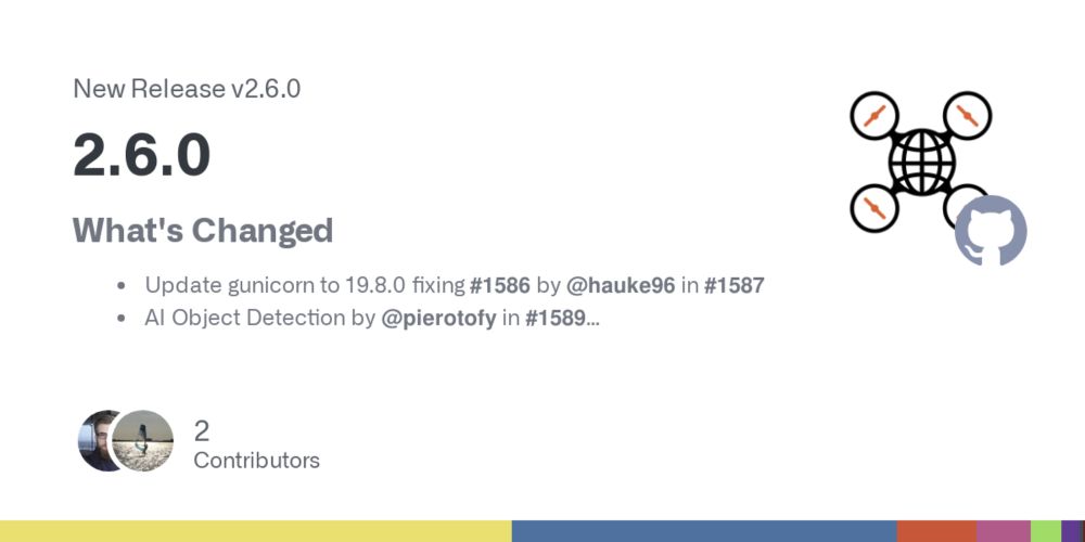
Release 2.6.0 · OpenDroneMap/WebODM
What's Changed
Update gunicorn to 19.8.0 fixing #1586 by @hauke96 in #1587
AI Object Detection by @pierotofy in #1589
Add point cloud resampling export by @pierotofy in #1590
Add worker max thread...
github.com
February 12, 2025 at 9:38 PM
We've got some consequential new updates in WebODM, with object detection now built in.
This also launches a new utility (GeoDeep).
OpenDroneMap/WebODM
V2.6.0
github.com/OpenDroneMap...
This also launches a new utility (GeoDeep).
OpenDroneMap/WebODM
V2.6.0
github.com/OpenDroneMap...
Reposted by OpenDroneMap
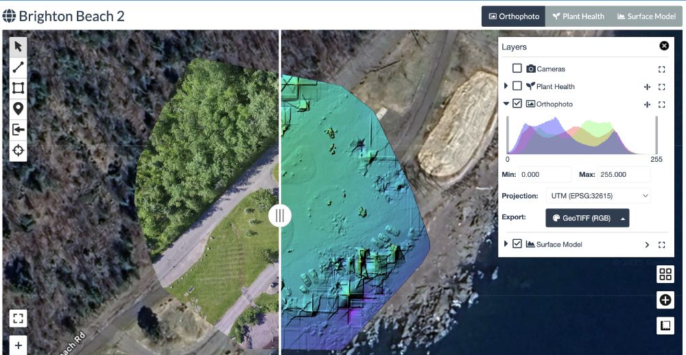
This one took a while, but finally found the time. Compare layers in WebODM (works also across tasks). github.com/OpenDroneMap... Time to update!
February 12, 2025 at 6:00 PM
This one took a while, but finally found the time. Compare layers in WebODM (works also across tasks). github.com/OpenDroneMap... Time to update!
Reposted by OpenDroneMap

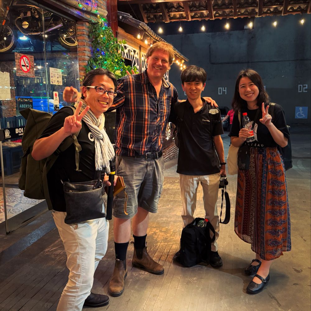
FOSS4G Workshop Day2 おつかれシュラスコを食べに、地元の領事館おすすめシュハスカリアにやってきました。OpenDroneMapのIvanとArcEdge Space鈴本さん、PLATEAUの十川さん、増田さん、古橋のドローン・地球観測衛星・3D都市デジタルツインテーマにさまざまな技術的方向性を意見交換。
#OpenDroneMap #ArcEdgeSpace #PLATEAU #DRONEBIRD #Brasil #Belem #FOSS4G #sotmlatam #FuruhashiLab #古橋研究室 #AoyamaGSC #地球社会共生学部 #青学 #一億総伊能化
#OpenDroneMap #ArcEdgeSpace #PLATEAU #DRONEBIRD #Brasil #Belem #FOSS4G #sotmlatam #FuruhashiLab #古橋研究室 #AoyamaGSC #地球社会共生学部 #青学 #一億総伊能化
December 4, 2024 at 9:51 AM
FOSS4G Workshop Day2 おつかれシュラスコを食べに、地元の領事館おすすめシュハスカリアにやってきました。OpenDroneMapのIvanとArcEdge Space鈴本さん、PLATEAUの十川さん、増田さん、古橋のドローン・地球観測衛星・3D都市デジタルツインテーマにさまざまな技術的方向性を意見交換。
#OpenDroneMap #ArcEdgeSpace #PLATEAU #DRONEBIRD #Brasil #Belem #FOSS4G #sotmlatam #FuruhashiLab #古橋研究室 #AoyamaGSC #地球社会共生学部 #青学 #一億総伊能化
#OpenDroneMap #ArcEdgeSpace #PLATEAU #DRONEBIRD #Brasil #Belem #FOSS4G #sotmlatam #FuruhashiLab #古橋研究室 #AoyamaGSC #地球社会共生学部 #青学 #一億総伊能化
Reposted by OpenDroneMap

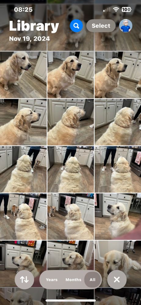
I have been trying to build a 3D model using OpenDroneMap and am looking for guidance how to capture a moving object. I used a Canon D3300 with a constant focal length because my iPhone camera did not work well. #goldens #opendronemap #photogrammetry
December 7, 2024 at 1:32 PM
I have been trying to build a 3D model using OpenDroneMap and am looking for guidance how to capture a moving object. I used a Canon D3300 with a constant focal length because my iPhone camera did not work well. #goldens #opendronemap #photogrammetry
Reposted by OpenDroneMap
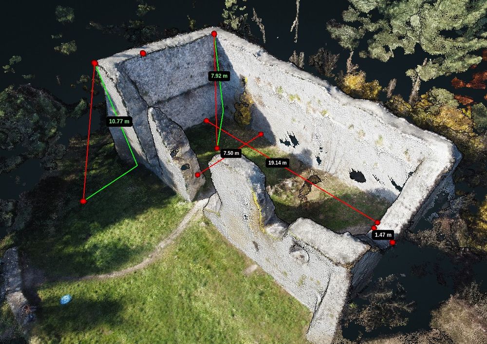
Bydliński zamek to wdzięczny obiekt do ćwiczeń z obsługi #OpenDroneMap #WebODM - obsługa wirtualnej taśmy mierniczej to cenna umiejętność. Ilustracji do podręcznika ciąg dalszy ;)
November 20, 2024 at 9:22 AM
Bydliński zamek to wdzięczny obiekt do ćwiczeń z obsługi #OpenDroneMap #WebODM - obsługa wirtualnej taśmy mierniczej to cenna umiejętność. Ilustracji do podręcznika ciąg dalszy ;)
Reposted by OpenDroneMap

This part 3 of a 3 part series of great tutorials/demonstration showing how much you can do with a drone, a bit of land, and a bunch of free open-source software: QGIS and OpenDroneMap in this case
#ODM #GIS #UAV #QGIS
www.spatialised.net/mapping-a-sm...
#ODM #GIS #UAV #QGIS
www.spatialised.net/mapping-a-sm...
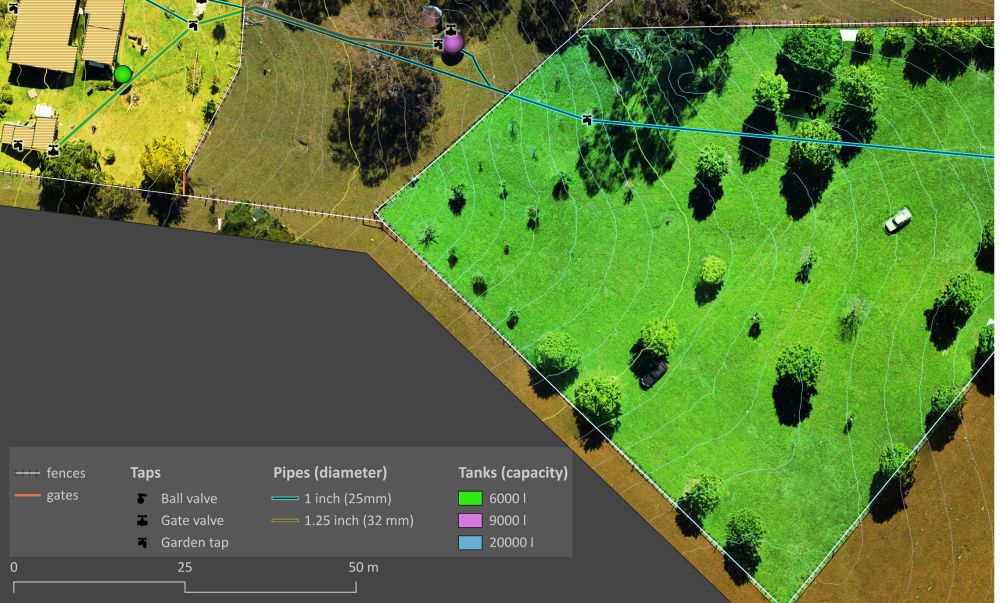
Mapping a small farm part 3: using an aerial orthophoto
Part 1 of this series looked at how to fly drones and collect imagery for mapping over a small property. Part 2 showed use cases for a digital elevation model. This story focusses on the georeferen…
www.spatialised.net
July 19, 2024 at 11:48 AM
This part 3 of a 3 part series of great tutorials/demonstration showing how much you can do with a drone, a bit of land, and a bunch of free open-source software: QGIS and OpenDroneMap in this case
#ODM #GIS #UAV #QGIS
www.spatialised.net/mapping-a-sm...
#ODM #GIS #UAV #QGIS
www.spatialised.net/mapping-a-sm...
Reposted by OpenDroneMap
December 17, 2024 at 6:06 PM
<tap><tap> Is thing thing on?
December 18, 2024 at 6:50 PM
<tap><tap> Is thing thing on?