James Williamson, Labrador GIS Specialist
banner
northernmaps.bsky.social
James Williamson, Labrador GIS Specialist
@northernmaps.bsky.social
100 followers 550 following 20 posts
(He/Him) I am a GIS Specialist, working from Happy Valley-Goose Bay. I love maps, cartography and cool data visualisations. Currently finishing a PhD with MUNL on the historic landscape of the Exploits River Valley.
Posts Media Videos Starter Packs
Reposted by James Williamson, Labrador GIS Specialist
🌈 rainbowR meet-up: Wednesday August 27th, 4pm UTC 🌈

- connect with other LGBTQ+ people who code in #RStats 🏳️‍🌈
- ask questions about R 🙋
- tell us about an R package you like 📦
- show us something R-related you’ve been working on 💻

➡️ Registration via rainbowr.org/meetups
A distribution map of the known archaeological sites on the island of Newfoundland. It shows how archaeological research has focused on the heavily populated coast, away from the boreal interior.
Reposted by James Williamson, Labrador GIS Specialist
A Relative Elevation map for the Churchill River. This is interesting because it shows how the river runs through a rugged area between two different relatively low areas, while going from the Smallwood Reservoir to the shores of Lake Melville.
#Labrador #HVGB #qgis #maps #REM
Reposted by James Williamson, Labrador GIS Specialist

The healthiest thing we can do for the internet is get as many regular users as possible running their own websites. You could buy a domain and such, but a super easy starting point is to get a free subdomain of neocities.org, which is like geocities but existing now.
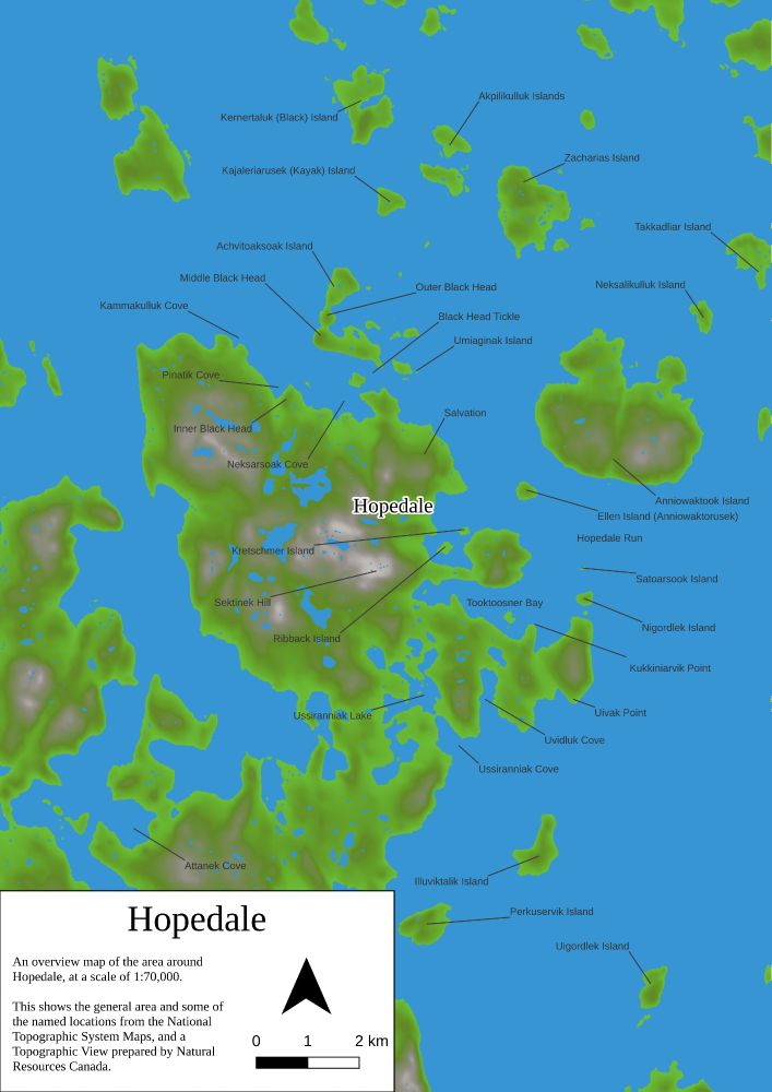
A Tanaka map of the topography around Hopedale, Nunatsiavut, Labrador.
data: NRCAN- NTS

#qgis #maps #topography #visualisation #3d #gis #Nunatsiavut #Labrador
Reposted by James Williamson, Labrador GIS Specialist
Another Photo of Hopedale, Nunatsiavut, Labrador, from a few years ago.

#drones #Hopedale #Nunatsiavut #geospatial
A joy plot view of Hopedale, Nunatsiavut, Labrador. With data from the Canadian MRDEM.
The watercourses of Newfoundland

with data from NRCAN and the NTS

#gis #qgis #spatial #rivers #maps
The Rivers of Labrador. It's pretty thick with them.

Data from the NTS

#maps #Labrador #QGIS #spatial #gis #nrcan #nts
A map of the Hexagonal churches of England, prepared for the Month of Maps in 2024.

#England #churches #hexagons #gis #qgis #geospatial #maps
A map of the National Parks of Canada, with data from NRCAN and Natural Earth.
There is an amazing variation between the parks, in terms of their sizes and purposes.

#parks #canada #maps #geospatial #gis #qgis
The roads, trails, ferries and transport paths (and some boundaries) of Auckland, New Zealand in a lightening map.

#qgis #geospatial #osm #gis
A map of the Mexican Restaurants of North America, with data from OSM and Natural Earth.

Really, I made this because I miss burritos soo much.

#OSM
#QGIS
#NaturalEarth
#MexicanRestaurants
The watersheds of Labrador from NRCAN and Natural Earth data.
A geological age map of Newfoundland and Labrador. The data used here came from the Department of Natural Resources NL, Natural Earth, and NRCAN
First post! A topographic relief map of Labrador.