


Map Myths
@mapmyths.com
Map Myths delves into the stories and people behind the phantom geography found on maps - by @rhewlif.xyz
Myth map 👉 https://mapmyths.com
Long reads 👉 https://mapmyths.com/blog
Myth map 👉 https://mapmyths.com
Long reads 👉 https://mapmyths.com/blog
📣 New blog post
The resurrection of a fake letter in the mid-18th century stoked international geopolitical tensions at a time when the individual reward for discovering the Northwest Passage was worth over £2 million.
The resurrection of a fake letter in the mid-18th century stoked international geopolitical tensions at a time when the individual reward for discovering the Northwest Passage was worth over £2 million.

The 18th-century English fake news that helped spawn an American sea
This is a story of how one piece of flawed journalism published in London snowballed a myth that defined the geography of northwest America on over 200 historic
mapmyths.com
November 16, 2025 at 6:16 PM
📣 New blog post
The resurrection of a fake letter in the mid-18th century stoked international geopolitical tensions at a time when the individual reward for discovering the Northwest Passage was worth over £2 million.
The resurrection of a fake letter in the mid-18th century stoked international geopolitical tensions at a time when the individual reward for discovering the Northwest Passage was worth over £2 million.
In November 1828, in the rough seas near Cape Horn, Thomas Burdwood of the British transport ship Kains discovered a small rocky island.
Like most captains would, he named it Burdwood Island after himself.
Like most captains would, he named it Burdwood Island after himself.
November 14, 2025 at 9:49 PM
In November 1828, in the rough seas near Cape Horn, Thomas Burdwood of the British transport ship Kains discovered a small rocky island.
Like most captains would, he named it Burdwood Island after himself.
Like most captains would, he named it Burdwood Island after himself.
In 1617, Joris Carolus was commissioned by the Noordsche Compagnie - a Dutch whaling cartel - to lead a voyage of discovery.
The mission was apparently successful, with the discovery of two new islands. The first he named Nyeu Hollandt, while the other he named Opdams Eylandt.
The mission was apparently successful, with the discovery of two new islands. The first he named Nyeu Hollandt, while the other he named Opdams Eylandt.

November 6, 2025 at 10:01 PM
In 1617, Joris Carolus was commissioned by the Noordsche Compagnie - a Dutch whaling cartel - to lead a voyage of discovery.
The mission was apparently successful, with the discovery of two new islands. The first he named Nyeu Hollandt, while the other he named Opdams Eylandt.
The mission was apparently successful, with the discovery of two new islands. The first he named Nyeu Hollandt, while the other he named Opdams Eylandt.
The 'Binchichins' is a story of how one Scottish mountain became an entire mountain range, before disappearing from maps entirely.
During the early 17th century, the original Gaelic name used for the mountain recognised today as Lochnagar was Beinn nan Chìochan (the hill of the paps/breasts).
During the early 17th century, the original Gaelic name used for the mountain recognised today as Lochnagar was Beinn nan Chìochan (the hill of the paps/breasts).

October 24, 2025 at 8:39 AM
The 'Binchichins' is a story of how one Scottish mountain became an entire mountain range, before disappearing from maps entirely.
During the early 17th century, the original Gaelic name used for the mountain recognised today as Lochnagar was Beinn nan Chìochan (the hill of the paps/breasts).
During the early 17th century, the original Gaelic name used for the mountain recognised today as Lochnagar was Beinn nan Chìochan (the hill of the paps/breasts).
📣 NEW BLOG POST
Did German pirates beat Columbus to America?
Sometime in the 1470s, King Christian I of Denmark hired two German privateers "at the request of his majesty of Portugal...to explore new countries and islands in the north".
Did German pirates beat Columbus to America?
Sometime in the 1470s, King Christian I of Denmark hired two German privateers "at the request of his majesty of Portugal...to explore new countries and islands in the north".

October 19, 2025 at 1:28 PM
📣 NEW BLOG POST
Did German pirates beat Columbus to America?
Sometime in the 1470s, King Christian I of Denmark hired two German privateers "at the request of his majesty of Portugal...to explore new countries and islands in the north".
Did German pirates beat Columbus to America?
Sometime in the 1470s, King Christian I of Denmark hired two German privateers "at the request of his majesty of Portugal...to explore new countries and islands in the north".
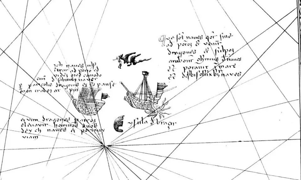
Always remember to first check that the island you've just anchored to isn't a giant whale before lighting your evening fire.
For more sailing advice and sea monsters from the Nordic seas join me on a short tour around Olaus Magnus' 1539 Carta Marina.
For more sailing advice and sea monsters from the Nordic seas join me on a short tour around Olaus Magnus' 1539 Carta Marina.

The map of man-eating monsters
YouTube video by Map Myths
youtube.com
October 14, 2025 at 7:59 PM
Always remember to first check that the island you've just anchored to isn't a giant whale before lighting your evening fire.
For more sailing advice and sea monsters from the Nordic seas join me on a short tour around Olaus Magnus' 1539 Carta Marina.
For more sailing advice and sea monsters from the Nordic seas join me on a short tour around Olaus Magnus' 1539 Carta Marina.
No map is safe from a cat's curiosity!
Ultraviolet photography of this 17th-century Japanese map of Nagasaki has revealed the unsuspected paw prints of a cat.
Ultraviolet photography of this 17th-century Japanese map of Nagasaki has revealed the unsuspected paw prints of a cat.
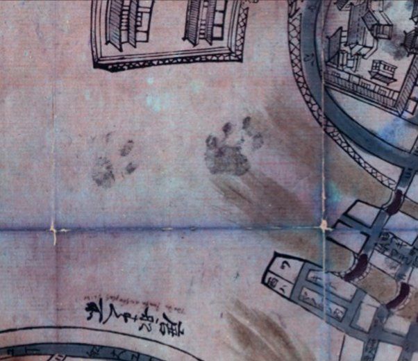
![Map: Nagasaki ezu [長崎絵図], 1680-1688. A large-scale pictorial map of the port of Nagasaki, hand-coloured, with sketches of Dutch and Chinese ships, showing also the island of Deshima. Panels at bottom left show Chinese, Dutch and other foreigners in costume, and two tables giving distances in ri of foreign ports from Japan and details of the town of Nagasaki. Source: British Library](https://cdn.bsky.app/img/feed_thumbnail/plain/did:plc:gohbwk2wlwrjiqejxg3femmz/bafkreicguuhkpniw73yb2mqgtlbjozr77xqftpilgcwfymfs6w2rm6qdxu@jpeg)
October 13, 2025 at 4:05 PM
No map is safe from a cat's curiosity!
Ultraviolet photography of this 17th-century Japanese map of Nagasaki has revealed the unsuspected paw prints of a cat.
Ultraviolet photography of this 17th-century Japanese map of Nagasaki has revealed the unsuspected paw prints of a cat.
Reposted by Map Myths
What if the phantom islands of Frisland and Hy Brasil were real? You might get this map from B14hawk. #MapMonday
Source: www.reddit.com/r/imaginarym...
Source: www.reddit.com/r/imaginarym...

September 8, 2025 at 6:15 PM
What if the phantom islands of Frisland and Hy Brasil were real? You might get this map from B14hawk. #MapMonday
Source: www.reddit.com/r/imaginarym...
Source: www.reddit.com/r/imaginarym...
📣 NEW BLOG POST
In the sixteenth century, enormous man-eating monsters ruled the oceans. Nowhere else are these fear-inducing creatures better depicted than on the 1539 "Carta Marina" by Olaus Magnus.
In the sixteenth century, enormous man-eating monsters ruled the oceans. Nowhere else are these fear-inducing creatures better depicted than on the 1539 "Carta Marina" by Olaus Magnus.

September 29, 2025 at 4:17 PM
📣 NEW BLOG POST
In the sixteenth century, enormous man-eating monsters ruled the oceans. Nowhere else are these fear-inducing creatures better depicted than on the 1539 "Carta Marina" by Olaus Magnus.
In the sixteenth century, enormous man-eating monsters ruled the oceans. Nowhere else are these fear-inducing creatures better depicted than on the 1539 "Carta Marina" by Olaus Magnus.
While en route to the North Pole on a modern ice-going vessel, glaciologist Henry Patton reveals some of the crazy mapping mistakes and theories of what people used to believe lay hidden in this icy kingdom.
📽️ Editing by @media.elizaveta.no
📽️ Editing by @media.elizaveta.no

Secrets of the North Pole unravelled
YouTube video by Map Myths
youtube.com
September 28, 2025 at 11:39 AM
While en route to the North Pole on a modern ice-going vessel, glaciologist Henry Patton reveals some of the crazy mapping mistakes and theories of what people used to believe lay hidden in this icy kingdom.
📽️ Editing by @media.elizaveta.no
📽️ Editing by @media.elizaveta.no
Like a flat-earth conspiracy theory, Podesta is one phantom island that has refused to die, and has even recently been 'annexed'.
Discovered by the aptly named Captain Pinocchio* in 1879 off the coast of Chile, it was supposedly 1 km in circumference.
*Finocchio, according to some sources
Discovered by the aptly named Captain Pinocchio* in 1879 off the coast of Chile, it was supposedly 1 km in circumference.
*Finocchio, according to some sources

September 23, 2025 at 3:20 PM
Like a flat-earth conspiracy theory, Podesta is one phantom island that has refused to die, and has even recently been 'annexed'.
Discovered by the aptly named Captain Pinocchio* in 1879 off the coast of Chile, it was supposedly 1 km in circumference.
*Finocchio, according to some sources
Discovered by the aptly named Captain Pinocchio* in 1879 off the coast of Chile, it was supposedly 1 km in circumference.
*Finocchio, according to some sources
The 'semblance' of an island, thirty miles long with high peaked mountains, was sighted by C.J. Nockells of the British sealing ship Emerald, in December 1821.

September 12, 2025 at 12:06 PM
The 'semblance' of an island, thirty miles long with high peaked mountains, was sighted by C.J. Nockells of the British sealing ship Emerald, in December 1821.
Mayda, with its many pseudonyms, is one of the most enduring phantom islands of the North Atlantic, though its origin is largely unknown.
Its signature crescent shape first appears in 1367 with the label Brazir, with the more common name of Mayda appearing only later in 1553.
Its signature crescent shape first appears in 1367 with the label Brazir, with the more common name of Mayda appearing only later in 1553.

September 1, 2025 at 1:51 PM
Mayda, with its many pseudonyms, is one of the most enduring phantom islands of the North Atlantic, though its origin is largely unknown.
Its signature crescent shape first appears in 1367 with the label Brazir, with the more common name of Mayda appearing only later in 1553.
Its signature crescent shape first appears in 1367 with the label Brazir, with the more common name of Mayda appearing only later in 1553.
When the 'Vinland Map' was announced to the world in 1965, it turned the known history of transatlantic exploration on its head.
Was the depiction of a landmass southwest of Greenland, clearly labelled "Vinlanda Insula", proof of Viking expansion into the New World centuries before Columbus?
Was the depiction of a landmass southwest of Greenland, clearly labelled "Vinlanda Insula", proof of Viking expansion into the New World centuries before Columbus?

The map that rewrote history…or so we thought
When the discovery of the Vinland Map was announced to the world in 1965, it was presented as a genuine 15th-century mappa mundi , a world map that contained a
mapmyths.com
August 23, 2025 at 1:14 PM
When the 'Vinland Map' was announced to the world in 1965, it turned the known history of transatlantic exploration on its head.
Was the depiction of a landmass southwest of Greenland, clearly labelled "Vinlanda Insula", proof of Viking expansion into the New World centuries before Columbus?
Was the depiction of a landmass southwest of Greenland, clearly labelled "Vinlanda Insula", proof of Viking expansion into the New World centuries before Columbus?
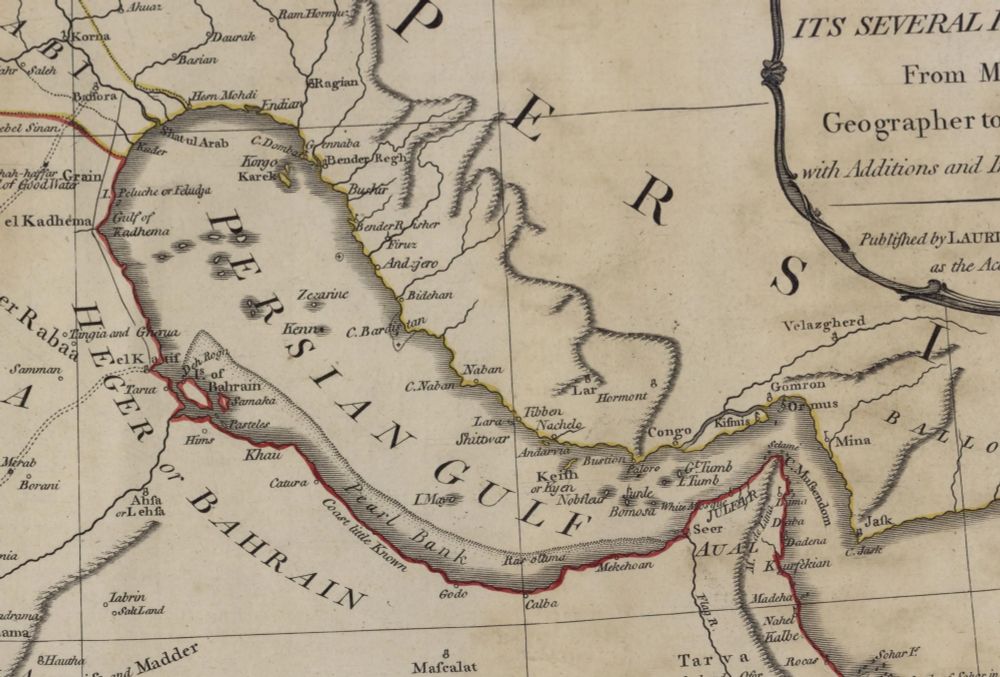
Parts of the Persian Gulf were still a mystery to western geographers during the 18th century, particularly along its western shore.
The most egregious mistakes included the absence of the Qatar Peninsula, seemingly replaced by Samak Island.
📖 mapmyths.com#samak
The most egregious mistakes included the absence of the Qatar Peninsula, seemingly replaced by Samak Island.
📖 mapmyths.com#samak
August 17, 2025 at 7:12 PM
Parts of the Persian Gulf were still a mystery to western geographers during the 18th century, particularly along its western shore.
The most egregious mistakes included the absence of the Qatar Peninsula, seemingly replaced by Samak Island.
📖 mapmyths.com#samak
The most egregious mistakes included the absence of the Qatar Peninsula, seemingly replaced by Samak Island.
📖 mapmyths.com#samak
While fleeing Macau on charges of illegal trading in 1589, João da Gama sighted land northeast of Japan.
His reports were initially added to early Portuguese maps as a series of small islands, but later, 'Gamaland' ballooned in size across the North Pacific.
📖 mapmyths.com#de-gama's-land
His reports were initially added to early Portuguese maps as a series of small islands, but later, 'Gamaland' ballooned in size across the North Pacific.
📖 mapmyths.com#de-gama's-land


August 13, 2025 at 1:05 PM
While fleeing Macau on charges of illegal trading in 1589, João da Gama sighted land northeast of Japan.
His reports were initially added to early Portuguese maps as a series of small islands, but later, 'Gamaland' ballooned in size across the North Pacific.
📖 mapmyths.com#de-gama's-land
His reports were initially added to early Portuguese maps as a series of small islands, but later, 'Gamaland' ballooned in size across the North Pacific.
📖 mapmyths.com#de-gama's-land
Denia and Marseveen first appeared on charts from Joannes van Keulen in 1680, supposedly sighted by Dutch Company ships.
In all likelihood, this pair of islands is probably an early sighting and duplication of Marion and Prince Edward islands, around 1,500 km to the east.
📖 mapmyths.com#marseveen
In all likelihood, this pair of islands is probably an early sighting and duplication of Marion and Prince Edward islands, around 1,500 km to the east.
📖 mapmyths.com#marseveen


August 5, 2025 at 12:50 PM
Denia and Marseveen first appeared on charts from Joannes van Keulen in 1680, supposedly sighted by Dutch Company ships.
In all likelihood, this pair of islands is probably an early sighting and duplication of Marion and Prince Edward islands, around 1,500 km to the east.
📖 mapmyths.com#marseveen
In all likelihood, this pair of islands is probably an early sighting and duplication of Marion and Prince Edward islands, around 1,500 km to the east.
📖 mapmyths.com#marseveen
The South Shetland Islands, the first discovery south of 60°S, were quickly exploited by sealers in the 1820s. Troubled with fog and ice, the charts they produced for the British Admiralty were of varying accuracy.
One phantom that slipped through was Huson's/Middle Island.
One phantom that slipped through was Huson's/Middle Island.


July 22, 2025 at 9:45 AM
The South Shetland Islands, the first discovery south of 60°S, were quickly exploited by sealers in the 1820s. Troubled with fog and ice, the charts they produced for the British Admiralty were of varying accuracy.
One phantom that slipped through was Huson's/Middle Island.
One phantom that slipped through was Huson's/Middle Island.
The first map of Japan in a European atlas appeared in 1595 and curiously also included a carrot-shaped island off the coast of China: 'Corea insula'.
Little was known of the Far East during the 16th century, so Korea's insular nature was largely speculative.
Little was known of the Far East during the 16th century, so Korea's insular nature was largely speculative.

July 17, 2025 at 8:45 AM
The first map of Japan in a European atlas appeared in 1595 and curiously also included a carrot-shaped island off the coast of China: 'Corea insula'.
Little was known of the Far East during the 16th century, so Korea's insular nature was largely speculative.
Little was known of the Far East during the 16th century, so Korea's insular nature was largely speculative.
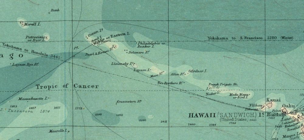
#OTD in 1825, Benjamin Morrell - the "biggest liar in the Pacific" according to his contemporaries - sighted a new island west of Hawaii. He named it Byer's Island after the ship’s owner.
Early the next morning, another island was stumbled upon. This he named after himself - Morrell's Island.
Early the next morning, another island was stumbled upon. This he named after himself - Morrell's Island.
July 13, 2025 at 9:18 AM
#OTD in 1825, Benjamin Morrell - the "biggest liar in the Pacific" according to his contemporaries - sighted a new island west of Hawaii. He named it Byer's Island after the ship’s owner.
Early the next morning, another island was stumbled upon. This he named after himself - Morrell's Island.
Early the next morning, another island was stumbled upon. This he named after himself - Morrell's Island.
The legend of El Dorado, a mythical city of gold somewhere in the jungles of South America, ignited the imaginations and greed of European explorers for centuries.
Intertwined with this legend was Lake Parime, the vast, inland sea upon which the golden city was believed to sit.
A 🧵
Intertwined with this legend was Lake Parime, the vast, inland sea upon which the golden city was believed to sit.
A 🧵

July 9, 2025 at 12:48 PM
The legend of El Dorado, a mythical city of gold somewhere in the jungles of South America, ignited the imaginations and greed of European explorers for centuries.
Intertwined with this legend was Lake Parime, the vast, inland sea upon which the golden city was believed to sit.
A 🧵
Intertwined with this legend was Lake Parime, the vast, inland sea upon which the golden city was believed to sit.
A 🧵
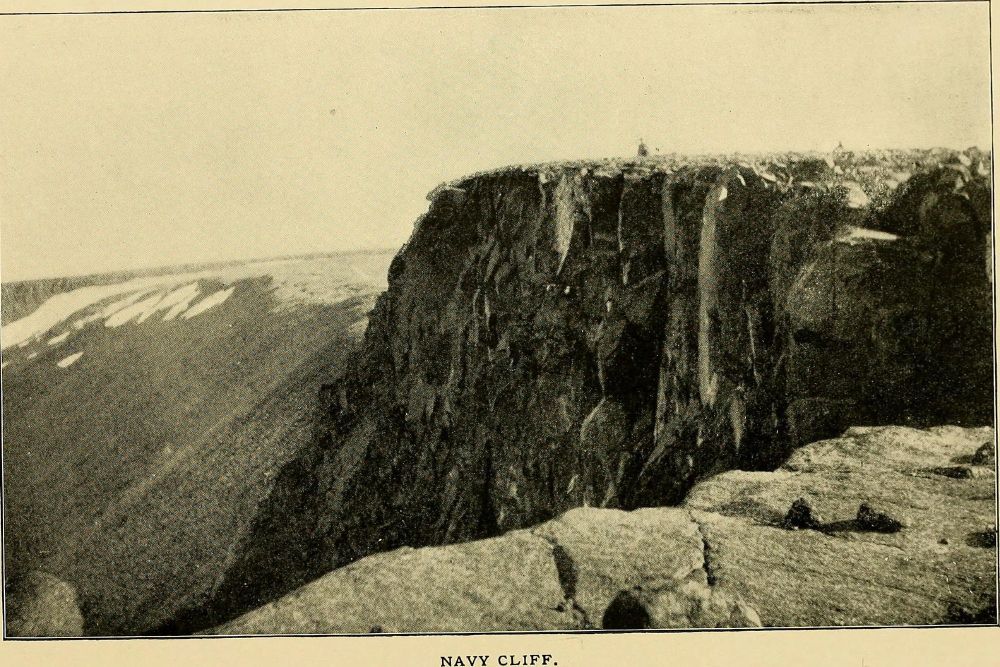
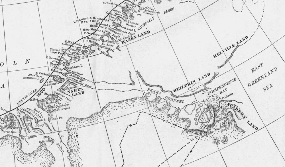
#OTD in 1892, US explorer Robert Peary looked out over Navy Cliff in NE Greenland and incorrectly determined the island was split in two by a giant fjord.
The race to prove that 'Peary Channel' was a myth would have disastrous consequences for subsequent Danish expeditions.
The race to prove that 'Peary Channel' was a myth would have disastrous consequences for subsequent Danish expeditions.


July 4, 2025 at 9:56 PM
#OTD in 1892, US explorer Robert Peary looked out over Navy Cliff in NE Greenland and incorrectly determined the island was split in two by a giant fjord.
The race to prove that 'Peary Channel' was a myth would have disastrous consequences for subsequent Danish expeditions.
The race to prove that 'Peary Channel' was a myth would have disastrous consequences for subsequent Danish expeditions.
New short below on the disastrous Polaris Expedition, murder, and the myth of President Land 🎬

Murder at the North Pole?
YouTube video by Map Myths
youtube.com
July 2, 2025 at 8:48 PM
New short below on the disastrous Polaris Expedition, murder, and the myth of President Land 🎬
In 1817, Captain Hammant claimed to have seen an island at 36°27'S, 127°2'E. Hammant further noted they saw Kangaroo Island 3 hours later, which, being 150 leagues away, made the position of his discovery very doubtful.
Still, 'Hammet' Island would survive on maps of Australia for nearly a century.
Still, 'Hammet' Island would survive on maps of Australia for nearly a century.


July 2, 2025 at 8:05 AM
In 1817, Captain Hammant claimed to have seen an island at 36°27'S, 127°2'E. Hammant further noted they saw Kangaroo Island 3 hours later, which, being 150 leagues away, made the position of his discovery very doubtful.
Still, 'Hammet' Island would survive on maps of Australia for nearly a century.
Still, 'Hammet' Island would survive on maps of Australia for nearly a century.
When Herald Island was discovered in 1849 during the search for the lost expedition of Sir John Franklin, Captain Kellett reported seeing 'extensive and high land' no less than 60 miles from their ship.
The high peaks were named Plover Island, yet it was just a mirage.
📖 mapmyths.com#plover-island
The high peaks were named Plover Island, yet it was just a mirage.
📖 mapmyths.com#plover-island

June 29, 2025 at 8:48 AM
When Herald Island was discovered in 1849 during the search for the lost expedition of Sir John Franklin, Captain Kellett reported seeing 'extensive and high land' no less than 60 miles from their ship.
The high peaks were named Plover Island, yet it was just a mirage.
📖 mapmyths.com#plover-island
The high peaks were named Plover Island, yet it was just a mirage.
📖 mapmyths.com#plover-island