Landsat 🛰️
@landsat.bsky.social
1.1K followers
990 following
200 posts
🛰️📡 Unofficial mirror/fan account for the Landsat Program, a series of Earth-observing satellites co-managed by USGS & NASA, imaging the Earth since 1972. Posts do not necessarily reflect the views of USGS or NASA.
Posts
Media
Videos
Starter Packs
Reposted by Landsat 🛰️

Pete Tuckett
@petetuckett.bsky.social
· Jul 4
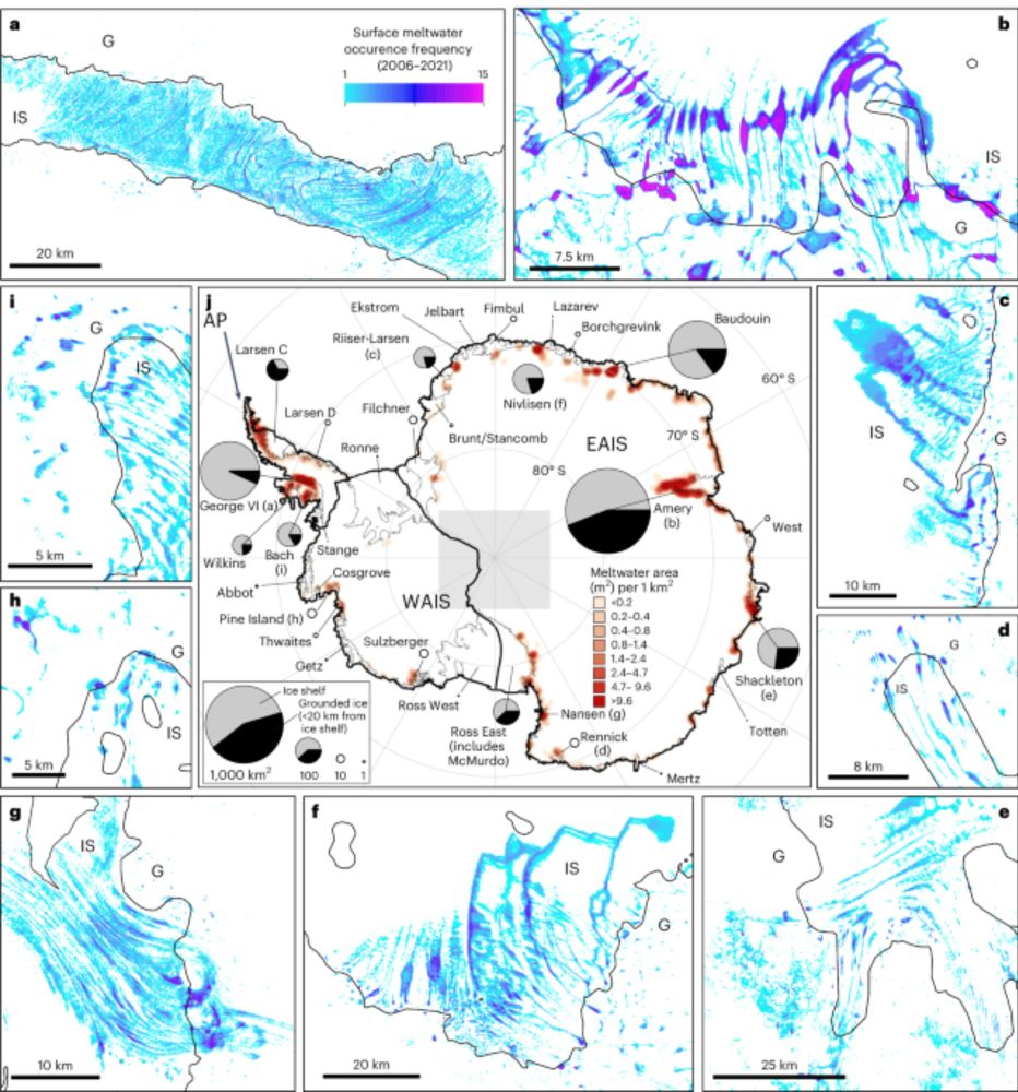
Continent-wide mapping shows increasing sensitivity of East Antarctica to meltwater ponding - Nature Climate Change
This study provides a continent-wide assessment of surface meltwater area in Antarctica between 2006 and 2021, highlighting recent increases in magnitude and variability in East Antarctica, with indic...
www.nature.com
Reposted by Landsat 🛰️

Moriarty Maps
@moriartymaps.com
· Jun 30

Pentagon will no longer share satellite data that tracks hurricanes overnight, @byscottdance.com: www.washingtonpost.com/weather/2025...

Pentagon will no longer share satellite data that tracks hurricanes overnight
Scientists were initially given less than a week to prepare for the loss of microwave observations that are key in detecting rapid intensification of storms.
www.washingtonpost.com
Reposted by Landsat 🛰️

Marvin Heiferman
@whywelook.bsky.social
· Jun 26

Final photo from iconic US satellite shows how Las Vegas has 'doubled' in size over the last 25 years
The final image captured by the recently decommissioned Landsat 7 satellite shows how "Sin City" has nearly doubled in size during the iconic spacecraft's 25-year lifespan.
www.livescience.com
Reposted by Landsat 🛰️


Reposted by Landsat 🛰️


Reposted by Landsat 🛰️


Reposted by Landsat 🛰️


Reposted by Landsat 🛰️
Reposted by Landsat 🛰️


Reposted by Landsat 🛰️
Landsat 🛰️
@landsat.bsky.social
· Jun 3


Reposted by Landsat 🛰️


Reposted by Landsat 🛰️