


@jdesbonnet.bsky.social
A drone image I acquired earlier today (2025-11-06) while trying out some experimental survey equipment near Menlo just north of #Galway city. In foreground is Menlo Castle (in ruins) and the Corrib River. University of Galway campus and Galway city is in the back ground.

November 6, 2025 at 11:36 PM
A drone image I acquired earlier today (2025-11-06) while trying out some experimental survey equipment near Menlo just north of #Galway city. In foreground is Menlo Castle (in ruins) and the Corrib River. University of Galway campus and Galway city is in the back ground.
Why is every question I ask ChatGPT a "really good question"? I mean if I get much more of this I might start having notions about myself.
October 16, 2025 at 6:07 PM
Why is every question I ask ChatGPT a "really good question"? I mean if I get much more of this I might start having notions about myself.
Reposted
Dublin! I'll be meeting folks and hand-signing books this Saturday, 11:30 at Dubray Books on Grafton St!
@dubraybooks.bsky.social
@dubraybooks.bsky.social

October 15, 2025 at 11:36 AM
Dublin! I'll be meeting folks and hand-signing books this Saturday, 11:30 at Dubray Books on Grafton St!
@dubraybooks.bsky.social
@dubraybooks.bsky.social
I was looking through some night time photos from the International Space Station (ISS) recently. This image from 2022 caught my eye: what (I think) you can see here is the phased transition from the old sodium vapor street lamps (orange) to LEDs (white). Image ISS066-E-122202
2022-01-19T21:16:26Z
2022-01-19T21:16:26Z

October 8, 2025 at 12:20 PM
I was looking through some night time photos from the International Space Station (ISS) recently. This image from 2022 caught my eye: what (I think) you can see here is the phased transition from the old sodium vapor street lamps (orange) to LEDs (white). Image ISS066-E-122202
2022-01-19T21:16:26Z
2022-01-19T21:16:26Z
The chances of a credit card transaction succeeding first time seems inversely proportional to how excited I am about the purchase :/
September 30, 2025 at 9:02 PM
The chances of a credit card transaction succeeding first time seems inversely proportional to how excited I am about the purchase :/
Always nice to see transport companies use sensible date formats!

September 19, 2025 at 3:09 PM
Always nice to see transport companies use sensible date formats!
I recall as an student at UoG (then UCG) in the 1990s there were two research turbines at the engineering building at Nuns Island using the canal waters as a power source. Seems we have come full circle.

€3.3m for Galway canal turbines to supply free city electricity - Connacht Tribune - Galway City Tribune
€3.3m for Galway canal turbines to supply free city electricity
connachttribune.ie
September 12, 2025 at 9:48 PM
I recall as an student at UoG (then UCG) in the 1990s there were two research turbines at the engineering building at Nuns Island using the canal waters as a power source. Seems we have come full circle.
nothing more annoying than "add another €8 to your shopping cart to qualify for free shipping". Off now to spend another 30 minutes trying to find something I probably don't need :/
August 31, 2025 at 7:59 PM
nothing more annoying than "add another €8 to your shopping cart to qualify for free shipping". Off now to spend another 30 minutes trying to find something I probably don't need :/
"wget is not a crime" ('Jason Bourne' 2016 movie). I didn't spot that on my first viewing.

August 15, 2025 at 9:46 PM
"wget is not a crime" ('Jason Bourne' 2016 movie). I didn't spot that on my first viewing.
The 'Manchurian Candidate' movie comes to mind here.

USSR sweatshirt and chicken kyiv: Russia dials up trolling before Alaska summit
Foreign minister’s attire and inflight menu for Russian media are latest in series of provocations towards Ukraine
www.theguardian.com
August 15, 2025 at 2:15 PM
The 'Manchurian Candidate' movie comes to mind here.
Reposted
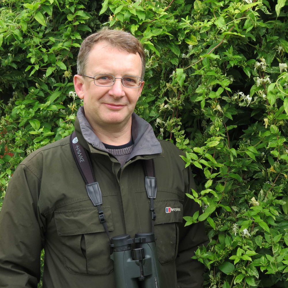
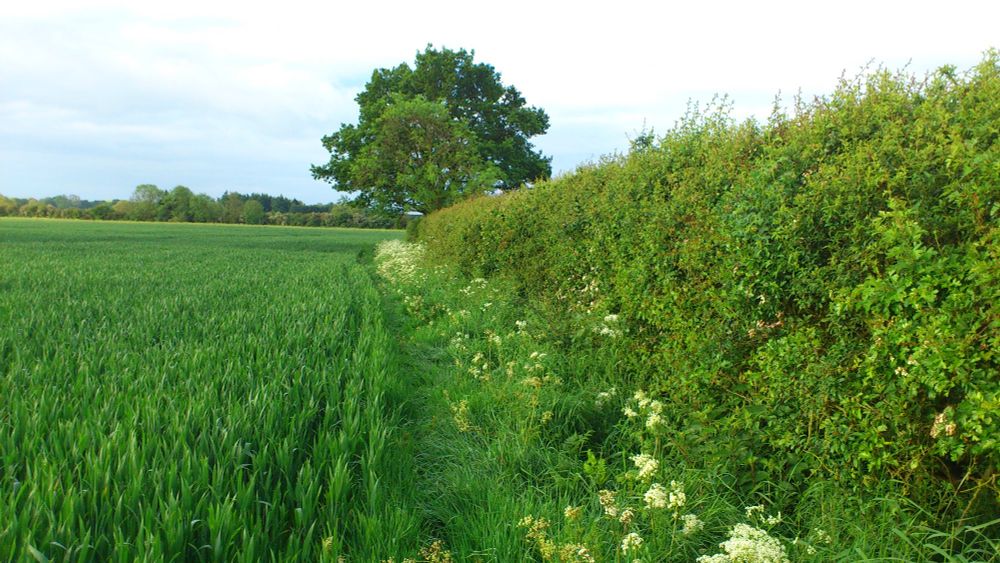
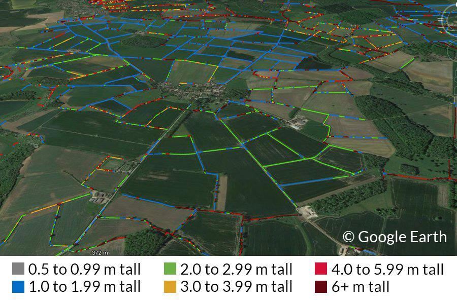
New #OpenAccess paper, describing/validating our hedgerows map using #lidar and Countryside Survey.
641,080 km of woody linear features in England
A lidar based national model of hedgerows and other woody linear features in rural England: www.sciencedirect.com/science/arti... @ukceh.bsky.social
641,080 km of woody linear features in England
A lidar based national model of hedgerows and other woody linear features in rural England: www.sciencedirect.com/science/arti... @ukceh.bsky.social
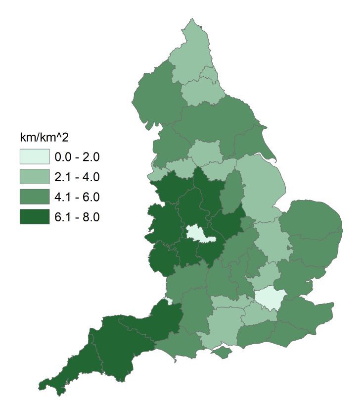

July 24, 2025 at 10:38 AM
New #OpenAccess paper, describing/validating our hedgerows map using #lidar and Countryside Survey.
641,080 km of woody linear features in England
A lidar based national model of hedgerows and other woody linear features in rural England: www.sciencedirect.com/science/arti... @ukceh.bsky.social
641,080 km of woody linear features in England
A lidar based national model of hedgerows and other woody linear features in rural England: www.sciencedirect.com/science/arti... @ukceh.bsky.social
This is depressing 😕 youtube.com/watch?v=4f9z...

I’ve got bad news from the Ukraine frontlines
YouTube video by Caolan Robertson
youtube.com
July 29, 2025 at 5:28 PM
This is depressing 😕 youtube.com/watch?v=4f9z...
Reposted

An AI-enabled urinal?
...
Hey y'all
I think I know what triggers the Robot uprising.
...
Hey y'all
I think I know what triggers the Robot uprising.

June 25, 2025 at 6:35 AM
An AI-enabled urinal?
...
Hey y'all
I think I know what triggers the Robot uprising.
...
Hey y'all
I think I know what triggers the Robot uprising.
Reposted

Recently, I came across the web-based, interactive, & #opensource Optical Simulation tool #OPTICO 🔬 that allows students to virtually play around with mirrors, lenses, etc. 🚀 - You should try it out #openscience #openeducation #optics #photonics #microscopy 👉 www.optico.app/en/start-en/

January 3, 2024 at 8:40 PM
Recently, I came across the web-based, interactive, & #opensource Optical Simulation tool #OPTICO 🔬 that allows students to virtually play around with mirrors, lenses, etc. 🚀 - You should try it out #openscience #openeducation #optics #photonics #microscopy 👉 www.optico.app/en/start-en/
The Russian Doll packaging of AliExpress: gadgets in cases in boxes in bubble wrap in padded envelopes in plastic bags all bagged together in outer bag. (Multiple small orders all consolidated into one local courier shipment). Impressive logistics if a little wasteful on packaging.

June 21, 2025 at 10:01 AM
The Russian Doll packaging of AliExpress: gadgets in cases in boxes in bubble wrap in padded envelopes in plastic bags all bagged together in outer bag. (Multiple small orders all consolidated into one local courier shipment). Impressive logistics if a little wasteful on packaging.
"Give me a ping Vasili, one ping only"

June 15, 2025 at 11:22 PM
"Give me a ping Vasili, one ping only"
🍿🍿🍿

Elon Musk escalates war of words with Trump after president threatens to terminate government contracts – live
In flurry of X posts, former adviser hits out at Trump - including threat to decommission Dragon spacecraft - as allies-turned-enemies spar on social media
www.theguardian.com
June 5, 2025 at 9:49 PM
🍿🍿🍿
Reposted

New GPS/GNSS spoofing pattern unlocked.
"red sea petal spoofer" perhaps? Thanks @tombike.bsky.social for tip.
"red sea petal spoofer" perhaps? Thanks @tombike.bsky.social for tip.
May 21, 2025 at 7:18 PM
New GPS/GNSS spoofing pattern unlocked.
"red sea petal spoofer" perhaps? Thanks @tombike.bsky.social for tip.
"red sea petal spoofer" perhaps? Thanks @tombike.bsky.social for tip.
Reposted
I believe the Kaliningrad and St Petersburg (and more?) spoof-jammers have increased their reach significantly.
The area around Baltic Sea presently affected by electronic warfare directed at GNSS/GPS-receivers is enormous, larger than before.
Bbl with a timelapse. Nb, this is reach at 10-30k ft.
The area around Baltic Sea presently affected by electronic warfare directed at GNSS/GPS-receivers is enormous, larger than before.
Bbl with a timelapse. Nb, this is reach at 10-30k ft.

May 27, 2025 at 9:11 PM
I believe the Kaliningrad and St Petersburg (and more?) spoof-jammers have increased their reach significantly.
The area around Baltic Sea presently affected by electronic warfare directed at GNSS/GPS-receivers is enormous, larger than before.
Bbl with a timelapse. Nb, this is reach at 10-30k ft.
The area around Baltic Sea presently affected by electronic warfare directed at GNSS/GPS-receivers is enormous, larger than before.
Bbl with a timelapse. Nb, this is reach at 10-30k ft.
"The boss has organized a day out at the zoo. Everyone meet at the lions cage."

Kim Jong-un furious as North Korea warship partly ‘crushed’ in launch gone wrong
South Korea said the destroyer was lying sideways in the water after ceremony to launch the new 5,000-tonne ship
www.theguardian.com
May 22, 2025 at 3:26 PM
"The boss has organized a day out at the zoo. Everyone meet at the lions cage."
The dryin' is mighty! 🌞

May 21, 2025 at 6:33 PM
The dryin' is mighty! 🌞
Reposted
Good read.
And remember ... It all started with Putin deciding that the Russian Constitution, and the term limit contained within, didn't apply to him.
Pay attention.
thenextmove.substack.com/p/space-unit...
And remember ... It all started with Putin deciding that the Russian Constitution, and the term limit contained within, didn't apply to him.
Pay attention.
thenextmove.substack.com/p/space-unit...

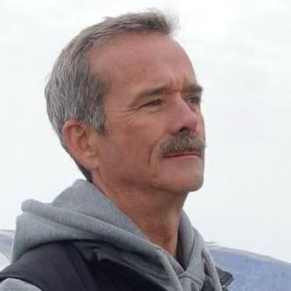
Space United Us. Putin Tore Us Apart.
Former International Space Station commander: Watching my Russian cosmonaut friends turn to the dark side was a troubling lesson in how easily normal people can be bribed into supporting a tyrant.
thenextmove.substack.com
May 17, 2025 at 11:02 AM
Good read.
And remember ... It all started with Putin deciding that the Russian Constitution, and the term limit contained within, didn't apply to him.
Pay attention.
thenextmove.substack.com/p/space-unit...
And remember ... It all started with Putin deciding that the Russian Constitution, and the term limit contained within, didn't apply to him.
Pay attention.
thenextmove.substack.com/p/space-unit...

Reposted
There are a lot of *interesting* hot takes on Pope Leo XIV.
Many of them are bemoaning an "American Pope" b/c of Trump.
I understand. I feel you.
But PLEASE... take a moment to look at the man's history.
He is NOT the American that Trump & Vance wanted as Pope.
Many of them are bemoaning an "American Pope" b/c of Trump.
I understand. I feel you.
But PLEASE... take a moment to look at the man's history.
He is NOT the American that Trump & Vance wanted as Pope.
May 8, 2025 at 6:47 PM
There are a lot of *interesting* hot takes on Pope Leo XIV.
Many of them are bemoaning an "American Pope" b/c of Trump.
I understand. I feel you.
But PLEASE... take a moment to look at the man's history.
He is NOT the American that Trump & Vance wanted as Pope.
Many of them are bemoaning an "American Pope" b/c of Trump.
I understand. I feel you.
But PLEASE... take a moment to look at the man's history.
He is NOT the American that Trump & Vance wanted as Pope.