


Bruno M. Shirley
@brunomshirley.com
Historian of Buddhism, political thought, and gender in medieval Sri Lanka. Kiwi in Heidelberg. Big fan of nice maps.
He/Er/ඔහු/அவர்
He/Er/ඔහු/அவர்
What a delightful exemplar to come across, in the week my students have a book review due...

An academic disliked an Oxford Very Short Introduction (145 pages) in his field so much that he wrote a 200 page book review attacking it. www.pierre-legrand.com/ewExternalFi...
December 12, 2025 at 8:03 AM
What a delightful exemplar to come across, in the week my students have a book review due...
Ah, yes, my beloved archipelago in the South Pacific, that natural bastion of "the West"

The world's richest man, back on the white supremacist soapbox, where more diverse nations can only be seen as "The Doom of Western Civilization".
This is your brain on the so-called Great Replacement narrative.
This is your brain on the so-called Great Replacement narrative.

December 11, 2025 at 5:53 PM
Ah, yes, my beloved archipelago in the South Pacific, that natural bastion of "the West"
Tangentially related: I cannot understand why BA students in NZ aren't *required* to study a language—especially students like me who majored in international relations. I took one semester of Japanese, it was hard and my grades sucked, of course 20yr old me didn't think it was worth continuing!

Even if we would stipulate that the *only* purpose of college is vocational training (ugh) if you think you, at 18 years old, not only know for sure what your future career will be but also know better than all the professors at a college what skills you will need for that career, why bother?
December 9, 2025 at 8:06 PM
Tangentially related: I cannot understand why BA students in NZ aren't *required* to study a language—especially students like me who majored in international relations. I took one semester of Japanese, it was hard and my grades sucked, of course 20yr old me didn't think it was worth continuing!
I wrote a book, it now has a cover, it's all feeling very real! Coming out (open access) in February, for all those with an interest in, well, religion, gender, and/or politics in Sri Lankan history.
www.arc-humanities.org/978180270309...
www.arc-humanities.org/978180270309...

Religion, Gender, and Politics in Medieval Sri Lanka - Arc Humanities Press
The early second millennium was a pivotal moment in the history of Theravāda Buddhism. Religious reforms carried out at Poḷonnaruva, then-capital of Sri L...
www.arc-humanities.org
December 3, 2025 at 8:01 AM
I wrote a book, it now has a cover, it's all feeling very real! Coming out (open access) in February, for all those with an interest in, well, religion, gender, and/or politics in Sri Lankan history.
www.arc-humanities.org/978180270309...
www.arc-humanities.org/978180270309...
Reposted by Bruno M. Shirley

People vastly underestimate how important trans* rights are in the contemporary fight for freedom.
If you cannot make your own choices for your body, the name you go by, or even the very clothes that you wear, then you are not, in any sense, meaningfully free.
If you cannot make your own choices for your body, the name you go by, or even the very clothes that you wear, then you are not, in any sense, meaningfully free.
November 26, 2025 at 7:25 PM
People vastly underestimate how important trans* rights are in the contemporary fight for freedom.
If you cannot make your own choices for your body, the name you go by, or even the very clothes that you wear, then you are not, in any sense, meaningfully free.
If you cannot make your own choices for your body, the name you go by, or even the very clothes that you wear, then you are not, in any sense, meaningfully free.
It's very "university IT department" to make it mandatory for us to use the VPN to check our emails... The same day that the VPN crashes.
I'm sure that they've sent a very helpful email by now with a workaround! If only...
I'm sure that they've sent a very helpful email by now with a workaround! If only...
November 19, 2025 at 10:14 AM
It's very "university IT department" to make it mandatory for us to use the VPN to check our emails... The same day that the VPN crashes.
I'm sure that they've sent a very helpful email by now with a workaround! If only...
I'm sure that they've sent a very helpful email by now with a workaround! If only...
Reposted by Bruno M. Shirley

📸 New research just out revealing disturbing problems with AI image captioning. AI models can now analyse both texts and images, and are trained on vast collections of human-created content spanning centuries. Some claims these models could soon help human historians interpret and explain the past.

November 15, 2025 at 12:13 PM
📸 New research just out revealing disturbing problems with AI image captioning. AI models can now analyse both texts and images, and are trained on vast collections of human-created content spanning centuries. Some claims these models could soon help human historians interpret and explain the past.
I shall henceforth always refer to GenAI as "the gibbering mouth froth of rabid autocomplete."
(also this book and interview are both generally excellent)
(also this book and interview are both generally excellent)
I have a new interview about RAKESFALL up at Reactor! In which I am quite verbose reactormag.com/author-inter...

A Conversation With Vajra Chandrasekera, Author of Rakesfall - Reactor
"I think writers, like all artists, have a responsibility to act as human cultural workers in an actual society"
reactormag.com
November 11, 2025 at 2:25 PM
I shall henceforth always refer to GenAI as "the gibbering mouth froth of rabid autocomplete."
(also this book and interview are both generally excellent)
(also this book and interview are both generally excellent)
The line "Señorita, feel the conga, let me see you move LIKE you come from Colombia" has never made much sense to me since Shakira actually DOES come from Colombia. Please enjoy these alternatives, with which I have been torturing my Colombian partner all day.
November 10, 2025 at 5:41 PM
The line "Señorita, feel the conga, let me see you move LIKE you come from Colombia" has never made much sense to me since Shakira actually DOES come from Colombia. Please enjoy these alternatives, with which I have been torturing my Colombian partner all day.
This is a great read, well worth a subscription to the Examiner. A substantial preview of the article is available above the paywall too www.examiner.media/conclave-in-...

Conclave in Kandy: election for the ‘highest lay office in the Buddhist world’
The Kandyans will elect the next Diyawadana Nilame this evening. He will oversee the tooth relic and the Maligawa’s worldly affairs. Seven candidates are contesting, including a university lecturer, a...
www.examiner.media
November 7, 2025 at 8:34 AM
This is a great read, well worth a subscription to the Examiner. A substantial preview of the article is available above the paywall too www.examiner.media/conclave-in-...
This could be my opportunity to stake out my own niche of academic Brunoism

IMPORTANT update
there are NO gifs of Bruno Latour. it just suggests various clips of Bruno Mars which honestly is not the right vibe
there are NO gifs of Bruno Latour. it just suggests various clips of Bruno Mars which honestly is not the right vibe
as an over enthusiastic user of gifs i regret to inform any of you who didn’t already know this unsurprising but depressing fact: the gif libraries on these platforms are all flooded with generated videos now
November 4, 2025 at 4:59 PM
This could be my opportunity to stake out my own niche of academic Brunoism
#WebinAAR | On Friday 7 Nov, at 12pm ET / 6pm CET, I’ll be speaking in an AAR webinar on Buddhist feminist historiography, in conversation with Steph Balkwill and other excellent folks. Q and A follows; register now and join the discussion: my.aarweb.org/event-inform...

November 4, 2025 at 11:36 AM
#WebinAAR | On Friday 7 Nov, at 12pm ET / 6pm CET, I’ll be speaking in an AAR webinar on Buddhist feminist historiography, in conversation with Steph Balkwill and other excellent folks. Q and A follows; register now and join the discussion: my.aarweb.org/event-inform...
Reposted by Bruno M. Shirley

Academics in Assyria in the 7th c BC complain that admin is preventing them from doing research and teaching

November 3, 2025 at 10:04 AM
Academics in Assyria in the 7th c BC complain that admin is preventing them from doing research and teaching
This is, with the benefit of Atlantic distance, hilarious. It is also deeply, deeply disturbing.

Open the page. Scroll down to the timeline. Go through the timeline.
It’s… shocking
It’s… shocking

The White House Building
Every president since John Adams has occupied the White House, and the history of this building extends far beyond the construction of its walls. From the Ground Floor Corridor rooms, transformed from...
www.whitehouse.gov
October 24, 2025 at 7:18 PM
This is, with the benefit of Atlantic distance, hilarious. It is also deeply, deeply disturbing.
Good copyedits need a good kittyeditor

September 29, 2025 at 2:45 PM
Good copyedits need a good kittyeditor
I have lived in Germany for two years now and still whenever I hear small children chatting away in public my first thought is "wow their German is so good, they must study very hard"
August 8, 2025 at 5:15 PM
I have lived in Germany for two years now and still whenever I hear small children chatting away in public my first thought is "wow their German is so good, they must study very hard"
Reposted by Bruno M. Shirley

New #cfp from the Journal of Transcultural Studies for a special issue on “Transcultural Histories of Monarchy” - abstracts to be sent to [email protected] by 1st Sept!
The essays will explore the ways in which monarchies incorporate “the foreign” into the familiar.
The essays will explore the ways in which monarchies incorporate “the foreign” into the familiar.
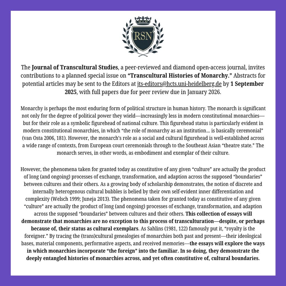
August 1, 2025 at 12:20 PM
New #cfp from the Journal of Transcultural Studies for a special issue on “Transcultural Histories of Monarchy” - abstracts to be sent to [email protected] by 1st Sept!
The essays will explore the ways in which monarchies incorporate “the foreign” into the familiar.
The essays will explore the ways in which monarchies incorporate “the foreign” into the familiar.
Stephanie Balkwill's The Women Who Ruled China is an incredible book, with methodological takeaways for historians of gender and power in every context. Read my review for @royalstudies.bsky.social here: rsj.winchester.ac.uk/articles/10....

The Women Who Ruled China: Buddhism, Multiculturalism, and Governance in the Sixth Century. By Stephanie Balkwill. University of California Press, 2024. ISBN: 978-0520401815. 272 pp | Royal Studies Jo...
rsj.winchester.ac.uk
July 5, 2025 at 11:37 AM
Stephanie Balkwill's The Women Who Ruled China is an incredible book, with methodological takeaways for historians of gender and power in every context. Read my review for @royalstudies.bsky.social here: rsj.winchester.ac.uk/articles/10....
I've just had an article come out on a poem from medieval Sri Lanka, and what it might tell us about attitudes towards renunciation, religious paths, and the proximate goals of Buddhist practice: pwj.shin-ibs.edu/2025/7164

Buddhist Poetics in Medieval Sri Lanka: The Muvadev-dā-vata Reconsidered
This article offers a close reading of the twelfth-century Muvadev-dā-vata, one of the earliest Sinhala-language poetic works to model itself on the Sanskrit kāvya. While earlier studies of the Muv…
pwj.shin-ibs.edu
June 2, 2025 at 9:20 AM
I've just had an article come out on a poem from medieval Sri Lanka, and what it might tell us about attitudes towards renunciation, religious paths, and the proximate goals of Buddhist practice: pwj.shin-ibs.edu/2025/7164
Just days before Vesak, Sotheby's plan to auction off sacred relics of the Buddha—stolen in the colonial destruction of a stūpa, no less—to the highest bidder.
religionnews.com/2025/04/22/a...
religionnews.com/2025/04/22/a...

Auctioning the Buddha's relics is perpetuating colonial violence
(RNS) — For the Buddhists who deposited these relics — as for Buddhists today — the gems, bone and ash all belong to the Buddha and shouldn’t just be sold to the highest bidder.
religionnews.com
May 2, 2025 at 9:16 AM
Just days before Vesak, Sotheby's plan to auction off sacred relics of the Buddha—stolen in the colonial destruction of a stūpa, no less—to the highest bidder.
religionnews.com/2025/04/22/a...
religionnews.com/2025/04/22/a...
A new issue of the Journal of Transcultural Studies is now available open-access! It features articles by @jaydprosser.bsky.social (Leeds), Alexander Vesey (Tokyo), Ori Sela (Tel Aviv) and Dhruv Raina (New Delhi/Pune).
Great reads all; check them out here:
heiup.uni-heidelberg.de/journals/tra...
Great reads all; check them out here:
heiup.uni-heidelberg.de/journals/tra...
Vol. 15 No. 1-2 (2024)
| The Journal of Transcultural Studies
heiup.uni-heidelberg.de
March 7, 2025 at 2:23 PM
A new issue of the Journal of Transcultural Studies is now available open-access! It features articles by @jaydprosser.bsky.social (Leeds), Alexander Vesey (Tokyo), Ori Sela (Tel Aviv) and Dhruv Raina (New Delhi/Pune).
Great reads all; check them out here:
heiup.uni-heidelberg.de/journals/tra...
Great reads all; check them out here:
heiup.uni-heidelberg.de/journals/tra...
Reposted by Bruno M. Shirley

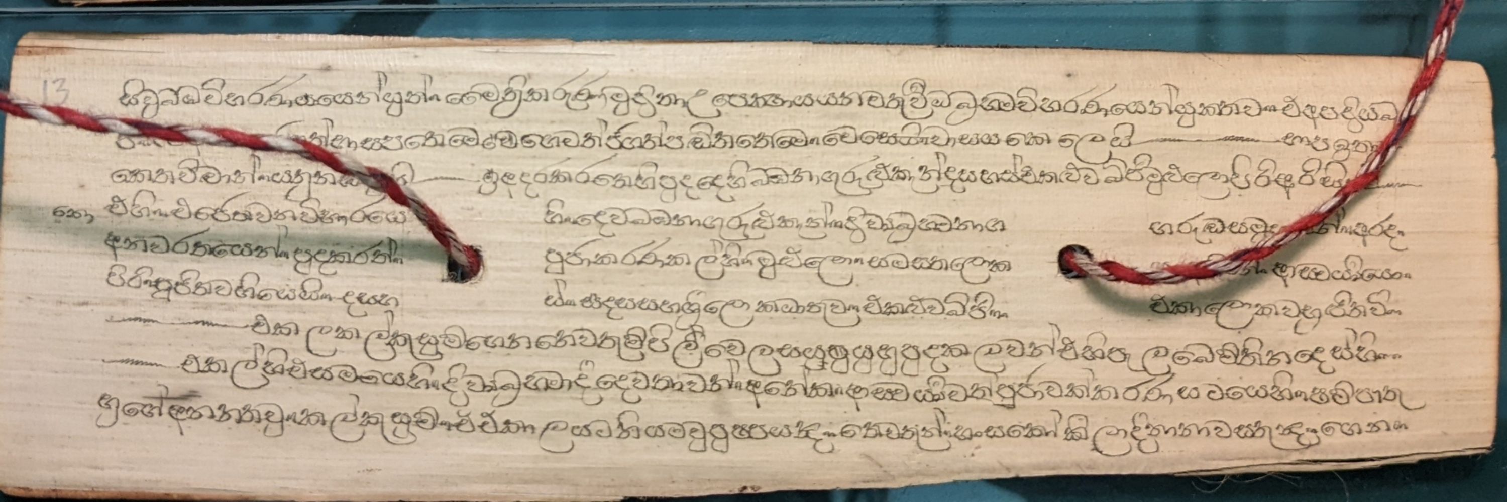
This is interesting. "Leading AI Models are now very good historians". It's a total clickbait title as I will expand on below. But several of the challenges put to the models, particularly palaeographical transcription and translation, it seems to perform well. Wills @ Exeter is using it for this.1
The leading AI models are now very good historians
Three case studies with GPT-4o, o1, and Claude Sonnet 3.5, and what they mean
resobscura.substack.com
January 27, 2025 at 12:32 PM
This is interesting. "Leading AI Models are now very good historians". It's a total clickbait title as I will expand on below. But several of the challenges put to the models, particularly palaeographical transcription and translation, it seems to perform well. Wills @ Exeter is using it for this.1
Reposted by Bruno M. Shirley

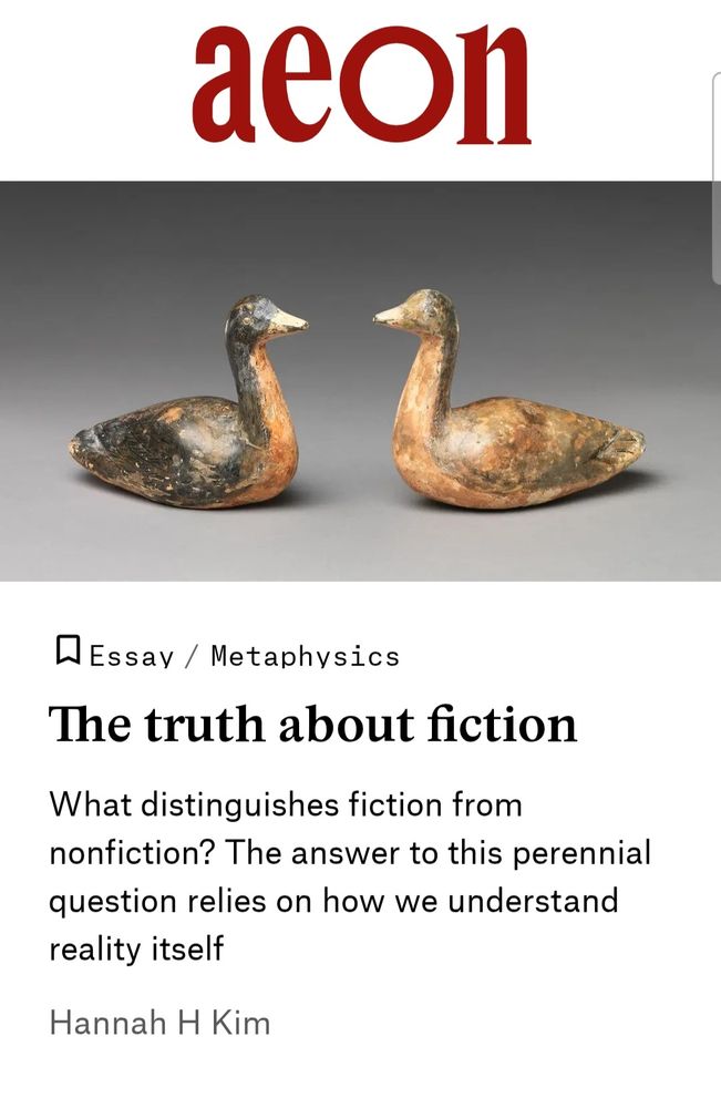
If you need a distraction today-- check out my new piece for Aeon!
I say there's no universal definition of fiction b/c how "fiction" is understood depends on a culture's metaphysics. Philosophy of fiction has been taking Greek metaphysics for granted. I say we branch out.
aeon.co/essays/befor...
I say there's no universal definition of fiction b/c how "fiction" is understood depends on a culture's metaphysics. Philosophy of fiction has been taking Greek metaphysics for granted. I say we branch out.
aeon.co/essays/befor...
January 20, 2025 at 3:55 PM
If you need a distraction today-- check out my new piece for Aeon!
I say there's no universal definition of fiction b/c how "fiction" is understood depends on a culture's metaphysics. Philosophy of fiction has been taking Greek metaphysics for granted. I say we branch out.
aeon.co/essays/befor...
I say there's no universal definition of fiction b/c how "fiction" is understood depends on a culture's metaphysics. Philosophy of fiction has been taking Greek metaphysics for granted. I say we branch out.
aeon.co/essays/befor...
Historian friends, here's a new years resolution for you: no more Google Maps screenshots in your powerpoints! Thanks to Technology™ it's easy and free to make maps from scratch that look professional (or at least professional enough), even with my level of extremely limited technical skills.
January 3, 2025 at 2:32 PM
Historian friends, here's a new years resolution for you: no more Google Maps screenshots in your powerpoints! Thanks to Technology™ it's easy and free to make maps from scratch that look professional (or at least professional enough), even with my level of extremely limited technical skills.