


AnnoNemo
@annonemo.bsky.social
Geolocation| A Palestinian, reportedly Dr. Marwan Al-Hams, being taken by several people from a structure opposite the Red Cross Field Hospital, Al-Mawasi, South #Gaza
31.342692, 34.242748
🗓️21 July 2025
w/ verification help from @fdov21.bsky.social
Video: (1:36-1:41) www.ynet.co.il/news/article...
31.342692, 34.242748
🗓️21 July 2025
w/ verification help from @fdov21.bsky.social
Video: (1:36-1:41) www.ynet.co.il/news/article...

November 27, 2025 at 11:54 PM
Geolocation| A Palestinian, reportedly Dr. Marwan Al-Hams, being taken by several people from a structure opposite the Red Cross Field Hospital, Al-Mawasi, South #Gaza
31.342692, 34.242748
🗓️21 July 2025
w/ verification help from @fdov21.bsky.social
Video: (1:36-1:41) www.ynet.co.il/news/article...
31.342692, 34.242748
🗓️21 July 2025
w/ verification help from @fdov21.bsky.social
Video: (1:36-1:41) www.ynet.co.il/news/article...
Reposted by AnnoNemo

Summary execution of two Palestinians by the Israeli military geolocated in Jabal Abu Dhahir, Jenin city ~ 32.454360, 35.297587.

November 27, 2025 at 6:01 PM
Summary execution of two Palestinians by the Israeli military geolocated in Jabal Abu Dhahir, Jenin city ~ 32.454360, 35.297587.
Geolocation| Search efforts for the bodies of killed residents, reportedly at the Al-Nawasra family house in the Maghazi Camp, Central #Gaza
31.427849, 34.383184
🗓️22 Nov. 2025
Video: www.youtube.com/watch?v=wXq8...
Photos: www.facebook.com/maghazimun/p...
31.427849, 34.383184
🗓️22 Nov. 2025
Video: www.youtube.com/watch?v=wXq8...
Photos: www.facebook.com/maghazimun/p...


November 23, 2025 at 12:14 PM
Geolocation| Search efforts for the bodies of killed residents, reportedly at the Al-Nawasra family house in the Maghazi Camp, Central #Gaza
31.427849, 34.383184
🗓️22 Nov. 2025
Video: www.youtube.com/watch?v=wXq8...
Photos: www.facebook.com/maghazimun/p...
31.427849, 34.383184
🗓️22 Nov. 2025
Video: www.youtube.com/watch?v=wXq8...
Photos: www.facebook.com/maghazimun/p...
Reposted by AnnoNemo
Building in Nuseirat refugee camp belonging to the Abu Shawish family targeted by an Israeli airstrike yesterday ~ 31.440389, 34.382472.

November 23, 2025 at 11:26 AM
Building in Nuseirat refugee camp belonging to the Abu Shawish family targeted by an Israeli airstrike yesterday ~ 31.440389, 34.382472.
Reposted by AnnoNemo
Aftermath of the Israeli airstrike on the Abed family residence near Bilal bin Rabah Mosque in Deir al-Balah, 31.422967, 34.350925.

November 22, 2025 at 9:11 PM
Aftermath of the Israeli airstrike on the Abed family residence near Bilal bin Rabah Mosque in Deir al-Balah, 31.422967, 34.350925.
Geolocation| Explosion, carried out by Israeli forces, amid vast destruction in the Shujaiya neighborhood, eastern Gaza City, Northern #Gaza
31.500334, 34.477942
Posted on 18 Nov. 2025
It was possibly the detonation of a remotely-controlled M113 vehicle.
Video: t.me/yinonews/46446
31.500334, 34.477942
Posted on 18 Nov. 2025
It was possibly the detonation of a remotely-controlled M113 vehicle.
Video: t.me/yinonews/46446


November 19, 2025 at 10:31 PM
Geolocation| Explosion, carried out by Israeli forces, amid vast destruction in the Shujaiya neighborhood, eastern Gaza City, Northern #Gaza
31.500334, 34.477942
Posted on 18 Nov. 2025
It was possibly the detonation of a remotely-controlled M113 vehicle.
Video: t.me/yinonews/46446
31.500334, 34.477942
Posted on 18 Nov. 2025
It was possibly the detonation of a remotely-controlled M113 vehicle.
Video: t.me/yinonews/46446
Geolocation| Water and garbage in the street at the entrance to the New Gaza Elementary Boys A&B School for Refugees, near the Al-Nasr Street, Gaza City, Northern #Gaza
31.525703, 34.449988
🗓️13 Nov.
Photos & video: t.me/hamza20300/3...
31.525703, 34.449988
🗓️13 Nov.
Photos & video: t.me/hamza20300/3...

November 13, 2025 at 10:08 PM
Geolocation| Water and garbage in the street at the entrance to the New Gaza Elementary Boys A&B School for Refugees, near the Al-Nasr Street, Gaza City, Northern #Gaza
31.525703, 34.449988
🗓️13 Nov.
Photos & video: t.me/hamza20300/3...
31.525703, 34.449988
🗓️13 Nov.
Photos & video: t.me/hamza20300/3...
Geolocation| Israeli airstrike on 2 Palestinians walking in the Armida neighborhood of Bani Suheila, South #Gaza
31.326601, 34.327870
🗓️10 Nov. 2025
31.326601, 34.327870
🗓️10 Nov. 2025


November 13, 2025 at 10:07 PM
Geolocation| Israeli airstrike on 2 Palestinians walking in the Armida neighborhood of Bani Suheila, South #Gaza
31.326601, 34.327870
🗓️10 Nov. 2025
31.326601, 34.327870
🗓️10 Nov. 2025
Reposted by AnnoNemo

NEW: We’ve added 53 more white phosphorus strikes to our archive whitephosphorus.info, bringing the total to 248 verified and geolocated incidents across South #Lebanon (2023–2024).
The IDF says these were used as smokescreens, away from civilians.
Our findings show otherwise. 🧵
The IDF says these were used as smokescreens, away from civilians.
Our findings show otherwise. 🧵
November 11, 2025 at 3:38 PM
NEW: We’ve added 53 more white phosphorus strikes to our archive whitephosphorus.info, bringing the total to 248 verified and geolocated incidents across South #Lebanon (2023–2024).
The IDF says these were used as smokescreens, away from civilians.
Our findings show otherwise. 🧵
The IDF says these were used as smokescreens, away from civilians.
Our findings show otherwise. 🧵
Reposted by AnnoNemo
GeoSpy AI attempted to do a geolocation in the occupied West Bank in Palestine. However, nothing beats the human eye, as @annonemo.bsky.social showed that the correct location was actually 19.6 km from what the AI and it’s founder claimed it was: 32.113212, 35.133272.

November 9, 2025 at 10:57 PM
GeoSpy AI attempted to do a geolocation in the occupied West Bank in Palestine. However, nothing beats the human eye, as @annonemo.bsky.social showed that the correct location was actually 19.6 km from what the AI and it’s founder claimed it was: 32.113212, 35.133272.
Geolocation| An Israeli drone hits and injures an activist during an olive harvest near the Revava settlement in Deir Istiya, Salfit Governorate, occupied #WestBank
32.128986, 35.118375
📆 4 Nov. 2025
Video: x.com/MatanGolanPh...
32.128986, 35.118375
📆 4 Nov. 2025
Video: x.com/MatanGolanPh...

November 8, 2025 at 11:09 PM
Geolocation| An Israeli drone hits and injures an activist during an olive harvest near the Revava settlement in Deir Istiya, Salfit Governorate, occupied #WestBank
32.128986, 35.118375
📆 4 Nov. 2025
Video: x.com/MatanGolanPh...
32.128986, 35.118375
📆 4 Nov. 2025
Video: x.com/MatanGolanPh...
Geolocation| (0:00-0:47) A drone, reportely Israeli, drops something near the entrance to Shujaiya.
POV: 31.502345, 34.468009
🗓️ 5 Nov.
Armed Palestinians are visible too amid reported search operations for the body of a killed Israeli hostage.
bsky.app/profile/anno...
POV: 31.502345, 34.468009
🗓️ 5 Nov.
Armed Palestinians are visible too amid reported search operations for the body of a killed Israeli hostage.
bsky.app/profile/anno...


November 6, 2025 at 11:24 PM
Geolocation| (0:00-0:47) A drone, reportely Israeli, drops something near the entrance to Shujaiya.
POV: 31.502345, 34.468009
🗓️ 5 Nov.
Armed Palestinians are visible too amid reported search operations for the body of a killed Israeli hostage.
bsky.app/profile/anno...
POV: 31.502345, 34.468009
🗓️ 5 Nov.
Armed Palestinians are visible too amid reported search operations for the body of a killed Israeli hostage.
bsky.app/profile/anno...
Geolocation| Israeli forces, reportedly from the 1st "Golani" Brigade on Al-Quds Street, central #Gaza City, Northern #Gaza
31.517936, 34.434911
Posted on 18 Nov. 2023
Ref. photo: Saeed M. M. T. Jaras/Anadolu via Getty Images
Source: sparrows4palestine.substack.com/p/uoft-engin...
31.517936, 34.434911
Posted on 18 Nov. 2023
Ref. photo: Saeed M. M. T. Jaras/Anadolu via Getty Images
Source: sparrows4palestine.substack.com/p/uoft-engin...


November 6, 2025 at 11:22 AM
Geolocation| Israeli forces, reportedly from the 1st "Golani" Brigade on Al-Quds Street, central #Gaza City, Northern #Gaza
31.517936, 34.434911
Posted on 18 Nov. 2023
Ref. photo: Saeed M. M. T. Jaras/Anadolu via Getty Images
Source: sparrows4palestine.substack.com/p/uoft-engin...
31.517936, 34.434911
Posted on 18 Nov. 2023
Ref. photo: Saeed M. M. T. Jaras/Anadolu via Getty Images
Source: sparrows4palestine.substack.com/p/uoft-engin...
Geolocation| Israeli airstrike on a house in block C of the Nuseirat Camp, Central #Gaza
31.446905, 34.395168
🗓️Night of 28-29 Oct. 2025
Video: t.me/IDFSpokesper...
31.446905, 34.395168
🗓️Night of 28-29 Oct. 2025
Video: t.me/IDFSpokesper...


November 5, 2025 at 11:48 PM
Geolocation| Israeli airstrike on a house in block C of the Nuseirat Camp, Central #Gaza
31.446905, 34.395168
🗓️Night of 28-29 Oct. 2025
Video: t.me/IDFSpokesper...
31.446905, 34.395168
🗓️Night of 28-29 Oct. 2025
Video: t.me/IDFSpokesper...
Geolocation| (0:14-0:24) Israeli soldiers, reportedly from the Duvdevan unit, storm one of the Al-Azmouti Buildings near Al-Masākin ash Sha‘bīyah, NE of Nablus City, occupied #WestBank
32.223434, 35.303657
🗓️4 Nov.
Video: t.me/CaptainElla1...
32.223434, 35.303657
🗓️4 Nov.
Video: t.me/CaptainElla1...

November 5, 2025 at 12:03 AM
Geolocation| (0:14-0:24) Israeli soldiers, reportedly from the Duvdevan unit, storm one of the Al-Azmouti Buildings near Al-Masākin ash Sha‘bīyah, NE of Nablus City, occupied #WestBank
32.223434, 35.303657
🗓️4 Nov.
Video: t.me/CaptainElla1...
32.223434, 35.303657
🗓️4 Nov.
Video: t.me/CaptainElla1...
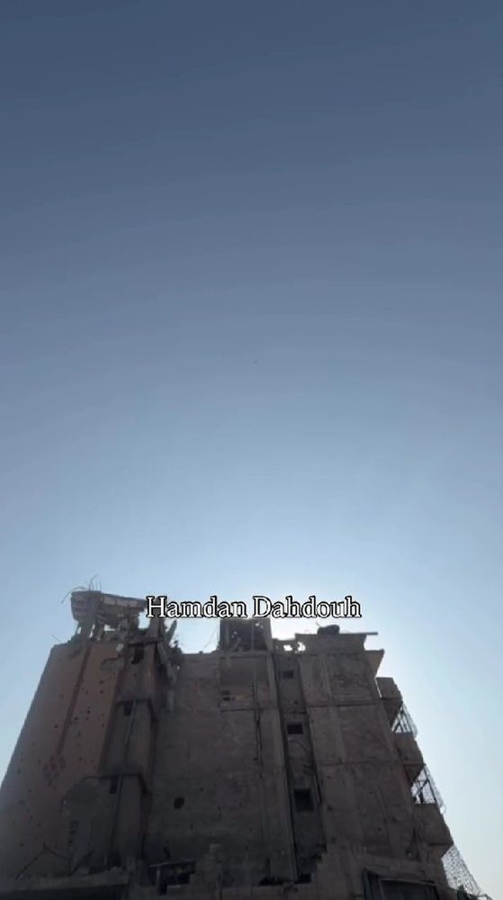
Geolocation| ICRC (Red Cross) vehicles, heavy equipment (some with the Egyptian flag) and armed Hamas fighters at the entrance to Shujaiya, eastern Gaza City, Northern #Gaza
31.502339, 34.467818
🗓️2 Nov.
Photos: instagram.com/p/DQjOb2PDlh4/
31.502339, 34.467818
🗓️2 Nov.
Photos: instagram.com/p/DQjOb2PDlh4/

November 2, 2025 at 10:54 AM
Geolocation| ICRC (Red Cross) vehicles, heavy equipment (some with the Egyptian flag) and armed Hamas fighters at the entrance to Shujaiya, eastern Gaza City, Northern #Gaza
31.502339, 34.467818
🗓️2 Nov.
Photos: instagram.com/p/DQjOb2PDlh4/
31.502339, 34.467818
🗓️2 Nov.
Photos: instagram.com/p/DQjOb2PDlh4/
Geolocation| A video posted on 31 Oct. shows aid trucks as well as a crowd and aid boxes on the ground on Salah Al-Din Street, South #Gaza
Start: ~31.388049, 34.343737
Approx. 300m from the CENTCOM video geolocated by
@fdov21.bsky.social: x.com/fdov21/statu...
Video: instagram.com/p/DQfZq_bDMeR/
Start: ~31.388049, 34.343737
Approx. 300m from the CENTCOM video geolocated by
@fdov21.bsky.social: x.com/fdov21/statu...
Video: instagram.com/p/DQfZq_bDMeR/

November 2, 2025 at 10:03 AM
Geolocation| A video posted on 31 Oct. shows aid trucks as well as a crowd and aid boxes on the ground on Salah Al-Din Street, South #Gaza
Start: ~31.388049, 34.343737
Approx. 300m from the CENTCOM video geolocated by
@fdov21.bsky.social: x.com/fdov21/statu...
Video: instagram.com/p/DQfZq_bDMeR/
Start: ~31.388049, 34.343737
Approx. 300m from the CENTCOM video geolocated by
@fdov21.bsky.social: x.com/fdov21/statu...
Video: instagram.com/p/DQfZq_bDMeR/
Reposted by AnnoNemo
It is good to see the Al-Mezan Center for Human Rights, based in Gaza, continue to their important reporting on the recent Israeli airstrikes that happened, including this testimony that is linked tot he footage verified here by @annonemo.bsky.social.

November 1, 2025 at 11:02 AM
It is good to see the Al-Mezan Center for Human Rights, based in Gaza, continue to their important reporting on the recent Israeli airstrikes that happened, including this testimony that is linked tot he footage verified here by @annonemo.bsky.social.
Geolocation| Unexploded bomb, previously dropped by the Israeli military, east of Al-Jalaa Street in the Sheikh Radwan neighborhood, Gaza City, Northern #Gaza
31.522879, 34.463786
🗓️30 Oct. 2025
Photos: anadoluimages.com/Search?colle...
Photos: Majdi Fathi/NurPhoto
31.522879, 34.463786
🗓️30 Oct. 2025
Photos: anadoluimages.com/Search?colle...
Photos: Majdi Fathi/NurPhoto

October 31, 2025 at 12:17 AM
Geolocation| Unexploded bomb, previously dropped by the Israeli military, east of Al-Jalaa Street in the Sheikh Radwan neighborhood, Gaza City, Northern #Gaza
31.522879, 34.463786
🗓️30 Oct. 2025
Photos: anadoluimages.com/Search?colle...
Photos: Majdi Fathi/NurPhoto
31.522879, 34.463786
🗓️30 Oct. 2025
Photos: anadoluimages.com/Search?colle...
Photos: Majdi Fathi/NurPhoto
Reposted by AnnoNemo
Israeli airstrike geolocated near Abdullah Azzam Mosque in Sabra, 31.505138, 34.451123.

October 29, 2025 at 8:48 PM
Israeli airstrike geolocated near Abdullah Azzam Mosque in Sabra, 31.505138, 34.451123.
Geolocation| Possible craters after (an) alleged Israeli attack(s) in the NW part of the Al-Shifa Medical Complex, Gaza City, Northern #Gaza
No casualties were reported.
31.525138, 34.442989
🗓️28 Oct. 2025
Video: t.me/QudsN/631902
No casualties were reported.
31.525138, 34.442989
🗓️28 Oct. 2025
Video: t.me/QudsN/631902

October 28, 2025 at 11:58 PM
Geolocation| Possible craters after (an) alleged Israeli attack(s) in the NW part of the Al-Shifa Medical Complex, Gaza City, Northern #Gaza
No casualties were reported.
31.525138, 34.442989
🗓️28 Oct. 2025
Video: t.me/QudsN/631902
No casualties were reported.
31.525138, 34.442989
🗓️28 Oct. 2025
Video: t.me/QudsN/631902
Geolocation| Smoke coming from a building after a reported Israeli attack opposite the Al-Amal Hospital, Al-Amal neighborhood, Khan Younis, Southern #Gaza
POV: 31.352613, 34.297757
🗓️28 Oct. 2025
Video: t.me/madinat_khan...
POV: 31.352613, 34.297757
🗓️28 Oct. 2025
Video: t.me/madinat_khan...

October 28, 2025 at 11:04 PM
Geolocation| Smoke coming from a building after a reported Israeli attack opposite the Al-Amal Hospital, Al-Amal neighborhood, Khan Younis, Southern #Gaza
POV: 31.352613, 34.297757
🗓️28 Oct. 2025
Video: t.me/madinat_khan...
POV: 31.352613, 34.297757
🗓️28 Oct. 2025
Video: t.me/madinat_khan...
Reposted by AnnoNemo

Dernière enquête @lemonde.fr sur le bulldozer D9, un engin de chantier Caterpillar militarisé par l’armée israélienne – en grande partie responsable de la démolition massive de la bande de Gaza.
www.lemonde.fr/videos/video...
www.lemonde.fr/videos/video...

Vidéo. VIDEO Gaza : le D9 israélien, un bulldozer de guerre au service de l’anéantissement de l’enclave
Vidéo - Importé par dizaines des Etats-Unis, l’engin de chantier militarisé par l’armée israélienne a rempli une double fonction, stratégique et politique : protéger les soldats qui pénètrent dans Gaz...
www.lemonde.fr
October 20, 2025 at 9:17 AM
Dernière enquête @lemonde.fr sur le bulldozer D9, un engin de chantier Caterpillar militarisé par l’armée israélienne – en grande partie responsable de la démolition massive de la bande de Gaza.
www.lemonde.fr/videos/video...
www.lemonde.fr/videos/video...
Reposted by AnnoNemo
From "There Is No Peace in Gaza" by Mosab Abu Toha in the New Yorker.
Article link: www.newyorker.com/news/essay/t...
Article link: www.newyorker.com/news/essay/t...
October 25, 2025 at 9:16 AM
From "There Is No Peace in Gaza" by Mosab Abu Toha in the New Yorker.
Article link: www.newyorker.com/news/essay/t...
Article link: www.newyorker.com/news/essay/t...
Geolocation| Human remains [GRAPHIC] found at the Al-Tawheed stadium/playground in the Abu Iskander area of the Sheikh Radwan neighborhood, Gaza City, Northern #Gaza
31.529588, 34.472828
📆16 Oct.
Ref. photo: www.facebook.com/photo/?fbid=...
Video: t.me/hamza20300/3...
31.529588, 34.472828
📆16 Oct.
Ref. photo: www.facebook.com/photo/?fbid=...
Video: t.me/hamza20300/3...

October 17, 2025 at 10:32 PM
Geolocation| Human remains [GRAPHIC] found at the Al-Tawheed stadium/playground in the Abu Iskander area of the Sheikh Radwan neighborhood, Gaza City, Northern #Gaza
31.529588, 34.472828
📆16 Oct.
Ref. photo: www.facebook.com/photo/?fbid=...
Video: t.me/hamza20300/3...
31.529588, 34.472828
📆16 Oct.
Ref. photo: www.facebook.com/photo/?fbid=...
Video: t.me/hamza20300/3...