Jeff Frame
@vortexjeff.bsky.social
3.9K followers 870 following 3.2K posts
Teaching associate professor of atmospheric sciences at the University of Illinois. I teach weather. Posts are about weather and sometimes sports. Storm chaser. PhD, MS PSU; BS Michigan. All opinions mine. https://vortexjeff.smugmug.com
Posts Media Videos Starter Packs
Reposted by Jeff Frame
bmcnoldy.bsky.social
Twenty years ago today, Tropical Depression 24 formed near Jamaica. This went on to become Hurricane #Wilma, a storm that still holds several incredible records in Atlantic hurricane history.
I'll be sharing more about Wilma as we progress through its 20th anniversary.
#wilma20
vortexjeff.bsky.social
Rare severe thunderstorm watch issued for parts of southern California overnight
spc-storms.nws-bot.us
SPC Severe Thunderstorm Watch 622
⛈️
Isolated damaging wind gusts to 70 mph possible
A tornado or two possible

SUMMARY🌪️
Additional Details Here.


URGENT - IMMEDIATE BROADCAST REQUESTED
Severe Thunderstorm Watch Number 622
NWS Storm Prediction Center Norman OK
1115 PM PDT Mon Oct 13 2025

The NWS Storm Prediction Center has issued a

* Severe Thunderstorm Watch for portions of 
  Southern California
  Coastal Waters

* Effective this Monday night and Tuesday morning from 1115 PM
  until 600 AM PDT.

* Primary threats include...
  Isolated damaging wind gusts to 70 mph possible
  A tornado or two possible

SUMMARY...A line of low-topped convection will move
east-southeastward through the early morning hours while posing a
threat for mainly occasional strong to damaging winds. A brief
tornado or two may also occur.

The severe thunderstorm watch area is approximately along and 35
statute miles east and west of a line from 15 miles west northwest
of Paso Robles CA to 20 miles southwest of Los Angeles CA. For a
complete depiction of the watch see the associated watch outline
update (WOUS64 KWNS WOU2).

PRECAUTIONARY/PREPAREDNESS ACTIONS...

REMEMBER...A Severe Thunderstorm Watch means conditions are
favorable for severe thunderstorms in and close to the watch area.
Persons in these areas should be on the lookout for threatening
weather conditions and listen for later statements and possible
warnings. Severe thunderstorms can and occasionally do produce
tornadoes.

&&

AVIATION...A few severe thunderstorms with hail surface and aloft to
0 inches. Extreme turbulence and surface wind gusts to 60 knots. A
few cumulonimbi with maximum tops to 250. Mean storm motion vector
29030.

...Gleason

WW 0622 Image
vortexjeff.bsky.social
Sounding from Hilo on the morning of the Hawaii state record 4.5" hailstone. Plenty of CAPE and enough shear
Skew-T log-p sounding diagram
Reposted by Jeff Frame
franklinjamesl.bsky.social
With about 80% of the precincts reporting I've seen enough. GDMI - Google DeepMind is going to win the seat for best track model in 2025. The race for best intensity model is still too close to call, but GDMI is right there with the consensus and OFCL. Quite a remarkable campaign.
Reposted by Jeff Frame
vortexjeff.bsky.social
I've been an Illinois Football season ticket holder for 10+ years, and, except for the last few seasons, Illinois usually finished near the bottom of the Big Ten, like Indiana. I'm happy for the IU football fans who stood by their team during the many tough years to enjoy this season.
Reposted by Jeff Frame
bryanmac.bsky.social
“So, we can’t afford to FIRE James Franklin. But… and stick with me here… what if we transfer all of our James Franklin assets into a special purpose subsidiary, leverage that entity top to bottom, then put that entity into a Chapter 11 reorganization…”
vortexjeff.bsky.social
The #Illini can't finish -3 in turnovers and make two other crucial mistakes and hope to beat a team like Ohio State.
vortexjeff.bsky.social
Hopefully, Ohio State is very Ohio today, as the kids say (did I do that right?). Go Illini!
vortexjeff.bsky.social
An elimination game for the ages, but a tough loss for the Tigers. Good night!
Reposted by Jeff Frame
506sports.bsky.social
stay tuned for Big Noon Kickoff immediately following the baseball game.
vortexjeff.bsky.social
I'm going to be very tired for the Ohio State vs Illinois game tomorrow (11am kick). But go Tigers!
vortexjeff.bsky.social
I'm very tired, but go Tigers!
506sports.bsky.social
fun fact: no winner-take-all game in MLB postseason history (DS game 5, LCS/WS game 7) has gone longer than 12 innings.
Reposted by Jeff Frame
kylegriffin1.bsky.social
The Trump administration has been spreading anti-vaccine propaganda for months. Tonight, Trump's physician announced he just received a flu shot and a COVID booster.
vortexjeff.bsky.social
This was a tropical cyclone for less than 24 hours. I demand to talk to a manager!
nhc-atlc.nws-bot.us
Atlantic Post-Tropical Cyclone Karen Advisory Number 4 issued at Fri, 10 Oct 2025 20:31:50 +0000
...KAREN LOSES SUBTROPICAL CHARACTERISTICS OVER THE NORTH ATLANTIC...
Additional Details Here.

        000WTNT31 KNHC 102031TCPAT1 BULLETINPost-Tropical Cyclone Karen Advisory Number   4NWS National Hurricane Center Miami FL       AL112025900 PM GMT Fri Oct 10 2025 ...KAREN LOSES SUBTROPICAL CHARACTERISTICS OVER THE NORTHATLANTIC...  SUMMARY OF 900 PM GMT...2100 UTC...INFORMATION----------------------------------------------LOCATION...47.5N 30.2WABOUT 675 MI...1085 KM NNW OF THE AZORESMAXIMUM SUSTAINED WINDS...45 MPH...75 KM/HPRESENT MOVEMENT...NNE OR 20 DEGREES AT 16 MPH...26 KM/HMINIMUM CENTRAL PRESSURE...1000 MB...29.53 INCHES  WATCHES AND WARNINGS--------------------There are no coastal watches or warnings in effect.  DISCUSSION AND OUTLOOK----------------------At 900 PM GMT (2100 UTC), the center of Post-Tropical Cyclone Karenwas located near latitude 47.5 North, longitude 30.2 West. Thepost-tropical cyclone is moving toward the north-northeast near 16mph (26 km/h).  A faster north-northeastward motion is expected until dissipation occurs late Saturday.  Maximum sustained winds are near 45 mph (75 km/h) with higher gusts.Gradual weakening is forecast tonight and Saturday, and Karen should degenerate into a trough of low pressure late Saturday. Tropical-storm-force winds extend outward up to 45 miles (75 km)from the center. The estimated minimum central pressure is 1000 mb (29.53 inches).  HAZARDS AFFECTING LAND----------------------None.  NEXT ADVISORY-------------This is the last public advisory issued by the National HurricaneCenter on Karen. Additional information on this system can be found in High Seas Forecasts issued by Meteo France under WMO header FQNT50 LFPW and available on the web athttps://tgftp.nws.noaa.gov/data/raw/fq/fqnt50.lfpw..txt $$Forecaster Brown
      Post-Tropical Cyclone Karen 5-Day Uncertainty Track Image Post-Tropical Cyclone Karen 34-Knot Wind Speed Probabilities
vortexjeff.bsky.social
Once again, these showers will weaken considerably as they move eastward across central Illinois.
Reposted by Jeff Frame
drwildcatwx.bsky.social
#SubtropicalStormKaren has formed in the far northern #AtlanticOcean, and is expected to be a short lived.
nhc-atlc.nws-bot.us
Atlantic Subtropical Storm Karen Advisory Number 1 issued at Fri, 10 Oct 2025 02:51:33 +0000
...SUBTROPICAL STORM KAREN FORMS FAR UP IN THE NORTH ATLANTIC...
Additional Details Here.

        000WTNT31 KNHC 100251TCPAT1 BULLETINSubtropical Storm Karen Advisory Number   1NWS National Hurricane Center Miami FL       AL112025300 AM GMT Fri Oct 10 2025 ...SUBTROPICAL STORM KAREN FORMS FAR UP IN THE NORTH ATLANTIC...  SUMMARY OF 300 AM GMT...0300 UTC...INFORMATION----------------------------------------------LOCATION...44.5N 33.0WABOUT 545 MI...880 KM NNW OF THE AZORESMAXIMUM SUSTAINED WINDS...45 MPH...75 KM/HPRESENT MOVEMENT...NE OR 50 DEGREES AT 9 MPH...15 KM/HMINIMUM CENTRAL PRESSURE...998 MB...29.47 INCHES  WATCHES AND WARNINGS--------------------There are no coastal watches or warnings in effect.  DISCUSSION AND OUTLOOK----------------------At 300 AM GMT (0300 UTC), the center of Subtropical Storm Karen waslocated near latitude 44.5 North, longitude 33.0 West. The storm ismoving toward the northeast near 9 mph (15 km/h). This motion with some gradual acceleration is forecast over the next day or two.  Maximum sustained winds are near 45 mph (75 km/h) with higher gusts.Little change in strength is forecast during the next day or so, and the system should open up into a trough by this weekend.  Winds of 40 mph extend outward up to 60 miles (95 km) from thecenter. The estimated minimum central pressure is 998 mb (29.47 inches).  HAZARDS AFFECTING LAND----------------------None.  NEXT ADVISORY-------------Next complete advisory at 900 AM GMT. $$Forecaster Papin
      Subtropical Storm Karen 5-Day Uncertainty Track Image Subtropical Storm Karen 34-Knot Wind Speed Probabilities
Reposted by Jeff Frame
wxkaitlynj.bsky.social
October 🤝 warm-core Nor’easters
vortexjeff.bsky.social
One spot, four stories
Reposted by Jeff Frame
mountsthelens1980.bsky.social
#MSH45 | Richard Lasher
You've been at a job long enough to know a decent colleague to chat with.

The more you get to know them, the more they share. What's fact or fiction? You don't know, but you listen.

Then there's one story that's so over the top—a bona fide lie. But then, a photo appears.
A red Ford Pinto hatchback angles across a narrow gravel forest service road, a blue enduro motorcycle on a rear hitch carrier. Tall firs frame the view. Beyond them, a towering ash cloud from a pyroclastic density flow billows skyward. Photo by Richard Kent Lasher, May 18, 1980.
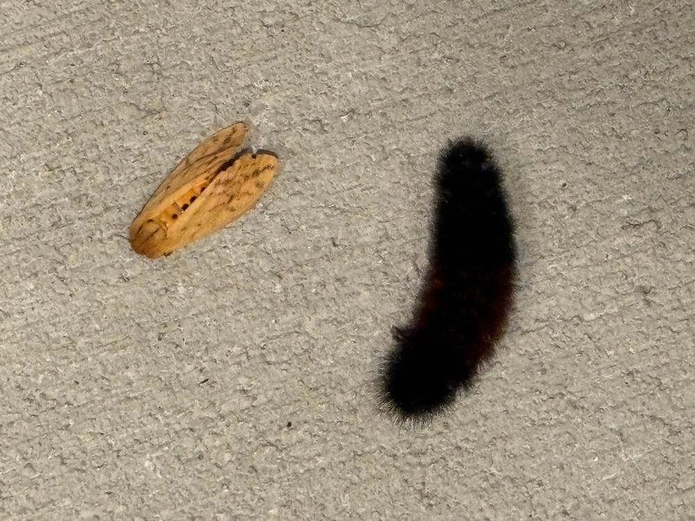
Reposted by Jeff Frame
raywolf.bsky.social
The Isabella Tiger Moth (Pyrrharctia Isabella) and its larval form, the wooly bear caterpillar. Contrary to popular belief by some in the US, there is no correlation between the color of wooly bear bands (bands may be black or rust colored) and subsequent winter weather.