


Remote Sensing post👇
An interesting paper on optimizing the EVI (Enhanced Vegetation Index). 🌐🍁
#RemoteSensing #EnvironmentalMonitoring #PlanetScope #EO #SatelliteImagery #Forestry #GIS #EVI #VegetationIndex #NDVI #optimization
Many thanks to
@rvnfxri.bsky.social
and
@sajadsayadi.bsky.social
An interesting paper on optimizing the EVI (Enhanced Vegetation Index). 🌐🍁
#RemoteSensing #EnvironmentalMonitoring #PlanetScope #EO #SatelliteImagery #Forestry #GIS #EVI #VegetationIndex #NDVI #optimization
Many thanks to
@rvnfxri.bsky.social
and
@sajadsayadi.bsky.social

Sajad Sayadi
Classic NDVI can be fuzzy over bright soils and sparse canopies. We re-parameterized EVI with PSO for semi-arid mountains on Sentinel-2.
Have you tried scene-specific EVI tuning?
#RemoteSensing #EVI #Vegetation #Indexes #PSO #Sentinel2
See more details here👇 doi.org/10.1109/Metr...
Classic NDVI can be fuzzy over bright soils and sparse canopies. We re-parameterized EVI with PSO for semi-arid mountains on Sentinel-2.
Have you tried scene-specific EVI tuning?
#RemoteSensing #EVI #Vegetation #Indexes #PSO #Sentinel2
See more details here👇 doi.org/10.1109/Metr...

October 30, 2025 at 1:53 PM
Everybody can reply
1 reposts
7 likes

Congrats to #Silva21 MSc student, Spencer Shields on his newest publication in the Science of #RemoteSensing!
Spencer explored all the ways #PlanetScope #CubeSats are used for forest monitoring & has summarized his findings in this comprehensive review! 👏
@forestry.ubc.ca @alexisachim.bsky.social
Spencer explored all the ways #PlanetScope #CubeSats are used for forest monitoring & has summarized his findings in this comprehensive review! 👏
@forestry.ubc.ca @alexisachim.bsky.social

📣NEW PAPER 📣A review of PlanetScope CubeSats for forest monitoring
✍️: Shields, Coops, Achim (@alexisachim.bsky.social), Hamelin, Mulverhill
📖: Science of Remote Sensing
doi.org/10.1016/j.sr...
#planetScope #forestry #highresolution #nearrealtime #multispectral #IRSSlab #UBCForestry
✍️: Shields, Coops, Achim (@alexisachim.bsky.social), Hamelin, Mulverhill
📖: Science of Remote Sensing
doi.org/10.1016/j.sr...
#planetScope #forestry #highresolution #nearrealtime #multispectral #IRSSlab #UBCForestry

October 25, 2025 at 7:31 PM
Everybody can reply
3 likes

Our analyses of the Qutayfah and Dhumair mass graves consisted of more than 500 images (likely much higher when you count the use of streaming tiles) and the overwhelming majority were PlanetScope.
October 22, 2025 at 12:21 PM
Everybody can reply
2 likes

"Results of the morning attack on LLC "Gazprom Neftekhim Salavat", on low-quality PlanetScope satellite images you can see the ELOU AVT-6 unit burning
Coordinates: 53.4061382113572, 55.902677003695715"
Coordinates: 53.4061382113572, 55.902677003695715"

September 24, 2025 at 7:18 PM
Everybody can reply
1 reposts
8 likes

Update on the town of Al-Mughraqa in central Gaza: Looking at PlanetScope imagery from Planet Labs, we can see that as much as 94% of the town has now been destroyed. Of the hundreds of buildings in the town, very few remain standing and essentially all of the orchards have been destroyed.

October 21, 2024 at 7:31 PM
Everybody can reply
1 reposts
2 likes
Just for awareness of the area around Nasser Hospital and central/northern Khan Yunis, there's some partial @planet.com SkySat from yesterday showing an IDF outpost about 2.5km NE of the hospital and the heavy destruction that's taken place since June.
Most recent SkySat over Nasser was August 4.
Most recent SkySat over Nasser was August 4.

August 25, 2025 at 6:27 PM
Everybody can reply
6 reposts
8 likes
Yes, the very high resolution imagery were key in confirming small details. But the near-daily cadence of PlanetScope enabled us to identify start and stop dates of activity, create vector datasets tracking the pace of reopening trenches at Qutayfah, as well as filling of new ones at Dhumair.
October 22, 2025 at 12:21 PM
Everybody can reply
1 likes

Alex Melancon assesses the usefulness of ICEYE X band #SAR data in combination with C-band #Sentinel 1 and optical Sentinel 2 and #PlanetScope data for #flood mapping.
X band is useful but the more susceptible to wind interference given the shorter wavelength
#AGU24
X band is useful but the more susceptible to wind interference given the shorter wavelength
#AGU24

December 11, 2024 at 6:38 PM
Everybody can reply
1 reposts
2 likes

Frontal degradation (130 m retreat) and rapid calving observed at a lake-terminating Drang Drung Glacier in Ladakh between 2023 and 2025 🧊📉 from high-resolution PlanetScope imagery.
#EarthObservation #Cryosphere #Transhimalaya
#EarthObservation #Cryosphere #Transhimalaya
June 11, 2025 at 12:46 AM
Everybody can reply
2 likes
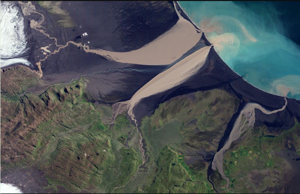
Two lovely oxbow lakes with two perfect chute channels slicing through the point bars. Río Beni, Bolivia. Screenshot of PlanetScope data by @planet.com 🧪
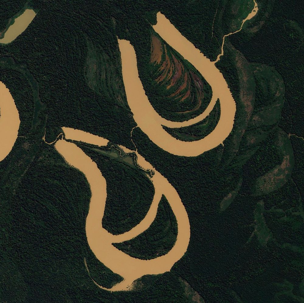
June 29, 2025 at 9:48 PM
Everybody can reply
6 reposts
64 likes

Saurabh Kaushik, Lalit Maurya, Elizabeth Tellman, ZhiJie Zhang
Assessing the value of Geo-Foundational Models for Flood Inundation Mapping: Benchmarking models for Sentinel-1, Sentinel-2, and Planetscope for end-users
https://arxiv.org/abs/2511.01990
Assessing the value of Geo-Foundational Models for Flood Inundation Mapping: Benchmarking models for Sentinel-1, Sentinel-2, and Planetscope for end-users
https://arxiv.org/abs/2511.01990
November 5, 2025 at 8:47 AM
Everybody can reply
🇷🇺Med Sea Flotilla🇷🇺
Planetscope Scene (3m) from 13 November 2024
The Admiral Grigorovich is back in port after an extended patrol. Along with her are the Admiral Gorshkov, Novorossiysk (Kilo class) and oiler Yelnya
Planetscope Scene (3m) from 13 November 2024
The Admiral Grigorovich is back in port after an extended patrol. Along with her are the Admiral Gorshkov, Novorossiysk (Kilo class) and oiler Yelnya

November 14, 2024 at 4:25 PM
Everybody can reply
6 reposts
35 likes

That's what I spent my morning on :) First PlanetScope over the area since November 1!
Left: rgb, right: false color
Left: rgb, right: false color


February 9, 2024 at 9:36 PM
Everybody can reply
3 reposts
8 likes
Under the agreement, #DLR and German researchers will have access to PlanetScope products, including nearly daily imagery of Earth’s landmass at approximately three-meter resolution.
#GermanSpaceAgency #EO
spacenews.com/planet-signs...
#GermanSpaceAgency #EO
spacenews.com/planet-signs...
Planet signs three-year DLR contract
Planet Labs Germany GmbH announced a contract to provide Earth-observation data and services to the German Space Agency DLR.
spacenews.com
September 16, 2024 at 8:08 PM
Everybody can reply
Quick geolocation by @annonemo.bsky.social of the deadly IDF strike on journalists in northern Gaza today.
While it's not clear where the journalists were filming before getting into the car, the location of the strike here is more than 3km from the border and IDF outpost constructed near it.
While it's not clear where the journalists were filming before getting into the car, the location of the strike here is more than 3km from the border and IDF outpost constructed near it.

March 15, 2025 at 4:26 PM
Everybody can reply
7 reposts
1 quotes
20 likes
🇷🇺Med Sea Flotilla🇷🇺
Spotted on Sentinel 2 and confirmed on PlanetScope Scene (29 May 2025)
Admiral Grigorovich is back in the anchorage in Tartus
Spotted on Sentinel 2 and confirmed on PlanetScope Scene (29 May 2025)
Admiral Grigorovich is back in the anchorage in Tartus

May 29, 2025 at 11:17 PM
Everybody can reply
5 reposts
25 likes

This area has so many pre-existing landslides that it will be really important to pay close attention when mapping the co-seismic failures. Some areas that look quite dramatic post-earthquake look... less dramatic when compared with the pre-earthquake imagery (3 April vs. 4 March PlanetScope images)


April 3, 2024 at 9:20 AM
Everybody can reply
1 likes
Caught by Planetscope:
https://www.planet.com/stories/brief-snow-on-mount-fuji-xHPkbZnHg
https://www.planet.com/stories/brief-snow-on-mount-fuji-xHPkbZnHg
November 18, 2024 at 11:42 PM
Everybody can reply
1 reposts
A few months ago, a leading figure in the commercial satellite biz, who did not work for Planet, told me that PlanetScope imagery is the most underused dataset in remote sensing. Consider me a cosigner. Here's why:
October 22, 2025 at 12:21 PM
Everybody can reply
1 likes
Yes! I would love to work for them. I’ve even used PlanetScope images in my academic research. I’ve applied a few times but haven’t gotten an interview with them yet.
May 3, 2023 at 3:53 AM
Everybody can reply
4 likes
Nearly all #EarthObservation-based #cropland maps across #SubSaharanAfrica include fallows in their cropland definition:
🛰️mapped cropland ≠ actively used cropland🌽
We used @Climateforest #PlanetScopenetScope#timeseriesmeseries to map active cropland and short fallows 👇
🛰️mapped cropland ≠ actively used cropland🌽
We used @Climateforest #PlanetScopenetScope#timeseriesmeseries to map active cropland and short fallows 👇

January 3, 2025 at 12:59 PM
Everybody can reply
1 likes
November 4 PlanetScope imagery from Planet Labs shows what appears to be mass demolitions in northern Gaza's Jabaliya neighborhood, not unlike what we've seen elsewhere.
In particular, many buildings in the area of 31.5317, 34.4958 near Jabaliya's main market appear to be destroyed.
In particular, many buildings in the area of 31.5317, 34.4958 near Jabaliya's main market appear to be destroyed.


November 4, 2024 at 7:09 PM
Everybody can reply
17 reposts
19 likes

Did you know we can see the fingerprints of rip currents from space? Well, we can now! Stop by our #AGU24 poster Monday morning to hear about the dataset we created using six years of PlanetScope imagery, which includes over 2,000 #CoastSat mapped images from three sites, and see what we learned :)

December 6, 2024 at 2:15 AM
Everybody can reply
1 reposts
4 likes

Last year it was Canada. This year it's Brazil.
https://www.reuters.com/world/americas/continent-ablaze-south-america-surpasses-record-fires-2024-09-12/
https://www.reuters.com/world/americas/continent-ablaze-south-america-surpasses-record-fires-2024-09-12/

September 19, 2024 at 4:28 PM
Everybody can reply
2 likes

Israel destroys Iranian refueling plane in Mashhad. 747 seems OK 🛰️📷 via Planet Labs (Skysat and Planetscope comparison)
www.nytimes.com/live/2025/06...
www.nytimes.com/live/2025/06...


June 16, 2025 at 2:53 PM
Everybody can reply
6 reposts
1 quotes
63 likes