


#NewBlogAlert 🌍
#Foodinsecurity remains a key challenge, with 733 mn people facing hunger in 2023. TGI's #GIFS Challenge is driving use of #geospatialinnovation to optimize agriculture. Read the full blog to learn more tinyurl.com/mu7u69ss
@thenadinesa.bsky.social @thatrachel.bsky.social
#Foodinsecurity remains a key challenge, with 733 mn people facing hunger in 2023. TGI's #GIFS Challenge is driving use of #geospatialinnovation to optimize agriculture. Read the full blog to learn more tinyurl.com/mu7u69ss
@thenadinesa.bsky.social @thatrachel.bsky.social
How Can Geospatial Innovation Promote Sustainable Agricultural Land Management?
TGI's second workshop on Geospatial Innovation for Food Security Challenge brought together experts to explore how technology can empower farmers to manage land more efficiently, make smarter decisions, and adopt sustainable practices.
tinyurl.com
March 5, 2025 at 6:06 PM
#NewBlogAlert 🌍
#Foodinsecurity remains a key challenge, with 733 mn people facing hunger in 2023. TGI's #GIFS Challenge is driving use of #geospatialinnovation to optimize agriculture. Read the full blog to learn more tinyurl.com/mu7u69ss
@thenadinesa.bsky.social @thatrachel.bsky.social
#Foodinsecurity remains a key challenge, with 733 mn people facing hunger in 2023. TGI's #GIFS Challenge is driving use of #geospatialinnovation to optimize agriculture. Read the full blog to learn more tinyurl.com/mu7u69ss
@thenadinesa.bsky.social @thatrachel.bsky.social
#ESIP Meeting starts tomorrow! Join Marge Cole and Rachel Opitz from #TGI as they present the #GeospatialInnovation for #FoodSecurity (#GIFS) program on Jan 24, 11:00 AM EST @thenadinesa.bsky.social
Registr: https://tinyurl.com/y2tusf6d
Registr: https://tinyurl.com/y2tusf6d

2025 January ESIP Meeting Schedule
tinyurl.com
January 20, 2025 at 5:33 PM
#ESIP Meeting starts tomorrow! Join Marge Cole and Rachel Opitz from #TGI as they present the #GeospatialInnovation for #FoodSecurity (#GIFS) program on Jan 24, 11:00 AM EST @thenadinesa.bsky.social
Registr: https://tinyurl.com/y2tusf6d
Registr: https://tinyurl.com/y2tusf6d

💻🗺️ Just mapped the 2D & 3D land cover of France 🇫🇷 using R, #ESAWorldCover data ! 🏔️✨
Shoutout to #rayshader and my mentor 👇 for helping me visualize the beauty of 🇫🇷's forests, grasslands, & urban areas! 🌲🌾🏙️
#LandCoverMapping #GeospatialInnovation #Dataviz #RGeek #30DayMapChallenge #Europe #France
Shoutout to #rayshader and my mentor 👇 for helping me visualize the beauty of 🇫🇷's forests, grasslands, & urban areas! 🌲🌾🏙️
#LandCoverMapping #GeospatialInnovation #Dataviz #RGeek #30DayMapChallenge #Europe #France


November 18, 2024 at 8:20 PM
💻🗺️ Just mapped the 2D & 3D land cover of France 🇫🇷 using R, #ESAWorldCover data ! 🏔️✨
Shoutout to #rayshader and my mentor 👇 for helping me visualize the beauty of 🇫🇷's forests, grasslands, & urban areas! 🌲🌾🏙️
#LandCoverMapping #GeospatialInnovation #Dataviz #RGeek #30DayMapChallenge #Europe #France
Shoutout to #rayshader and my mentor 👇 for helping me visualize the beauty of 🇫🇷's forests, grasslands, & urban areas! 🌲🌾🏙️
#LandCoverMapping #GeospatialInnovation #Dataviz #RGeek #30DayMapChallenge #Europe #France

www.imagine-pacific.com/2025/01/imsp...
🌀IMSPARK: Pacific-Driven Solutions with SERVIR 🌀
Labels: #ClimateAdaptation, #GeospatialInnovation, #GlobalPartnerships, #IMSPARK, #PacificResilience, #ScienceForCommunities, #SERVIR, #SustainableSolutions
🌀IMSPARK: Pacific-Driven Solutions with SERVIR 🌀
Labels: #ClimateAdaptation, #GeospatialInnovation, #GlobalPartnerships, #IMSPARK, #PacificResilience, #ScienceForCommunities, #SERVIR, #SustainableSolutions

🌀IMSPARK: Pacific-Driven Solutions with SERVIR 🌀
Social justice, Digital Equity, Poverty, Accessible Technology, Marginalized communities, Pacific, COFA, Veterans, Low-Income, Affordable housing
www.imagine-pacific.com
January 27, 2025 at 11:14 AM
www.imagine-pacific.com/2025/01/imsp...
🌀IMSPARK: Pacific-Driven Solutions with SERVIR 🌀
Labels: #ClimateAdaptation, #GeospatialInnovation, #GlobalPartnerships, #IMSPARK, #PacificResilience, #ScienceForCommunities, #SERVIR, #SustainableSolutions
🌀IMSPARK: Pacific-Driven Solutions with SERVIR 🌀
Labels: #ClimateAdaptation, #GeospatialInnovation, #GlobalPartnerships, #IMSPARK, #PacificResilience, #ScienceForCommunities, #SERVIR, #SustainableSolutions

🔥 Advancing Wildfire Resilience with Geospatial Innovation! On Jan 6, 2025, we held a workshop in Santa Barbara with experts to enhance wildfire resilience. Thanks to our partners for their support! Interested in our next workshop? Reach out! #WildfireResilience #GeospatialInnovation #ClimateAction

January 31, 2025 at 7:49 PM
🔥 Advancing Wildfire Resilience with Geospatial Innovation! On Jan 6, 2025, we held a workshop in Santa Barbara with experts to enhance wildfire resilience. Thanks to our partners for their support! Interested in our next workshop? Reach out! #WildfireResilience #GeospatialInnovation #ClimateAction
From #PrecisionAg to #ClimateResilience, #Geospatial tech is making real impact. At #TGI #GIFS Challenge Workshop, Joe Cornelius emphasized why #GeospatialInnovation is key to #FoodSecurity.
Read 👉 tinyurl.com/2emx3xew @thenadinesa.bsky.social @thatrachel.bsky.social
Read 👉 tinyurl.com/2emx3xew @thenadinesa.bsky.social @thatrachel.bsky.social

Joe Cornelius Advocates Geospatial Innovation to Tackle Food Insecurity
At TGI's second GIFS workshop, Joe Cornelius, CEO of Gates Agricultural Innovations, delivered a powerful keynote on transformative potential of geospatial innovation in addressing food security challenges.
tinyurl.com
February 26, 2025 at 10:09 PM
From #PrecisionAg to #ClimateResilience, #Geospatial tech is making real impact. At #TGI #GIFS Challenge Workshop, Joe Cornelius emphasized why #GeospatialInnovation is key to #FoodSecurity.
Read 👉 tinyurl.com/2emx3xew @thenadinesa.bsky.social @thatrachel.bsky.social
Read 👉 tinyurl.com/2emx3xew @thenadinesa.bsky.social @thatrachel.bsky.social

Dakota County is set to enhance regional data sharing with a new contract that promises quarterly geospatial datasets and a boost in collaboration starting in 2026!
Click to read more!
#DakotaCounty #MN #DakotaCountyGIS #CitizenPortal #GeospatialInnovation #LocalGovCollaboration
Click to read more!
#DakotaCounty #MN #DakotaCountyGIS #CitizenPortal #GeospatialInnovation #LocalGovCollaboration

Dakota County authorizes contract with Metropolitan Council for geospatial data
The Dakota County Board of Commissioners authorized the county to execute a contract with the Metropolitan Council for Metro GIS services beginning Jan. 1, 2026. Under the agreement, Dakota County will provide four datasets quarterly and receive $4,000 annually.
citizenportal.ai
November 5, 2025 at 10:23 AM
Dakota County is set to enhance regional data sharing with a new contract that promises quarterly geospatial datasets and a boost in collaboration starting in 2026!
Click to read more!
#DakotaCounty #MN #DakotaCountyGIS #CitizenPortal #GeospatialInnovation #LocalGovCollaboration
Click to read more!
#DakotaCounty #MN #DakotaCountyGIS #CitizenPortal #GeospatialInnovation #LocalGovCollaboration

La NASA repère un "point noir" gigantesque dans le Sahara: un champ volcanique de 44 000 km², vestige d’éruptions lentes et anciennes.
cadenaser.com/nacional/hyp...
#Space #Science #EarthObservation #Sahara #VolcanicField #HarujVolcano #GeospatialInnovation
cadenaser.com/nacional/hyp...
#Space #Science #EarthObservation #Sahara #VolcanicField #HarujVolcano #GeospatialInnovation
https://cadenaser.com/nacional/hype/2025/05/26/la-nasa‑encontre‑un‑mysterieux‑point‑noir‑en‑le‑sahara‑tient‑le‑taille‑de‑extremadura
July 29, 2025 at 6:54 PM
La NASA repère un "point noir" gigantesque dans le Sahara: un champ volcanique de 44 000 km², vestige d’éruptions lentes et anciennes.
cadenaser.com/nacional/hyp...
#Space #Science #EarthObservation #Sahara #VolcanicField #HarujVolcano #GeospatialInnovation
cadenaser.com/nacional/hyp...
#Space #Science #EarthObservation #Sahara #VolcanicField #HarujVolcano #GeospatialInnovation
Panel Discussion: How #geospatialtechnologies can help reduce #foodwaste & improve #nutrition
Date: Feb 6
Details 👉 https://www.taylorgeospatial.org/foodsecuritychallenge/workshop2
#TGIEvent #GIFS #GeospatialInnovation #FoodSecurity @thatrachel.bsky.social @thenadinesa.bsky.social
Date: Feb 6
Details 👉 https://www.taylorgeospatial.org/foodsecuritychallenge/workshop2
#TGIEvent #GIFS #GeospatialInnovation #FoodSecurity @thatrachel.bsky.social @thenadinesa.bsky.social

January 28, 2025 at 6:07 PM
Panel Discussion: How #geospatialtechnologies can help reduce #foodwaste & improve #nutrition
Date: Feb 6
Details 👉 https://www.taylorgeospatial.org/foodsecuritychallenge/workshop2
#TGIEvent #GIFS #GeospatialInnovation #FoodSecurity @thatrachel.bsky.social @thenadinesa.bsky.social
Date: Feb 6
Details 👉 https://www.taylorgeospatial.org/foodsecuritychallenge/workshop2
#TGIEvent #GIFS #GeospatialInnovation #FoodSecurity @thatrachel.bsky.social @thenadinesa.bsky.social
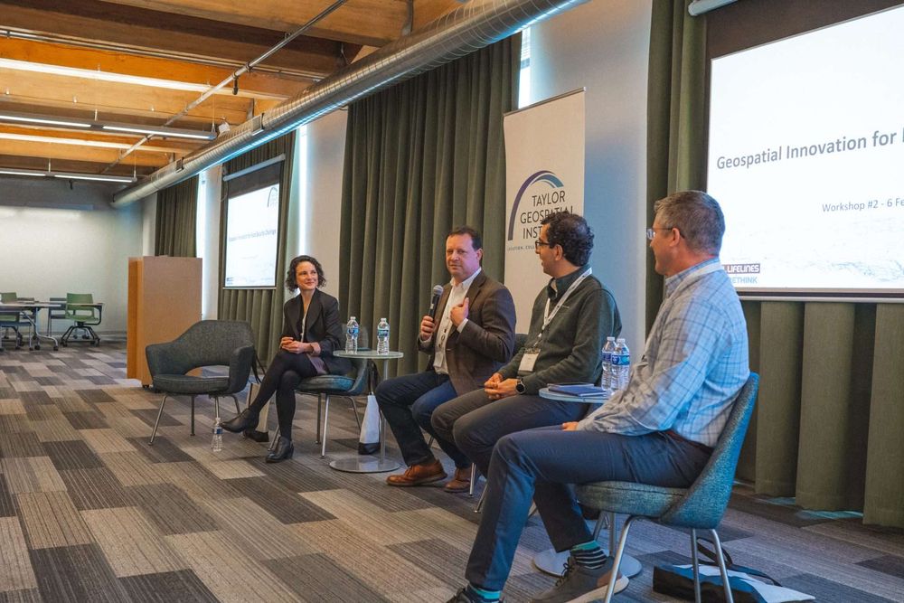
#TGI #GIFS Workshop Feb 6 Panel on #Geospatial & #sustainableag highlighted challenges like tech #affordability and #integration for farmers. Key takeaway: #Innovation must fit into the system for users to adopt
#GeospatialInnovation #TGIEvent @thatrachel.bsky.social @thenadinesa.bsky.social
#GeospatialInnovation #TGIEvent @thatrachel.bsky.social @thenadinesa.bsky.social

February 11, 2025 at 6:16 PM
#TGI #GIFS Workshop Feb 6 Panel on #Geospatial & #sustainableag highlighted challenges like tech #affordability and #integration for farmers. Key takeaway: #Innovation must fit into the system for users to adopt
#GeospatialInnovation #TGIEvent @thatrachel.bsky.social @thenadinesa.bsky.social
#GeospatialInnovation #TGIEvent @thatrachel.bsky.social @thenadinesa.bsky.social