


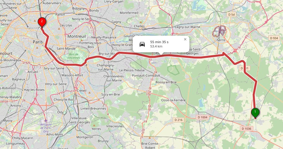


I used the {openrouteservice} R package to calculate the isochrones - i.e. the area that is reachable within a given time period.
December 4, 2025 at 12:22 PM
I used the {openrouteservice} R package to calculate the isochrones - i.e. the area that is reachable within a given time period.

Public transport isn't currently an option in the openrouteservice API (I guess they'd have to pull in a lot of scheduling data from different providers as well as the route data from OpenStreetMap so it's much more complicated)
But I would have loved to also compare buses/trams
But I would have loved to also compare buses/trams
November 29, 2025 at 12:49 PM
Public transport isn't currently an option in the openrouteservice API (I guess they'd have to pull in a lot of scheduling data from different providers as well as the route data from OpenStreetMap so it's much more complicated)
But I would have loved to also compare buses/trams
But I would have loved to also compare buses/trams

𝗢𝗽𝗲𝗻𝗿𝗼𝘂𝘁𝗲 𝘀𝗲𝗿𝘃𝗶𝗰𝗲, 𝗮𝗻 𝗼𝗽𝗲𝗻 𝘀𝗼𝘂𝗿𝗰𝗲 𝗮𝗹𝘁𝗲𝗿𝗻𝗮𝘁𝗶𝘃𝗲 𝘁𝗼 𝗚𝗼𝗼𝗴𝗹𝗲 𝗺𝗮𝗽 𝗔𝗣𝗜
The openrouteservice API consumes user-generated and collaboratively collected free geographic da ...
https://thewhale.cc/posts/openroute-service-an-open-source-alternative-to-google-map-api
#Map #OpenSource #API
The openrouteservice API consumes user-generated and collaboratively collected free geographic da ...
https://thewhale.cc/posts/openroute-service-an-open-source-alternative-to-google-map-api
#Map #OpenSource #API

Openroute service, an open source alternative to Google map API
The openrouteservice API consumes user-generated and collaboratively collected free geographic data, directly from OpenStreetMap.
thewhale.cc
November 4, 2025 at 4:00 PM
𝗢𝗽𝗲𝗻𝗿𝗼𝘂𝘁𝗲 𝘀𝗲𝗿𝘃𝗶𝗰𝗲, 𝗮𝗻 𝗼𝗽𝗲𝗻 𝘀𝗼𝘂𝗿𝗰𝗲 𝗮𝗹𝘁𝗲𝗿𝗻𝗮𝘁𝗶𝘃𝗲 𝘁𝗼 𝗚𝗼𝗼𝗴𝗹𝗲 𝗺𝗮𝗽 𝗔𝗣𝗜
The openrouteservice API consumes user-generated and collaboratively collected free geographic da ...
https://thewhale.cc/posts/openroute-service-an-open-source-alternative-to-google-map-api
#Map #OpenSource #API
The openrouteservice API consumes user-generated and collaboratively collected free geographic da ...
https://thewhale.cc/posts/openroute-service-an-open-source-alternative-to-google-map-api
#Map #OpenSource #API

𝗛𝗲𝗶𝗚𝗜𝗧 𝗮𝘁 𝗦𝘁𝗮𝘁𝗲 𝗢𝗳 𝗧𝗵𝗲 𝗠𝗮𝗽 𝗪𝗼𝗿𝗹𝗱
From Oct 3-5, State of the Map World, the annual event for all mappers and OpenStreetMap users, takes place in Manila. HeiGIT will contribute with three sessions on OSM data for routing, openrouteservice and the current state of OSM.
🔍 heigit.org/events/heigi...
From Oct 3-5, State of the Map World, the annual event for all mappers and OpenStreetMap users, takes place in Manila. HeiGIT will contribute with three sessions on OSM data for routing, openrouteservice and the current state of OSM.
🔍 heigit.org/events/heigi...

September 26, 2025 at 8:15 AM
𝗛𝗲𝗶𝗚𝗜𝗧 𝗮𝘁 𝗦𝘁𝗮𝘁𝗲 𝗢𝗳 𝗧𝗵𝗲 𝗠𝗮𝗽 𝗪𝗼𝗿𝗹𝗱
From Oct 3-5, State of the Map World, the annual event for all mappers and OpenStreetMap users, takes place in Manila. HeiGIT will contribute with three sessions on OSM data for routing, openrouteservice and the current state of OSM.
🔍 heigit.org/events/heigi...
From Oct 3-5, State of the Map World, the annual event for all mappers and OpenStreetMap users, takes place in Manila. HeiGIT will contribute with three sessions on OSM data for routing, openrouteservice and the current state of OSM.
🔍 heigit.org/events/heigi...
𝐨𝐩𝐞𝐧𝐫𝐨𝐮𝐭𝐞𝐬𝐞𝐫𝐯𝐢𝐜𝐞 𝐮𝐬𝐞-𝐜𝐚𝐬𝐞: 𝐞𝗻𝗵𝗮𝗻𝗰𝗶𝗻𝗴 𝐬𝘂𝘀𝘁𝗮𝗶𝗻𝗮𝗯𝗹𝗲 𝐭𝗿𝗮𝘃𝗲𝗹 𝗶𝗻 𝐬𝗺𝗮𝗹𝗹 𝐜𝗶𝘁𝗶𝗲𝘀 𝗮𝗻𝗱 𝐨𝘂𝘁𝗲𝗿 𝐦𝗲𝘁𝗿𝗼𝗽𝗼𝗹𝗶𝘁𝗮𝗻 𝐚𝗿𝗲𝗮𝐬 🚶🚲
The ENHANCE project uses mapping, behavior research & simulations to design sustainable & inclusive mobility in smaller communities.
Read more: heigit.org/openrouteser...
#research #mobility
The ENHANCE project uses mapping, behavior research & simulations to design sustainable & inclusive mobility in smaller communities.
Read more: heigit.org/openrouteser...
#research #mobility

September 17, 2025 at 7:45 AM
𝐨𝐩𝐞𝐧𝐫𝐨𝐮𝐭𝐞𝐬𝐞𝐫𝐯𝐢𝐜𝐞 𝐮𝐬𝐞-𝐜𝐚𝐬𝐞: 𝐞𝗻𝗵𝗮𝗻𝗰𝗶𝗻𝗴 𝐬𝘂𝘀𝘁𝗮𝗶𝗻𝗮𝗯𝗹𝗲 𝐭𝗿𝗮𝘃𝗲𝗹 𝗶𝗻 𝐬𝗺𝗮𝗹𝗹 𝐜𝗶𝘁𝗶𝗲𝘀 𝗮𝗻𝗱 𝐨𝘂𝘁𝗲𝗿 𝐦𝗲𝘁𝗿𝗼𝗽𝗼𝗹𝗶𝘁𝗮𝗻 𝐚𝗿𝗲𝗮𝐬 🚶🚲
The ENHANCE project uses mapping, behavior research & simulations to design sustainable & inclusive mobility in smaller communities.
Read more: heigit.org/openrouteser...
#research #mobility
The ENHANCE project uses mapping, behavior research & simulations to design sustainable & inclusive mobility in smaller communities.
Read more: heigit.org/openrouteser...
#research #mobility

KomGIS+ integriert den Open Route Service geoobserver.de/2025/09/10/k... #ORS #OpenRouteService #KomGIS #gistribe #gischat #fossgis #foss4g #OSGeo #spatial #geospatial #gis #geo #geoObserver pls RT

September 10, 2025 at 2:02 PM
KomGIS+ integriert den Open Route Service geoobserver.de/2025/09/10/k... #ORS #OpenRouteService #KomGIS #gistribe #gischat #fossgis #foss4g #OSGeo #spatial #geospatial #gis #geo #geoObserver pls RT

If you find OpenStreetMap a bit difficult to plan off-road routes, try OpenRouteService
OpenRouteService (ORS) is an open source route planner service that leverages OpenStreetMap data to provide a variety of routing and spatial analysis services. It actually uses a forked and modified version […]
OpenRouteService (ORS) is an open source route planner service that leverages OpenStreetMap data to provide a variety of routing and spatial analysis services. It actually uses a forked and modified version […]
Original post on mastodon.social
mastodon.social
August 4, 2025 at 6:01 AM
If you find OpenStreetMap a bit difficult to plan off-road routes, try OpenRouteService
OpenRouteService (ORS) is an open source route planner service that leverages OpenStreetMap data to provide a variety of routing and spatial analysis services. It actually uses a forked and modified version […]
OpenRouteService (ORS) is an open source route planner service that leverages OpenStreetMap data to provide a variety of routing and spatial analysis services. It actually uses a forked and modified version […]

If you find OpenStreetMap a bit difficult to plan off-road routes, try OpenRouteService
See gadgeteer.co.za/if-you-find-...
#navigation #opensource #OpenStreetMap #technology
See gadgeteer.co.za/if-you-find-...
#navigation #opensource #OpenStreetMap #technology

If you find OpenStreetMap a bit difficult to plan off-road routes, try OpenRouteService
OpenRouteService (ORS) is an open source route planner service that leverages OpenStreetMap data to provide a variety of routing and spatial analysis
gadgeteer.co.za
August 4, 2025 at 6:01 AM
If you find OpenStreetMap a bit difficult to plan off-road routes, try OpenRouteService
See gadgeteer.co.za/if-you-find-...
#navigation #opensource #OpenStreetMap #technology
See gadgeteer.co.za/if-you-find-...
#navigation #opensource #OpenStreetMap #technology

If you find OpenStreetMap a bit difficult to plan off-road routes, try OpenRouteService
See gadgeteer.co.za/if-you-find-...
#navigation #opensource #OpenStreetMap #technology
See gadgeteer.co.za/if-you-find-...
#navigation #opensource #OpenStreetMap #technology

If you find OpenStreetMap a bit difficult to plan off-road routes, try OpenRouteService
OpenRouteService (ORS) is an open source route planner service that leverages OpenStreetMap data to provide a variety of routing and spatial analysis
gadgeteer.co.za
August 4, 2025 at 6:01 AM
If you find OpenStreetMap a bit difficult to plan off-road routes, try OpenRouteService
See gadgeteer.co.za/if-you-find-...
#navigation #opensource #OpenStreetMap #technology
See gadgeteer.co.za/if-you-find-...
#navigation #opensource #OpenStreetMap #technology
QGIS-Tipp: Plugin ORSTools v.2.0.1 geoobserver.de/2025/07/25/q... #qgis #plugin #switch2qgis #ors #openrouteservice #gistribe #gischat #fossgis #foss4g #OSGeo #spatial #geospatial #opensource #gis #geo #geoObserver pls RT

July 25, 2025 at 12:05 PM
QGIS-Tipp: Plugin ORSTools v.2.0.1 geoobserver.de/2025/07/25/q... #qgis #plugin #switch2qgis #ors #openrouteservice #gistribe #gischat #fossgis #foss4g #OSGeo #spatial #geospatial #opensource #gis #geo #geoObserver pls RT
𝗨𝘀𝗲-𝗖𝗮𝘀𝗲: 𝗠𝗲𝗮𝘀𝘂𝗿𝗶𝗻𝗴 𝗰𝗶𝘁𝘆 𝘄𝗮𝗹𝗸𝗮𝗯𝗶𝗹𝗶𝘁𝘆 𝘄𝗶𝘁𝗵 𝗼𝗽𝗲𝗻𝗿𝗼𝘂𝘁𝗲𝘀𝗲𝗿𝘃𝗶𝗰𝗲👣
A recent study by the DC Office of the Chief Technology Officer explores how well residents in Washington, DC can access essential public resources by foot. The isochrones analysis was based openrouteservice.
heigit.org/use-case-mea...
A recent study by the DC Office of the Chief Technology Officer explores how well residents in Washington, DC can access essential public resources by foot. The isochrones analysis was based openrouteservice.
heigit.org/use-case-mea...
July 21, 2025 at 12:34 PM
𝗨𝘀𝗲-𝗖𝗮𝘀𝗲: 𝗠𝗲𝗮𝘀𝘂𝗿𝗶𝗻𝗴 𝗰𝗶𝘁𝘆 𝘄𝗮𝗹𝗸𝗮𝗯𝗶𝗹𝗶𝘁𝘆 𝘄𝗶𝘁𝗵 𝗼𝗽𝗲𝗻𝗿𝗼𝘂𝘁𝗲𝘀𝗲𝗿𝘃𝗶𝗰𝗲👣
A recent study by the DC Office of the Chief Technology Officer explores how well residents in Washington, DC can access essential public resources by foot. The isochrones analysis was based openrouteservice.
heigit.org/use-case-mea...
A recent study by the DC Office of the Chief Technology Officer explores how well residents in Washington, DC can access essential public resources by foot. The isochrones analysis was based openrouteservice.
heigit.org/use-case-mea...
📱🗺️ 𝗤𝗚𝗜𝗦 users can now integrate 𝗼𝗽𝗲𝗻𝗿𝗼𝘂𝘁𝗲𝘀𝗲𝗿𝘃𝗶𝗰𝗲 also in the mobile app 𝗤𝗙𝗶𝗲𝗹𝗱.
With a new plugin by HeiGIT & OPENGIS.ch, all main functions of openrouteservice can be used in QField to generate routes for different means of transport profiles.
Find the plugin here: github.com/GIScience/qf...
#QGIS
With a new plugin by HeiGIT & OPENGIS.ch, all main functions of openrouteservice can be used in QField to generate routes for different means of transport profiles.
Find the plugin here: github.com/GIScience/qf...
#QGIS
July 18, 2025 at 7:46 AM
📱🗺️ 𝗤𝗚𝗜𝗦 users can now integrate 𝗼𝗽𝗲𝗻𝗿𝗼𝘂𝘁𝗲𝘀𝗲𝗿𝘃𝗶𝗰𝗲 also in the mobile app 𝗤𝗙𝗶𝗲𝗹𝗱.
With a new plugin by HeiGIT & OPENGIS.ch, all main functions of openrouteservice can be used in QField to generate routes for different means of transport profiles.
Find the plugin here: github.com/GIScience/qf...
#QGIS
With a new plugin by HeiGIT & OPENGIS.ch, all main functions of openrouteservice can be used in QField to generate routes for different means of transport profiles.
Find the plugin here: github.com/GIScience/qf...
#QGIS

@heigit.org Ihr beweist, dass Technologie für Umwelt und Gesellschaft ein echter Game-Changer sein kann. Herzlichen Dank – ihr seid wirklich spitze! 🌍❤️ Eure Tools wie openrouteservice oder die HEAL-App sind nicht nur innovativ, sondern auch richtig nützlich. (Und ganz nebenbei: Danke für die API! 😉)
About – HeiGIT
heigit.org
July 13, 2025 at 2:27 PM
@heigit.org Ihr beweist, dass Technologie für Umwelt und Gesellschaft ein echter Game-Changer sein kann. Herzlichen Dank – ihr seid wirklich spitze! 🌍❤️ Eure Tools wie openrouteservice oder die HEAL-App sind nicht nur innovativ, sondern auch richtig nützlich. (Und ganz nebenbei: Danke für die API! 😉)
@tobwen.bsky.social it should actually be possible to connect to localhost. Please ask any technical questions in the ORS forum, the openrouteservice team and community will help you solve the issue: ask.openrouteservice.org
June 25, 2025 at 11:58 AM
@tobwen.bsky.social it should actually be possible to connect to localhost. Please ask any technical questions in the ORS forum, the openrouteservice team and community will help you solve the issue: ask.openrouteservice.org
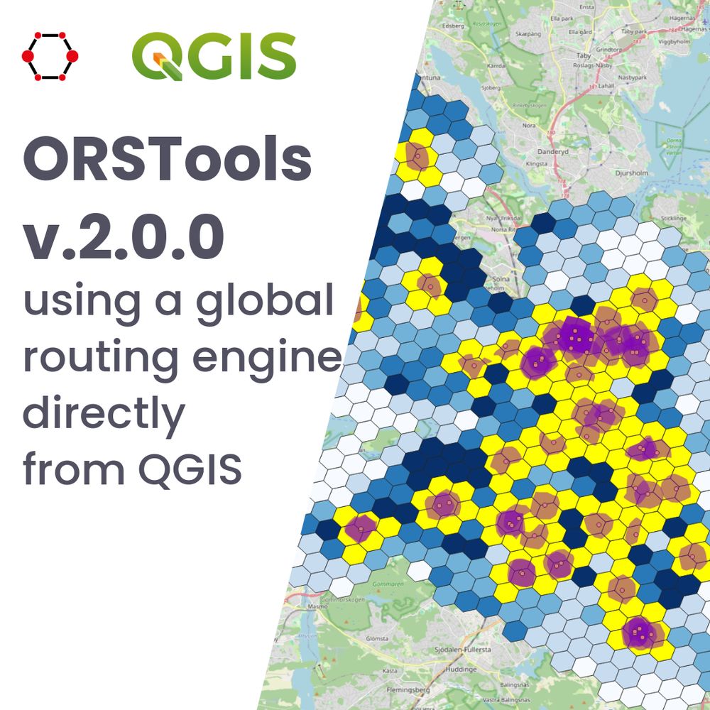
𝗥𝗲𝗹𝗲𝗮𝘀𝗲 𝗼𝗳 𝗤𝗚𝗜𝗦 𝗽𝗹𝘂𝗴𝗶𝗻 𝗢𝗥𝗦𝗧𝗼𝗼𝗹𝘀 𝘃.𝟮.𝟬.𝟬🗺️
ORSTools integrates #openrouteservice directly in #QGIS. This new version brings significant improvements, as full compatibility with new QGIS updates & the possibility to drag-and-drop vertex markers:
heigit.org/release-of-q...
ORSTools integrates #openrouteservice directly in #QGIS. This new version brings significant improvements, as full compatibility with new QGIS updates & the possibility to drag-and-drop vertex markers:
heigit.org/release-of-q...
June 25, 2025 at 9:23 AM
𝗥𝗲𝗹𝗲𝗮𝘀𝗲 𝗼𝗳 𝗤𝗚𝗜𝗦 𝗽𝗹𝘂𝗴𝗶𝗻 𝗢𝗥𝗦𝗧𝗼𝗼𝗹𝘀 𝘃.𝟮.𝟬.𝟬🗺️
ORSTools integrates #openrouteservice directly in #QGIS. This new version brings significant improvements, as full compatibility with new QGIS updates & the possibility to drag-and-drop vertex markers:
heigit.org/release-of-q...
ORSTools integrates #openrouteservice directly in #QGIS. This new version brings significant improvements, as full compatibility with new QGIS updates & the possibility to drag-and-drop vertex markers:
heigit.org/release-of-q...
To know how NO2 concentration might affect the population, we chose to calculate isochrones (5-minute walk) from the measurements, using #openrouteservice in a R environment. We then used #QGIS to create the final maps.
Does anyone have another approach?
#datascience #GISChat #RStats #airpollution
Does anyone have another approach?
#datascience #GISChat #RStats #airpollution

June 3, 2025 at 10:51 AM
To know how NO2 concentration might affect the population, we chose to calculate isochrones (5-minute walk) from the measurements, using #openrouteservice in a R environment. We then used #QGIS to create the final maps.
Does anyone have another approach?
#datascience #GISChat #RStats #airpollution
Does anyone have another approach?
#datascience #GISChat #RStats #airpollution
🗺️📍You are attending this year's QGIS User Conference in Norrköping, Sweden and want to learn about openrouteservice and how to implement routing with ORSTools in QGIS? We invite you to join our sessions!
Read more: heigit.org/events/heigi...
Read more: heigit.org/events/heigi...

May 21, 2025 at 9:10 AM
🗺️📍You are attending this year's QGIS User Conference in Norrköping, Sweden and want to learn about openrouteservice and how to implement routing with ORSTools in QGIS? We invite you to join our sessions!
Read more: heigit.org/events/heigi...
Read more: heigit.org/events/heigi...

This was for the June 2024 service change. By that point, MTS had estimated that its ZEBs average about 140 miles per charge. My calculations include pullin/pullout distances and intra-block deadheads using driving distance estimates from Openrouteservice.
May 7, 2025 at 7:07 PM
This was for the June 2024 service change. By that point, MTS had estimated that its ZEBs average about 140 miles per charge. My calculations include pullin/pullout distances and intra-block deadheads using driving distance estimates from Openrouteservice.
openrouteservice (ORS) is an open-source platform that uses #OpenStreetMap data to support advanced mobility and accessibility analysis.
🗺️ Try out ORS: openrouteservice.org
🗺️ Try out ORS: openrouteservice.org


May 5, 2025 at 12:43 PM
openrouteservice (ORS) is an open-source platform that uses #OpenStreetMap data to support advanced mobility and accessibility analysis.
🗺️ Try out ORS: openrouteservice.org
🗺️ Try out ORS: openrouteservice.org
🌐 Do we really need digital sovereignty—and why?
While over 80% of Europe’s digital products come from outside the EU, many are seeking Europe-based alternatives.
We help to drive this change with 𝗼𝗽𝗲𝗻𝗿𝗼𝘂𝘁𝗲𝘀𝗲𝗿𝘃𝗶𝗰𝗲 (ORS), an open platform for routing and mobility analysis:
heigit.org/open-source-...
While over 80% of Europe’s digital products come from outside the EU, many are seeking Europe-based alternatives.
We help to drive this change with 𝗼𝗽𝗲𝗻𝗿𝗼𝘂𝘁𝗲𝘀𝗲𝗿𝘃𝗶𝗰𝗲 (ORS), an open platform for routing and mobility analysis:
heigit.org/open-source-...

May 5, 2025 at 12:43 PM
🌐 Do we really need digital sovereignty—and why?
While over 80% of Europe’s digital products come from outside the EU, many are seeking Europe-based alternatives.
We help to drive this change with 𝗼𝗽𝗲𝗻𝗿𝗼𝘂𝘁𝗲𝘀𝗲𝗿𝘃𝗶𝗰𝗲 (ORS), an open platform for routing and mobility analysis:
heigit.org/open-source-...
While over 80% of Europe’s digital products come from outside the EU, many are seeking Europe-based alternatives.
We help to drive this change with 𝗼𝗽𝗲𝗻𝗿𝗼𝘂𝘁𝗲𝘀𝗲𝗿𝘃𝗶𝗰𝗲 (ORS), an open platform for routing and mobility analysis:
heigit.org/open-source-...
📍 How accessible is your neighborhood—and what does that say about who lives there?
A recent thesis uses openrouteservice (ORS), POI data & ML to estimate building-level demographics in German cities—offering insights for planning in data-scarce contexts.
#research #machinelearning
A recent thesis uses openrouteservice (ORS), POI data & ML to estimate building-level demographics in German cities—offering insights for planning in data-scarce contexts.
#research #machinelearning

April 15, 2025 at 3:30 PM
📍 How accessible is your neighborhood—and what does that say about who lives there?
A recent thesis uses openrouteservice (ORS), POI data & ML to estimate building-level demographics in German cities—offering insights for planning in data-scarce contexts.
#research #machinelearning
A recent thesis uses openrouteservice (ORS), POI data & ML to estimate building-level demographics in German cities—offering insights for planning in data-scarce contexts.
#research #machinelearning

Just published my latest coding adventure: "Roads Less Traveled"
I set up a local OpenRouteService to calculate real driving distances without expensive APIs.
medium.com/@tibeggs/roa...
This writeup's a bit of a mixed bag, but I'm enjoying getting more time to write about what I'm learning.
I set up a local OpenRouteService to calculate real driving distances without expensive APIs.
medium.com/@tibeggs/roa...
This writeup's a bit of a mixed bag, but I'm enjoying getting more time to write about what I'm learning.

Roads Less Traveled: DIY Distance Mapping Without Breaking the Bank
A lazy coder’s guide to running Open Route Service on your laptop
medium.com
March 1, 2025 at 11:08 PM
Just published my latest coding adventure: "Roads Less Traveled"
I set up a local OpenRouteService to calculate real driving distances without expensive APIs.
medium.com/@tibeggs/roa...
This writeup's a bit of a mixed bag, but I'm enjoying getting more time to write about what I'm learning.
I set up a local OpenRouteService to calculate real driving distances without expensive APIs.
medium.com/@tibeggs/roa...
This writeup's a bit of a mixed bag, but I'm enjoying getting more time to write about what I'm learning.
#openrouteservice (ORS) has been growing steadily, and we are thrilled to see how it is being used for meaningful purposes, from humanitarian logistics to sustainable transportation and beyond.
Here are some metrics on its impact in the last year ⬇️
🔗 Access ORS: openrouteservice.org
Here are some metrics on its impact in the last year ⬇️
🔗 Access ORS: openrouteservice.org


February 18, 2025 at 4:30 PM
#openrouteservice (ORS) has been growing steadily, and we are thrilled to see how it is being used for meaningful purposes, from humanitarian logistics to sustainable transportation and beyond.
Here are some metrics on its impact in the last year ⬇️
🔗 Access ORS: openrouteservice.org
Here are some metrics on its impact in the last year ⬇️
🔗 Access ORS: openrouteservice.org
openrouteservice provides open-source routing with various modes like walking, cycling, driving, wheelchair routes, and options to avoid noise and heat-stress.
Some features: isochrone-based accessibility analysis, time-distance matrices, POI search, geocoding, and multi-stop route optimization.
Some features: isochrone-based accessibility analysis, time-distance matrices, POI search, geocoding, and multi-stop route optimization.
February 17, 2025 at 8:05 AM
openrouteservice provides open-source routing with various modes like walking, cycling, driving, wheelchair routes, and options to avoid noise and heat-stress.
Some features: isochrone-based accessibility analysis, time-distance matrices, POI search, geocoding, and multi-stop route optimization.
Some features: isochrone-based accessibility analysis, time-distance matrices, POI search, geocoding, and multi-stop route optimization.