


a.s.
@wxandbiscuits.bsky.social
fire/tropical meteorologist. dogs, native plants and good food. georgia now but midwest is home. he/him/🏳️🌈. opinions my own.
Kinda wild to see increasing model support for a tropical cyclone in the western Atlantic heading into December. The Gulf has warmed back to near record levels for this time of year. Hopefully drought relief is the main impact if it materializes.


November 23, 2025 at 2:16 AM
Kinda wild to see increasing model support for a tropical cyclone in the western Atlantic heading into December. The Gulf has warmed back to near record levels for this time of year. Hopefully drought relief is the main impact if it materializes.
Melissa forecast by @pppapin.bsky.social at NHC to be a cat 4 by Monday. “Unfortunately, it is becoming increasingly likely that Melissa will become a large and dangerous hurricane by the end of the forecast period.”

October 22, 2025 at 9:13 PM
Melissa forecast by @pppapin.bsky.social at NHC to be a cat 4 by Monday. “Unfortunately, it is becoming increasingly likely that Melissa will become a large and dangerous hurricane by the end of the forecast period.”
Love seeing a confidence indicator on WPC’s rainfall forecast for Melissa. The track uncertainty has huge implications for the degree of flooding across the Dominican Republic, Haiti, Cuba, Jamaica, the Bahamas and Turks & Caicos.

October 22, 2025 at 3:13 PM
Love seeing a confidence indicator on WPC’s rainfall forecast for Melissa. The track uncertainty has huge implications for the degree of flooding across the Dominican Republic, Haiti, Cuba, Jamaica, the Bahamas and Turks & Caicos.
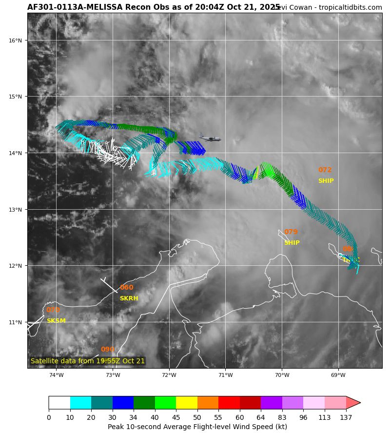
Imagine some center reformations will occur the next few days, but the Air Force is finding Melissa’s low level circulation well removed from what is occurring aloft. Hard to buy the eastern solutions at this point.
October 21, 2025 at 8:12 PM
Imagine some center reformations will occur the next few days, but the Air Force is finding Melissa’s low level circulation well removed from what is occurring aloft. Hard to buy the eastern solutions at this point.
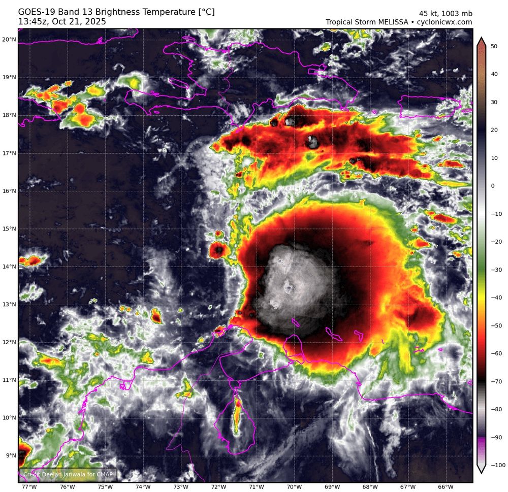
The NHC will initiate advisories on Tropical Storm Melissa at 1100 ET this morning.
October 21, 2025 at 1:57 PM
The NHC will initiate advisories on Tropical Storm Melissa at 1100 ET this morning.
Not much more clarity today, with two main camps. Faster organization would result in a northeast track and catastrophic flooding for Haiti, D.R. and Puerto Rico. The slower option would lead to #98L becoming a more intense hurricane farther west.

October 19, 2025 at 2:16 PM
Not much more clarity today, with two main camps. Faster organization would result in a northeast track and catastrophic flooding for Haiti, D.R. and Puerto Rico. The slower option would lead to #98L becoming a more intense hurricane farther west.
Sunset on Invest #98L in the tropical Atlantic reveals continued westerly shear but increased signs of organization as it moves swiftly to the west.
October 18, 2025 at 10:12 PM
Sunset on Invest #98L in the tropical Atlantic reveals continued westerly shear but increased signs of organization as it moves swiftly to the west.
Whatever track this takes will be over unusually warm water, which is especially worrying for the risk of rapid intensification and extreme rainfall in the vulnerable islands, as atmospheric conditions look to be pristine. Maps from @climatecentral.org and @drkimwood.bsky.social


October 17, 2025 at 2:53 PM
Whatever track this takes will be over unusually warm water, which is especially worrying for the risk of rapid intensification and extreme rainfall in the vulnerable islands, as atmospheric conditions look to be pristine. Maps from @climatecentral.org and @drkimwood.bsky.social
DeepMind made a decisive shift towards development and impacts to Haiti and DR next week, while the Euro ensembles were farther west, and the US ensembles are all over the place. A lot to sort out still, with the key being how fast it develops.


October 17, 2025 at 11:58 AM
DeepMind made a decisive shift towards development and impacts to Haiti and DR next week, while the Euro ensembles were farther west, and the US ensembles are all over the place. A lot to sort out still, with the key being how fast it develops.
The first impactful Caribbean hurricane of 2025 appears increasingly likely next week, but the MJO heading towards the West Pac may lead to a quieter period in the Atlantic by early November.

October 14, 2025 at 9:17 PM
The first impactful Caribbean hurricane of 2025 appears increasingly likely next week, but the MJO heading towards the West Pac may lead to a quieter period in the Atlantic by early November.
Found a gulf fritillary chrysalising on the back of the house. They love to get up under the siding after engorging all late summer on my backyard passiflora lutea. This one seems late.

October 13, 2025 at 4:59 PM
Found a gulf fritillary chrysalising on the back of the house. They love to get up under the siding after engorging all late summer on my backyard passiflora lutea. This one seems late.
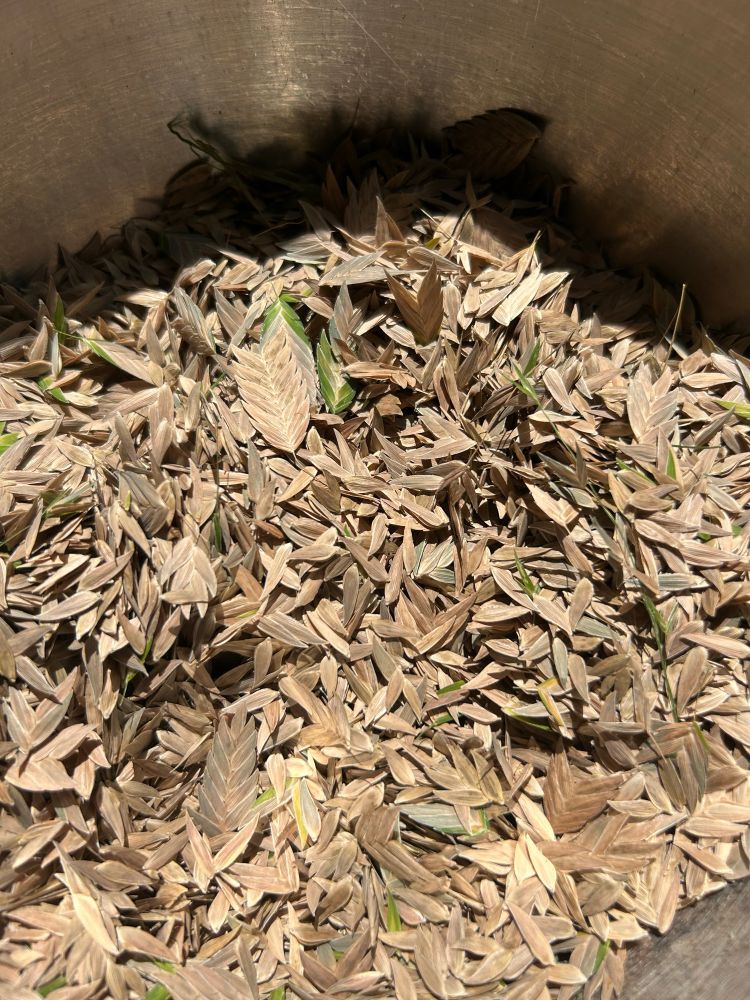
Planted too many sea oats, so I’m harvesting them for some neighborhood guerilla gardening. #nativeplants
October 13, 2025 at 4:55 PM
Planted too many sea oats, so I’m harvesting them for some neighborhood guerilla gardening. #nativeplants
It’s going to be a weird and not good end to the hurricane season, isn’t it? #LorenzoTheLooper

October 13, 2025 at 11:05 AM
It’s going to be a weird and not good end to the hurricane season, isn’t it? #LorenzoTheLooper
The pattern that supported Mitch in 1998 and Wilma in 2005 is eerily similar to today’s week two guidance.

October 9, 2025 at 10:04 PM
The pattern that supported Mitch in 1998 and Wilma in 2005 is eerily similar to today’s week two guidance.
CPC keeps the CAG TC risk going into late October.

October 7, 2025 at 7:43 PM
CPC keeps the CAG TC risk going into late October.
The Tule Fire in Briscoe County, TX, is burning in an area with at least 130% of normal fuel loading. Not a good sign for the Southern Plains the next 6 months given that fires over 1000 acres are rare this time of year.


October 4, 2025 at 8:49 PM
The Tule Fire in Briscoe County, TX, is burning in an area with at least 130% of normal fuel loading. Not a good sign for the Southern Plains the next 6 months given that fires over 1000 acres are rare this time of year.
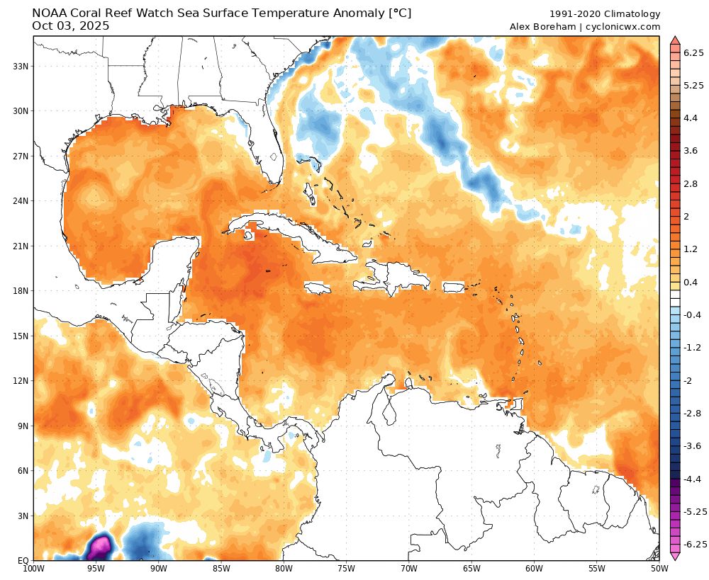
That near-record warm water could easily support intense hurricanes mid- to late month if other conditions align, but it remains to be seen if we’ll get any going outside of the subtropical Atlantic this year. GEFS mean shows the expected CAG well Oct. 12-15.
October 4, 2025 at 8:05 PM
That near-record warm water could easily support intense hurricanes mid- to late month if other conditions align, but it remains to be seen if we’ll get any going outside of the subtropical Atlantic this year. GEFS mean shows the expected CAG well Oct. 12-15.
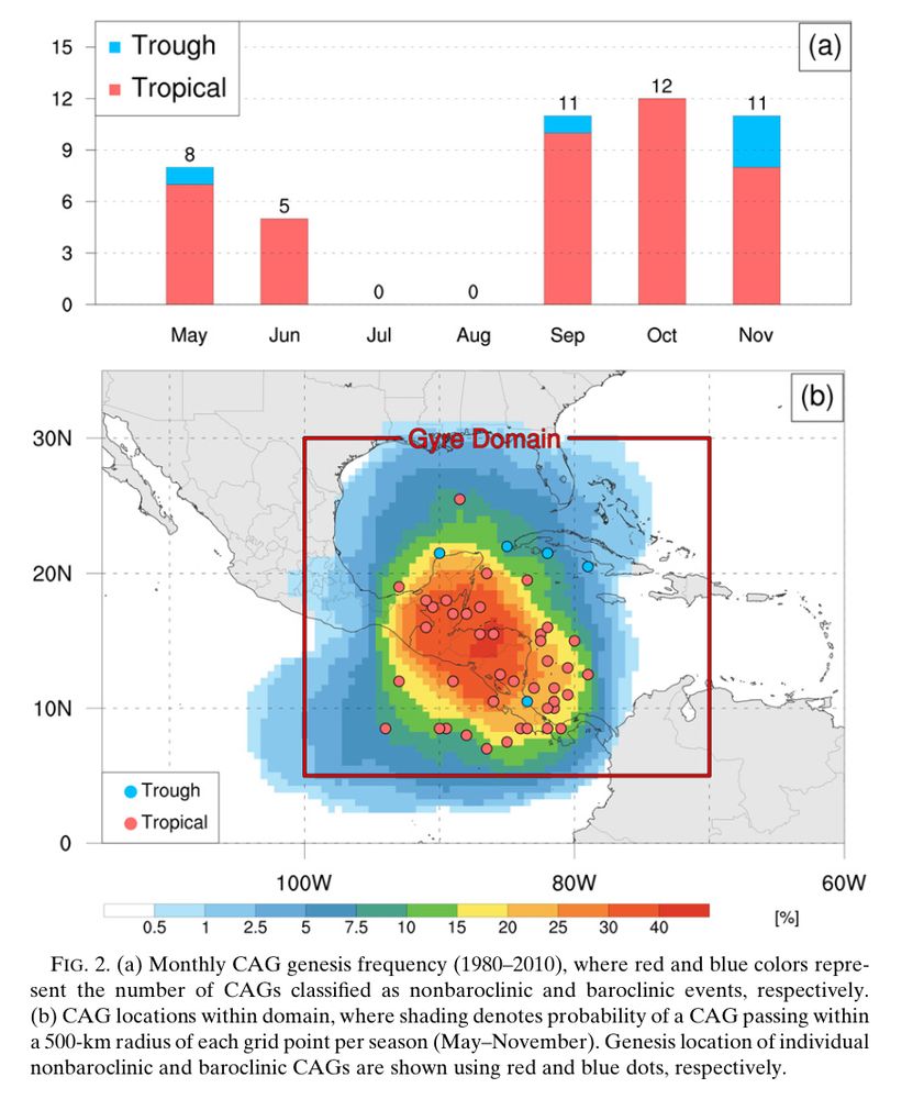
October is peak Central American Gyre (CAG) season, per the climatology from @pppapin.bsky.social et al (2017). Medium range ensembles are locking into the favorable RMM phases (8,1,2), and the untouched western Atlantic continues its 3-year stretch of absurd warmth.


October 4, 2025 at 8:05 PM
October is peak Central American Gyre (CAG) season, per the climatology from @pppapin.bsky.social et al (2017). Medium range ensembles are locking into the favorable RMM phases (8,1,2), and the untouched western Atlantic continues its 3-year stretch of absurd warmth.
lmao why is this bland abomination the first search result for fried okra?

October 3, 2025 at 8:04 PM
lmao why is this bland abomination the first search result for fried okra?
Our new wildland fire seasonal outlook is out. Should be a busy fall in the Southeast and dormant season in the Southern Plains. www.nifc.gov/nicc-files/p...


October 1, 2025 at 6:12 PM
Our new wildland fire seasonal outlook is out. Should be a busy fall in the Southeast and dormant season in the Southern Plains. www.nifc.gov/nicc-files/p...
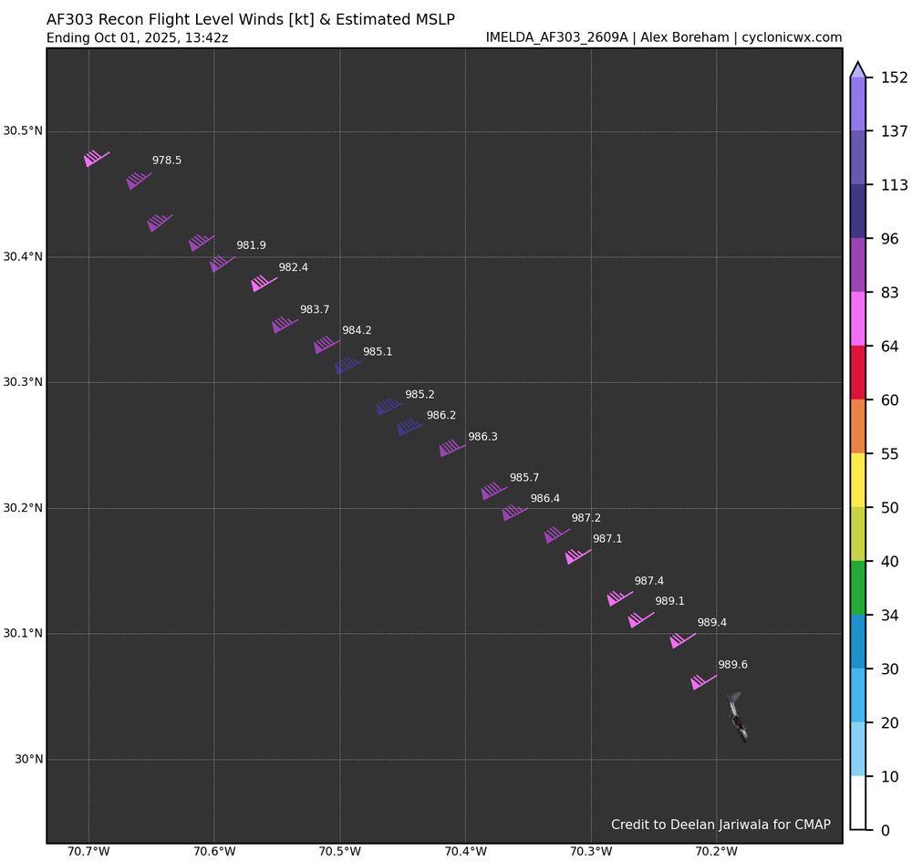
Imelda sure is close to being yet another major hurricane this morning.
October 1, 2025 at 1:50 PM
Imelda sure is close to being yet another major hurricane this morning.
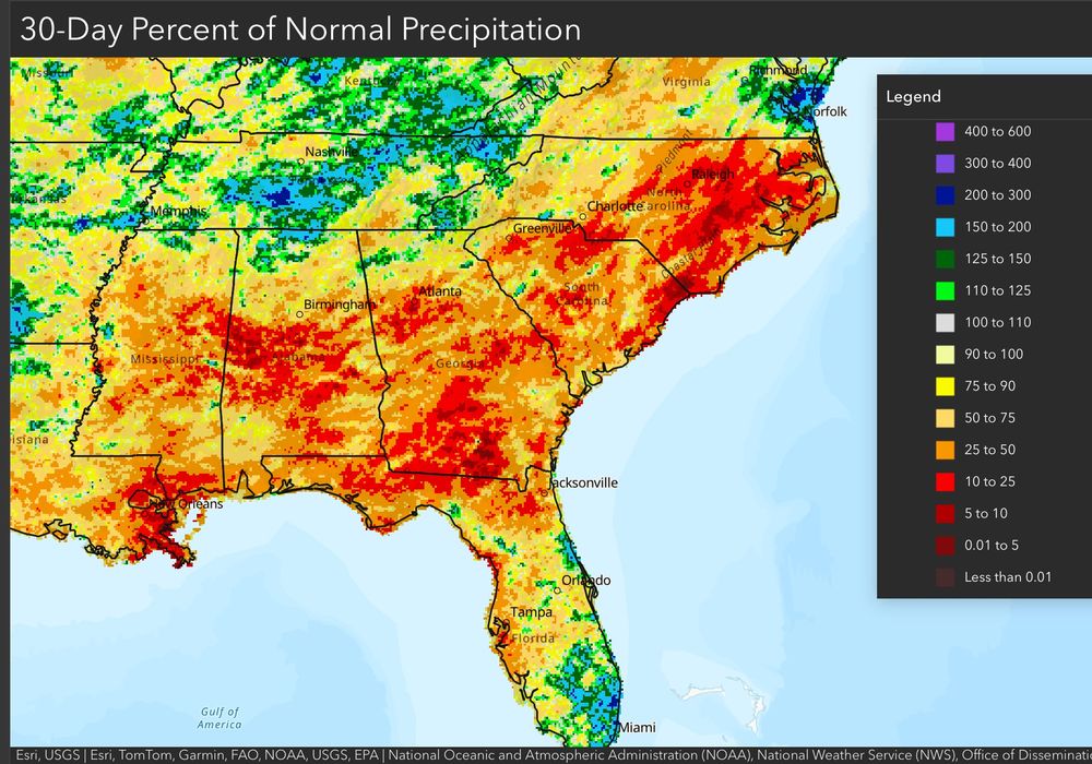
Some important updates from CPC today that could have major implications for the fall fire season in the southern and eastern US. A lack of landfilling storms has resulted in widespread drought, and any TCs that do form in what looks like a busy October could enhance fire activity to their north.


September 30, 2025 at 7:35 PM
Some important updates from CPC today that could have major implications for the fall fire season in the southern and eastern US. A lack of landfilling storms has resulted in widespread drought, and any TCs that do form in what looks like a busy October could enhance fire activity to their north.
See for yourself. Ain’t no way in hell drought caused the die off in Roseland. That dark red dot is off the scale.

September 30, 2025 at 3:16 PM
See for yourself. Ain’t no way in hell drought caused the die off in Roseland. That dark red dot is off the scale.
TD9 will bring some welcome short-term drought relief to the Carolinas ahead of likely deteriorating conditions in this winter’s La Niña. It’s exactly the type of tropical system land/fire managers hope for this time of year.
September 28, 2025 at 4:36 PM
TD9 will bring some welcome short-term drought relief to the Carolinas ahead of likely deteriorating conditions in this winter’s La Niña. It’s exactly the type of tropical system land/fire managers hope for this time of year.