


Michael Barnes
@weathermanbarnes.bsky.social
Meteorologist and Research Fellow at @21stcenturyweather.bsky.social,
@monashuniversity.bsky.social | www.weathermanbarnes.com
@monashuniversity.bsky.social | www.weathermanbarnes.com
Great example of a mid-troposphere frontal wave instability
July 31, 2025 at 9:40 AM
Great example of a mid-troposphere frontal wave instability
Ensemble mean column added :)

March 10, 2025 at 4:29 AM
Ensemble mean column added :)
Good idea, @windjunky.bsky.social. I will add that
March 10, 2025 at 3:35 AM
Good idea, @windjunky.bsky.social. I will add that
Do the BoM produce storm surge forecasts for that part of the world? Those numbers would be interesting and incredibly important for those people who live there....
February 14, 2025 at 3:38 AM
Do the BoM produce storm surge forecasts for that part of the world? Those numbers would be interesting and incredibly important for those people who live there....
Deep westeries and rainy. A hard, technical criteria is maybe not always the best....


January 23, 2025 at 4:02 AM
Deep westeries and rainy. A hard, technical criteria is maybe not always the best....
Work within the @21stcenturyweather.bsky.social will look at many of these topics including tropical-extratropical transitions, Tropical Cyclone impacts on heatwaves, diabatic influences on weather and weather systems and much more!
January 23, 2025 at 12:19 AM
Work within the @21stcenturyweather.bsky.social will look at many of these topics including tropical-extratropical transitions, Tropical Cyclone impacts on heatwaves, diabatic influences on weather and weather systems and much more!
The remnants of TC Sean that have transitioned into the extratropics, presumably bring with it additional moisture and diabatic heating into the mid-latitude waveguide. This process promotes anticyclogenesis in upper troposphere which in turn promotes adiabatic descent and heat into VIC next week
January 22, 2025 at 11:09 PM
The remnants of TC Sean that have transitioned into the extratropics, presumably bring with it additional moisture and diabatic heating into the mid-latitude waveguide. This process promotes anticyclogenesis in upper troposphere which in turn promotes adiabatic descent and heat into VIC next week
TC Sean will also play a hand in hot weather over the SE early next week, with temperatures expected to reach into the 40s in Victoria on Monday. Below is the ECMWF eIFS forecast for various parts of the state.

January 22, 2025 at 10:59 PM
TC Sean will also play a hand in hot weather over the SE early next week, with temperatures expected to reach into the 40s in Victoria on Monday. Below is the ECMWF eIFS forecast for various parts of the state.
Secondly and I think possibly most importantly, the outflow from TC Sean promotes ridging in the upper troposphere, pushing back the jet stream to the south of WA, similar to the effect studied by @tessjparker.bsky.social in her work on SE Aus heatwaves (doi.org/10.1002/2013...)
January 22, 2025 at 10:57 PM
Secondly and I think possibly most importantly, the outflow from TC Sean promotes ridging in the upper troposphere, pushing back the jet stream to the south of WA, similar to the effect studied by @tessjparker.bsky.social in her work on SE Aus heatwaves (doi.org/10.1002/2013...)
First, TC Sean tightens up the pressure gradient, promoting and strengthening easterlies and adiabatic descent towards the coast. Some of the below trajectories into Perth highlight this effect.
January 22, 2025 at 10:51 PM
First, TC Sean tightens up the pressure gradient, promoting and strengthening easterlies and adiabatic descent towards the coast. Some of the below trajectories into Perth highlight this effect.
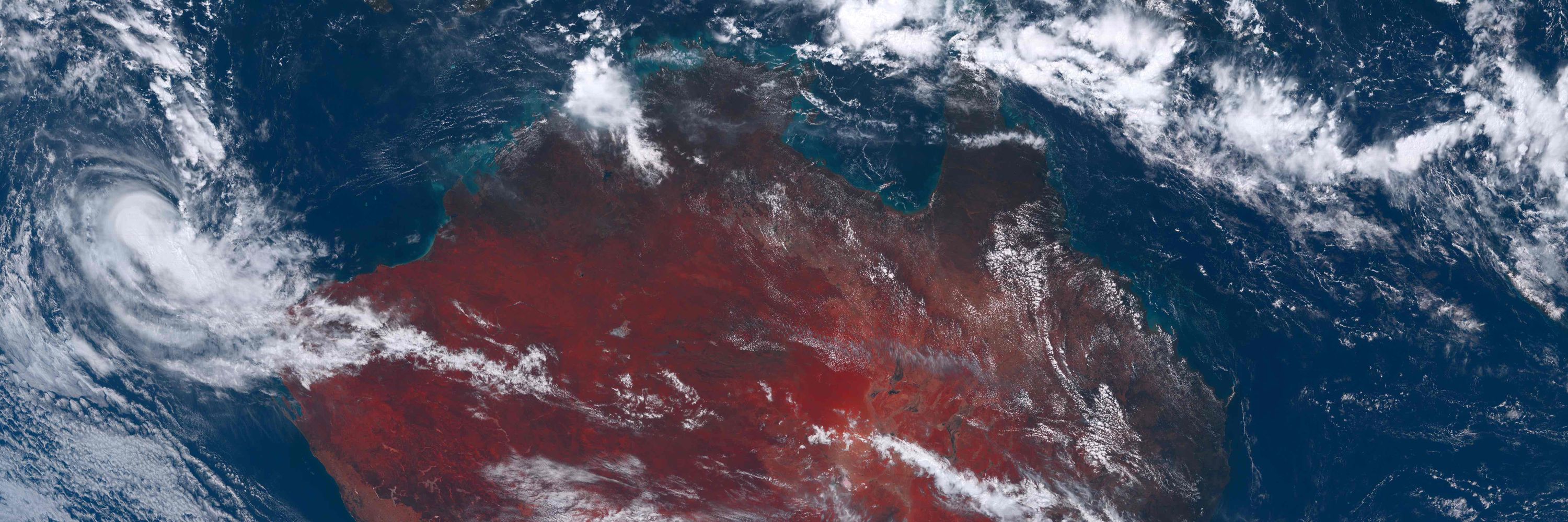
Southern WA experienced have experienced extremely hot temperatures, with Geraldton nearing the 50C mark. TC Sean has a part to play in this.

January 22, 2025 at 10:49 PM
Southern WA experienced have experienced extremely hot temperatures, with Geraldton nearing the 50C mark. TC Sean has a part to play in this.
Would love to know how on earth they get risk at the house level. Disingenuous and dishonest in my view.
December 30, 2024 at 10:03 AM
Would love to know how on earth they get risk at the house level. Disingenuous and dishonest in my view.
Ah cool. I like the comparing to neighbours! Will definitely check Tempest out. Thanks @ailiegallant.bsky.social!
December 17, 2024 at 10:13 PM
Ah cool. I like the comparing to neighbours! Will definitely check Tempest out. Thanks @ailiegallant.bsky.social!
This also explains the "bouncing" of most deterministic models between the mid-30s and low-40s for the over the last few days....
December 16, 2024 at 4:14 AM
This also explains the "bouncing" of most deterministic models between the mid-30s and low-40s for the over the last few days....