


Tom Hengl
@tomhengl.bsky.social
Director at OpenGeoHub / and technical director at EnvirometriX. I am a data scientist passionately promoting open data & FOSS4G, automated soil mapping, Machine Learning for environmental data, global data sets, R spatial and spatio-temporal modeling...
There are two global Lights at night images data sets (as far as I am aware of): the #VIIRS-based (500 m) covering 2011-2024 (doi.org/10.3390/rs13...) and DMSP (1 km) but covering 1992-2024 (doi.org/10.1038/s415...). I've used both data sets to derive Principal Components: doi.org/10.5281/zeno...

October 8, 2025 at 1:12 PM
There are two global Lights at night images data sets (as far as I am aware of): the #VIIRS-based (500 m) covering 2011-2024 (doi.org/10.3390/rs13...) and DMSP (1 km) but covering 1992-2024 (doi.org/10.1038/s415...). I've used both data sets to derive Principal Components: doi.org/10.5281/zeno...
Registrations are closing for the Perugia Global Workshop 17-19th September, 2025 #OpenEarthMonitor project earthmonitor.org/global-works...
Reserve your spot, register now 📣 : pretix.eu/opengeohubfo...
See you in Perugia!
Reserve your spot, register now 📣 : pretix.eu/opengeohubfo...
See you in Perugia!

August 13, 2025 at 2:15 PM
Registrations are closing for the Perugia Global Workshop 17-19th September, 2025 #OpenEarthMonitor project earthmonitor.org/global-works...
Reserve your spot, register now 📣 : pretix.eu/opengeohubfo...
See you in Perugia!
Reserve your spot, register now 📣 : pretix.eu/opengeohubfo...
See you in Perugia!
Senior Developer / Software Engineer wanted: #OpenSource tools for #geospatial data at @opengeohub.bsky.social
Application Deadline: 1st of Aug 2025
Possible start date: 1st of Oct 2025
Duration: 3+ years,
Job location: Doorwerth, NL
Bruto monthly salary: starting at €4,494 gross
Application Deadline: 1st of Aug 2025
Possible start date: 1st of Oct 2025
Duration: 3+ years,
Job location: Doorwerth, NL
Bruto monthly salary: starting at €4,494 gross

July 15, 2025 at 2:29 PM
Senior Developer / Software Engineer wanted: #OpenSource tools for #geospatial data at @opengeohub.bsky.social
Application Deadline: 1st of Aug 2025
Possible start date: 1st of Oct 2025
Duration: 3+ years,
Job location: Doorwerth, NL
Bruto monthly salary: starting at €4,494 gross
Application Deadline: 1st of Aug 2025
Possible start date: 1st of Oct 2025
Duration: 3+ years,
Job location: Doorwerth, NL
Bruto monthly salary: starting at €4,494 gross
📢 Researchers wanted!
- PhD candidate: Hybrid geospatial modeling of carbon fluxes and associated uncertainty for scenario testing (opengeohub.org/jobs/researc... with Uni of Utrecht),
- Research assistant: modeling land use & land cover dynamics using ML & AI (opengeohub.org/jobs/researc...),
- PhD candidate: Hybrid geospatial modeling of carbon fluxes and associated uncertainty for scenario testing (opengeohub.org/jobs/researc... with Uni of Utrecht),
- Research assistant: modeling land use & land cover dynamics using ML & AI (opengeohub.org/jobs/researc...),

June 24, 2025 at 9:10 AM
📢 Researchers wanted!
- PhD candidate: Hybrid geospatial modeling of carbon fluxes and associated uncertainty for scenario testing (opengeohub.org/jobs/researc... with Uni of Utrecht),
- Research assistant: modeling land use & land cover dynamics using ML & AI (opengeohub.org/jobs/researc...),
- PhD candidate: Hybrid geospatial modeling of carbon fluxes and associated uncertainty for scenario testing (opengeohub.org/jobs/researc... with Uni of Utrecht),
- Research assistant: modeling land use & land cover dynamics using ML & AI (opengeohub.org/jobs/researc...),

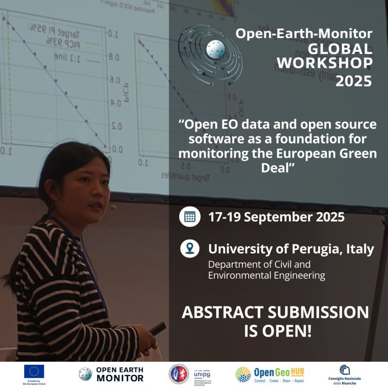
📢 Call for Abstracts for @openearthmonitor.bsky.social 𝗚𝗹𝗼𝗯𝗮𝗹 𝗪𝗼𝗿𝗸𝘀𝗵𝗼𝗽 𝟮𝟬𝟮𝟱 𝗶𝘀 𝗡𝗢𝗪 𝗢𝗣𝗘𝗡!
🌍 “Open EO data and open source software as a foundation for monitoring the European Green Deal”,
🗓️ Date: 17-19 September 2025
📍 Location: University of Perugia, Italy
👉 opengeohub.org/summer-schoo...
🌍 “Open EO data and open source software as a foundation for monitoring the European Green Deal”,
🗓️ Date: 17-19 September 2025
📍 Location: University of Perugia, Italy
👉 opengeohub.org/summer-schoo...
June 10, 2025 at 12:04 PM
📢 Call for Abstracts for @openearthmonitor.bsky.social 𝗚𝗹𝗼𝗯𝗮𝗹 𝗪𝗼𝗿𝗸𝘀𝗵𝗼𝗽 𝟮𝟬𝟮𝟱 𝗶𝘀 𝗡𝗢𝗪 𝗢𝗣𝗘𝗡!
🌍 “Open EO data and open source software as a foundation for monitoring the European Green Deal”,
🗓️ Date: 17-19 September 2025
📍 Location: University of Perugia, Italy
👉 opengeohub.org/summer-schoo...
🌍 “Open EO data and open source software as a foundation for monitoring the European Green Deal”,
🗓️ Date: 17-19 September 2025
📍 Location: University of Perugia, Italy
👉 opengeohub.org/summer-schoo...
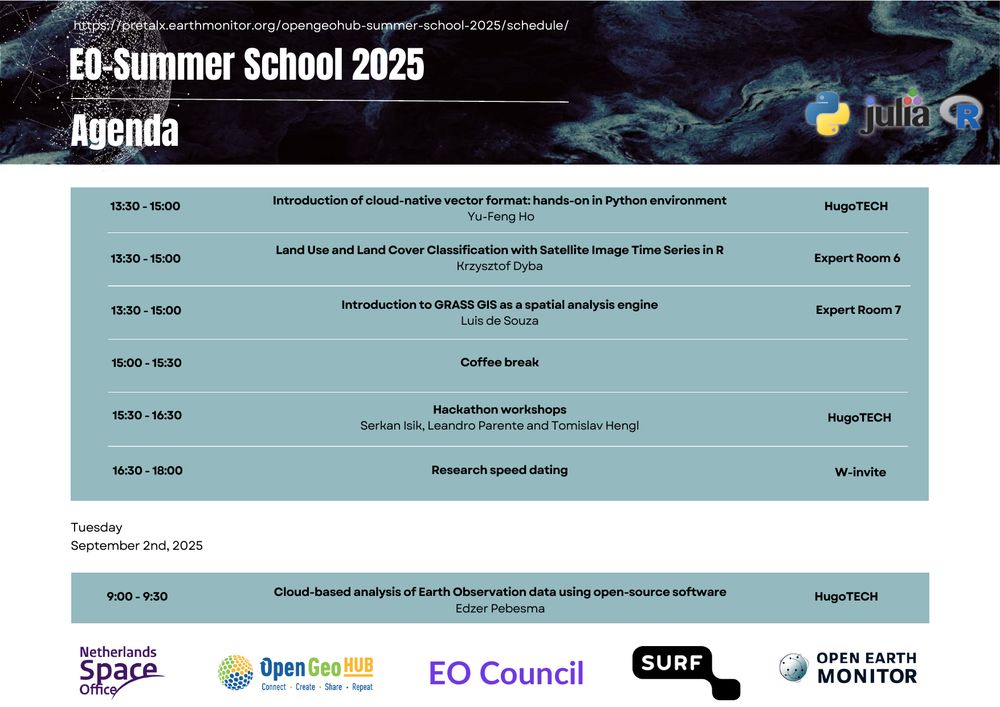
Draft programme for the OpenGeoHub summer school "Data Science for Earth Observation: Hands-on Training in Python, R and Julia" 1—6 September 2025, WICC, Wageningen, is now public: opengeohub.org/summer-schoo...
1 week, 20 lecturers; deadline: 1st of July! #python #R #earthobservation #Geospatial
1 week, 20 lecturers; deadline: 1st of July! #python #R #earthobservation #Geospatial


May 28, 2025 at 6:03 PM
Draft programme for the OpenGeoHub summer school "Data Science for Earth Observation: Hands-on Training in Python, R and Julia" 1—6 September 2025, WICC, Wageningen, is now public: opengeohub.org/summer-schoo...
1 week, 20 lecturers; deadline: 1st of July! #python #R #earthobservation #Geospatial
1 week, 20 lecturers; deadline: 1st of July! #python #R #earthobservation #Geospatial
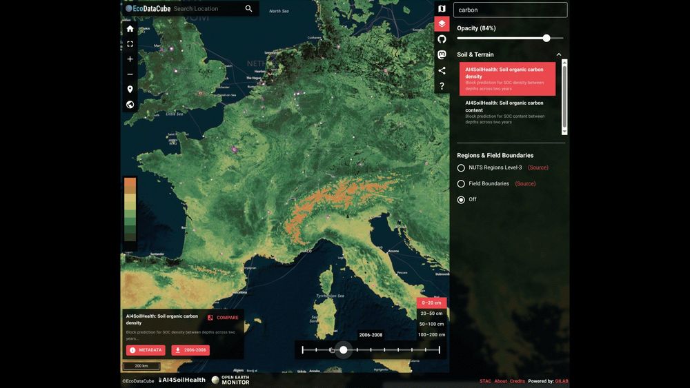
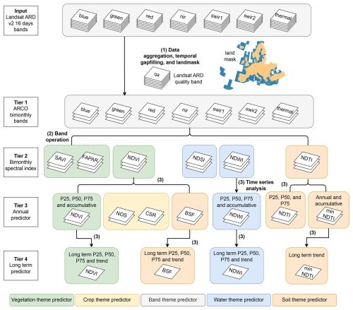
The V2 ecodatacube.eu now includes also dynamic soil properties "Soil Health Data Cube" @ai4soilhealth.bsky.social and @openearthmonitor.bsky.social , bimonthly time-series of biophysical indices (doi.org/10.5194/essd...), including #soilcarbon density predictions (doi.org/10.21203/rs....).
May 4, 2025 at 10:14 PM
The V2 ecodatacube.eu now includes also dynamic soil properties "Soil Health Data Cube" @ai4soilhealth.bsky.social and @openearthmonitor.bsky.social , bimonthly time-series of biophysical indices (doi.org/10.5194/essd...), including #soilcarbon density predictions (doi.org/10.21203/rs....).
2 webinars in May: "Global 30-m resolution ensemble DTM and canopy height data (2000-2022)"
www.eventbrite.com/e/1334229118...
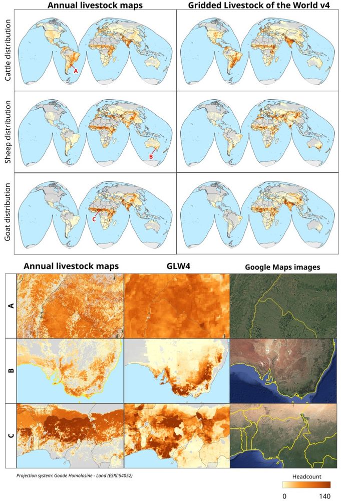
"ML methods for census data: lessons learned from mapping global livestocks"
www.eventbrite.com/e/1334292999...
to celebrate @earthdayorg.bsky.social
Reserve your place!
www.eventbrite.com/e/1334229118...
"ML methods for census data: lessons learned from mapping global livestocks"
www.eventbrite.com/e/1334292999...
to celebrate @earthdayorg.bsky.social
Reserve your place!


April 22, 2025 at 7:06 PM
2 webinars in May: "Global 30-m resolution ensemble DTM and canopy height data (2000-2022)"
www.eventbrite.com/e/1334229118...
"ML methods for census data: lessons learned from mapping global livestocks"
www.eventbrite.com/e/1334292999...
to celebrate @earthdayorg.bsky.social
Reserve your place!
www.eventbrite.com/e/1334229118...
"ML methods for census data: lessons learned from mapping global livestocks"
www.eventbrite.com/e/1334292999...
to celebrate @earthdayorg.bsky.social
Reserve your place!
Use Early Access application and request data via: survey.alchemer.com/s3/7859804/P... (you will be asked to fill-in a short form). Reference sample data used for model training is also available: doi.org/10.5281/zeno...
If you notice an issue or artifact please report!
If you notice an issue or artifact please report!
March 28, 2025 at 1:12 PM
Use Early Access application and request data via: survey.alchemer.com/s3/7859804/P... (you will be asked to fill-in a short form). Reference sample data used for model training is also available: doi.org/10.5281/zeno...
If you notice an issue or artifact please report!
If you notice an issue or artifact please report!
SOC density is derived by measuring SOC content and Bulk density (separately) and then by a simple formula:
SOC [kg/m3] = SOC [dg/kg]/100 * BD [kg/m3] * (1-CF)
where CF is the coarse fragments fraction (0-1). SOC density for a standard agricultural soil is about 12 kg/m3 at 10 cm depth. [3/5]
SOC [kg/m3] = SOC [dg/kg]/100 * BD [kg/m3] * (1-CF)
where CF is the coarse fragments fraction (0-1). SOC density for a standard agricultural soil is about 12 kg/m3 at 10 cm depth. [3/5]

March 21, 2025 at 11:43 AM
SOC density is derived by measuring SOC content and Bulk density (separately) and then by a simple formula:
SOC [kg/m3] = SOC [dg/kg]/100 * BD [kg/m3] * (1-CF)
where CF is the coarse fragments fraction (0-1). SOC density for a standard agricultural soil is about 12 kg/m3 at 10 cm depth. [3/5]
SOC [kg/m3] = SOC [dg/kg]/100 * BD [kg/m3] * (1-CF)
where CF is the coarse fragments fraction (0-1). SOC density for a standard agricultural soil is about 12 kg/m3 at 10 cm depth. [3/5]
In summary, there are four main variables used to represent SOC:
1. SOC fraction or content (ORC) in g/kg (permille) or dg/kg (%),
2. SOC Density (OCD) in kg/m3
3. SOC Stock (OCS) in kg/m2 or in t/ha and for the given soil depth interval,
4. Total SOC Stock (TOCS) in million t or Pg,
[2/5]
1. SOC fraction or content (ORC) in g/kg (permille) or dg/kg (%),
2. SOC Density (OCD) in kg/m3
3. SOC Stock (OCS) in kg/m2 or in t/ha and for the given soil depth interval,
4. Total SOC Stock (TOCS) in million t or Pg,
[2/5]

March 21, 2025 at 11:43 AM
In summary, there are four main variables used to represent SOC:
1. SOC fraction or content (ORC) in g/kg (permille) or dg/kg (%),
2. SOC Density (OCD) in kg/m3
3. SOC Stock (OCS) in kg/m2 or in t/ha and for the given soil depth interval,
4. Total SOC Stock (TOCS) in million t or Pg,
[2/5]
1. SOC fraction or content (ORC) in g/kg (permille) or dg/kg (%),
2. SOC Density (OCD) in kg/m3
3. SOC Stock (OCS) in kg/m2 or in t/ha and for the given soil depth interval,
4. Total SOC Stock (TOCS) in million t or Pg,
[2/5]
#SoilOrganicCarbon (organic matter / plant and animal residues at various stages of decomposition) is one of the key indicators of #soilhealth / soil ecosystem services. But how do you measure and report SOC? We advocate that SOC density [kg/m3] is the central variable to monitor SOC dynamics [1/5]

March 21, 2025 at 11:43 AM
#SoilOrganicCarbon (organic matter / plant and animal residues at various stages of decomposition) is one of the key indicators of #soilhealth / soil ecosystem services. But how do you measure and report SOC? We advocate that SOC density [kg/m3] is the central variable to monitor SOC dynamics [1/5]
The papers and data we mentioned in the podcast (producing open data for the EU) are at: essd.copernicus.org/articles/17/... and doi.org/10.21203/rs....
March 6, 2025 at 2:47 PM
The papers and data we mentioned in the podcast (producing open data for the EU) are at: essd.copernicus.org/articles/17/... and doi.org/10.21203/rs....
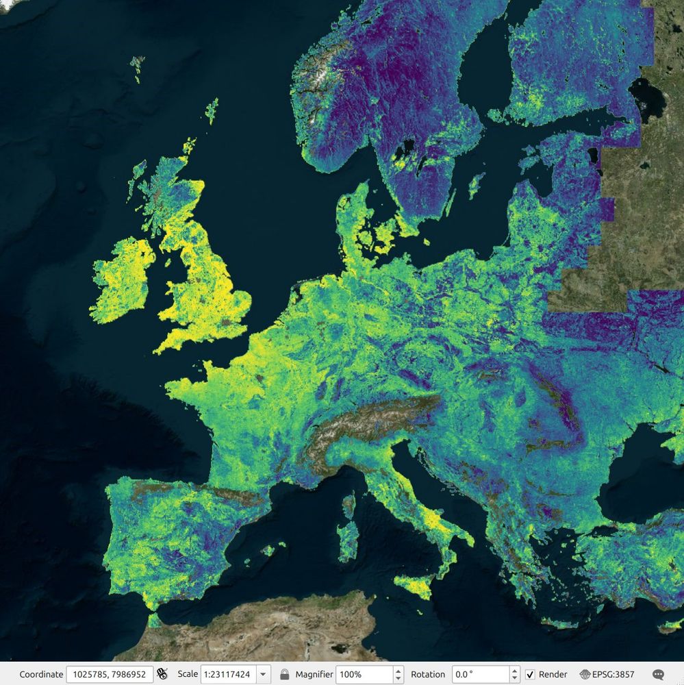
I made long-term estimates of soil moisture at 1km for EU (quarterly 2014-2024) based on Copernicus Land Monitoring Service. I tried also producing monthly/bimonthly aggregates, but these have too many artifacts. You can assess data under CC-BY at: doi.org/10.5281/zeno...
@ai4soilhealth.bsky.social
@ai4soilhealth.bsky.social
February 7, 2025 at 2:12 PM
I made long-term estimates of soil moisture at 1km for EU (quarterly 2014-2024) based on Copernicus Land Monitoring Service. I tried also producing monthly/bimonthly aggregates, but these have too many artifacts. You can assess data under CC-BY at: doi.org/10.5281/zeno...
@ai4soilhealth.bsky.social
@ai4soilhealth.bsky.social
Applications for the OpenGeoHub EO-Council.nl summer school 2025 "Data Science for Earth Observation: Hands-on Training in Python, R and Julia" are closing on 18th of January 2025. Eager to meet other young scholars in the field? Apply here: opengeohub.org/summer-schoo...
av.tib.eu/publisher/Op...
av.tib.eu/publisher/Op...


January 9, 2025 at 4:15 PM
Applications for the OpenGeoHub EO-Council.nl summer school 2025 "Data Science for Earth Observation: Hands-on Training in Python, R and Julia" are closing on 18th of January 2025. Eager to meet other young scholars in the field? Apply here: opengeohub.org/summer-schoo...
av.tib.eu/publisher/Op...
av.tib.eu/publisher/Op...
We are hiring 1-2 #pedometrics #envirometrics #geospatial experts / assistant researchers to join our global and pan-EU projects #LandCarbonLab @ai4soilhealth.bsky.social : "Post-doctoral researcher: dynamic soil-landscape modeling". Please apply before: 1-Jan-2025! opengeohub.org/jobs/post-do...

December 26, 2024 at 9:33 AM
We are hiring 1-2 #pedometrics #envirometrics #geospatial experts / assistant researchers to join our global and pan-EU projects #LandCarbonLab @ai4soilhealth.bsky.social : "Post-doctoral researcher: dynamic soil-landscape modeling". Please apply before: 1-Jan-2025! opengeohub.org/jobs/post-do...
It is estimated that humans have cut down about 1/3rd of the global forests since pre-industrial times. Another 1/3rd is degraded. We tragically ignore how much nature we have consumed, as it is infinite. This is an estimate of the tree cover loss for the period 1985 to 2022: doi.org/10.5281/zeno...


December 13, 2024 at 10:30 AM
It is estimated that humans have cut down about 1/3rd of the global forests since pre-industrial times. Another 1/3rd is degraded. We tragically ignore how much nature we have consumed, as it is infinite. This is an estimate of the tree cover loss for the period 1985 to 2022: doi.org/10.5281/zeno...
Applications for the @OpenGeoHub EO-Summer School: "Data Science for Earth Observation: Hands-on Training in Python, R and Julia" are now open! 1-6 Sept 2025 at the Wageningen International Congress Centre 🇳🇱
Organized in collaboration with EO Council and SURF.nl. opengeohub.org/summer-schoo...
Organized in collaboration with EO Council and SURF.nl. opengeohub.org/summer-schoo...

December 11, 2024 at 6:32 PM
Applications for the @OpenGeoHub EO-Summer School: "Data Science for Earth Observation: Hands-on Training in Python, R and Julia" are now open! 1-6 Sept 2025 at the Wageningen International Congress Centre 🇳🇱
Organized in collaboration with EO Council and SURF.nl. opengeohub.org/summer-schoo...
Organized in collaboration with EO Council and SURF.nl. opengeohub.org/summer-schoo...
Our 2cent contribution for the #WorldSoilDay we produced the first ever 30-m spatial resolution dynamic map 🗺️ (2000-2022) predicting the soil carbon density [kg/m3] trends across pan-EU (www.researchsquare.com/article/rs-5...);
The data & code 👩💻 available from zenodo.org/communities/...
The data & code 👩💻 available from zenodo.org/communities/...

December 5, 2024 at 9:50 AM
Our 2cent contribution for the #WorldSoilDay we produced the first ever 30-m spatial resolution dynamic map 🗺️ (2000-2022) predicting the soil carbon density [kg/m3] trends across pan-EU (www.researchsquare.com/article/rs-5...);
The data & code 👩💻 available from zenodo.org/communities/...
The data & code 👩💻 available from zenodo.org/communities/...