


Simon Brewer
@stormgasm.bsky.social
Meteorologist, Storm Chaser, Journalist & Photographer: Hurricanes, Tornadoes, & Winter Storms
www.stormgasm.com
www.stormgasm.com
#MegawedgeMonday
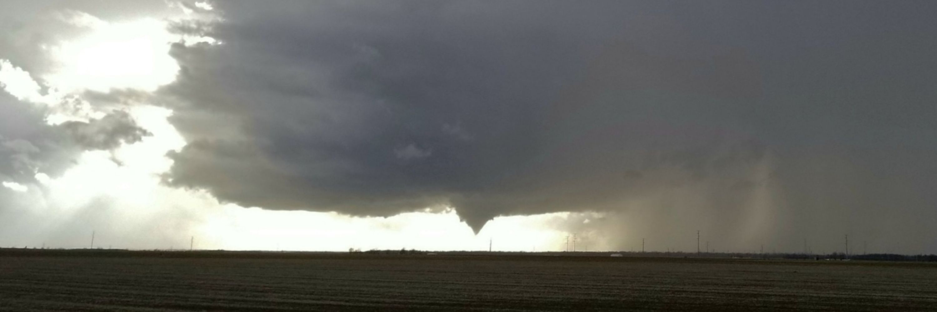
May 31, 2013 El Reno, Oklahoma
Megawedge (noun) - defined as a visually wedge-shaped tornado with respect to the observer from a wall cloud or updraft base to Earth's surface with a diameter equal to or greater than 1.5 miles in diameter.
#okwx
May 31, 2013 El Reno, Oklahoma
Megawedge (noun) - defined as a visually wedge-shaped tornado with respect to the observer from a wall cloud or updraft base to Earth's surface with a diameter equal to or greater than 1.5 miles in diameter.
#okwx

November 24, 2025 at 3:59 PM
#MegawedgeMonday
May 31, 2013 El Reno, Oklahoma
Megawedge (noun) - defined as a visually wedge-shaped tornado with respect to the observer from a wall cloud or updraft base to Earth's surface with a diameter equal to or greater than 1.5 miles in diameter.
#okwx
May 31, 2013 El Reno, Oklahoma
Megawedge (noun) - defined as a visually wedge-shaped tornado with respect to the observer from a wall cloud or updraft base to Earth's surface with a diameter equal to or greater than 1.5 miles in diameter.
#okwx
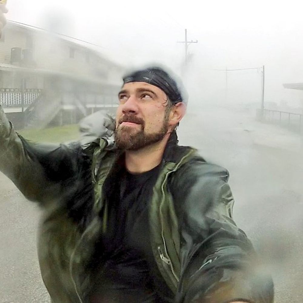
What a year 2025 has been so far!
Still 5+ weeks to go...
with @JustonStrmRider
Still 5+ weeks to go...
with @JustonStrmRider


November 21, 2025 at 8:16 PM
What a year 2025 has been so far!
Still 5+ weeks to go...
with @JustonStrmRider
Still 5+ weeks to go...
with @JustonStrmRider
Radar vs. View:
Intense convective snowband training off Lake Erie over Buffalo, NY creates what looks to be a WALL OF SNOW!
OTD 3 years ago, @ 3:36 AM EST 17 November 2022 from NW side of Buffalo looking south.
@NWSBUFFALO #NYwx
Intense convective snowband training off Lake Erie over Buffalo, NY creates what looks to be a WALL OF SNOW!
OTD 3 years ago, @ 3:36 AM EST 17 November 2022 from NW side of Buffalo looking south.
@NWSBUFFALO #NYwx


November 18, 2025 at 1:01 AM
Radar vs. View:
Intense convective snowband training off Lake Erie over Buffalo, NY creates what looks to be a WALL OF SNOW!
OTD 3 years ago, @ 3:36 AM EST 17 November 2022 from NW side of Buffalo looking south.
@NWSBUFFALO #NYwx
Intense convective snowband training off Lake Erie over Buffalo, NY creates what looks to be a WALL OF SNOW!
OTD 3 years ago, @ 3:36 AM EST 17 November 2022 from NW side of Buffalo looking south.
@NWSBUFFALO #NYwx
OTD 11 years ago on November 17-19 2014, and again 3 years ago on November 17-19 2022, I documented epic lake effect snow events over the Buffalo and Southtowns area.
#NYwx #LakeEffect #snow #thundersnow
#NYwx #LakeEffect #snow #thundersnow


November 17, 2025 at 7:20 PM
OTD 11 years ago on November 17-19 2014, and again 3 years ago on November 17-19 2022, I documented epic lake effect snow events over the Buffalo and Southtowns area.
#NYwx #LakeEffect #snow #thundersnow
#NYwx #LakeEffect #snow #thundersnow
Colors of November 2025


November 14, 2025 at 12:18 PM
Colors of November 2025


NEW VIDEO from a HUMAN!!!
Indiana Lake Effect Snow:
First decent lake effect snow event of the season over Northwest Indiana
#inwx
youtu.be/gUX5HbQpIvE?...
Indiana Lake Effect Snow:
First decent lake effect snow event of the season over Northwest Indiana
#inwx
youtu.be/gUX5HbQpIvE?...

November 10, 2025 at 8:52 PM
NEW VIDEO from a HUMAN!!!
Indiana Lake Effect Snow:
First decent lake effect snow event of the season over Northwest Indiana
#inwx
youtu.be/gUX5HbQpIvE?...
Indiana Lake Effect Snow:
First decent lake effect snow event of the season over Northwest Indiana
#inwx
youtu.be/gUX5HbQpIvE?...

November might be the most interesting month for extreme weather in the USA. Potential for tornadoes, hurricanes, Nor'easters, and intense lake effect snow.
#November
#November


November 2, 2025 at 6:19 PM
November might be the most interesting month for extreme weather in the USA. Potential for tornadoes, hurricanes, Nor'easters, and intense lake effect snow.
#November
#November
Happy Halloween 2025!!!

November 1, 2025 at 12:15 AM
Happy Halloween 2025!!!
Something like this hasn't happened since 1935: a high-end, sub-900mb CAT 5 Tropical Cyclone made landfall at/near peak intensity in the Atlantic Basin. The October 28, 2025 Hurricane Melissa Jamaica landfall event is a rare meteorological moment in history.

October 29, 2025 at 5:24 PM
Something like this hasn't happened since 1935: a high-end, sub-900mb CAT 5 Tropical Cyclone made landfall at/near peak intensity in the Atlantic Basin. The October 28, 2025 Hurricane Melissa Jamaica landfall event is a rare meteorological moment in history.
Appears CAT 5 Hurricane Melissa made landfall near New Hope, Jamaica with an incredibly low estimated minimum central pressure of 892 mb and devastating maximum sustained winds of 185 mph with higher gusts possibly exceeding 200 mph. Also, tornado or tornado-like whirls possible!

October 28, 2025 at 5:01 PM
Appears CAT 5 Hurricane Melissa made landfall near New Hope, Jamaica with an incredibly low estimated minimum central pressure of 892 mb and devastating maximum sustained winds of 185 mph with higher gusts possibly exceeding 200 mph. Also, tornado or tornado-like whirls possible!
Have to wonder if the Jamaican high terrain and/or trochoidal wobbles will have a significant impact on the potential landfall location of CAT 5 Hurricane Melissa. Localized enhanced steering currents can develop between the core of tropical cyclones and high terrain islands...

October 27, 2025 at 4:56 PM
Have to wonder if the Jamaican high terrain and/or trochoidal wobbles will have a significant impact on the potential landfall location of CAT 5 Hurricane Melissa. Localized enhanced steering currents can develop between the core of tropical cyclones and high terrain islands...
Incredible outflow channel ventilation for CAT 5 Hurricane Melissa over the Caribbean.
The most intense tropical cyclones typically have massive outflow channels like these.
October 27, 2025 #Jamaica
The most intense tropical cyclones typically have massive outflow channels like these.
October 27, 2025 #Jamaica

October 27, 2025 at 1:59 PM
Incredible outflow channel ventilation for CAT 5 Hurricane Melissa over the Caribbean.
The most intense tropical cyclones typically have massive outflow channels like these.
October 27, 2025 #Jamaica
The most intense tropical cyclones typically have massive outflow channels like these.
October 27, 2025 #Jamaica
CAT 5 Hurricane Melissa looks incredibly intense on satellite just south of Jamaica. The storm is likely to turn north today and tomorrow and cause catastrophic damage over Jamaica as a powerhouse.

October 27, 2025 at 12:43 PM
CAT 5 Hurricane Melissa looks incredibly intense on satellite just south of Jamaica. The storm is likely to turn north today and tomorrow and cause catastrophic damage over Jamaica as a powerhouse.
#weatherpicofday
Documented 7 tornadoes over Southwest Kansas between the communities of Dodge City and Cold Water during a regional coldcore outbreak OTD 19 years ago, October 26, 2006. Most were landspout variety with triplets at one point. w/ Mark McGowan #KSwx
Documented 7 tornadoes over Southwest Kansas between the communities of Dodge City and Cold Water during a regional coldcore outbreak OTD 19 years ago, October 26, 2006. Most were landspout variety with triplets at one point. w/ Mark McGowan #KSwx


October 26, 2025 at 12:04 PM
#weatherpicofday
Documented 7 tornadoes over Southwest Kansas between the communities of Dodge City and Cold Water during a regional coldcore outbreak OTD 19 years ago, October 26, 2006. Most were landspout variety with triplets at one point. w/ Mark McGowan #KSwx
Documented 7 tornadoes over Southwest Kansas between the communities of Dodge City and Cold Water during a regional coldcore outbreak OTD 19 years ago, October 26, 2006. Most were landspout variety with triplets at one point. w/ Mark McGowan #KSwx
Hurricane Melissa looks like an absolute beast this morning. It appears to slowly be chugging toward Jamaica and then Cuba the next few days. These islands will probably get incredible amounts of rainfall likely resulting in devastating floods and mudslides. #HurricaneMelissa

October 26, 2025 at 10:25 AM
Hurricane Melissa looks like an absolute beast this morning. It appears to slowly be chugging toward Jamaica and then Cuba the next few days. These islands will probably get incredible amounts of rainfall likely resulting in devastating floods and mudslides. #HurricaneMelissa


October 23, 2025 at 11:24 AM
OTD 25 years ago, October 22, 2000, I saw my first tornado over the Southeast-side of Oklahoma City, OK with friend and fellow newbie storm chaser Jim Bishop.
Saw powerflashes from a tornado near Crossroads Mall. Later, we were hit by possibly the same circulation northeast of the mall. #OKwx
Saw powerflashes from a tornado near Crossroads Mall. Later, we were hit by possibly the same circulation northeast of the mall. #OKwx

October 23, 2025 at 3:22 AM
OTD 25 years ago, October 22, 2000, I saw my first tornado over the Southeast-side of Oklahoma City, OK with friend and fellow newbie storm chaser Jim Bishop.
Saw powerflashes from a tornado near Crossroads Mall. Later, we were hit by possibly the same circulation northeast of the mall. #OKwx
Saw powerflashes from a tornado near Crossroads Mall. Later, we were hit by possibly the same circulation northeast of the mall. #OKwx
OTD 3 year ago tonight, October, 22, 2022, I was in Nayarit, Mexico waiting for Category 4 #Hurricane #Roslyn. It made landfall during early morning hours the following day, the 23rd, as a strong CAT 3.
Please watch the chase video below:
youtu.be/UGIByoYXqoo?...
Please watch the chase video below:
youtu.be/UGIByoYXqoo?...

October 23, 2025 at 3:19 AM
OTD 3 year ago tonight, October, 22, 2022, I was in Nayarit, Mexico waiting for Category 4 #Hurricane #Roslyn. It made landfall during early morning hours the following day, the 23rd, as a strong CAT 3.
Please watch the chase video below:
youtu.be/UGIByoYXqoo?...
Please watch the chase video below:
youtu.be/UGIByoYXqoo?...
Found Comet Lemmon!
Crappie cell phone long exposure.
Will pull out thd bigger guns in a few days to better capture this ball of ice and dust.
#ohwx
Crappie cell phone long exposure.
Will pull out thd bigger guns in a few days to better capture this ball of ice and dust.
#ohwx

October 21, 2025 at 12:30 AM
Found Comet Lemmon!
Crappie cell phone long exposure.
Will pull out thd bigger guns in a few days to better capture this ball of ice and dust.
#ohwx
Crappie cell phone long exposure.
Will pull out thd bigger guns in a few days to better capture this ball of ice and dust.
#ohwx
OTD 7 years ago, October 10, 2018,
@JustonStrmRider and I rode-out the intense right 'eyewall' of devastating CAT 5 Hurricane Michael in Mexico Beach, Florida. We barely stayed above a rushing 15 foot storm surge.
VIDEO LINK BELOW:
youtu.be/XdTRboLzoUo?...
@JustonStrmRider and I rode-out the intense right 'eyewall' of devastating CAT 5 Hurricane Michael in Mexico Beach, Florida. We barely stayed above a rushing 15 foot storm surge.
VIDEO LINK BELOW:
youtu.be/XdTRboLzoUo?...


October 10, 2025 at 6:52 PM
OTD 7 years ago, October 10, 2018,
@JustonStrmRider and I rode-out the intense right 'eyewall' of devastating CAT 5 Hurricane Michael in Mexico Beach, Florida. We barely stayed above a rushing 15 foot storm surge.
VIDEO LINK BELOW:
youtu.be/XdTRboLzoUo?...
@JustonStrmRider and I rode-out the intense right 'eyewall' of devastating CAT 5 Hurricane Michael in Mexico Beach, Florida. We barely stayed above a rushing 15 foot storm surge.
VIDEO LINK BELOW:
youtu.be/XdTRboLzoUo?...
First frost of the season in Dayton, Ohio (October 10, 2025). Relatively close reporting ASOS stations are at 40°F, but that's at 10 meters or ~30 feet elevation. The metal roofs of cars radiate heat more efficiently at lower elevation, so the morning dew froze. #ohwx #frostwarning
October 10, 2025 at 11:57 AM
First frost of the season in Dayton, Ohio (October 10, 2025). Relatively close reporting ASOS stations are at 40°F, but that's at 10 meters or ~30 feet elevation. The metal roofs of cars radiate heat more efficiently at lower elevation, so the morning dew froze. #ohwx #frostwarning
#weatherpicofday
OTD 24 years ago Jim Bishop and I documented 2 twisters and several supercells during little outbreak in Western Oklahoma. Incredible how many years have passed!
#okwx
OTD 24 years ago Jim Bishop and I documented 2 twisters and several supercells during little outbreak in Western Oklahoma. Incredible how many years have passed!
#okwx


October 10, 2025 at 1:33 AM
#weatherpicofday
OTD 24 years ago Jim Bishop and I documented 2 twisters and several supercells during little outbreak in Western Oklahoma. Incredible how many years have passed!
#okwx
OTD 24 years ago Jim Bishop and I documented 2 twisters and several supercells during little outbreak in Western Oklahoma. Incredible how many years have passed!
#okwx