


Mark Snoeck
@snoeck.bsky.social
Open Source Investigator | Sudan | Views are my own
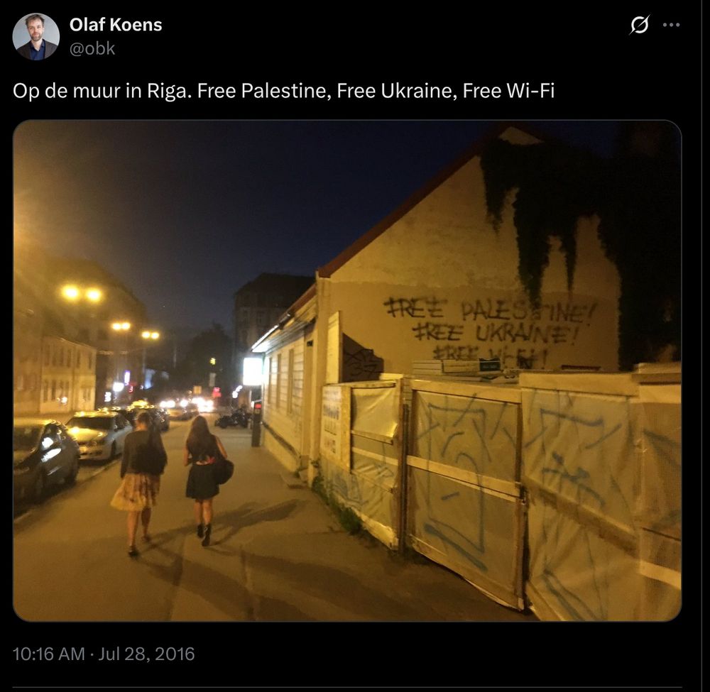
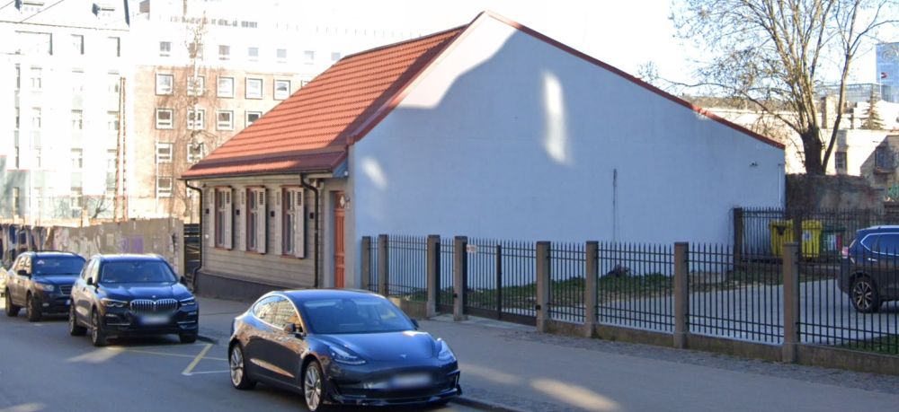
Gevonden! Inderdaad Riga, Stabu Stiela 1. Zelfs jaren geleden bevestigd door @olafkoens.bsky.social zelf 🙂. Muur heeft inmiddels een likje verf gehad.

July 28, 2025 at 10:16 PM
Gevonden! Inderdaad Riga, Stabu Stiela 1. Zelfs jaren geleden bevestigd door @olafkoens.bsky.social zelf 🙂. Muur heeft inmiddels een likje verf gehad.
Remnants from the same model were also circulated last Saturday after an alleged drone strike on a prison in El Obeid

May 15, 2025 at 12:29 PM
Remnants from the same model were also circulated last Saturday after an alleged drone strike on a prison in El Obeid
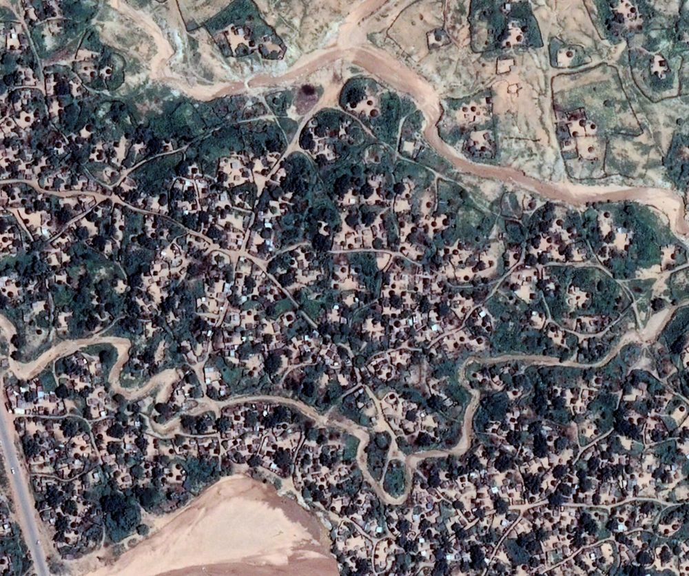
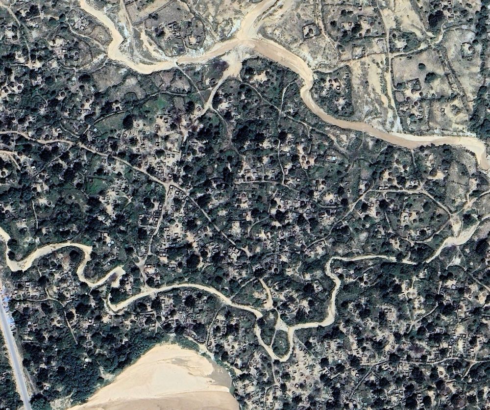
Nyala (South Darfur) has mainly smaller scale damage from munition impacts, but there's also a neighbourhood near the army base that was destroyed after RSF took over late 2023.
credit: Airbus/GE
3/3
credit: Airbus/GE
3/3
January 31, 2025 at 8:37 AM
Nyala (South Darfur) has mainly smaller scale damage from munition impacts, but there's also a neighbourhood near the army base that was destroyed after RSF took over late 2023.
credit: Airbus/GE
3/3
credit: Airbus/GE
3/3
El Fasher is tragically not the only city to have witnessed widespread destruction. El Geneina (West Darfur) might even have more extensive damage, where IDP camps were burnt down and neighbourhoods razed to the ground in 2023.
credit: Airbus/GE
2/3
credit: Airbus/GE
2/3
January 31, 2025 at 8:37 AM
El Fasher is tragically not the only city to have witnessed widespread destruction. El Geneina (West Darfur) might even have more extensive damage, where IDP camps were burnt down and neighbourhoods razed to the ground in 2023.
credit: Airbus/GE
2/3
credit: Airbus/GE
2/3
New Google Earth imagery shows the devastating toll of a war that has been raging in the city of El Fasher (North Darfur) #Sudan for almost a year now. #KeepEyesOnSudan
credit: Airbus/GE
1/3
credit: Airbus/GE
1/3
January 31, 2025 at 8:37 AM
New Google Earth imagery shows the devastating toll of a war that has been raging in the city of El Fasher (North Darfur) #Sudan for almost a year now. #KeepEyesOnSudan
credit: Airbus/GE
1/3
credit: Airbus/GE
1/3
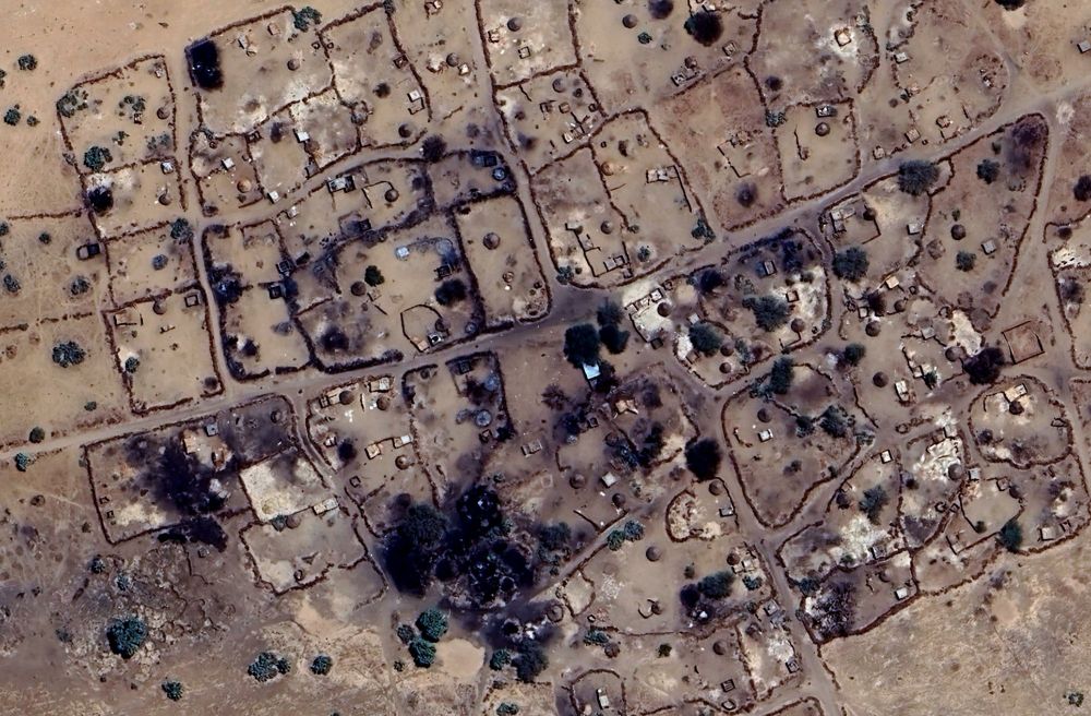
The dwellings marked B in the figure above were already burnt earlier this month.
Sentinel-2 imagery below shows additional fire damage in this area, after the block on the right was destroyed 31 May/1 Jun.
Sentinel-2 imagery below shows additional fire damage in this area, after the block on the right was destroyed 31 May/1 Jun.


July 2, 2024 at 8:21 AM
The dwellings marked B in the figure above were already burnt earlier this month.
Sentinel-2 imagery below shows additional fire damage in this area, after the block on the right was destroyed 31 May/1 Jun.
Sentinel-2 imagery below shows additional fire damage in this area, after the block on the right was destroyed 31 May/1 Jun.
While making gains in other areas – the RSF continue their offensive on El Fasher (الفاشر), leading to more devastation in the city.
Footage recorded last week shows RSF with burning property in the southern part of the city.
📍13.591227,25.356525
Footage recorded last week shows RSF with burning property in the southern part of the city.
📍13.591227,25.356525

July 2, 2024 at 8:18 AM
While making gains in other areas – the RSF continue their offensive on El Fasher (الفاشر), leading to more devastation in the city.
Footage recorded last week shows RSF with burning property in the southern part of the city.
📍13.591227,25.356525
Footage recorded last week shows RSF with burning property in the southern part of the city.
📍13.591227,25.356525
A full block of dwellings went up in flames that morning, after fires already destroyed other parts of this neighbourhood in the last couple of weeks.


May 2, 2024 at 2:33 PM
A full block of dwellings went up in flames that morning, after fires already destroyed other parts of this neighbourhood in the last couple of weeks.
RSF celebrating against the backdrop of a burning neighbourhood in El Fasher (الفاشر), #Sudan, in the morning of 29 April.
13.617611,25.380079
13.617611,25.380079


May 2, 2024 at 2:30 PM
RSF celebrating against the backdrop of a burning neighbourhood in El Fasher (الفاشر), #Sudan, in the morning of 29 April.
13.617611,25.380079
13.617611,25.380079
A smaller hamlet further up north also suffered fire damage on 4 February, as shown in imagery posted by the Abyei administration that day.
📍 9.511699,28.479319
📍 9.511699,28.479319

February 22, 2024 at 4:28 PM
A smaller hamlet further up north also suffered fire damage on 4 February, as shown in imagery posted by the Abyei administration that day.
📍 9.511699,28.479319
📍 9.511699,28.479319
Geolocation of footage showing the destruction of the market in Abathok, Abyei. The Abyei administration reported 18 civilians killed, and another 18 wounded.
Insert courtesy of Copernicus Sentinel-2.
📍 9.483633,28.552820
Insert courtesy of Copernicus Sentinel-2.
📍 9.483633,28.552820

February 22, 2024 at 2:38 PM
Geolocation of footage showing the destruction of the market in Abathok, Abyei. The Abyei administration reported 18 civilians killed, and another 18 wounded.
Insert courtesy of Copernicus Sentinel-2.
📍 9.483633,28.552820
Insert courtesy of Copernicus Sentinel-2.
📍 9.483633,28.552820
Crater-like shapes also appear at other locations around town in Sentinel-2 satellite imagery captured January 21, with the burn mark in the east being the location shown in the videos.
2/5
2/5

February 12, 2024 at 8:23 AM
Crater-like shapes also appear at other locations around town in Sentinel-2 satellite imagery captured January 21, with the burn mark in the east being the location shown in the videos.
2/5
2/5
Zurug, a town in N-Darfur #Sudan that was reportedly used as an arms trade hub by the RSF – was apparently hit by airstrikes on January the 16th.
It also seems a residential compound was hit, as 3 videos posted the next day show a burnt compound and large crater
1/5
Credit: Planet
It also seems a residential compound was hit, as 3 videos posted the next day show a burnt compound and large crater
1/5
Credit: Planet


February 12, 2024 at 8:22 AM
Zurug, a town in N-Darfur #Sudan that was reportedly used as an arms trade hub by the RSF – was apparently hit by airstrikes on January the 16th.
It also seems a residential compound was hit, as 3 videos posted the next day show a burnt compound and large crater
1/5
Credit: Planet
It also seems a residential compound was hit, as 3 videos posted the next day show a burnt compound and large crater
1/5
Credit: Planet
Geolocation of fires and smoke on the outskirts of Dilling (الدلنج), S-Kordofan, #Sudan, on 7 January.
SPLM-N and SAF allegedly took control of the town that day, while clashes with RSF reportedly took place next day. The cause of the fires is unknown.
📍 12.0408,29.6764
SPLM-N and SAF allegedly took control of the town that day, while clashes with RSF reportedly took place next day. The cause of the fires is unknown.
📍 12.0408,29.6764

February 8, 2024 at 8:59 AM
Geolocation of fires and smoke on the outskirts of Dilling (الدلنج), S-Kordofan, #Sudan, on 7 January.
SPLM-N and SAF allegedly took control of the town that day, while clashes with RSF reportedly took place next day. The cause of the fires is unknown.
📍 12.0408,29.6764
SPLM-N and SAF allegedly took control of the town that day, while clashes with RSF reportedly took place next day. The cause of the fires is unknown.
📍 12.0408,29.6764
Geolocation of RSF Deputy Commander Abdulrahim Daglo in El Geneina (الجنينة), in a video posted on 4 November, the same day videos and reports of violence in Ardamata (أردمتا) started circulating.
13.432715,22.420533
source: www.facebook.com/100095343580...
13.432715,22.420533
source: www.facebook.com/100095343580...

November 15, 2023 at 9:13 AM
Geolocation of RSF Deputy Commander Abdulrahim Daglo in El Geneina (الجنينة), in a video posted on 4 November, the same day videos and reports of violence in Ardamata (أردمتا) started circulating.
13.432715,22.420533
source: www.facebook.com/100095343580...
13.432715,22.420533
source: www.facebook.com/100095343580...
Sisi, a village in West Darfur along the main road between El Geneina and Murnei, was fully destroyed in several events in July-September.
This happened after fire attacks in Murnei end June.
📍13.192972,22.738883
Image credit: CNES / Airbus
This happened after fire attacks in Murnei end June.
📍13.192972,22.738883
Image credit: CNES / Airbus


October 24, 2023 at 3:30 PM
Sisi, a village in West Darfur along the main road between El Geneina and Murnei, was fully destroyed in several events in July-September.
This happened after fire attacks in Murnei end June.
📍13.192972,22.738883
Image credit: CNES / Airbus
This happened after fire attacks in Murnei end June.
📍13.192972,22.738883
Image credit: CNES / Airbus
New events may also include fires that have happened more than a month ago.
This morning for example, I detected damage in Bara (below 13.183675,22.273712), a town along the Geneina-Misterei road, also both localities that were targeted with fire in the past half year.
3/5
This morning for example, I detected damage in Bara (below 13.183675,22.273712), a town along the Geneina-Misterei road, also both localities that were targeted with fire in the past half year.
3/5


October 18, 2023 at 2:14 PM
New events may also include fires that have happened more than a month ago.
This morning for example, I detected damage in Bara (below 13.183675,22.273712), a town along the Geneina-Misterei road, also both localities that were targeted with fire in the past half year.
3/5
This morning for example, I detected damage in Bara (below 13.183675,22.273712), a town along the Geneina-Misterei road, also both localities that were targeted with fire in the past half year.
3/5
More fire events are under investigation, and Sudan Witness will update the map regularly to reflect new findings.
The last verified events were in Misterei, targeted for the 2nd time since Apr. Sentinel-2 imagery captured this month show large-scale damage.
2/5
The last verified events were in Misterei, targeted for the 2nd time since Apr. Sentinel-2 imagery captured this month show large-scale damage.
2/5

October 18, 2023 at 2:10 PM
More fire events are under investigation, and Sudan Witness will update the map regularly to reflect new findings.
The last verified events were in Misterei, targeted for the 2nd time since Apr. Sentinel-2 imagery captured this month show large-scale damage.
2/5
The last verified events were in Misterei, targeted for the 2nd time since Apr. Sentinel-2 imagery captured this month show large-scale damage.
2/5
Honoured to work with the Centre for Information Resilience to investigate and map village fires in Darfur/#Sudan to expose human rights abuses.
Today, CIR's Sudan Witness launched an interactive map providing a visual display with at least 68 villages that were damaged by fire since April.
1/x
Today, CIR's Sudan Witness launched an interactive map providing a visual display with at least 68 villages that were damaged by fire since April.
1/x

October 18, 2023 at 2:08 PM
Honoured to work with the Centre for Information Resilience to investigate and map village fires in Darfur/#Sudan to expose human rights abuses.
Today, CIR's Sudan Witness launched an interactive map providing a visual display with at least 68 villages that were damaged by fire since April.
1/x
Today, CIR's Sudan Witness launched an interactive map providing a visual display with at least 68 villages that were damaged by fire since April.
1/x
Fire damage in Kongi, Central Darfur. FIRMS heat anomalies on 19 May.
The Airbus imagery below was captured on 26 May
13.380568, 23.108515
The Airbus imagery below was captured on 26 May
13.380568, 23.108515

October 12, 2023 at 12:26 PM
Fire damage in Kongi, Central Darfur. FIRMS heat anomalies on 19 May.
The Airbus imagery below was captured on 26 May
13.380568, 23.108515
The Airbus imagery below was captured on 26 May
13.380568, 23.108515
Very clear fire damage and white ash is visible in Umm Tereina, on Airbus imagery from 4 May.
Imagery comparison with Sentinel-2 and Planet shows that fires happened between 1-3 May.
12.302871,25.140561
Imagery comparison with Sentinel-2 and Planet shows that fires happened between 1-3 May.
12.302871,25.140561

October 12, 2023 at 12:20 PM
Very clear fire damage and white ash is visible in Umm Tereina, on Airbus imagery from 4 May.
Imagery comparison with Sentinel-2 and Planet shows that fires happened between 1-3 May.
12.302871,25.140561
Imagery comparison with Sentinel-2 and Planet shows that fires happened between 1-3 May.
12.302871,25.140561
Shataya (or Kashete), South Darfur. FIRMS heat anomalies on 21 April. Imagery captured on 4 May by Airbus
12.080118,25.20252
12.080118,25.20252

October 12, 2023 at 12:20 PM
Shataya (or Kashete), South Darfur. FIRMS heat anomalies on 21 April. Imagery captured on 4 May by Airbus
12.080118,25.20252
12.080118,25.20252
Sekali, South Darfur, likely date of fire April 29. Satellite imagery captured by Airbus 4 May shows white spots, likely ash from the fires that happened just days ago.
12.3057478, 25.0783753
12.3057478, 25.0783753

October 12, 2023 at 12:18 PM
Sekali, South Darfur, likely date of fire April 29. Satellite imagery captured by Airbus 4 May shows white spots, likely ash from the fires that happened just days ago.
12.3057478, 25.0783753
12.3057478, 25.0783753
Umsalayallah, South Darfur. Damage visible on Sentinel-2 imagery between 16-19 April. Airbus imagery captured 4 May.
12.315285,25.069358
12.315285,25.069358
October 12, 2023 at 12:14 PM
Umsalayallah, South Darfur. Damage visible on Sentinel-2 imagery between 16-19 April. Airbus imagery captured 4 May.
12.315285,25.069358
12.315285,25.069358
A few other villages in Darfur impacted by fire damage over the last couple of months:
Gereida (قريضة), South Darfur on 16 April. This image was captured by Airbus a few days later, on 21 April.
11.261676,25.151591
Gereida (قريضة), South Darfur on 16 April. This image was captured by Airbus a few days later, on 21 April.
11.261676,25.151591

October 12, 2023 at 12:13 PM
A few other villages in Darfur impacted by fire damage over the last couple of months:
Gereida (قريضة), South Darfur on 16 April. This image was captured by Airbus a few days later, on 21 April.
11.261676,25.151591
Gereida (قريضة), South Darfur on 16 April. This image was captured by Airbus a few days later, on 21 April.
11.261676,25.151591