


Simon Lee
@simonleewx.com
Lecturer in Atmospheric Science, University of St Andrews. Large-scale weather & climate variability, prediction & change. simonleewx.com
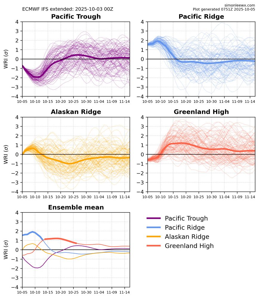
North American weather regime forecasts have shifted from Greenland High toward Alaskan Ridge. This is consistent with forecasts of the forthcoming SSW shifting toward an event dominated by wave reflection and a quick reintensification of the vortex.
simonleewx.com/ecmwf_north_...
simonleewx.com/ecmwf_north_...

November 24, 2025 at 5:18 PM
North American weather regime forecasts have shifted from Greenland High toward Alaskan Ridge. This is consistent with forecasts of the forthcoming SSW shifting toward an event dominated by wave reflection and a quick reintensification of the vortex.
simonleewx.com/ecmwf_north_...
simonleewx.com/ecmwf_north_...
Just added "chiclet plots" to my website, showing the North American weather regime of the ensemble mean for the past 90 runs of the subseasonal NCEP GEFS & ECMWF IFS
GEFS: simonleewx.com/gefs_north_a...
IFS: simonleewx.com/ecmwf_north_...
GEFS: simonleewx.com/gefs_north_a...
IFS: simonleewx.com/ecmwf_north_...


November 21, 2025 at 4:14 PM
Just added "chiclet plots" to my website, showing the North American weather regime of the ensemble mean for the past 90 runs of the subseasonal NCEP GEFS & ECMWF IFS
GEFS: simonleewx.com/gefs_north_a...
IFS: simonleewx.com/ecmwf_north_...
GEFS: simonleewx.com/gefs_north_a...
IFS: simonleewx.com/ecmwf_north_...
A stunning Cumulonimbus
snow shower cloud out over the North Sea in the northerly flow this afternoon. Dry and sunny in St Andrews as we’re sheltered by the Cairngorms to the north!
snow shower cloud out over the North Sea in the northerly flow this afternoon. Dry and sunny in St Andrews as we’re sheltered by the Cairngorms to the north!

November 20, 2025 at 4:10 PM
A stunning Cumulonimbus
snow shower cloud out over the North Sea in the northerly flow this afternoon. Dry and sunny in St Andrews as we’re sheltered by the Cairngorms to the north!
snow shower cloud out over the North Sea in the northerly flow this afternoon. Dry and sunny in St Andrews as we’re sheltered by the Cairngorms to the north!
With the imminent weak polar vortex/potential SSW, one similar recent(ish) year is 1996/97, which saw a very weak early season vortex (date-record weak U10-60 in Nov). 96/97 also had an established easterly QBO & cool ENSO Neutral/borderline La Niña. Extremely strong late-season vortex ensued.

November 19, 2025 at 6:40 PM
With the imminent weak polar vortex/potential SSW, one similar recent(ish) year is 1996/97, which saw a very weak early season vortex (date-record weak U10-60 in Nov). 96/97 also had an established easterly QBO & cool ENSO Neutral/borderline La Niña. Extremely strong late-season vortex ensued.
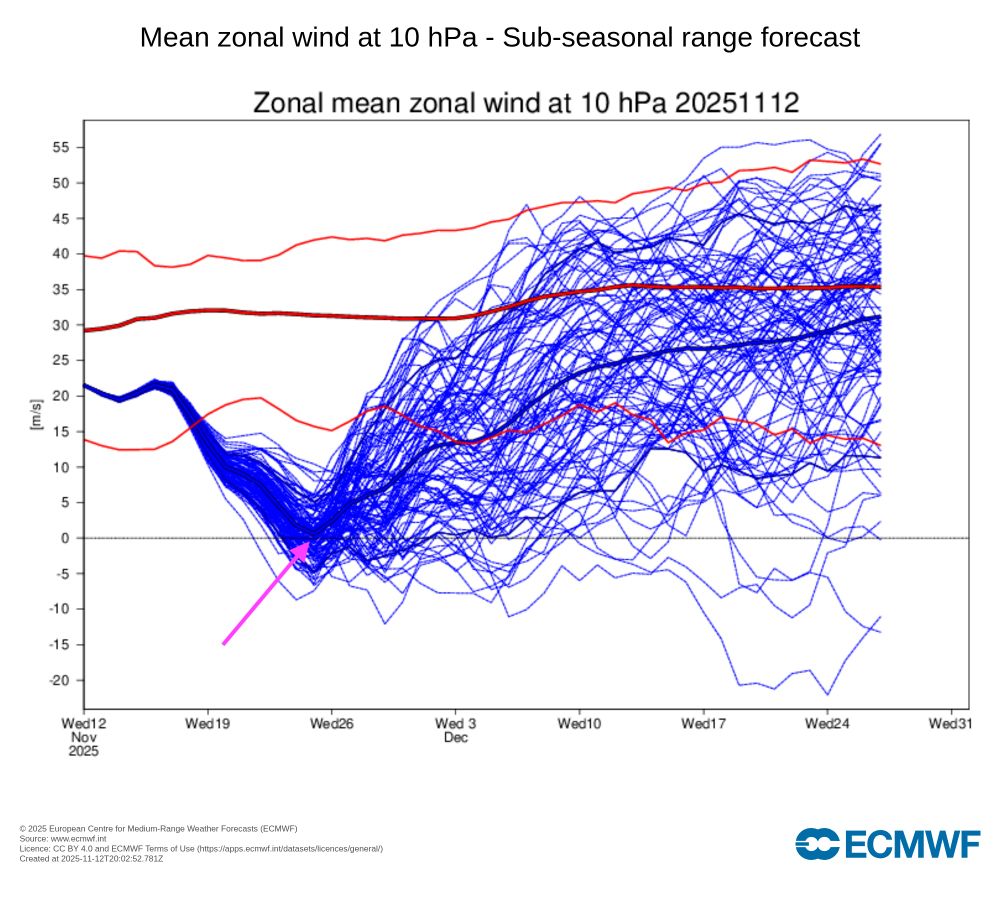
The ensemble mean of today's IFS subseasonal forecast now predicts the earliest major sudden stratospheric warming in reliable records, beating 28 November 1968.
Will this verify? 👀
charts.ecmwf.int/products/ext...
Will this verify? 👀
charts.ecmwf.int/products/ext...

November 13, 2025 at 8:17 PM
The ensemble mean of today's IFS subseasonal forecast now predicts the earliest major sudden stratospheric warming in reliable records, beating 28 November 1968.
Will this verify? 👀
charts.ecmwf.int/products/ext...
Will this verify? 👀
charts.ecmwf.int/products/ext...
The ensemble mean from today's IFS subseasonal run almost predicts the earliest major sudden stratospheric warming on record 😮
Will be interesting to see if this signal progresses as it is just on the cusp of typical SSW prediction lead-times – daily runs of 101 members can still vary a fair bit
Will be interesting to see if this signal progresses as it is just on the cusp of typical SSW prediction lead-times – daily runs of 101 members can still vary a fair bit
November 12, 2025 at 8:32 PM
The ensemble mean from today's IFS subseasonal run almost predicts the earliest major sudden stratospheric warming on record 😮
Will be interesting to see if this signal progresses as it is just on the cusp of typical SSW prediction lead-times – daily runs of 101 members can still vary a fair bit
Will be interesting to see if this signal progresses as it is just on the cusp of typical SSW prediction lead-times – daily runs of 101 members can still vary a fair bit
Not the favoured outcome by any means, and I’m mostly posting this for fun (and my own interest in “unseen” model extremes), but the GFS 18Z has an historic major SSW on 26 November.
This would be the earliest in reliable records, beating 28 Nov 1968.
Not a forecast — just for interest!
This would be the earliest in reliable records, beating 28 Nov 1968.
Not a forecast — just for interest!

November 10, 2025 at 11:56 PM
Not the favoured outcome by any means, and I’m mostly posting this for fun (and my own interest in “unseen” model extremes), but the GFS 18Z has an historic major SSW on 26 November.
This would be the earliest in reliable records, beating 28 Nov 1968.
Not a forecast — just for interest!
This would be the earliest in reliable records, beating 28 Nov 1968.
Not a forecast — just for interest!
06Z GFS has remarkably persistent Greenland blocking for the full run, and a very weak stratospheric vortex by the end of it too. Posting this just for fun, but falls within what seems to be the range of possible outcomes based on recent modelling.
November 8, 2025 at 2:45 PM
06Z GFS has remarkably persistent Greenland blocking for the full run, and a very weak stratospheric vortex by the end of it too. Posting this just for fun, but falls within what seems to be the range of possible outcomes based on recent modelling.
Take this example from BBC Weather: the "forecast" (including the icon) is "light rain", but the probability of rain actually falling is 35% and described only as a "chance". That's unclear to me.

October 23, 2025 at 9:20 AM
Take this example from BBC Weather: the "forecast" (including the icon) is "light rain", but the probability of rain actually falling is 35% and described only as a "chance". That's unclear to me.
Storm Amy really sticks out in an otherwise dominantly slowly-varying & anticyclonic month (until today, that is!). Pressure data from northeast Fife (~10m above sea level)

October 19, 2025 at 12:06 PM
Storm Amy really sticks out in an otherwise dominantly slowly-varying & anticyclonic month (until today, that is!). Pressure data from northeast Fife (~10m above sea level)
Two headlines for the same BBC News article. One makes it much clearer this is a reference to global-mean temperatures (not UK-mean). Both unclear that they refer to 2°C total warming since preindustrial, not an additional 2°C from where we are today.


October 15, 2025 at 6:00 PM
Two headlines for the same BBC News article. One makes it much clearer this is a reference to global-mean temperatures (not UK-mean). Both unclear that they refer to 2°C total warming since preindustrial, not an additional 2°C from where we are today.
Even sunny St Andrews isn't immune from the anticyclonic gloom today ☁️

October 14, 2025 at 2:55 PM
Even sunny St Andrews isn't immune from the anticyclonic gloom today ☁️
Global and regional climate in 2024 🌡️📈
The latest annual assessment from the Hadley Centre @metoffice.gov.uk published in @rmets.org Weather
Free to read: doi.org/10.1002/wea....
The latest annual assessment from the Hadley Centre @metoffice.gov.uk published in @rmets.org Weather
Free to read: doi.org/10.1002/wea....

October 11, 2025 at 2:45 PM
Global and regional climate in 2024 🌡️📈
The latest annual assessment from the Hadley Centre @metoffice.gov.uk published in @rmets.org Weather
Free to read: doi.org/10.1002/wea....
The latest annual assessment from the Hadley Centre @metoffice.gov.uk published in @rmets.org Weather
Free to read: doi.org/10.1002/wea....
Storm Floris at 12 UTC 4 August 2025 vs. Storm Amy at 18 UTC 3 October 2025.
Strikingly similar synoptic patterns and locations of the two storms separated by only two months!
Strikingly similar synoptic patterns and locations of the two storms separated by only two months!


October 7, 2025 at 10:14 PM
Storm Floris at 12 UTC 4 August 2025 vs. Storm Amy at 18 UTC 3 October 2025.
Strikingly similar synoptic patterns and locations of the two storms separated by only two months!
Strikingly similar synoptic patterns and locations of the two storms separated by only two months!
The west–east temperature contrast across North America is a hallmark of the Pacific Ridge regime, which is currently at 1.5–2 standard deviations simonleewx.com/ecmwf_north_...
October 5, 2025 at 6:23 PM
The west–east temperature contrast across North America is a hallmark of the Pacific Ridge regime, which is currently at 1.5–2 standard deviations simonleewx.com/ecmwf_north_...
Evolution of #StormAmy from 18 UTC 1 October through 12 UTC 4 October per Met Office analyses. The initial disturbance was perfectly phased with a wave in the jet, undergoing explosive cyclogenesis & evolving into a powerful Shapiro–Keyser cyclone, setting low pressure records for the time of year.
October 4, 2025 at 3:12 PM
Evolution of #StormAmy from 18 UTC 1 October through 12 UTC 4 October per Met Office analyses. The initial disturbance was perfectly phased with a wave in the jet, undergoing explosive cyclogenesis & evolving into a powerful Shapiro–Keyser cyclone, setting low pressure records for the time of year.
#StormAmy down to 952 hPa over Outer Hebrides on 18Z analysis from the Met Office, which continues the Shapiro-Keyser structure from the 12Z analysis (frontal fracture)

October 3, 2025 at 7:31 PM
#StormAmy down to 952 hPa over Outer Hebrides on 18Z analysis from the Met Office, which continues the Shapiro-Keyser structure from the 12Z analysis (frontal fracture)

Storm Amy down to 964 hPa at 12 UTC, with the Met Office analysis adopting the Shapiro–Keyser cyclone model with a frontal fracture region. S-K cyclones are typically among the more intense. Sting jets can form on S-K cyclones but a sting jet is not necessary for severe wind gusts.

October 3, 2025 at 2:19 PM
Storm Amy down to 964 hPa at 12 UTC, with the Met Office analysis adopting the Shapiro–Keyser cyclone model with a frontal fracture region. S-K cyclones are typically among the more intense. Sting jets can form on S-K cyclones but a sting jet is not necessary for severe wind gusts.

The October issue of @rmets.org Weather is now online!
Featuring...
– The damaging MCS in southern England in October 2022
– Turbulent kinetic energy in Shenzhen, China
– Summer 2025 UK seasonal weather summary
+ book reviews & all the regular content!
rmets.onlinelibrary.wiley.com/toc/14778696...
Featuring...
– The damaging MCS in southern England in October 2022
– Turbulent kinetic energy in Shenzhen, China
– Summer 2025 UK seasonal weather summary
+ book reviews & all the regular content!
rmets.onlinelibrary.wiley.com/toc/14778696...
October 2, 2025 at 10:31 AM
The October issue of @rmets.org Weather is now online!
Featuring...
– The damaging MCS in southern England in October 2022
– Turbulent kinetic energy in Shenzhen, China
– Summer 2025 UK seasonal weather summary
+ book reviews & all the regular content!
rmets.onlinelibrary.wiley.com/toc/14778696...
Featuring...
– The damaging MCS in southern England in October 2022
– Turbulent kinetic energy in Shenzhen, China
– Summer 2025 UK seasonal weather summary
+ book reviews & all the regular content!
rmets.onlinelibrary.wiley.com/toc/14778696...
What an odd-looking NHC forecast cone

October 1, 2025 at 7:31 AM
What an odd-looking NHC forecast cone
It has been quite a mathsy week! Kicked off our third year (Junior Honours level) module with some rotating fluid dynamics 🌀
It all looks rather complex until scale analysis and several justifiable approximations make things quite a bit simpler 😀
(with thanks to Marshall & Plumb’s textbook)
It all looks rather complex until scale analysis and several justifiable approximations make things quite a bit simpler 😀
(with thanks to Marshall & Plumb’s textbook)

September 18, 2025 at 1:28 PM
It has been quite a mathsy week! Kicked off our third year (Junior Honours level) module with some rotating fluid dynamics 🌀
It all looks rather complex until scale analysis and several justifiable approximations make things quite a bit simpler 😀
(with thanks to Marshall & Plumb’s textbook)
It all looks rather complex until scale analysis and several justifiable approximations make things quite a bit simpler 😀
(with thanks to Marshall & Plumb’s textbook)
This photo is from the same location in June 2024 when the reservoir was full and overflowing.

September 16, 2025 at 5:17 PM
This photo is from the same location in June 2024 when the reservoir was full and overflowing.
Extremely low water levels today at Thruscross Reservoir, North Yorkshire (top reservoir in the Washburn Valley chain) 😯
Sustained wet conditions will be needed to refill reservoir stocks — a few rainy days might green things up, but much more will be needed to reverse this deficit.
Sustained wet conditions will be needed to refill reservoir stocks — a few rainy days might green things up, but much more will be needed to reverse this deficit.

September 16, 2025 at 5:14 PM
Extremely low water levels today at Thruscross Reservoir, North Yorkshire (top reservoir in the Washburn Valley chain) 😯
Sustained wet conditions will be needed to refill reservoir stocks — a few rainy days might green things up, but much more will be needed to reverse this deficit.
Sustained wet conditions will be needed to refill reservoir stocks — a few rainy days might green things up, but much more will be needed to reverse this deficit.