


Raúl Nanclares 🍜
@rnanclares.fosstodon.org.ap.brid.gy
Geoinformatics. Remote sensing. PostGIS. SQL/R/Python. Data laundering. FOSS4G. Osgeo charter member. Distros: :fedora: :debian: :popos:
¯\\_(ツ)_/¯
[bridged from https://fosstodon.org/@rnanclares on the fediverse by https://fed.brid.gy/ ]
¯\\_(ツ)_/¯
[bridged from https://fosstodon.org/@rnanclares on the fediverse by https://fed.brid.gy/ ]
Reposted by Raúl Nanclares 🍜
Welcome to the biggest GIS Marketing day ever - #gisday - where we try for the 40th year in a row to tell people why what we do is important and have those same people go "just drawing on a computer". Then everyone drinks afterwards.
November 19, 2025 at 1:21 PM
Welcome to the biggest GIS Marketing day ever - #gisday - where we try for the 40th year in a row to tell people why what we do is important and have those same people go "just drawing on a computer". Then everyone drinks afterwards.
Reposted by Raúl Nanclares 🍜

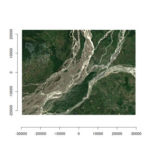
#30DayMapChallenge Day 20: Water 🌊
No time for complexity today, so I made Invearth. By simply flipping the hillshade to Southeast in #qgis with the #mapzen Global Terrain layer, the Himalayas became the deepest trench and oceans turned into habitable land. A […]
[Original post on fosstodon.org]
No time for complexity today, so I made Invearth. By simply flipping the hillshade to Southeast in #qgis with the #mapzen Global Terrain layer, the Himalayas became the deepest trench and oceans turned into habitable land. A […]
[Original post on fosstodon.org]

November 20, 2025 at 6:36 AM
#30DayMapChallenge Day 20: Water 🌊
No time for complexity today, so I made Invearth. By simply flipping the hillshade to Southeast in #qgis with the #mapzen Global Terrain layer, the Himalayas became the deepest trench and oceans turned into habitable land. A […]
[Original post on fosstodon.org]
No time for complexity today, so I made Invearth. By simply flipping the hillshade to Southeast in #qgis with the #mapzen Global Terrain layer, the Himalayas became the deepest trench and oceans turned into habitable land. A […]
[Original post on fosstodon.org]
Reposted by Raúl Nanclares 🍜

Today I am stepping down from my role as the CEO of #mastodon. Though this has been in the works for a while, I can't say I've fully processed how I feel about it. There is a bittersweet part to it, and I think I will miss it, but it also felt necessary. It feels like a goodbye, but it isn't—I […]
Original post on mastodon.social
mastodon.social
November 18, 2025 at 8:46 AM
Today I am stepping down from my role as the CEO of #mastodon. Though this has been in the works for a while, I can't say I've fully processed how I feel about it. There is a bittersweet part to it, and I think I will miss it, but it also felt necessary. It feels like a goodbye, but it isn't—I […]
Reposted by Raúl Nanclares 🍜


November 16, 2025 at 2:59 AM
Reposted by Raúl Nanclares 🍜

Working with raster + vector together in Python? 🗺️🌍🐍
Chapter 5 of geocompx talks about:
- Cropping & masking rasters with vectors
- Extracting raster values via vector data
- Raster ↔️ vector conversion (polygonize & rasterize)
👉 https://py.geocompx.org/05-raster-vector
#geopython #python […]
Chapter 5 of geocompx talks about:
- Cropping & masking rasters with vectors
- Extracting raster values via vector data
- Raster ↔️ vector conversion (polygonize & rasterize)
👉 https://py.geocompx.org/05-raster-vector
#geopython #python […]
Original post on fosstodon.org
fosstodon.org
November 2, 2025 at 2:00 PM
Working with raster + vector together in Python? 🗺️🌍🐍
Chapter 5 of geocompx talks about:
- Cropping & masking rasters with vectors
- Extracting raster values via vector data
- Raster ↔️ vector conversion (polygonize & rasterize)
👉 https://py.geocompx.org/05-raster-vector
#geopython #python […]
Chapter 5 of geocompx talks about:
- Cropping & masking rasters with vectors
- Extracting raster values via vector data
- Raster ↔️ vector conversion (polygonize & rasterize)
👉 https://py.geocompx.org/05-raster-vector
#geopython #python […]

Reposted by Raúl Nanclares 🍜

I'm in a #github internal group for high-profile FOSS projects (due to @leaflet having a few kilo-stars), and the second most-wanted feature is "plz allow us to disable copilot reviews", with the most-wanted feature being "plz allow us to block issues/PRs […]
[Original post on mastodon.social]
[Original post on mastodon.social]


October 24, 2025 at 4:17 PM
I'm in a #github internal group for high-profile FOSS projects (due to @leaflet having a few kilo-stars), and the second most-wanted feature is "plz allow us to disable copilot reviews", with the most-wanted feature being "plz allow us to block issues/PRs […]
[Original post on mastodon.social]
[Original post on mastodon.social]
Reposted by Raúl Nanclares 🍜

The devastation of #gaza #storymap tells the grim tale in a very visual way with #earthobservation https://www.bbc.co.uk/news/resources/idt-217c6a28-4a90-4d47-a91c-13113a7dc7db

Gaza war in maps and satellite images - BBC News
A visual guide to the Gaza Strip since Israel began its military response to Hamas's attacks on 7 October - mapping the destruction, evacuation orders and how things have changed
www.bbc.co.uk
October 21, 2025 at 1:46 PM
The devastation of #gaza #storymap tells the grim tale in a very visual way with #earthobservation https://www.bbc.co.uk/news/resources/idt-217c6a28-4a90-4d47-a91c-13113a7dc7db
🚨 A Chinese APT hid inside ArcGIS for over a year.
They turned a legit Java extension into a web shell.
🔑 Added a hardcoded key → exclusive access
💾 Hid it in backups → survived restores
https://thehackernews.com/2025/10/chinese-hackers-exploit-arcgis-server.html
They turned a legit Java extension into a web shell.
🔑 Added a hardcoded key → exclusive access
💾 Hid it in backups → survived restores
https://thehackernews.com/2025/10/chinese-hackers-exploit-arcgis-server.html

Chinese Hackers Exploit ArcGIS Server as Backdoor for Over a Year
Threat actors with ties to China have been attributed to a novel campaign that compromised an ArcGIS system and turned it into a backdoor for more than a year. The activity, per ReliaQuest, is the handiwork of a Chinese state-sponsored hacking group called Flax Typhoon, which is also tracked as Ethereal Panda and RedJuliett. According to the U.S. government, it's assessed to be a publicly-traded
thehackernews.com
October 15, 2025 at 9:28 AM
🚨 A Chinese APT hid inside ArcGIS for over a year.
They turned a legit Java extension into a web shell.
🔑 Added a hardcoded key → exclusive access
💾 Hid it in backups → survived restores
https://thehackernews.com/2025/10/chinese-hackers-exploit-arcgis-server.html
They turned a legit Java extension into a web shell.
🔑 Added a hardcoded key → exclusive access
💾 Hid it in backups → survived restores
https://thehackernews.com/2025/10/chinese-hackers-exploit-arcgis-server.html
I've slept 24 hours in the last week. Wouldn't recommend. Post septoplasry week probably in my top 3 worsrt time of my life.
Let's see if it was worth it.
Let's see if it was worth it.
October 15, 2025 at 9:25 AM
I've slept 24 hours in the last week. Wouldn't recommend. Post septoplasry week probably in my top 3 worsrt time of my life.
Let's see if it was worth it.
Let's see if it was worth it.
Reposted by Raúl Nanclares 🍜
New post by David O’Sullivan:
“Raster really is faster (and vaster), but vector just seems more corrector.”
Part 1A of a series revisiting ideas from Geographic Information Analysis: fractals, raster vs vector, and R code.
👉 […]
[Original post on fosstodon.org]
“Raster really is faster (and vaster), but vector just seems more corrector.”
Part 1A of a series revisiting ideas from Geographic Information Analysis: fractals, raster vs vector, and R code.
👉 […]
[Original post on fosstodon.org]


October 1, 2025 at 1:01 PM
New post by David O’Sullivan:
“Raster really is faster (and vaster), but vector just seems more corrector.”
Part 1A of a series revisiting ideas from Geographic Information Analysis: fractals, raster vs vector, and R code.
👉 […]
[Original post on fosstodon.org]
“Raster really is faster (and vaster), but vector just seems more corrector.”
Part 1A of a series revisiting ideas from Geographic Information Analysis: fractals, raster vs vector, and R code.
👉 […]
[Original post on fosstodon.org]
Reposted by Raúl Nanclares 🍜
🎥 I've published a video based on my #geomobnl talk in Eindhoven on 18 Sept on #digitalsovereignty & #opensource for geo, covering procurement, policy, and community-driven development.
Watch here: https://youtu.be/0u6tPM-USHY
💬 Feel free to share your comments.
#qgis #osgeo #ogc
Watch here: https://youtu.be/0u6tPM-USHY
💬 Feel free to share your comments.
#qgis #osgeo #ogc
September 28, 2025 at 8:27 AM
🎥 I've published a video based on my #geomobnl talk in Eindhoven on 18 Sept on #digitalsovereignty & #opensource for geo, covering procurement, policy, and community-driven development.
Watch here: https://youtu.be/0u6tPM-USHY
💬 Feel free to share your comments.
#qgis #osgeo #ogc
Watch here: https://youtu.be/0u6tPM-USHY
💬 Feel free to share your comments.
#qgis #osgeo #ogc
Reposted by Raúl Nanclares 🍜

Johnson's Mexico. Entered ... 1867. (inset) Isthmus of Tehuantepec. Johnson's Central America. (inset) Isthmus of Panama. Entered ... 1867. https://www.davidrumsey.com/luna/servlet/detail/RUMSEY~8~1~219452~5504628
#map #maps #historicalmaps
#map #maps #historicalmaps

September 28, 2025 at 4:00 PM
Johnson's Mexico. Entered ... 1867. (inset) Isthmus of Tehuantepec. Johnson's Central America. (inset) Isthmus of Panama. Entered ... 1867. https://www.davidrumsey.com/luna/servlet/detail/RUMSEY~8~1~219452~5504628
#map #maps #historicalmaps
#map #maps #historicalmaps
Reposted by Raúl Nanclares 🍜

Pretty cool: [email protected] is the 1,955 most followed account according to https://most-followed-mastodon-accounts.stefanhayden.com/?q=qgis
#qgis #osgeo #gischat
#qgis #osgeo #gischat

September 27, 2025 at 8:23 PM
Pretty cool: [email protected] is the 1,955 most followed account according to https://most-followed-mastodon-accounts.stefanhayden.com/?q=qgis
#qgis #osgeo #gischat
#qgis #osgeo #gischat
Reposted by Raúl Nanclares 🍜
🌍Exploring Sentinel-2 with the Copernicus Data Space Ecosystem (CDSE)?
Hugh Graham’s guide with vrtility in #rstats. Includes authentication & query of imagery and building cloud-free composites […]
[Original post on fosstodon.org]
Hugh Graham’s guide with vrtility in #rstats. Includes authentication & query of imagery and building cloud-free composites […]
[Original post on fosstodon.org]

September 24, 2025 at 1:22 PM
🌍Exploring Sentinel-2 with the Copernicus Data Space Ecosystem (CDSE)?
Hugh Graham’s guide with vrtility in #rstats. Includes authentication & query of imagery and building cloud-free composites […]
[Original post on fosstodon.org]
Hugh Graham’s guide with vrtility in #rstats. Includes authentication & query of imagery and building cloud-free composites […]
[Original post on fosstodon.org]
Reposted by Raúl Nanclares 🍜
Finally got the latest Geohipster Interview done. Man that took about a month longer than I wanted. Publishing happens tomorrow.
September 22, 2025 at 5:04 PM
Finally got the latest Geohipster Interview done. Man that took about a month longer than I wanted. Publishing happens tomorrow.
Reposted by Raúl Nanclares 🍜

El pasado 10 de septiembre, el mismo día en que a Charlie Kirk le sellaban el pasaporte al otro barrio solo para que luego absolutamente todos los medios conservadores y liberales no dijesen que bajo ningún concepto se puede justificar el asesinato de alguien solo por decir cosas que no nos […]
Original post on neopaquita.es
neopaquita.es
September 21, 2025 at 11:22 AM
El pasado 10 de septiembre, el mismo día en que a Charlie Kirk le sellaban el pasaporte al otro barrio solo para que luego absolutamente todos los medios conservadores y liberales no dijesen que bajo ningún concepto se puede justificar el asesinato de alguien solo por decir cosas que no nos […]
Reposted by Raúl Nanclares 🍜
🚀 Book in progress: Spatial Data Visualization with tmap
A practical guide to creating clear thematic maps in R with the tmap package.
Covers everything from loading data to interactive and animated maps, with reproducible code and examples.
Read online […]
[Original post on fosstodon.org]
A practical guide to creating clear thematic maps in R with the tmap package.
Covers everything from loading data to interactive and animated maps, with reproducible code and examples.
Read online […]
[Original post on fosstodon.org]


September 14, 2025 at 1:00 PM
🚀 Book in progress: Spatial Data Visualization with tmap
A practical guide to creating clear thematic maps in R with the tmap package.
Covers everything from loading data to interactive and animated maps, with reproducible code and examples.
Read online […]
[Original post on fosstodon.org]
A practical guide to creating clear thematic maps in R with the tmap package.
Covers everything from loading data to interactive and animated maps, with reproducible code and examples.
Read online […]
[Original post on fosstodon.org]
Reposted by Raúl Nanclares 🍜
It warms my newly rebuilt heart to see the QGIS-US group gaining some traction. Slowly. Anyway - VPAT info is up on the website: https://www.qgis-us.org/2025/09/12/vpat/ #vpat #paperwork #qgis
VPAT | QGIS US
www.qgis-us.org
September 12, 2025 at 1:15 PM
It warms my newly rebuilt heart to see the QGIS-US group gaining some traction. Slowly. Anyway - VPAT info is up on the website: https://www.qgis-us.org/2025/09/12/vpat/ #vpat #paperwork #qgis
Reposted by Raúl Nanclares 🍜

For everyone saying political violence has no place in this country…
Remember two Democratic legislators were shot in Minnesota just this year.
And America shrugged and moved on.
Remember two Democratic legislators were shot in Minnesota just this year.
And America shrugged and moved on.
September 10, 2025 at 8:53 PM
For everyone saying political violence has no place in this country…
Remember two Democratic legislators were shot in Minnesota just this year.
And America shrugged and moved on.
Remember two Democratic legislators were shot in Minnesota just this year.
And America shrugged and moved on.
Reposted by Raúl Nanclares 🍜

it appears the same attackers also compromised the JavaScript package duckdb (~350k downloads a week):
https://www.aikido.dev/blog/duckdb-npm-packages-compromised
https://www.aikido.dev/blog/duckdb-npm-packages-compromised

duckdb npm packages compromised
The popular package duckdb was compromised by same attackers that hit debug and chalk
www.aikido.dev
September 9, 2025 at 4:16 PM
it appears the same attackers also compromised the JavaScript package duckdb (~350k downloads a week):
https://www.aikido.dev/blog/duckdb-npm-packages-compromised
https://www.aikido.dev/blog/duckdb-npm-packages-compromised
Reposted by Raúl Nanclares 🍜
📢 Materials from the OpenGeoHub Summer School 2025 (“Data Science for Earth Observation”) by Krzysztof Dyba are now online.
Discuss how to access, process, and analyze satellite data with #rstats.
👉 https://github.com/kadyb/OGH2025
#rspatial #remotesensing #gischat
Discuss how to access, process, and analyze satellite data with #rstats.
👉 https://github.com/kadyb/OGH2025
#rspatial #remotesensing #gischat


September 10, 2025 at 2:01 PM
📢 Materials from the OpenGeoHub Summer School 2025 (“Data Science for Earth Observation”) by Krzysztof Dyba are now online.
Discuss how to access, process, and analyze satellite data with #rstats.
👉 https://github.com/kadyb/OGH2025
#rspatial #remotesensing #gischat
Discuss how to access, process, and analyze satellite data with #rstats.
👉 https://github.com/kadyb/OGH2025
#rspatial #remotesensing #gischat
September 10, 2025 at 5:48 AM
pg_duckdb sounds pretty amazing... let see if it lives up to the hype
https://motherduck.com/blog/pg-duckdb-release/
#postgresql #duckdb #dbfusion #fusion
https://motherduck.com/blog/pg-duckdb-release/
#postgresql #duckdb #dbfusion #fusion

Announcing Pg_duckdb Version 1.0 - MotherDuck Blog
PostgreSQL gets a DuckDB-flavored power-up for faster analytical queries without ever leaving Postgres. | Reading time: 6 min read
motherduck.com
September 5, 2025 at 8:03 AM
pg_duckdb sounds pretty amazing... let see if it lives up to the hype
https://motherduck.com/blog/pg-duckdb-release/
#postgresql #duckdb #dbfusion #fusion
https://motherduck.com/blog/pg-duckdb-release/
#postgresql #duckdb #dbfusion #fusion