


Ragnar Heiðar Þrastarson
@ragnarheidar.bsky.social
Mapmaker, mountaineer and GIS Coordinator of the Icelandic Met Office. Open Source Geospatial all the way!
Currently sponsoring:
QGIS | OSGeo | Even Rouault
Currently sponsoring:
QGIS | OSGeo | Even Rouault
November is my favorite time to look at #Sentinel2 images of Iceland. All the long shadows draw out the landscape is we are just about to hit the dark months in the visual spectrum acquisitions.
#iceland #glacier #remotesensing #copernicus
#iceland #glacier #remotesensing #copernicus


November 14, 2025 at 5:07 PM
November is my favorite time to look at #Sentinel2 images of Iceland. All the long shadows draw out the landscape is we are just about to hit the dark months in the visual spectrum acquisitions.
#iceland #glacier #remotesensing #copernicus
#iceland #glacier #remotesensing #copernicus
Had a great time with MapTiler team at Connect 2025!
Truly inspiring to see what is being built and delivered. Also great to get a chance to give positive feedback from us at The Icelandic Met Office
Truly inspiring to see what is being built and delivered. Also great to get a chance to give positive feedback from us at The Icelandic Met Office

The MapTiler Open Foundation ❤️ What a highlight of MapTiler #Connect25!
Our CEO, Petr Pridal, just announced how we're doubling down on supporting the open-source community.
Read all about it: maptiler.link/4nWw1I5 #opensource
Our CEO, Petr Pridal, just announced how we're doubling down on supporting the open-source community.
Read all about it: maptiler.link/4nWw1I5 #opensource

October 21, 2025 at 7:58 PM
Had a great time with MapTiler team at Connect 2025!
Truly inspiring to see what is being built and delivered. Also great to get a chance to give positive feedback from us at The Icelandic Met Office
Truly inspiring to see what is being built and delivered. Also great to get a chance to give positive feedback from us at The Icelandic Met Office
Very excited to be part of MapTiler Connect 2025 🤩
We at The Icelandic Met Office together with our friends at Origo have been busy building lots of maps with MapTiler 🗺️
Registration is open for online attendance ✔️
We at The Icelandic Met Office together with our friends at Origo have been busy building lots of maps with MapTiler 🗺️
Registration is open for online attendance ✔️
We’re proud to announce Ragnar Heiðar Þrastarson - @ragnarheidar.bsky.social - as one of our panelists 🌍
As GIS Coordinator at the Icelandic Meteorological Office, he’s led the development of key map-based products.
Don’t miss him at MapTiler Connect 2025!
📅 Register now: maptiler.link/3VxcxNP
As GIS Coordinator at the Icelandic Meteorological Office, he’s led the development of key map-based products.
Don’t miss him at MapTiler Connect 2025!
📅 Register now: maptiler.link/3VxcxNP
October 3, 2025 at 5:28 PM
Very excited to be part of MapTiler Connect 2025 🤩
We at The Icelandic Met Office together with our friends at Origo have been busy building lots of maps with MapTiler 🗺️
Registration is open for online attendance ✔️
We at The Icelandic Met Office together with our friends at Origo have been busy building lots of maps with MapTiler 🗺️
Registration is open for online attendance ✔️
Before and after #flood
A pair of #Sentinel2 satellite images acquired on the 20th of August and 8th of September showing the lake where a glacial outburst flood aka #GLOF aka #Jökulhlaup occurred at the margin of #Langjökull glacier.
Check previous post for a short video from the field.
A pair of #Sentinel2 satellite images acquired on the 20th of August and 8th of September showing the lake where a glacial outburst flood aka #GLOF aka #Jökulhlaup occurred at the margin of #Langjökull glacier.
Check previous post for a short video from the field.
September 13, 2025 at 3:58 PM
Before and after #flood
A pair of #Sentinel2 satellite images acquired on the 20th of August and 8th of September showing the lake where a glacial outburst flood aka #GLOF aka #Jökulhlaup occurred at the margin of #Langjökull glacier.
Check previous post for a short video from the field.
A pair of #Sentinel2 satellite images acquired on the 20th of August and 8th of September showing the lake where a glacial outburst flood aka #GLOF aka #Jökulhlaup occurred at the margin of #Langjökull glacier.
Check previous post for a short video from the field.
Throughout #Iceland the Icelandic Met Office operates small web cameras. These are co-located with other equipment like #GNSS and #Seismic stations. They are our eyes in the field. Some capture stunning #nofilter 24h time-lapse like this one looking West towards our old friend #Eyjafjallajokull
September 5, 2025 at 7:42 PM
Throughout #Iceland the Icelandic Met Office operates small web cameras. These are co-located with other equipment like #GNSS and #Seismic stations. They are our eyes in the field. Some capture stunning #nofilter 24h time-lapse like this one looking West towards our old friend #Eyjafjallajokull
A nice #Landsat brightness temperature image from last night (ascending path). Data clipped to a union of all 9 lava outlines with the latest one on the right. Calculated from band 10 (level 1). Hotspots by the main crater and the thickest part of the lava field.
#NASA #USGS #Svartsengi #eruption
#NASA #USGS #Svartsengi #eruption

September 1, 2025 at 9:34 PM
A nice #Landsat brightness temperature image from last night (ascending path). Data clipped to a union of all 9 lava outlines with the latest one on the right. Calculated from band 10 (level 1). Hotspots by the main crater and the thickest part of the lava field.
#NASA #USGS #Svartsengi #eruption
#NASA #USGS #Svartsengi #eruption
A few days ago, we had a glacial outburst flood AKA Jökulhlaup. The water originated from an ice dammed lake by Langjökull glacier. The flood did not cause any issues downstream, but its mechanics are interesting since water flows both beneath and on top of the glacier.
A short vid from the field 👇
A short vid from the field 👇

Hafrafellslón - jökulhlaup í ágúst 2025
YouTube video by Ragnar Heiðar Þrastarson
youtu.be
August 24, 2025 at 11:56 AM
A few days ago, we had a glacial outburst flood AKA Jökulhlaup. The water originated from an ice dammed lake by Langjökull glacier. The flood did not cause any issues downstream, but its mechanics are interesting since water flows both beneath and on top of the glacier.
A short vid from the field 👇
A short vid from the field 👇
In May #Iceland was hit by a significant #heatwave
Several stations exceeded 20°C for 10 consecutive days 🔥
New record for maximum May temperature was set on the 15th, 26.6°C 🌡️
This is #EUMETSAT #MTG satellite images for those 10 days at 10 min interval (geo color image) 🛰️
More info in comment👇🏻
Several stations exceeded 20°C for 10 consecutive days 🔥
New record for maximum May temperature was set on the 15th, 26.6°C 🌡️
This is #EUMETSAT #MTG satellite images for those 10 days at 10 min interval (geo color image) 🛰️
More info in comment👇🏻
May 29, 2025 at 10:04 PM
Ascending orbits for visual spectrum #satellite images are usually not of interest for most (nighttime images). But for high latitudes in early summer, they can give great results 😍
This is #Landsat9 brightness temperature from band 10 at 22:30 UTC last night over #Iceland
Darker is colder 🌡️
This is #Landsat9 brightness temperature from band 10 at 22:30 UTC last night over #Iceland
Darker is colder 🌡️


May 20, 2025 at 2:31 PM
Ascending orbits for visual spectrum #satellite images are usually not of interest for most (nighttime images). But for high latitudes in early summer, they can give great results 😍
This is #Landsat9 brightness temperature from band 10 at 22:30 UTC last night over #Iceland
Darker is colder 🌡️
This is #Landsat9 brightness temperature from band 10 at 22:30 UTC last night over #Iceland
Darker is colder 🌡️
More stunning acquisitions by #sentinel3 of #Iceland from today. The last couple of days have been exceptionally warm with many stations showing more than 20°C.

May 16, 2025 at 3:27 PM
More stunning acquisitions by #sentinel3 of #Iceland from today. The last couple of days have been exceptionally warm with many stations showing more than 20°C.
This spectacular image of #Iceland was acquired by #Sentinel3 last Saturday. Perfect conditions to hike on top of #Snæfellsjökull glacier with some friends.
The latter part of winter was warm and light in terms of snowfall. The April mean temperature was also one of the hottest on record (4/180).
The latter part of winter was warm and light in terms of snowfall. The April mean temperature was also one of the hottest on record (4/180).


May 6, 2025 at 2:08 PM
This spectacular image of #Iceland was acquired by #Sentinel3 last Saturday. Perfect conditions to hike on top of #Snæfellsjökull glacier with some friends.
The latter part of winter was warm and light in terms of snowfall. The April mean temperature was also one of the hottest on record (4/180).
The latter part of winter was warm and light in terms of snowfall. The April mean temperature was also one of the hottest on record (4/180).
And there we have it. The 8th eruption from the #Svartsengi magma reservoir. By far the smallest one in terms of eruption time, area and volume.
Updated lava comparison map that also includes the #Fagradalsfjall eruptions.
#Iceland #QGIS #eruption
Updated lava comparison map that also includes the #Fagradalsfjall eruptions.
#Iceland #QGIS #eruption

April 4, 2025 at 9:25 PM
And there we have it. The 8th eruption from the #Svartsengi magma reservoir. By far the smallest one in terms of eruption time, area and volume.
Updated lava comparison map that also includes the #Fagradalsfjall eruptions.
#Iceland #QGIS #eruption
Updated lava comparison map that also includes the #Fagradalsfjall eruptions.
#Iceland #QGIS #eruption
On helicopter duty this morning 🌋
Collaborative effort 🤝
- Veðurstofa Íslands - Icelandic Met Office
- Institute of Earth Sciences, University of Iceland
- Icelandic Coast Guard
- Iceland Civil Protection
#eruption #iceland #grindavik
Collaborative effort 🤝
- Veðurstofa Íslands - Icelandic Met Office
- Institute of Earth Sciences, University of Iceland
- Icelandic Coast Guard
- Iceland Civil Protection
#eruption #iceland #grindavik


April 1, 2025 at 2:29 PM
On helicopter duty this morning 🌋
Collaborative effort 🤝
- Veðurstofa Íslands - Icelandic Met Office
- Institute of Earth Sciences, University of Iceland
- Icelandic Coast Guard
- Iceland Civil Protection
#eruption #iceland #grindavik
Collaborative effort 🤝
- Veðurstofa Íslands - Icelandic Met Office
- Institute of Earth Sciences, University of Iceland
- Icelandic Coast Guard
- Iceland Civil Protection
#eruption #iceland #grindavik
Hello Sentinel-1C 👋🏻🛰️
We have a new #Sentinle1 #SAR satellite delivering data. 1C has joined 1A in orbit and data is now available. Here is an IW mode image from this morning of #Iceland - VV polarization with logarithmic scaling (good for surface roughness). Images from #Copernicus Browser 🙏🏻😍
We have a new #Sentinle1 #SAR satellite delivering data. 1C has joined 1A in orbit and data is now available. Here is an IW mode image from this morning of #Iceland - VV polarization with logarithmic scaling (good for surface roughness). Images from #Copernicus Browser 🙏🏻😍


March 31, 2025 at 1:25 PM
Hello Sentinel-1C 👋🏻🛰️
We have a new #Sentinle1 #SAR satellite delivering data. 1C has joined 1A in orbit and data is now available. Here is an IW mode image from this morning of #Iceland - VV polarization with logarithmic scaling (good for surface roughness). Images from #Copernicus Browser 🙏🏻😍
We have a new #Sentinle1 #SAR satellite delivering data. 1C has joined 1A in orbit and data is now available. Here is an IW mode image from this morning of #Iceland - VV polarization with logarithmic scaling (good for surface roughness). Images from #Copernicus Browser 🙏🏻😍
Some field work today with Civil Protection near #Grindavik and #Svartsengi
Looking at lava barriers and cleaning some webcam lens covers. Trying to be as prepared as possible for the next one 🌋
Looking at lava barriers and cleaning some webcam lens covers. Trying to be as prepared as possible for the next one 🌋


March 27, 2025 at 8:04 PM
Some field work today with Civil Protection near #Grindavik and #Svartsengi
Looking at lava barriers and cleaning some webcam lens covers. Trying to be as prepared as possible for the next one 🌋
Looking at lava barriers and cleaning some webcam lens covers. Trying to be as prepared as possible for the next one 🌋
There are so many nice #QGIS plugins available. Check out Globe Builder. Need an orthographic projection view of your data? Done!
These are the different weather forecast models used by The Icelandic Met Office + subsets. IG and DINI are jointly operated with Denmark, Ireland and Netherlands 🤝🏻
These are the different weather forecast models used by The Icelandic Met Office + subsets. IG and DINI are jointly operated with Denmark, Ireland and Netherlands 🤝🏻


March 21, 2025 at 11:31 AM
There are so many nice #QGIS plugins available. Check out Globe Builder. Need an orthographic projection view of your data? Done!
These are the different weather forecast models used by The Icelandic Met Office + subsets. IG and DINI are jointly operated with Denmark, Ireland and Netherlands 🤝🏻
These are the different weather forecast models used by The Icelandic Met Office + subsets. IG and DINI are jointly operated with Denmark, Ireland and Netherlands 🤝🏻
A nice von Kármán vortex street south of Jan Mayen today 😍🌀🌪️
Image acquired by #Sentinel3
👉🏻 en.m.wikipedia.org/wiki/K%C3%A1...
Image acquired by #Sentinel3
👉🏻 en.m.wikipedia.org/wiki/K%C3%A1...

March 11, 2025 at 3:45 PM
A nice von Kármán vortex street south of Jan Mayen today 😍🌀🌪️
Image acquired by #Sentinel3
👉🏻 en.m.wikipedia.org/wiki/K%C3%A1...
Image acquired by #Sentinel3
👉🏻 en.m.wikipedia.org/wiki/K%C3%A1...
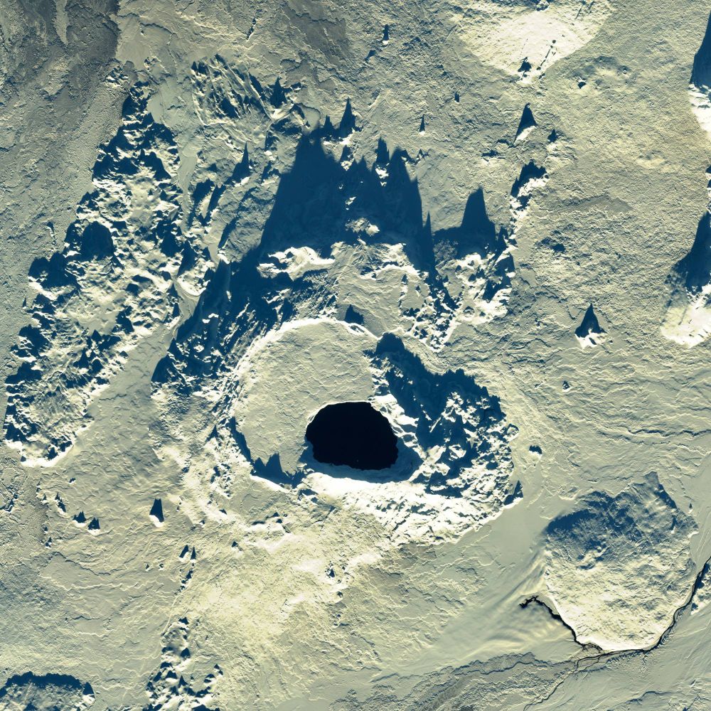
Hello Sentinel-2C 👋🛰️
Images from the recently launched @esa.int third #Sentinel2 satellite are now available. Some winter wonderland images from #Iceland acquired yesterday over the Northeastern highlands.
📸 Lake Mývatn
📸 Jöklusá á Fjöllum glacier river
📸 Askja volcanic caldera & lake
Images from the recently launched @esa.int third #Sentinel2 satellite are now available. Some winter wonderland images from #Iceland acquired yesterday over the Northeastern highlands.
📸 Lake Mývatn
📸 Jöklusá á Fjöllum glacier river
📸 Askja volcanic caldera & lake


February 27, 2025 at 11:45 AM
Hello Sentinel-2C 👋🛰️
Images from the recently launched @esa.int third #Sentinel2 satellite are now available. Some winter wonderland images from #Iceland acquired yesterday over the Northeastern highlands.
📸 Lake Mývatn
📸 Jöklusá á Fjöllum glacier river
📸 Askja volcanic caldera & lake
Images from the recently launched @esa.int third #Sentinel2 satellite are now available. Some winter wonderland images from #Iceland acquired yesterday over the Northeastern highlands.
📸 Lake Mývatn
📸 Jöklusá á Fjöllum glacier river
📸 Askja volcanic caldera & lake
Very excited to announce early public beta of our new website at The Icelandic Met Office. @maptiler.bsky.social plays a key role in delivering maps for the new site. The weather charts use their Engine + Cloud + Weather SDK with the front-end handled by our friends at #Origo -> gottvedur.is
February 8, 2025 at 3:45 PM
Very excited to announce early public beta of our new website at The Icelandic Met Office. @maptiler.bsky.social plays a key role in delivering maps for the new site. The weather charts use their Engine + Cloud + Weather SDK with the front-end handled by our friends at #Origo -> gottvedur.is
During volcanic eruptions in #Iceland the scientific community relies on The Icelandic Coast Guard for support during the first phase of events. Their fleet includes a #Bombardier Dash-8 turboprop equipped with a side-looking radar + camera systems. Today we did some training looking at volcanoes.


January 22, 2025 at 11:32 PM
During volcanic eruptions in #Iceland the scientific community relies on The Icelandic Coast Guard for support during the first phase of events. Their fleet includes a #Bombardier Dash-8 turboprop equipped with a side-looking radar + camera systems. Today we did some training looking at volcanoes.
Hi #GISchat 📢
Tomorrow I´ll be leading a #QGIS course for my Met Office coworkers, first group out of 3!
Do you have any fun geometry generators for my course? I have a few practical examples but need some funny ones to show that there are no limits (except your imagination).
Tomorrow I´ll be leading a #QGIS course for my Met Office coworkers, first group out of 3!
Do you have any fun geometry generators for my course? I have a few practical examples but need some funny ones to show that there are no limits (except your imagination).
January 15, 2025 at 7:16 PM
I should perhaps decrease my coffee consumption ☕
Here are the same images with the correct timestamp!
Here are the same images with the correct timestamp!


January 10, 2025 at 11:32 AM
I should perhaps decrease my coffee consumption ☕
Here are the same images with the correct timestamp!
Here are the same images with the correct timestamp!
More details in English on the recent #earthquake activity on the #Snæfellsnes peninsula. Data suggests magma intrusion at a considerable depth. No deformation has been observed.
en.vedur.is/about-imo/ne...
en.vedur.is/about-imo/ne...
Magmatic intrusion at considerable depth beneath
Grjótárvatn likely | News | Icelandic Meteorological office
en.vedur.is
January 9, 2025 at 4:01 PM
More details in English on the recent #earthquake activity on the #Snæfellsnes peninsula. Data suggests magma intrusion at a considerable depth. No deformation has been observed.
en.vedur.is/about-imo/ne...
en.vedur.is/about-imo/ne...
More thermal infrared images from #Landsat 😍
This image was acquired last night covering NE part of #Iceland
Partially clouded but lots of interesting things visible like the geothermal areas near Kverkfjöll and Þeistareykir.
Images with and without a hillshade blend.
#usgs #nasa #satellite
This image was acquired last night covering NE part of #Iceland
Partially clouded but lots of interesting things visible like the geothermal areas near Kverkfjöll and Þeistareykir.
Images with and without a hillshade blend.
#usgs #nasa #satellite


January 9, 2025 at 3:03 PM
More thermal infrared images from #Landsat 😍
This image was acquired last night covering NE part of #Iceland
Partially clouded but lots of interesting things visible like the geothermal areas near Kverkfjöll and Þeistareykir.
Images with and without a hillshade blend.
#usgs #nasa #satellite
This image was acquired last night covering NE part of #Iceland
Partially clouded but lots of interesting things visible like the geothermal areas near Kverkfjöll and Þeistareykir.
Images with and without a hillshade blend.
#usgs #nasa #satellite
There is no edit option on Bsky is there?
*My annual…
**SE to NW…
*My annual…
**SE to NW…
May annual earthquake map 🎆
Iceland is situated on the Mid Atlantic Ridge making it a very volcanically active. The ridge cuts the island in half from SW to the NE, slowly spreading it a part. Here are all the ~30000 earthquakes that have been verified and checked by the Icelandic Met Office staff
Iceland is situated on the Mid Atlantic Ridge making it a very volcanically active. The ridge cuts the island in half from SW to the NE, slowly spreading it a part. Here are all the ~30000 earthquakes that have been verified and checked by the Icelandic Met Office staff
January 1, 2025 at 12:29 AM
There is no edit option on Bsky is there?
*My annual…
**SE to NW…
*My annual…
**SE to NW…