


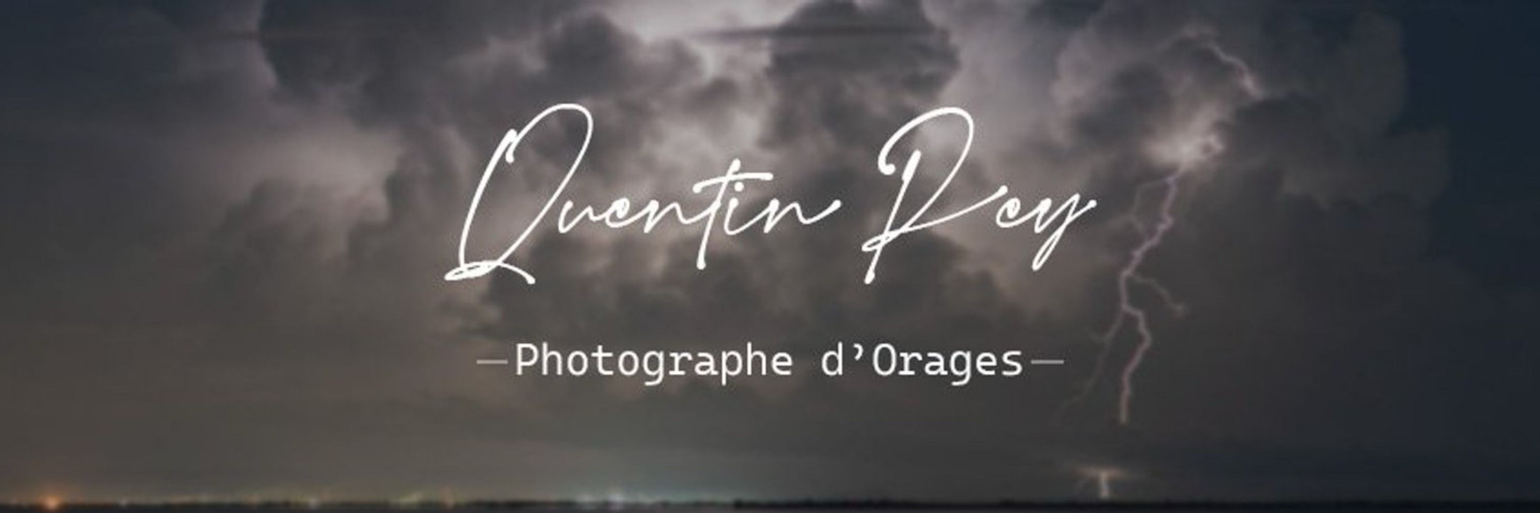

Quentin Rey Photography
@quentinrey.com
Storm Chase & Photography 📷⛈️🌪️
Severe Weather Enthusiast 🌩️
Nature, weather, climate 🌱⛅️🌍
Website : https://photo.quentinrey.com
--------
Adhérent @infoclimat.fr
Contributeur @visov1.bsky.social
Severe Weather Enthusiast 🌩️
Nature, weather, climate 🌱⛅️🌍
Website : https://photo.quentinrey.com
--------
Adhérent @infoclimat.fr
Contributeur @visov1.bsky.social
Pinned
Quentin Rey Photography
@quentinrey.com
· Jun 30

Soutenez Quentin Rey - Photographe d'Orages sur Tipeee
Tipeee est la platforme n°1 en Europe de financement participatif pour les Créateurs de contenus
fr.tipeee.com
Bonjour ! 👋
Je viens d'ouvrir une page Tipeee permettant à celle et ceux qui le veulent / peuvent de soutenir financièrement mon activité de photographe d'orage ! 📷
Toute participation sera la bienvenue ! ✨
Je vous remercie par avance ! 🙏
Orageusement votre,
Quentin
Je viens d'ouvrir une page Tipeee permettant à celle et ceux qui le veulent / peuvent de soutenir financièrement mon activité de photographe d'orage ! 📷
Toute participation sera la bienvenue ! ✨
Je vous remercie par avance ! 🙏
Orageusement votre,
Quentin
Nouvel article : Gros orage sur la région montpelliéraine dans la soirée du 3 juillet 2019 ⚡️
➡️ photo.quentinrey.com/2025/11/gros...
#Photography #Thunderstorm #wxSky #Weather
➡️ photo.quentinrey.com/2025/11/gros...
#Photography #Thunderstorm #wxSky #Weather

Gros orage sur la région montpelliéraine dans la soirée du 3 juillet 2019
Photographe amateur passionné par les orages et la météo extrême, je partage mes plus belles images d'orages et phénomènes météo.
photo.quentinrey.com
November 25, 2025 at 6:50 PM
Nouvel article : Gros orage sur la région montpelliéraine dans la soirée du 3 juillet 2019 ⚡️
➡️ photo.quentinrey.com/2025/11/gros...
#Photography #Thunderstorm #wxSky #Weather
➡️ photo.quentinrey.com/2025/11/gros...
#Photography #Thunderstorm #wxSky #Weather
Reposted by Quentin Rey Photography
#PrevisionSE Quel temps pour les prochains jours ?
🌬️ Mistral, Tramontane se lèvent à partir d'aujourd'hui et vont durer jusqu'à jeudi soir en étant localement fort notamment pour la tramontane demain #VigilanceJaune 🟡
Libeccio également assez fort aujourd'hui en Corse #VigilanceJaune 🟡
1/3
🌬️ Mistral, Tramontane se lèvent à partir d'aujourd'hui et vont durer jusqu'à jeudi soir en étant localement fort notamment pour la tramontane demain #VigilanceJaune 🟡
Libeccio également assez fort aujourd'hui en Corse #VigilanceJaune 🟡
1/3
November 25, 2025 at 6:14 AM
#PrevisionSE Quel temps pour les prochains jours ?
🌬️ Mistral, Tramontane se lèvent à partir d'aujourd'hui et vont durer jusqu'à jeudi soir en étant localement fort notamment pour la tramontane demain #VigilanceJaune 🟡
Libeccio également assez fort aujourd'hui en Corse #VigilanceJaune 🟡
1/3
🌬️ Mistral, Tramontane se lèvent à partir d'aujourd'hui et vont durer jusqu'à jeudi soir en étant localement fort notamment pour la tramontane demain #VigilanceJaune 🟡
Libeccio également assez fort aujourd'hui en Corse #VigilanceJaune 🟡
1/3
Reposted by Quentin Rey Photography

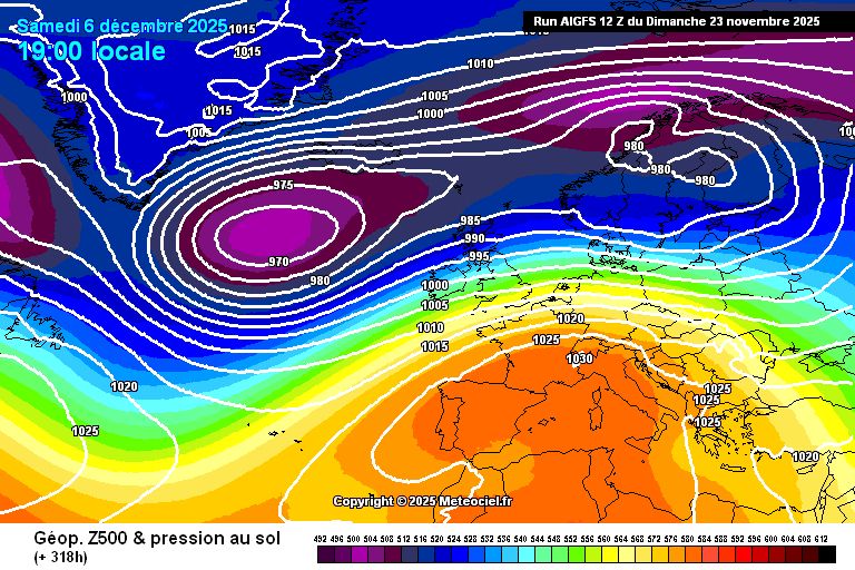
🆕 Nouveau modèle disponible sur Météociel :
AI-GFS (Global-EAGLE-Solo) expérimental 0.25° qui fait partie du projet EAGLE par la NOAA.
Ce modèle utilise le système GraphCast développé par Google réentrainé avec les données d'assimilation GDAS
➡️ meteociel.fr/r/AI-GFS
AI-GFS (Global-EAGLE-Solo) expérimental 0.25° qui fait partie du projet EAGLE par la NOAA.
Ce modèle utilise le système GraphCast développé par Google réentrainé avec les données d'assimilation GDAS
➡️ meteociel.fr/r/AI-GFS


November 23, 2025 at 7:15 PM
🆕 Nouveau modèle disponible sur Météociel :
AI-GFS (Global-EAGLE-Solo) expérimental 0.25° qui fait partie du projet EAGLE par la NOAA.
Ce modèle utilise le système GraphCast développé par Google réentrainé avec les données d'assimilation GDAS
➡️ meteociel.fr/r/AI-GFS
AI-GFS (Global-EAGLE-Solo) expérimental 0.25° qui fait partie du projet EAGLE par la NOAA.
Ce modèle utilise le système GraphCast développé par Google réentrainé avec les données d'assimilation GDAS
➡️ meteociel.fr/r/AI-GFS

Reposted by Quentin Rey Photography

Last night, a severe geomagnetic storm painted magnificent colors of the northern lights across a starry canvas over North America.

November 12, 2025 at 7:12 PM
Last night, a severe geomagnetic storm painted magnificent colors of the northern lights across a starry canvas over North America.
Orage nocturne à domicile dans la nuit du 6 septembre 2018. La composition n’est clairement pas optimale, coup de foudre relativement proche, photographié depuis le balcon ! ⚡
#thunderstorm #stormchaser #stormchasing #photography
#thunderstorm #stormchaser #stormchasing #photography


November 12, 2025 at 6:41 PM
Orage nocturne à domicile dans la nuit du 6 septembre 2018. La composition n’est clairement pas optimale, coup de foudre relativement proche, photographié depuis le balcon ! ⚡
#thunderstorm #stormchaser #stormchasing #photography
#thunderstorm #stormchaser #stormchasing #photography
Reposted by Quentin Rey Photography
Une nouvelle soirée magique a eu lieu dans la nuit du 11 au 12 Novembre avec un ciel qui s'est tenté de Rose jusqu'à l'aube 🤩. Voici quelques photos prises sur les hauteurs de Messimy (69)
@ericlagadec.bsky.social @astropierre.com @tf1info.bsky.social @bfmlyon.bsky.social @vincentledvina.bsky.social
@ericlagadec.bsky.social @astropierre.com @tf1info.bsky.social @bfmlyon.bsky.social @vincentledvina.bsky.social


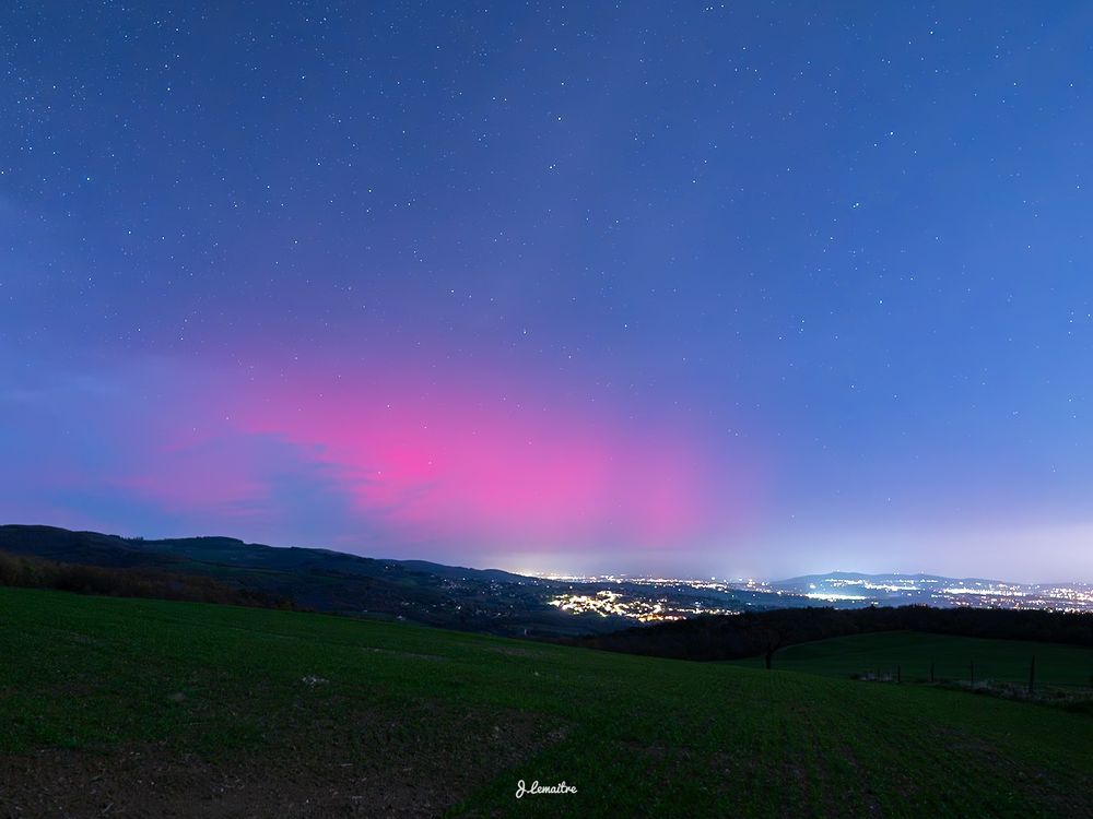

November 12, 2025 at 8:26 AM
Une nouvelle soirée magique a eu lieu dans la nuit du 11 au 12 Novembre avec un ciel qui s'est tenté de Rose jusqu'à l'aube 🤩. Voici quelques photos prises sur les hauteurs de Messimy (69)
@ericlagadec.bsky.social @astropierre.com @tf1info.bsky.social @bfmlyon.bsky.social @vincentledvina.bsky.social
@ericlagadec.bsky.social @astropierre.com @tf1info.bsky.social @bfmlyon.bsky.social @vincentledvina.bsky.social
Reposted by Quentin Rey Photography

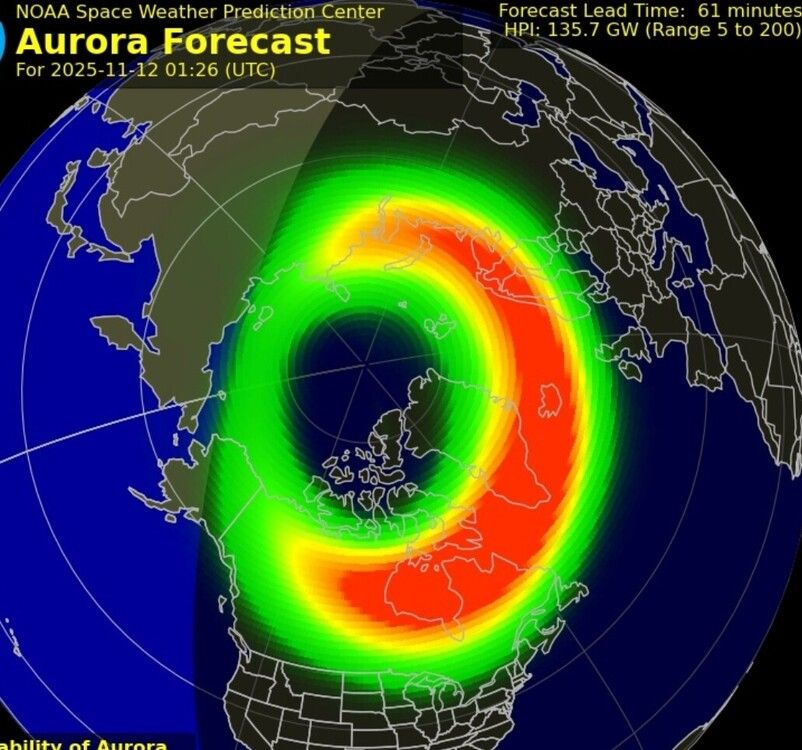
🌌 Nuit magique en ce 12 novembre ! Levez les yeux au ciel direction plein nord ! ✨
Depuis le milieu de la nuit (environs 2h du matin), les conditions sont réunies avec une tempete géomatique G4, un indice KP 8 et Bz à -60nT des aurores boréales illuminent le ciel de France métropolitaine
Depuis le milieu de la nuit (environs 2h du matin), les conditions sont réunies avec une tempete géomatique G4, un indice KP 8 et Bz à -60nT des aurores boréales illuminent le ciel de France métropolitaine


November 12, 2025 at 3:09 AM
🌌 Nuit magique en ce 12 novembre ! Levez les yeux au ciel direction plein nord ! ✨
Depuis le milieu de la nuit (environs 2h du matin), les conditions sont réunies avec une tempete géomatique G4, un indice KP 8 et Bz à -60nT des aurores boréales illuminent le ciel de France métropolitaine
Depuis le milieu de la nuit (environs 2h du matin), les conditions sont réunies avec une tempete géomatique G4, un indice KP 8 et Bz à -60nT des aurores boréales illuminent le ciel de France métropolitaine

Reposted by Quentin Rey Photography

Bonjour le Monde…😘😘

November 12, 2025 at 5:01 AM
Bonjour le Monde…😘😘
Superbes aurores cette nuit, pour celles et ceux qui avaient un ciel dégagé ! Potentiel de nouveau ce soir, il faudra suivre de près l'évolution de la situation, ça risque d'arriver un poil tôt !
Une nouvelle soirée magique a eu lieu dans la nuit du 11 au 12 Novembre avec un ciel qui s'est tenté de Rose jusqu'à l'aube 🤩. Voici quelques photos prises sur les hauteurs de Messimy (69)
@ericlagadec.bsky.social @astropierre.com @tf1info.bsky.social @bfmlyon.bsky.social @vincentledvina.bsky.social
@ericlagadec.bsky.social @astropierre.com @tf1info.bsky.social @bfmlyon.bsky.social @vincentledvina.bsky.social
November 12, 2025 at 8:39 AM
Superbes aurores cette nuit, pour celles et ceux qui avaient un ciel dégagé ! Potentiel de nouveau ce soir, il faudra suivre de près l'évolution de la situation, ça risque d'arriver un poil tôt !
Reposted by Quentin Rey Photography

A slice of what we got over the San Francisco Peaks and Mt. Elden from Buffalo Park, Flagstaff tonight around 9:45PM/0445Z. I really struggled to process this one. I am also tired. The brighter yellow-orange pillars appeared white-ish to my eye as it was happening.
#astrophotography #auroraborealis
#astrophotography #auroraborealis

November 12, 2025 at 8:30 AM
A slice of what we got over the San Francisco Peaks and Mt. Elden from Buffalo Park, Flagstaff tonight around 9:45PM/0445Z. I really struggled to process this one. I am also tired. The brighter yellow-orange pillars appeared white-ish to my eye as it was happening.
#astrophotography #auroraborealis
#astrophotography #auroraborealis
Reposted by Quentin Rey Photography
Des chances d'apercevoir des #aurores boréales à partir de ce soir et demain.
Ce soir ce serait assez tard,en début de nuit.
Pour demain,si les indices se confirment et se maintiennent,en tout début de soirée.A suivre attentivement sur les forums #infoclimat:
forums.infoclimat.fr/f/topic/1014...
Ce soir ce serait assez tard,en début de nuit.
Pour demain,si les indices se confirment et se maintiennent,en tout début de soirée.A suivre attentivement sur les forums #infoclimat:
forums.infoclimat.fr/f/topic/1014...

November 11, 2025 at 7:34 PM
Des chances d'apercevoir des #aurores boréales à partir de ce soir et demain.
Ce soir ce serait assez tard,en début de nuit.
Pour demain,si les indices se confirment et se maintiennent,en tout début de soirée.A suivre attentivement sur les forums #infoclimat:
forums.infoclimat.fr/f/topic/1014...
Ce soir ce serait assez tard,en début de nuit.
Pour demain,si les indices se confirment et se maintiennent,en tout début de soirée.A suivre attentivement sur les forums #infoclimat:
forums.infoclimat.fr/f/topic/1014...
Thundersnow with sound! ❄️🌩️

November 10, 2025 at 2:17 PM
Thundersnow with sound! ❄️🌩️


Reposted by Quentin Rey Photography
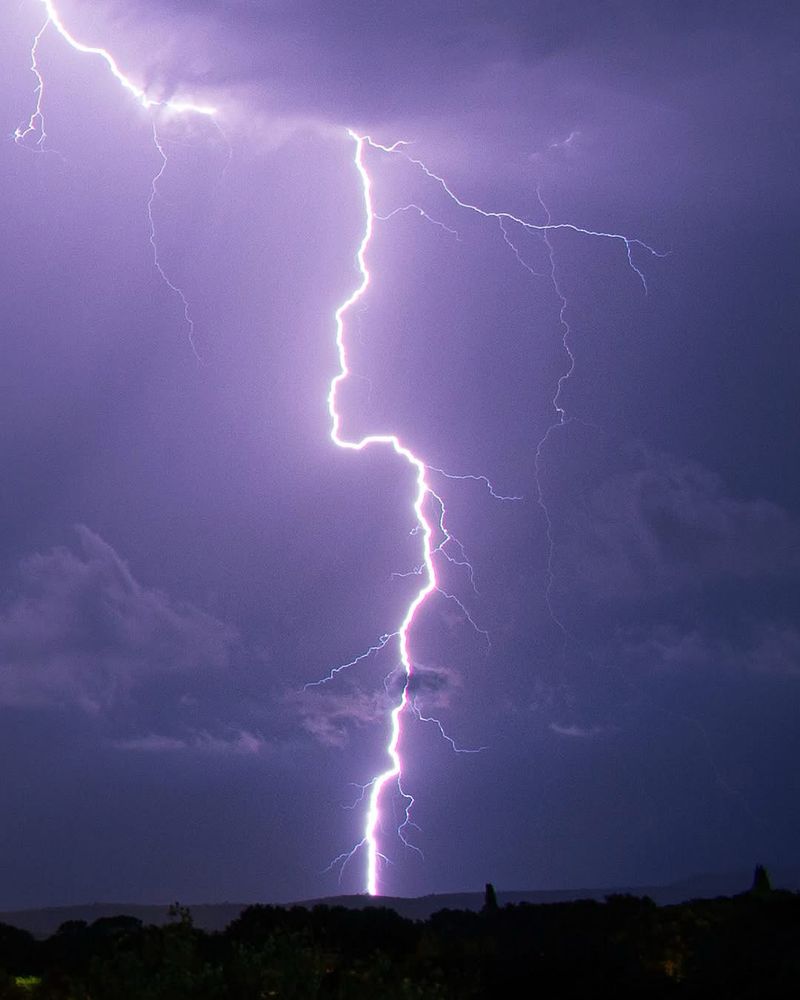
KABOOM ⚡
A close lightning strike on the night of August 13, 2018. This one really rattled my eardrums! 😬 Even though it’s a bit overexposed, you can clearly see the branching and the “frozen” raindrops. I enjoyed re-editing this photo!
What do you think?
A close lightning strike on the night of August 13, 2018. This one really rattled my eardrums! 😬 Even though it’s a bit overexposed, you can clearly see the branching and the “frozen” raindrops. I enjoyed re-editing this photo!
What do you think?


October 29, 2025 at 10:59 AM
KABOOM ⚡
A close lightning strike on the night of August 13, 2018. This one really rattled my eardrums! 😬 Even though it’s a bit overexposed, you can clearly see the branching and the “frozen” raindrops. I enjoyed re-editing this photo!
What do you think?
A close lightning strike on the night of August 13, 2018. This one really rattled my eardrums! 😬 Even though it’s a bit overexposed, you can clearly see the branching and the “frozen” raindrops. I enjoyed re-editing this photo!
What do you think?
Venez découvrir l’équipe derrière l’association et le festival Chasseurs d’Orages ! ⚡️
➡️ www.chasseurs-orages.com/2025/10/pres...
Bonne lecture !
(J’y fais une petite apparition 👀🥸)
➡️ www.chasseurs-orages.com/2025/10/pres...
Bonne lecture !
(J’y fais une petite apparition 👀🥸)

Qui est derrière l'association Chasseurs d'Orages ? | Chasseurs d'Orages
Adhérez à l’Association Chasseurs d’Orages ! Rencontre et présentation avec le bureau et les membres actifs !
www.chasseurs-orages.com
November 6, 2025 at 7:23 PM
Venez découvrir l’équipe derrière l’association et le festival Chasseurs d’Orages ! ⚡️
➡️ www.chasseurs-orages.com/2025/10/pres...
Bonne lecture !
(J’y fais une petite apparition 👀🥸)
➡️ www.chasseurs-orages.com/2025/10/pres...
Bonne lecture !
(J’y fais une petite apparition 👀🥸)
Reposted by Quentin Rey Photography
La tempête tropicale #FungWong est une sérieuse menace pour le nord des #Philippines : probable intensification en #typhon majeur d'ici ce week-end avant atterrissage sur Luzon dimanche soir. Conditions environnementales très favorables sur son trajet (SST élevées, forte divergence d'altitude, ...).


November 6, 2025 at 12:21 PM
La tempête tropicale #FungWong est une sérieuse menace pour le nord des #Philippines : probable intensification en #typhon majeur d'ici ce week-end avant atterrissage sur Luzon dimanche soir. Conditions environnementales très favorables sur son trajet (SST élevées, forte divergence d'altitude, ...).
On va voir ce que donne cette dégradation ! ⛈️
#SuiviSudEst
Une ligne orageuse traverse actuellement le #LanguedocRoussillon, elle est associée à des intensités pluvieuses soutenues, une activité électrique notable et de violentes rafales.
Elle traverse l' #Hérault puis le #Gard plus tard.
@Prefet34 @Prefet11 @Prefet30
Une ligne orageuse traverse actuellement le #LanguedocRoussillon, elle est associée à des intensités pluvieuses soutenues, une activité électrique notable et de violentes rafales.
Elle traverse l' #Hérault puis le #Gard plus tard.
@Prefet34 @Prefet11 @Prefet30
November 6, 2025 at 11:34 AM
On va voir ce que donne cette dégradation ! ⛈️
Reposted by Quentin Rey Photography


November 4, 2025 at 6:18 PM
Durant la nuit du 13 août 2018, j’ai eu le droit à de nombreux coups de foudre, tout en étant à domicile ! Ici un bel impact qui tombe à l’avant des précipitations ! ⚡
#orages #meteo #weather #thunderstorm #stormchaser #stormchasing #photographie #photo #photography
#orages #meteo #weather #thunderstorm #stormchaser #stormchasing #photographie #photo #photography


November 5, 2025 at 10:34 AM
Durant la nuit du 13 août 2018, j’ai eu le droit à de nombreux coups de foudre, tout en étant à domicile ! Ici un bel impact qui tombe à l’avant des précipitations ! ⚡
#orages #meteo #weather #thunderstorm #stormchaser #stormchasing #photographie #photo #photography
#orages #meteo #weather #thunderstorm #stormchaser #stormchasing #photographie #photo #photography
November 4, 2025 at 6:18 PM
Reposted by Quentin Rey Photography

A nearly one-week animation for Hurricane Melissa with infrared (IR) imagery on the left and its maximum wind speed (intensity) evolution on the right. The animation briefly pauses at landfall in Jamaica.
IR images extend about 600 km from the center of the storm to illustrate its shape evolution.
IR images extend about 600 km from the center of the storm to illustrate its shape evolution.
October 30, 2025 at 3:03 PM
A nearly one-week animation for Hurricane Melissa with infrared (IR) imagery on the left and its maximum wind speed (intensity) evolution on the right. The animation briefly pauses at landfall in Jamaica.
IR images extend about 600 km from the center of the storm to illustrate its shape evolution.
IR images extend about 600 km from the center of the storm to illustrate its shape evolution.
Reposted by Quentin Rey Photography

Multi-panel view of the last few days of Hurricane Melissa:
↖️ GOES-19 infrared brightness temp
↗️ GOES-19 visible satellite
↙️ Hurricane hunter planes & flight paths
↘️ Recon-derived flight level wind swath
⬇️ Estimated minimum pressure from recon dropsondes
↖️ GOES-19 infrared brightness temp
↗️ GOES-19 visible satellite
↙️ Hurricane hunter planes & flight paths
↘️ Recon-derived flight level wind swath
⬇️ Estimated minimum pressure from recon dropsondes
October 29, 2025 at 10:14 PM
Multi-panel view of the last few days of Hurricane Melissa:
↖️ GOES-19 infrared brightness temp
↗️ GOES-19 visible satellite
↙️ Hurricane hunter planes & flight paths
↘️ Recon-derived flight level wind swath
⬇️ Estimated minimum pressure from recon dropsondes
↖️ GOES-19 infrared brightness temp
↗️ GOES-19 visible satellite
↙️ Hurricane hunter planes & flight paths
↘️ Recon-derived flight level wind swath
⬇️ Estimated minimum pressure from recon dropsondes