


Phil Stooke
@philstooke.mastodon.social.ap.brid.gy
Professor Emeritus, University of Western Ontario. Space exploration and planetary cartography, historical and present. A longtime poster on […]
🌉 bridged from ⁂ https://mastodon.social/@PhilStooke, follow @ap.brid.gy to interact
🌉 bridged from ⁂ https://mastodon.social/@PhilStooke, follow @ap.brid.gy to interact
The next mission to launch to Venus was NASA's Pioneer Venus mission, with two components. Here is a NASA look back on its 4oth anniversary:
https://www.nasa.gov/centers-and-facilities/ames/40-years-ago-pioneers-encounter-venus/
The mission consisted of an […]
[Original post on mastodon.social]
https://www.nasa.gov/centers-and-facilities/ames/40-years-ago-pioneers-encounter-venus/
The mission consisted of an […]
[Original post on mastodon.social]

November 26, 2025 at 7:38 AM
The next mission to launch to Venus was NASA's Pioneer Venus mission, with two components. Here is a NASA look back on its 4oth anniversary:
https://www.nasa.gov/centers-and-facilities/ames/40-years-ago-pioneers-encounter-venus/
The mission consisted of an […]
[Original post on mastodon.social]
https://www.nasa.gov/centers-and-facilities/ames/40-years-ago-pioneers-encounter-venus/
The mission consisted of an […]
[Original post on mastodon.social]
Around the time of Veneras 9 and 10, Earth-based radar mapping was improving. This map is a composite of two radar datasets from this period, reprojected to the azimuthal projection I always use for global maps.
One paper was this:
Campbell, D.B. and Burns […]
[Original post on mastodon.social]
One paper was this:
Campbell, D.B. and Burns […]
[Original post on mastodon.social]

November 25, 2025 at 7:59 AM
Around the time of Veneras 9 and 10, Earth-based radar mapping was improving. This map is a composite of two radar datasets from this period, reprojected to the azimuthal projection I always use for global maps.
One paper was this:
Campbell, D.B. and Burns […]
[Original post on mastodon.social]
One paper was this:
Campbell, D.B. and Burns […]
[Original post on mastodon.social]
Here is a rather crudely reprojected version of the Venera 10 panorama. Once again we don't know the orientation of this map. The lander ended up on a patch of flat rocky slabs, and there seem to be similar rocky areas on each horizon, left and right. Between […]
[Original post on mastodon.social]
[Original post on mastodon.social]
November 24, 2025 at 7:46 AM
Here is a rather crudely reprojected version of the Venera 10 panorama. Once again we don't know the orientation of this map. The lander ended up on a patch of flat rocky slabs, and there seem to be similar rocky areas on each horizon, left and right. Between […]
[Original post on mastodon.social]
[Original post on mastodon.social]
Here is an old Soviet version of the Venera 10 image, a bit too contrasty so details get lost especially at the horizon. But what we see is different from Venera 9's boulders. This is a nearly flat area with platy slabs of rock interspersed with darker […]
[Original post on mastodon.social]
[Original post on mastodon.social]

November 22, 2025 at 7:40 AM
Here is an old Soviet version of the Venera 10 image, a bit too contrasty so details get lost especially at the horizon. But what we see is different from Venera 9's boulders. This is a nearly flat area with platy slabs of rock interspersed with darker […]
[Original post on mastodon.social]
[Original post on mastodon.social]
Venera 10 landed in the area shown here at two scales - at left a map spanning 500 km shows major landforms, at right, full Magellan resolution gives us details of part of the landing ellipse. We see mixed geology - the dark areas are smooth (ish) plains […]
[Original post on mastodon.social]
[Original post on mastodon.social]

November 21, 2025 at 7:24 AM
Venera 10 landed in the area shown here at two scales - at left a map spanning 500 km shows major landforms, at right, full Magellan resolution gives us details of part of the landing ellipse. We see mixed geology - the dark areas are smooth (ish) plains […]
[Original post on mastodon.social]
[Original post on mastodon.social]
Venera 10 launched 6 days after V9 (14 June '75) and landed 3 days after its sibling (25 October). This map shows the area. Like Venera 9 it was east of Beta Regio, but 1500 km further south. As with all landers so far the target was essentially unknown, only […]
[Original post on mastodon.social]
[Original post on mastodon.social]

November 20, 2025 at 7:17 AM
Venera 10 launched 6 days after V9 (14 June '75) and landed 3 days after its sibling (25 October). This map shows the area. Like Venera 9 it was east of Beta Regio, but 1500 km further south. As with all landers so far the target was essentially unknown, only […]
[Original post on mastodon.social]
[Original post on mastodon.social]
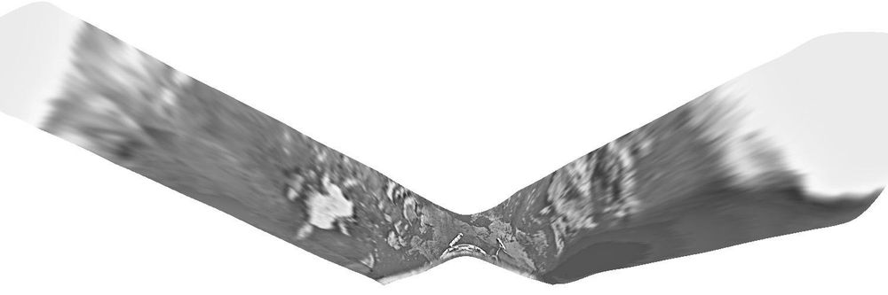
Here's that map with its crudely separated section. But what's this? Why have I rotated it? As far as I can tell there is absolutely no information about the orientation of the map, so here it is in an arbitrary orientation. I suppose a whole-sky image might […]
[Original post on mastodon.social]
[Original post on mastodon.social]

November 18, 2025 at 7:43 AM
Here's that map with its crudely separated section. But what's this? Why have I rotated it? As far as I can tell there is absolutely no information about the orientation of the map, so here it is in an arbitrary orientation. I suppose a whole-sky image might […]
[Original post on mastodon.social]
[Original post on mastodon.social]
I wanted to be able to map the Venera landing sites. We should be able to project the panoramas to a map geometry. I'm not clever enough to figure it out, but veteran space artist Don Davis published drawn maps for Veneras 9 and 10, so I had a start. He […]
[Original post on mastodon.social]
[Original post on mastodon.social]

November 17, 2025 at 8:08 AM
I wanted to be able to map the Venera landing sites. We should be able to project the panoramas to a map geometry. I'm not clever enough to figure it out, but veteran space artist Don Davis published drawn maps for Veneras 9 and 10, so I had a start. He […]
[Original post on mastodon.social]
[Original post on mastodon.social]
I want to make a map of this Venera 9 site. To start, here is a Soviet-era version of the panorama. I do want to emphasize what an incredible advance this was - the first image of the landscape of another planet, taken in October 1975, before the Viking […]
[Original post on mastodon.social]
[Original post on mastodon.social]

November 17, 2025 at 8:04 AM
I want to make a map of this Venera 9 site. To start, here is a Soviet-era version of the panorama. I do want to emphasize what an incredible advance this was - the first image of the landscape of another planet, taken in October 1975, before the Viking […]
[Original post on mastodon.social]
[Original post on mastodon.social]
If fractured cut the lava channel they are younger than the channel. It's hard to tell where the lava came from, probably one of the set of north-south fractures west of the channel. The 'chasma' is a broad rift valley. The image in this post shows the site […]
[Original post on mastodon.social]
[Original post on mastodon.social]

November 15, 2025 at 7:40 AM
If fractured cut the lava channel they are younger than the channel. It's hard to tell where the lava came from, probably one of the set of north-south fractures west of the channel. The 'chasma' is a broad rift valley. The image in this post shows the site […]
[Original post on mastodon.social]
[Original post on mastodon.social]
I missed a day so I will do two maps today. We are zooming in on the Venera 9 landing site. Yesterday it looked rough. This map shows a very fractured surface, cracks large and small all over the image. There were some gaps in radar coverage which I filled in […]
[Original post on mastodon.social]
[Original post on mastodon.social]

November 15, 2025 at 7:29 AM
I missed a day so I will do two maps today. We are zooming in on the Venera 9 landing site. Yesterday it looked rough. This map shows a very fractured surface, cracks large and small all over the image. There were some gaps in radar coverage which I filled in […]
[Original post on mastodon.social]
[Original post on mastodon.social]
Here is the Venera 9 landing site on Venus. It's on the eastern edge of Beta Regio - remember that first radar map with a big rectangle called Beta? The image here is a combination of Magellan radar images and Magellan topography - not very successful really […]
[Original post on mastodon.social]
[Original post on mastodon.social]

November 13, 2025 at 7:22 AM
Here is the Venera 9 landing site on Venus. It's on the eastern edge of Beta Regio - remember that first radar map with a big rectangle called Beta? The image here is a combination of Magellan radar images and Magellan topography - not very successful really […]
[Original post on mastodon.social]
[Original post on mastodon.social]
Let's look closer at the Venera 8 landing site. Now the mission team knew they could reach the surface it made sense to measure composition with a gamma ray instrument. Earlier probes had mostly studied the atmosphere during descent. The composition was […]
[Original post on mastodon.social]
[Original post on mastodon.social]

November 10, 2025 at 7:35 AM
Let's look closer at the Venera 8 landing site. Now the mission team knew they could reach the surface it made sense to measure composition with a gamma ray instrument. Earlier probes had mostly studied the atmosphere during descent. The composition was […]
[Original post on mastodon.social]
[Original post on mastodon.social]
Venera 8 launched on 27 March 1972 and landed on Venus on 22 July. A companion spacecraft launched 4 days later but never left Earth orbit. Venera 8 lander just after dawn at its site and measured light levels but had no camera. It ejected a radio transmitter […]
[Original post on mastodon.social]
[Original post on mastodon.social]

November 9, 2025 at 7:53 AM
Venera 8 launched on 27 March 1972 and landed on Venus on 22 July. A companion spacecraft launched 4 days later but never left Earth orbit. Venera 8 lander just after dawn at its site and measured light levels but had no camera. It ejected a radio transmitter […]
[Original post on mastodon.social]
[Original post on mastodon.social]
These images give more detail of the Venera 7 site on Venus. In the context map (left) we see an impact crater (Buck), a set of ridges collectively called Unuk Dorsa and a feature described as a 'fluctus' (flow) - in this case a lava flow. The darker plains […]
[Original post on mastodon.social]
[Original post on mastodon.social]

November 8, 2025 at 7:31 AM
These images give more detail of the Venera 7 site on Venus. In the context map (left) we see an impact crater (Buck), a set of ridges collectively called Unuk Dorsa and a feature described as a 'fluctus' (flow) - in this case a lava flow. The darker plains […]
[Original post on mastodon.social]
[Original post on mastodon.social]
Here is the Venera 7 landing region. It landed at night and did not take images. The site is close to a large circular corona - a volcanic and tectonic structure 1000 km across called Heng-o Corona. We see several 'dorsa' (ridge) structures and a 'chasma' (a […]
[Original post on mastodon.social]
[Original post on mastodon.social]

November 7, 2025 at 7:50 AM
Here is the Venera 7 landing region. It landed at night and did not take images. The site is close to a large circular corona - a volcanic and tectonic structure 1000 km across called Heng-o Corona. We see several 'dorsa' (ridge) structures and a 'chasma' (a […]
[Original post on mastodon.social]
[Original post on mastodon.social]
These are closeups, full Magellan resolution, of the Venera 5 and 6 sites: squares 100 km across inside each circle in yesterday's post. The surfaces are all lava flows and lighter patches are rougher surfaces. The thicker, wavy, east-west trending white […]
[Original post on mastodon.social]
[Original post on mastodon.social]

November 6, 2025 at 7:30 AM
These are closeups, full Magellan resolution, of the Venera 5 and 6 sites: squares 100 km across inside each circle in yesterday's post. The surfaces are all lava flows and lighter patches are rougher surfaces. The thicker, wavy, east-west trending white […]
[Original post on mastodon.social]
[Original post on mastodon.social]
These maps show the Venera 5 and 6 landing areas, close together. They were still essentially unknown landscapes. The second of two radar maps I showed earlier was the state of the art about this time and all it gives is a vague idea of radar reflectivity at […]
[Original post on mastodon.social]
[Original post on mastodon.social]

November 5, 2025 at 7:10 AM
These maps show the Venera 5 and 6 landing areas, close together. They were still essentially unknown landscapes. The second of two radar maps I showed earlier was the state of the art about this time and all it gives is a vague idea of radar reflectivity at […]
[Original post on mastodon.social]
[Original post on mastodon.social]
Here is the central part of the Venera 4 landing area seen at full Magellan resolution, about 100 m/pixel. The image spans 200 km left to right. White lines are fractures, hundreds of hem - a tectonically disrupted landscape. At right is a band of fractured […]
[Original post on mastodon.social]
[Original post on mastodon.social]

November 4, 2025 at 7:19 AM
Here is the central part of the Venera 4 landing area seen at full Magellan resolution, about 100 m/pixel. The image spans 200 km left to right. White lines are fractures, hundreds of hem - a tectonically disrupted landscape. At right is a band of fractured […]
[Original post on mastodon.social]
[Original post on mastodon.social]
This map shows the Venera 4 location, the nature of which was still unknown. Now we see it as a volcanic upland with a high mountain (Tepev Mons) and several coronae or roughly circular volcanic complexes. The day after this, Mariner 5 flew past Mars and […]
[Original post on mastodon.social]
[Original post on mastodon.social]

November 3, 2025 at 7:16 AM
This map shows the Venera 4 location, the nature of which was still unknown. Now we see it as a volcanic upland with a high mountain (Tepev Mons) and several coronae or roughly circular volcanic complexes. The day after this, Mariner 5 flew past Mars and […]
[Original post on mastodon.social]
[Original post on mastodon.social]
My last post showed where Venera 3 entered the atmosphere of Venus, with the surface mapped as we know it now. At the time this was utterly unknown. This region was not even in the area covered by those radar images. But let's look closer anyway. This map […]
[Original post on mastodon.social]
[Original post on mastodon.social]

November 2, 2025 at 6:22 AM
My last post showed where Venera 3 entered the atmosphere of Venus, with the surface mapped as we know it now. At the time this was utterly unknown. This region was not even in the area covered by those radar images. But let's look closer anyway. This map […]
[Original post on mastodon.social]
[Original post on mastodon.social]
You are trying to hit a planet for the first time. Where do you aim? For the middle of the disk as you approach it? Aim for the edge and you may miss altogether. That doesn't work for Mars where an oblique entry at the edge of the disk is needed to get a long […]
[Original post on mastodon.social]
[Original post on mastodon.social]

November 1, 2025 at 6:38 AM
You are trying to hit a planet for the first time. Where do you aim? For the middle of the disk as you approach it? Aim for the edge and you may miss altogether. That doesn't work for Mars where an oblique entry at the edge of the disk is needed to get a long […]
[Original post on mastodon.social]
[Original post on mastodon.social]
Here is the other hemisphere of Venus. Most of the planet consists of plains, some smooth and some with ridges or various small volcanic features. Tessera areas are fractured hilly areas, apparently older than most plains. A few areas called Terra (Ishtar […]
[Original post on mastodon.social]
[Original post on mastodon.social]

October 31, 2025 at 6:15 AM
Here is the other hemisphere of Venus. Most of the planet consists of plains, some smooth and some with ridges or various small volcanic features. Tessera areas are fractured hilly areas, apparently older than most plains. A few areas called Terra (Ishtar […]
[Original post on mastodon.social]
[Original post on mastodon.social]
I needed a Venus map for my Atlas of Venus Exploration. Magellan was the only source of useful data. I combined two datasets: elevation from the radar altimeter and imaging from the SAR mapper. SAR shows craters and hills up close, but at global scale it […]
[Original post on mastodon.social]
[Original post on mastodon.social]

October 30, 2025 at 6:32 AM
I needed a Venus map for my Atlas of Venus Exploration. Magellan was the only source of useful data. I combined two datasets: elevation from the radar altimeter and imaging from the SAR mapper. SAR shows craters and hills up close, but at global scale it […]
[Original post on mastodon.social]
[Original post on mastodon.social]
The surface of Venus gradually came into view more clearly. Here are two maps from 1965 (the linked paper) and 1969 (this paper:
Rogers, A.E.E. and Ingalls, R.P., 1969. Venus: Mapping the surface reflectivity by radar interferometry. Science, 165(3895), pp […]
[Original post on mastodon.social]
Rogers, A.E.E. and Ingalls, R.P., 1969. Venus: Mapping the surface reflectivity by radar interferometry. Science, 165(3895), pp […]
[Original post on mastodon.social]

October 29, 2025 at 7:01 AM
The surface of Venus gradually came into view more clearly. Here are two maps from 1965 (the linked paper) and 1969 (this paper:
Rogers, A.E.E. and Ingalls, R.P., 1969. Venus: Mapping the surface reflectivity by radar interferometry. Science, 165(3895), pp […]
[Original post on mastodon.social]
Rogers, A.E.E. and Ingalls, R.P., 1969. Venus: Mapping the surface reflectivity by radar interferometry. Science, 165(3895), pp […]
[Original post on mastodon.social]