


Phil Ferro
@pferrowxman.bsky.social
Tropical updates, to So FL weather. Chief Meteorologist at WSVN TV Miami FL. 2 x Emmy award winner.
Oh My! After a day of clouds from a weak front over South Florida... the skies clear out for a beautiful night.
December 3, 2025 at 11:05 PM
Oh My! After a day of clouds from a weak front over South Florida... the skies clear out for a beautiful night.
A look at the Thursday Forecast. Some high clouds may stick around with less humidity and little cooling. More sun for the Keys.
December 3, 2025 at 10:29 PM
A look at the Thursday Forecast. Some high clouds may stick around with less humidity and little cooling. More sun for the Keys.
A lovely end to Wednesday. A weak front made its way thru the area today with mostly cloudy skies. The clouds are now moving out and our cooling will be minimal. On the plus side, humidity levels will be low over the next 24-48 hrs. It will feel nice.

December 3, 2025 at 10:13 PM
A lovely end to Wednesday. A weak front made its way thru the area today with mostly cloudy skies. The clouds are now moving out and our cooling will be minimal. On the plus side, humidity levels will be low over the next 24-48 hrs. It will feel nice.
To get you in the Holiday Spirit!

December 3, 2025 at 9:42 PM
To get you in the Holiday Spirit!
The last Supermoon of the year, takes place Thursday. So called because it's a little closer to the earth during its orbit. Lore calls it the "Cold Moon" because it happens near the start of winter. Best viewing as it rises near the coast. Forecast calls for somel wispy clouds.

December 3, 2025 at 9:27 PM
The last Supermoon of the year, takes place Thursday. So called because it's a little closer to the earth during its orbit. Lore calls it the "Cold Moon" because it happens near the start of winter. Best viewing as it rises near the coast. Forecast calls for somel wispy clouds.
A very weak front is presently making its way across South Florida. We've seen mostly cloudy skies this Wednesday. Unfortunately the cooling if any, will be minimal.

December 3, 2025 at 9:21 PM
A very weak front is presently making its way across South Florida. We've seen mostly cloudy skies this Wednesday. Unfortunately the cooling if any, will be minimal.
Looking ahead: Warmer temps to remain across South Florida. The winter chill is set to stay up north thru the weekend.

December 3, 2025 at 9:19 PM
Looking ahead: Warmer temps to remain across South Florida. The winter chill is set to stay up north thru the weekend.
A series of weak front approach South Florida. Mild by the end of the week, but warmer with more showers by the weekend.

December 2, 2025 at 11:15 PM
A series of weak front approach South Florida. Mild by the end of the week, but warmer with more showers by the weekend.
Strong storm nearing Big Pine Key. Heavy rain w gusty winds. It's moving E at 21 mph.

December 2, 2025 at 10:37 PM
Strong storm nearing Big Pine Key. Heavy rain w gusty winds. It's moving E at 21 mph.
Some downpours are traveling NE across the Lower Keys. One or two could move onshore thru 6 pm.

December 2, 2025 at 10:05 PM
Some downpours are traveling NE across the Lower Keys. One or two could move onshore thru 6 pm.
A hot Tuesday across South Florida. While Miami Int'l & Ft.Lauderdale/Hollywood Int'l tied their records for today, they were not the only ones with very warm temps. https://Ft.La?utm_medium=social&utm_source=bluesky_

December 2, 2025 at 9:45 PM
A hot Tuesday across South Florida. While Miami Int'l & Ft.Lauderdale/Hollywood Int'l tied their records for today, they were not the only ones with very warm temps. https://Ft.La?utm_medium=social&utm_source=bluesky_
Hot for December! Both Miami & Ft. Lauderdale tied their respective records for this date. We will remain w above average temps thru next week.

December 2, 2025 at 9:34 PM
Hot for December! Both Miami & Ft. Lauderdale tied their respective records for this date. We will remain w above average temps thru next week.
The last stretch of our King Tide Season is coming up. A Full Moon , which also happens to be a Super Moon, peaks December 4th. This could make for "extra high", high tides and lead to troublesome Salt Water flooding of low lying areas near the coast.

December 1, 2025 at 10:58 PM
The last stretch of our King Tide Season is coming up. A Full Moon , which also happens to be a Super Moon, peaks December 4th. This could make for "extra high", high tides and lead to troublesome Salt Water flooding of low lying areas near the coast.
Summer-like temps are forecast for Tuesday. Miami & Ft. Lauderdale may flirt with record highs.

December 1, 2025 at 10:06 PM
Summer-like temps are forecast for Tuesday. Miami & Ft. Lauderdale may flirt with record highs.
The Keys will see lows in the mid to upper 60s on Friday.

November 28, 2025 at 3:06 AM
The Keys will see lows in the mid to upper 60s on Friday.
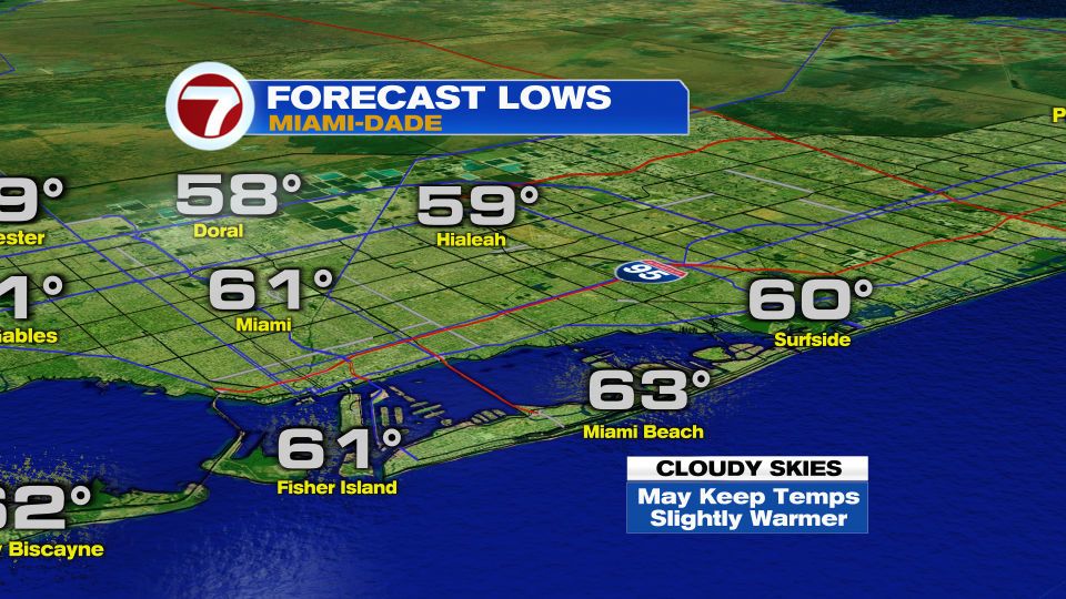
These are the forecast lows Friday for Miami-Dade County. The clouds could play a big role in the temp outcome. If they stick around too long they'll act as a blanket trapping some of the day's heating from escaping and possibly keeping the temps a bit warmer than forecast.


November 28, 2025 at 3:00 AM
These are the forecast lows Friday for Miami-Dade County. The clouds could play a big role in the temp outcome. If they stick around too long they'll act as a blanket trapping some of the day's heating from escaping and possibly keeping the temps a bit warmer than forecast.
The are the forecast lows for Broward County on Friday. Chilly by South Florida Standards.


November 28, 2025 at 2:57 AM
The are the forecast lows for Broward County on Friday. Chilly by South Florida Standards.
The 2 day South Florida Wind Forecast, suggests high pressure building after the passage of a Thanksgiving Day front.
🔴This will increase wind speeds across the region.
🔴This will mean rough boating conditions & a high Rip Current risk at the beach.
🔴This will increase wind speeds across the region.
🔴This will mean rough boating conditions & a high Rip Current risk at the beach.


November 28, 2025 at 2:32 AM
The 2 day South Florida Wind Forecast, suggests high pressure building after the passage of a Thanksgiving Day front.
🔴This will increase wind speeds across the region.
🔴This will mean rough boating conditions & a high Rip Current risk at the beach.
🔴This will increase wind speeds across the region.
🔴This will mean rough boating conditions & a high Rip Current risk at the beach.
Our In-House model performed perfectly, forecasting the Thanksgiving rain coming to an end around 8 pm. These are the 24 hour rain totals for Southeast Florida. Many other areas received between .50" to well over 1.50".

November 28, 2025 at 1:47 AM
Our In-House model performed perfectly, forecasting the Thanksgiving rain coming to an end around 8 pm. These are the 24 hour rain totals for Southeast Florida. Many other areas received between .50" to well over 1.50".
As suggested by our in-house model last night, the rain from a Thanksgiving Day front should come to an end in about an hour. We may still get an isolated shower however, thru midnight. Hope you are having a wonderful Thanksgiving!
November 27, 2025 at 11:09 PM
As suggested by our in-house model last night, the rain from a Thanksgiving Day front should come to an end in about an hour. We may still get an isolated shower however, thru midnight. Hope you are having a wonderful Thanksgiving!
Pockets of heavy rain moving ENE across Southern Miami-Dade County. One strong storm sitting South of the Hammocks with gusty winds and possible small hail. Its heading ENE at 10 - 15 mph. Should last roughly 60 minutes.


November 27, 2025 at 9:52 PM
Pockets of heavy rain moving ENE across Southern Miami-Dade County. One strong storm sitting South of the Hammocks with gusty winds and possible small hail. Its heading ENE at 10 - 15 mph. Should last roughly 60 minutes.
More rain impacting NE Broward. It's moving East at 10 - 15 mph. May last another hour. Could still see more later this evening.


November 27, 2025 at 9:50 PM
More rain impacting NE Broward. It's moving East at 10 - 15 mph. May last another hour. Could still see more later this evening.
Lingering downpours across Miami Beach are slowly moving north & have dropped a couple of inches of rain & and additional one is possible. This may lead to standing water on roadways. A Street Flood Advisory is issued thru Thursday 1 am.


November 27, 2025 at 4:09 AM
Lingering downpours across Miami Beach are slowly moving north & have dropped a couple of inches of rain & and additional one is possible. This may lead to standing water on roadways. A Street Flood Advisory is issued thru Thursday 1 am.
Air Traffic Delays have been ranging from 30 to 60 minutes all evening long. Partly due to some earlier heavy rain and additional holiday flights. If waiting on family/friends, you may want to check with their carrier.

November 27, 2025 at 3:55 AM
Air Traffic Delays have been ranging from 30 to 60 minutes all evening long. Partly due to some earlier heavy rain and additional holiday flights. If waiting on family/friends, you may want to check with their carrier.
A Chilly Forecast for parts of Northern Florida. The areas highlighted are under a Freeze Watch. This means temps near 32° are possible within the next 24 to 36 hours. Cold Turkey indeed. Hope they have a happy & warm Thanksgiving.

November 27, 2025 at 3:49 AM
A Chilly Forecast for parts of Northern Florida. The areas highlighted are under a Freeze Watch. This means temps near 32° are possible within the next 24 to 36 hours. Cold Turkey indeed. Hope they have a happy & warm Thanksgiving.