


Pete Bouchard
@petebouchard.bsky.social
Chief Meteorologist at NBC Boston. ☀️🌧️⚡️🌪️❄️💨
Snow first (starts after midnight Saturday, ends in the afternoon) then the bitter cold. Winter lumbers on…our coldest in 22 years!


February 6, 2026 at 3:39 AM
Snow first (starts after midnight Saturday, ends in the afternoon) then the bitter cold. Winter lumbers on…our coldest in 22 years!

Not a direct hit, but not a miss either. Starts as ocean effect snow along the coast Saturday night. Wraps Sunday night. Some coastal flooding possible Sunday PM high tide. Gusts could top 50mph on Cape Cod/Nantucket. (That’ll make the snow hard to measure.)


January 31, 2026 at 3:12 AM
Not a direct hit, but not a miss either. Starts as ocean effect snow along the coast Saturday night. Wraps Sunday night. Some coastal flooding possible Sunday PM high tide. Gusts could top 50mph on Cape Cod/Nantucket. (That’ll make the snow hard to measure.)
23.2” is the final tally from the storm in Boston. Took almost 4 years to nearly match the 23.6” in the blizzard of ‘23. This is Boston’s 8th highest snowfall on record for ANY month.
January 27, 2026 at 7:32 AM
23.2” is the final tally from the storm in Boston. Took almost 4 years to nearly match the 23.6” in the blizzard of ‘23. This is Boston’s 8th highest snowfall on record for ANY month.
In the thick of it now. Heavy snow thru 9-10pm. Lighter tomorrow. Some spots already up to 10”!
January 25, 2026 at 11:49 PM
In the thick of it now. Heavy snow thru 9-10pm. Lighter tomorrow. Some spots already up to 10”!
Well here it is. Starts mid AM Sunday and wraps in Monday….maybe in the PM (some uncertainty there). Most intense part is late PM Sunday until 10-11pm.

January 22, 2026 at 9:12 PM
Well here it is. Starts mid AM Sunday and wraps in Monday….maybe in the PM (some uncertainty there). Most intense part is late PM Sunday until 10-11pm.
Northern Lights possible tonight. We’ll battle the clouds, but the best viewing is toward morning. Point your phone’s camera at the faint glow in the sky to see it best.

January 19, 2026 at 10:40 PM
Northern Lights possible tonight. We’ll battle the clouds, but the best viewing is toward morning. Point your phone’s camera at the faint glow in the sky to see it best.
Moderate to heavy snow on tap from the Seacoasf of NH to Greater Worcester in next 2-3 hrs. Some of this will be mixed with sleet at times. A solid 1-2”+ possible in those locations. Inside 495 it’s mostly rain & a little sleet.

January 17, 2026 at 5:56 PM
Moderate to heavy snow on tap from the Seacoasf of NH to Greater Worcester in next 2-3 hrs. Some of this will be mixed with sleet at times. A solid 1-2”+ possible in those locations. Inside 495 it’s mostly rain & a little sleet.
Snow is moving through. Not a lot, but beware of slick spots. Exits well before dawn. Little mix or rain tomorrow night, then the thaw sets in!


January 5, 2026 at 9:36 PM
Snow is moving through. Not a lot, but beware of slick spots. Exits well before dawn. Little mix or rain tomorrow night, then the thaw sets in!
We welcomed winter at 10:03 this morning. Now for some wintry weather Tuesday. Light snow moves in by noonish. Ends late Tue. night. Some mix with rain along immediate coast.


December 22, 2025 at 2:39 AM
We welcomed winter at 10:03 this morning. Now for some wintry weather Tuesday. Light snow moves in by noonish. Ends late Tue. night. Some mix with rain along immediate coast.
High winds through the early afternoon may cause outages or damage. Big ramp DOWN for the evening, then somewhat gusty overnight. Be safe!


December 19, 2025 at 4:14 PM
High winds through the early afternoon may cause outages or damage. Big ramp DOWN for the evening, then somewhat gusty overnight. Be safe!
The first 16 days of December were the coldest in 25 years in Boston. The tide turns through Friday where we rise near 60 in the wind & rain.


December 17, 2025 at 2:51 PM
The first 16 days of December were the coldest in 25 years in Boston. The tide turns through Friday where we rise near 60 in the wind & rain.
Lenticular clouds above Mt. Washington today. Completely harmless, they form when stable air is forced to rise over a mountain range. Note the striking resemblance to “mothership” supercell thunderstorms - which can be precursors for tornadoes.


November 26, 2025 at 1:44 AM
Lenticular clouds above Mt. Washington today. Completely harmless, they form when stable air is forced to rise over a mountain range. Note the striking resemblance to “mothership” supercell thunderstorms - which can be precursors for tornadoes.
Logan Airport finally hit the magic mark. 1st 32 of the season this morning. Tough go this year. Came so close several times. Avg is Nov. 5th. Latest is Dec 6th in 2009.

November 20, 2025 at 1:48 PM
Logan Airport finally hit the magic mark. 1st 32 of the season this morning. Tough go this year. Came so close several times. Avg is Nov. 5th. Latest is Dec 6th in 2009.
1st accumulation of the season in Spencer, Mass tonight. Three days later than last year.

November 17, 2025 at 3:06 AM
1st accumulation of the season in Spencer, Mass tonight. Three days later than last year.
Reposted by Pete Bouchard

@petebouchard.bsky.social 26F and gentle snow in the Berkshires (Clarksburg 01247)

November 11, 2025 at 6:20 PM
@petebouchard.bsky.social 26F and gentle snow in the Berkshires (Clarksburg 01247)
Nothing like an early season cold blast to get your attention. Highs only near 40 Tuesday with wind chills in the 20s. 🥶 Not much better in the days ahead.


November 11, 2025 at 4:09 AM
Nothing like an early season cold blast to get your attention. Highs only near 40 Tuesday with wind chills in the 20s. 🥶 Not much better in the days ahead.
Tonight's storm over us will undergo bombogenesis by morning off Cape Breton Island, NS (pic 1). This means more wind Tue. If you're counting, that's two bombs in the Maritime provinces in less than a week...& another by Thu. Real cold pours in next week (pic 2)!


November 4, 2025 at 3:45 AM
Tonight's storm over us will undergo bombogenesis by morning off Cape Breton Island, NS (pic 1). This means more wind Tue. If you're counting, that's two bombs in the Maritime provinces in less than a week...& another by Thu. Real cold pours in next week (pic 2)!
Does this mean winter will be kind to us? Double rainbow over Needham this evening.

October 24, 2025 at 10:44 PM
Does this mean winter will be kind to us? Double rainbow over Needham this evening.
This is the heaviest it will be with this event. Lighter showers after noon, then some clearing by 3p. 🌧️
October 20, 2025 at 3:07 PM
This is the heaviest it will be with this event. Lighter showers after noon, then some clearing by 3p. 🌧️
Few unhappy customers with the rain through midday tomorrow. October air follows.


October 8, 2025 at 2:48 AM
Few unhappy customers with the rain through midday tomorrow. October air follows.
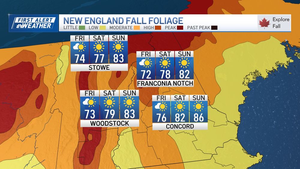
Foliage peaking in Northern New England this weekend! Toasty temps through Tuesday. Sea breezes knock us back a bit at the coast. ☀️

October 3, 2025 at 3:51 AM
Foliage peaking in Northern New England this weekend! Toasty temps through Tuesday. Sea breezes knock us back a bit at the coast. ☀️
Mild weekend ahead. Slight risk of a shower early Sunday. Steady drop in temps next week.


September 26, 2025 at 3:09 AM
Mild weekend ahead. Slight risk of a shower early Sunday. Steady drop in temps next week.
Wrestling with the guidance on how much rain will fall tomorrow. We've thrown our weight behind the European model (pic 1), while the US model isn't so sure (pic 2). European likely picking up on t-storms. (Placement may be off depending on where they form.)


September 24, 2025 at 10:22 PM
Wrestling with the guidance on how much rain will fall tomorrow. We've thrown our weight behind the European model (pic 1), while the US model isn't so sure (pic 2). European likely picking up on t-storms. (Placement may be off depending on where they form.)
I’d like to think this is our best chance at a long, soaking rain in weeks, but model guidance often overplays its hand on days-long rain (and snow) forecasts. We’ll see how it plays out.


September 22, 2025 at 3:42 AM
I’d like to think this is our best chance at a long, soaking rain in weeks, but model guidance often overplays its hand on days-long rain (and snow) forecasts. We’ll see how it plays out.