


Open Infrastructure Map
@openinframap.org
Visualising the world's infrastructure.
https://openinframap.org
[bridged from https://en.osm.town/@OpenInfraMap on the fediverse by https://fed.brid.gy/ ]
https://openinframap.org
[bridged from https://en.osm.town/@OpenInfraMap on the fediverse by https://fed.brid.gy/ ]
Designer wanted! We're looking for someone to design a logo and icons for Open Infrastructure Map. This is a paid contract.
More info & how to apply: https://github.com/openinframap/openinframap/discussions/216
#OpenStreetMap #design #webdesign
More info & how to apply: https://github.com/openinframap/openinframap/discussions/216
#OpenStreetMap #design #webdesign
April 9, 2025 at 9:40 AM
Designer wanted! We're looking for someone to design a logo and icons for Open Infrastructure Map. This is a paid contract.
More info & how to apply: https://github.com/openinframap/openinframap/discussions/216
#OpenStreetMap #design #webdesign
More info & how to apply: https://github.com/openinframap/openinframap/discussions/216
#OpenStreetMap #design #webdesign
The search box has been updated to search the power plants and substations in our database, in addition to the places search from @opencage.
(You can also paste lat/lon coordinates in the search box in order to navigate to them.)
https://openinframap.org
(You can also paste lat/lon coordinates in the search box in order to navigate to them.)
https://openinframap.org

April 8, 2025 at 3:19 PM
The search box has been updated to search the power plants and substations in our database, in addition to the places search from @opencage.
(You can also paste lat/lon coordinates in the search box in order to navigate to them.)
https://openinframap.org
(You can also paste lat/lon coordinates in the search box in order to navigate to them.)
https://openinframap.org
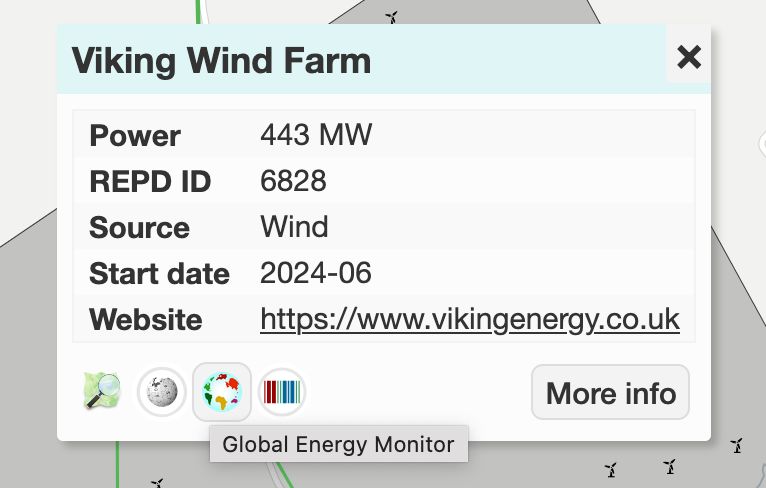
There's now a @wikidata property for Global Energy Monitor links, and Open Infrastructure Map now displays this link when available.
https://www.wikidata.org/wiki/Property:P13333
https://www.wikidata.org/wiki/Property:P13333
March 1, 2025 at 5:59 PM
There's now a @wikidata property for Global Energy Monitor links, and Open Infrastructure Map now displays this link when available.
https://www.wikidata.org/wiki/Property:P13333
https://www.wikidata.org/wiki/Property:P13333
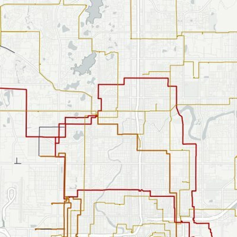
Added initial support for showing Osmose power validation issues. These are only visible at zoom level 11 and above, and clicking them is currently a bit tricky due to a Maplibre bug.
https://openinframap.org/#11.8/50.27097/1.9417/E,L,P
https://openinframap.org/#11.8/50.27097/1.9417/E,L,P

February 21, 2025 at 10:33 AM
Added initial support for showing Osmose power validation issues. These are only visible at zoom level 11 and above, and clicking them is currently a bit tricky due to a Maplibre bug.
https://openinframap.org/#11.8/50.27097/1.9417/E,L,P
https://openinframap.org/#11.8/50.27097/1.9417/E,L,P
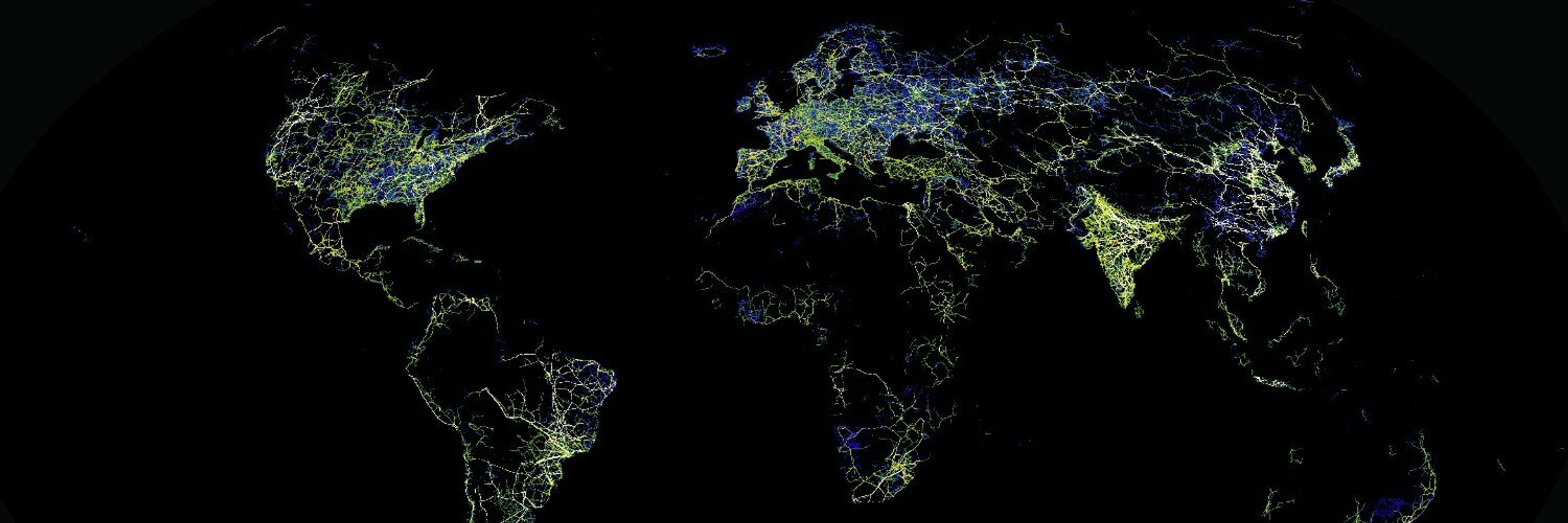
New nighttime nights layer! This shows nighttime lights data from NASA's "black marble" dataset collected by the Suomi NPP satellite. The data is from 2023.
It should be handy for identifying unmapped power infrastructure. It also looks cool.
https://openinframap.org/#2.57/40.39/5.63/N
It should be handy for identifying unmapped power infrastructure. It also looks cool.
https://openinframap.org/#2.57/40.39/5.63/N


January 10, 2025 at 12:32 AM
New nighttime nights layer! This shows nighttime lights data from NASA's "black marble" dataset collected by the Suomi NPP satellite. The data is from 2023.
It should be handy for identifying unmapped power infrastructure. It also looks cool.
https://openinframap.org/#2.57/40.39/5.63/N
It should be handy for identifying unmapped power infrastructure. It also looks cool.
https://openinframap.org/#2.57/40.39/5.63/N
The solar generation heatmap layer has been updated to finally take into account power plants which don't have generators mapped. Plant output is (roughly) estimated from area if there is none tagged.
The heatmap weightings have been re-calibrated somewhat […]
[Original post on en.osm.town]
The heatmap weightings have been re-calibrated somewhat […]
[Original post on en.osm.town]

November 29, 2024 at 7:10 PM
The solar generation heatmap layer has been updated to finally take into account power plants which don't have generators mapped. Plant output is (roughly) estimated from area if there is none tagged.
The heatmap weightings have been re-calibrated somewhat […]
[Original post on en.osm.town]
The heatmap weightings have been re-calibrated somewhat […]
[Original post on en.osm.town]
The info box has also been redesigned so it's somewhat less ugly.
Many common tag values are also now translated - we now have translations in 9 different languages, but if you'd like to help translate it into yours:
https://hosted.weblate.org/engage/open-infrastructure-map/
Many common tag values are also now translated - we now have translations in 9 different languages, but if you'd like to help translate it into yours:
https://hosted.weblate.org/engage/open-infrastructure-map/

October 28, 2024 at 9:12 PM
The info box has also been redesigned so it's somewhat less ugly.
Many common tag values are also now translated - we now have translations in 9 different languages, but if you'd like to help translate it into yours:
https://hosted.weblate.org/engage/open-infrastructure-map/
Many common tag values are also now translated - we now have translations in 9 different languages, but if you'd like to help translate it into yours:
https://hosted.weblate.org/engage/open-infrastructure-map/
A few more updates added recently: water and sewage treatment plants and reservoirs are now visible on the water layer.
https://openinframap.org/#8.5/51.3266/0.3495/L,W
#OpenStreetMap
https://openinframap.org/#8.5/51.3266/0.3495/L,W
#OpenStreetMap


October 28, 2024 at 9:08 PM
A few more updates added recently: water and sewage treatment plants and reservoirs are now visible on the water layer.
https://openinframap.org/#8.5/51.3266/0.3495/L,W
#OpenStreetMap
https://openinframap.org/#8.5/51.3266/0.3495/L,W
#OpenStreetMap
You can now follow Open Infrastructure Map on Bluesky or Mastodon (posts are bridged using Bridgy Fed).
https://bsky.app/profile/openinframap.org
https://en.osm.town/@OpenInfraMap
https://bsky.app/profile/openinframap.org
https://en.osm.town/@OpenInfraMap

October 28, 2024 at 8:29 PM
You can now follow Open Infrastructure Map on Bluesky or Mastodon (posts are bridged using Bridgy Fed).
https://bsky.app/profile/openinframap.org
https://en.osm.town/@OpenInfraMap
https://bsky.app/profile/openinframap.org
https://en.osm.town/@OpenInfraMap