


Office of the NJ State Climatologist
@njclimate.bsky.social
The Office of the New Jersey State Climatologist serves as the State focal point for activities pertaining to the climate of New Jersey.
njclimate.org
njclimate.org
8/ For more, click below!
www.njweather.org/content/all-...
Photo: Sunfish Pond along the Appalachian Trail in Worthington State Forest (Hardwick Township, Warren County) on November 6th. Photo by Dave Robinson.
www.njweather.org/content/all-...
Photo: Sunfish Pond along the Appalachian Trail in Worthington State Forest (Hardwick Township, Warren County) on November 6th. Photo by Dave Robinson.

December 10, 2025 at 12:03 AM
8/ For more, click below!
www.njweather.org/content/all-...
Photo: Sunfish Pond along the Appalachian Trail in Worthington State Forest (Hardwick Township, Warren County) on November 6th. Photo by Dave Robinson.
www.njweather.org/content/all-...
Photo: Sunfish Pond along the Appalachian Trail in Worthington State Forest (Hardwick Township, Warren County) on November 6th. Photo by Dave Robinson.
7/ Snowfall was meager, with some locations not seeing a flake and others not even a dusting. Despite some measurable totals in parts of the north, the statewide average was 0.0”. This was 0.4” below normal and ranks as lowest of the past 131 Novembers, joining 55 other years.
December 10, 2025 at 12:02 AM
7/ Snowfall was meager, with some locations not seeing a flake and others not even a dusting. Despite some measurable totals in parts of the north, the statewide average was 0.0”. This was 0.4” below normal and ranks as lowest of the past 131 Novembers, joining 55 other years.
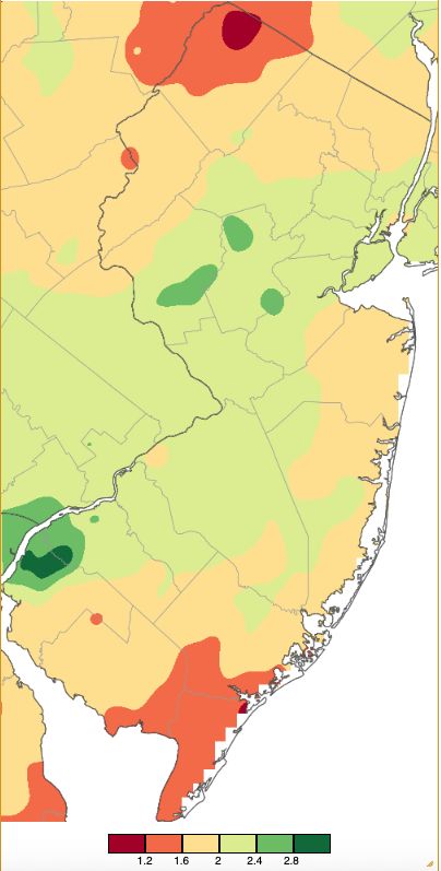
6/ The far northwest and far south were driest. Wetter totals, though still below average, were found along the Turnpike corridor and in portions of Central NJ (November monthly precipitation shown in image below).
December 10, 2025 at 12:02 AM
6/ The far northwest and far south were driest. Wetter totals, though still below average, were found along the Turnpike corridor and in portions of Central NJ (November monthly precipitation shown in image below).
5/ November precipitation, virtually all in the form of rain, averaged 1.88” across NJ.This was 1.48” below the 1991–2020 mean and ranked 23rd driest of the past 131 years.
December 10, 2025 at 12:02 AM
5/ November precipitation, virtually all in the form of rain, averaged 1.88” across NJ.This was 1.48” below the 1991–2020 mean and ranked 23rd driest of the past 131 years.
4/ The report linked below provides a discussion of November conditions, followed by a brief recap of fall precipitation and temperature statistics.
December 10, 2025 at 12:02 AM
4/ The report linked below provides a discussion of November conditions, followed by a brief recap of fall precipitation and temperature statistics.
3/ However, despite low precipitation totals, there were many dull, cloudy November days, New Jersey’s fall (fortunately) escaped any tropical storms, and just one notable early-season coastal storm occurred, albeit generating coastal flooding with associated damage.
December 10, 2025 at 12:02 AM
3/ However, despite low precipitation totals, there were many dull, cloudy November days, New Jersey’s fall (fortunately) escaped any tropical storms, and just one notable early-season coastal storm occurred, albeit generating coastal flooding with associated damage.
2/ ...this report’s title holds true for this November and fall. Certainly, there was many a gusty day this past month. Also, drought concerns failed to abate in a season where each month saw below normal statewide precipitation, making it 13 of the past 15 months with deficient precipitation.
December 10, 2025 at 12:02 AM
2/ ...this report’s title holds true for this November and fall. Certainly, there was many a gusty day this past month. Also, drought concerns failed to abate in a season where each month saw below normal statewide precipitation, making it 13 of the past 15 months with deficient precipitation.
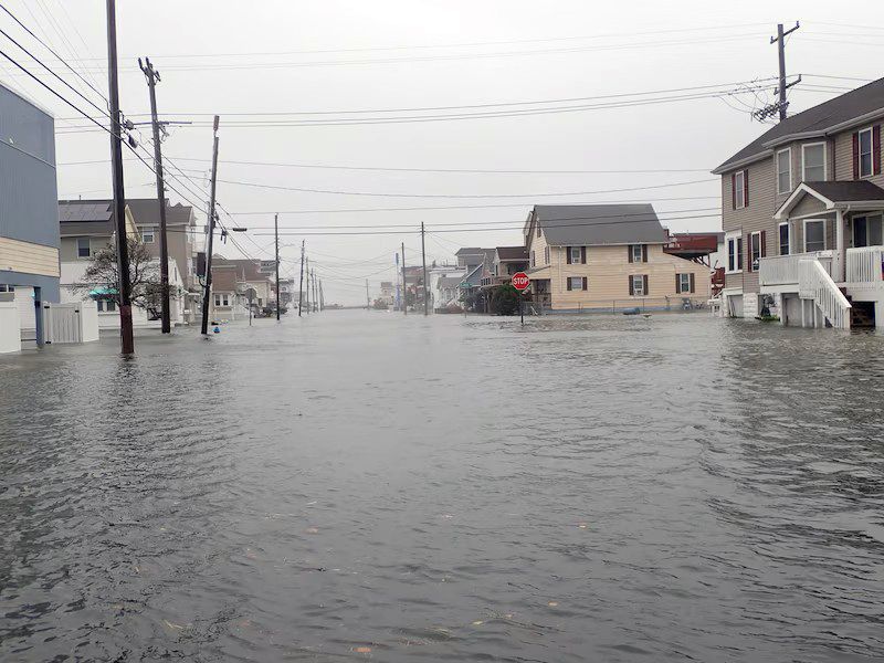
6/ Photo: Tidal flooding in North Wildwood (Cape May County) on October 12th caused by a stalled nor'easter just off the coast. Photo by Greg Graham.
November 5, 2025 at 7:14 PM
6/ Photo: Tidal flooding in North Wildwood (Cape May County) on October 12th caused by a stalled nor'easter just off the coast. Photo by Greg Graham.
5/ October precipitation averaged 3.79”, which was 0.40” below normal. Due to the skewed nature of the monthly precipitation time series, this ranked as the 57th wettest/75th driest.
For much more, click below!
https://www.njweather.org/content/transition-indeed-october-2025-recap
For much more, click below!
https://www.njweather.org/content/transition-indeed-october-2025-recap
November 5, 2025 at 7:14 PM
5/ October precipitation averaged 3.79”, which was 0.40” below normal. Due to the skewed nature of the monthly precipitation time series, this ranked as the 57th wettest/75th driest.
For much more, click below!
https://www.njweather.org/content/transition-indeed-october-2025-recap
For much more, click below!
https://www.njweather.org/content/transition-indeed-october-2025-recap
4/ The statewide average temperature of 56.2° was 0.8° above the 1991–2020 mean and ranked as the 33rd mildest of the past 131 Octobers. The average high of 66.5° was 0.7° above normal, ranking 45th mildest. The average low of 45.9° was 1.0° above normal, ranking 29th mildest.
November 5, 2025 at 7:14 PM
4/ The statewide average temperature of 56.2° was 0.8° above the 1991–2020 mean and ranked as the 33rd mildest of the past 131 Octobers. The average high of 66.5° was 0.7° above normal, ranking 45th mildest. The average low of 45.9° was 1.0° above normal, ranking 29th mildest.
3/ Ultimately, with all the ups and downs of temperature and precipitation during this transitional month, the state averaged a bit milder and drier than normal.
November 5, 2025 at 7:14 PM
3/ Ultimately, with all the ups and downs of temperature and precipitation during this transitional month, the state averaged a bit milder and drier than normal.
2/ Meanwhile, there were two notable coastal nor’easters, indicative of a transition to a cool season weather regime. Unfortunately, each resulted in notable coastal flooding and beach erosion. Yet most of NJ remains modestly to moderately dry.
November 5, 2025 at 7:14 PM
2/ Meanwhile, there were two notable coastal nor’easters, indicative of a transition to a cool season weather regime. Unfortunately, each resulted in notable coastal flooding and beach erosion. Yet most of NJ remains modestly to moderately dry.
7/ Photo: A dry Oak Ridge Reservoir along the Sussex/Morris County border on September 15th. This part of northern NJ remains in the "Moderate Drought" category at month's end. Photo courtesy of Alex Burdi.

October 7, 2025 at 8:05 PM
7/ Photo: A dry Oak Ridge Reservoir along the Sussex/Morris County border on September 15th. This part of northern NJ remains in the "Moderate Drought" category at month's end. Photo courtesy of Alex Burdi.
6/ Despite this, the state has not slid into a significant drought situation as is currently found in New England. Water resources are holding on but certainly are more vulnerable than anyone would like.
For more, click below! https://www.njweather.org/content/holding-september-2025-recap
For more, click below! https://www.njweather.org/content/holding-september-2025-recap
October 7, 2025 at 8:04 PM
6/ Despite this, the state has not slid into a significant drought situation as is currently found in New England. Water resources are holding on but certainly are more vulnerable than anyone would like.
For more, click below! https://www.njweather.org/content/holding-september-2025-recap
For more, click below! https://www.njweather.org/content/holding-september-2025-recap
5/ The month ended with most of north Jersey categorized on the US Drought Monitor as being Abnormally Dry or in Moderate Drought, and October 1st found the NJ Department of Environmental Protection (@dep.nj.gov) declaring a Drought Watch across the entire state.
October 7, 2025 at 8:04 PM
5/ The month ended with most of north Jersey categorized on the US Drought Monitor as being Abnormally Dry or in Moderate Drought, and October 1st found the NJ Department of Environmental Protection (@dep.nj.gov) declaring a Drought Watch across the entire state.
4/ Monthly precipitation came in below normal at 3.03”. This was 1.13” below normal and ranked as the 56th driest of the past 131 Septembers. It was the second consecutive month with below-normal statewide precipitation, with eleven of the past thirteen months finishing below normal.
October 7, 2025 at 8:04 PM
4/ Monthly precipitation came in below normal at 3.03”. This was 1.13” below normal and ranked as the 56th driest of the past 131 Septembers. It was the second consecutive month with below-normal statewide precipitation, with eleven of the past thirteen months finishing below normal.
3/ ...being warmer than the first. Normally, the second half averages approximately 5.0°–5.5° cooler than the first, however this year’s second half was 1.0°–1.5° milder than the first half in the north and about 2° milder in the south.
October 7, 2025 at 8:04 PM
3/ ...being warmer than the first. Normally, the second half averages approximately 5.0°–5.5° cooler than the first, however this year’s second half was 1.0°–1.5° milder than the first half in the north and about 2° milder in the south.
2/ / The average high was 78.0°, which is 0.8° above normal and ranks as the 26th warmest on record.The average low was 58.2°, which is 1.6° above normal and ranks as 12th warmest. September temperatures averaged above normal mainly due to the second half of the month...
October 7, 2025 at 8:04 PM
2/ / The average high was 78.0°, which is 0.8° above normal and ranks as the 26th warmest on record.The average low was 58.2°, which is 1.6° above normal and ranks as 12th warmest. September temperatures averaged above normal mainly due to the second half of the month...
Photo: Significant beach erosion in Beach Haven (Ocean County) following days of strong wave action caused by Hurricane Erin.
Photo by Beach Haven Mayor Colleen Lambert. (7/7)
Photo by Beach Haven Mayor Colleen Lambert. (7/7)

September 8, 2025 at 7:27 PM
Photo: Significant beach erosion in Beach Haven (Ocean County) following days of strong wave action caused by Hurricane Erin.
Photo by Beach Haven Mayor Colleen Lambert. (7/7)
Photo by Beach Haven Mayor Colleen Lambert. (7/7)
...each had 48 days where one or more Rutgers NJ Weather Network station was 90° or hotter (three of the 2024 days occurred in May).
For much more, click below!
https://www.njweather.org/content/flip-flopping-august-and-summer-2025-recaps
(6/7)
For much more, click below!
https://www.njweather.org/content/flip-flopping-august-and-summer-2025-recaps
(6/7)
September 8, 2025 at 7:27 PM
...each had 48 days where one or more Rutgers NJ Weather Network station was 90° or hotter (three of the 2024 days occurred in May).
For much more, click below!
https://www.njweather.org/content/flip-flopping-august-and-summer-2025-recaps
(6/7)
For much more, click below!
https://www.njweather.org/content/flip-flopping-august-and-summer-2025-recaps
(6/7)
Instead, the 73.6° statewide summer average was 0.5° above the 1991–2020 normal and ranked as the 16th warmest on record. Despite this ranking being 13 spots behind 2024’s summer ranking of 3rd warmest,... (5/7)
September 8, 2025 at 7:27 PM
Instead, the 73.6° statewide summer average was 0.5° above the 1991–2020 normal and ranked as the 16th warmest on record. Despite this ranking being 13 spots behind 2024’s summer ranking of 3rd warmest,... (5/7)
This summer started on the warmer-than-normal side, with June the 9th warmest dating back to 1895 and July 6th warmest. However, the cool August, at 37th coolest, put the brakes on the chance of this summer coming in at or close to warmest on record, something commonly seen in recent summers. (4/7)
September 8, 2025 at 7:27 PM
This summer started on the warmer-than-normal side, with June the 9th warmest dating back to 1895 and July 6th warmest. However, the cool August, at 37th coolest, put the brakes on the chance of this summer coming in at or close to warmest on record, something commonly seen in recent summers. (4/7)