


Nick Bassill
@nickpbassill.bsky.social
Meteorologist |
Director Of The NY State Weather Risk Communication Center @NYSWRCC |
Director of R&D, UAlbany's Center Of Excellence | Affiliated With @nysmesonet
Mostly Weather | Politics & WI Sports #gobadgers | Thoughts Mine
Director Of The NY State Weather Risk Communication Center @NYSWRCC |
Director of R&D, UAlbany's Center Of Excellence | Affiliated With @nysmesonet
Mostly Weather | Politics & WI Sports #gobadgers | Thoughts Mine
Meanwhile, in NY:

November 12, 2025 at 2:17 AM
Meanwhile, in NY:
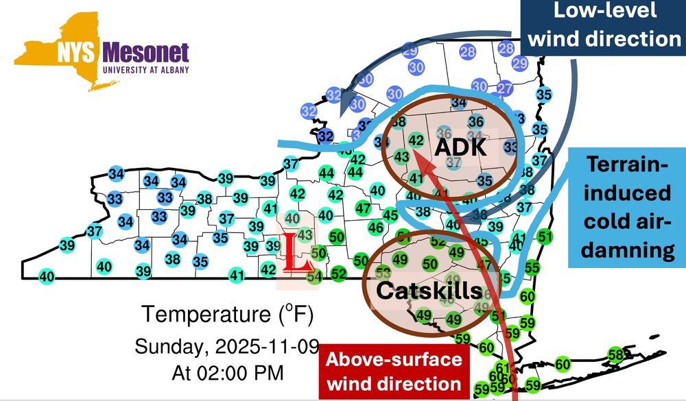
Storms like this highlight the influence terrain has on (winter) weather in NY. With low pressure across the Southern Tier, the ADK acts to channel flow down the Mohawk and induce cold air damning in northern NY. Meanwhile, higher elevations stay warmer. Classic icing set-up for northern NY. #nywx
November 9, 2025 at 7:34 PM
Storms like this highlight the influence terrain has on (winter) weather in NY. With low pressure across the Southern Tier, the ADK acts to channel flow down the Mohawk and induce cold air damning in northern NY. Meanwhile, higher elevations stay warmer. Classic icing set-up for northern NY. #nywx
I love following election results in Maine, because you get hilarious precincts like this. My favorite part is the ">95% of the vote in" estimate in a 3 vote district.

November 5, 2025 at 2:01 AM
I love following election results in Maine, because you get hilarious precincts like this. My favorite part is the ">95% of the vote in" estimate in a 3 vote district.
I want to acknowledge that the hurricane hunters have been working relentlessly and in dangerous conditions - *without pay* - to do their best to help other countries (in this case).
I wish some in our federal government had half the dedication to public good and fellow humans.
I wish some in our federal government had half the dedication to public good and fellow humans.

October 28, 2025 at 8:36 PM
I want to acknowledge that the hurricane hunters have been working relentlessly and in dangerous conditions - *without pay* - to do their best to help other countries (in this case).
I wish some in our federal government had half the dedication to public good and fellow humans.
I wish some in our federal government had half the dedication to public good and fellow humans.
Hardly the most important aspect of #Melissa, but the overshooting top about halfway through this loop on the south-central part of Jamaica is interesting (visible as a white speck that grows to a tiny circle). Likely caused by a topographical boost to already intense convection.
October 28, 2025 at 1:15 PM
Hardly the most important aspect of #Melissa, but the overshooting top about halfway through this loop on the south-central part of Jamaica is interesting (visible as a white speck that grows to a tiny circle). Likely caused by a topographical boost to already intense convection.
I know rainbow color schemes have gotten a bad rap lately for accessibility reasons, but ... they're really perfect for hurricanes like #Melissa.
One of the things that got me hooked on weather was watching these animations at a young age.
One of the things that got me hooked on weather was watching these animations at a young age.
October 28, 2025 at 2:01 AM
I know rainbow color schemes have gotten a bad rap lately for accessibility reasons, but ... they're really perfect for hurricanes like #Melissa.
One of the things that got me hooked on weather was watching these animations at a young age.
One of the things that got me hooked on weather was watching these animations at a young age.
I'm glad a big market baseball team, who also has the highest payroll, is going to the World Series yet again. Yay. Whoo. Much interest.

October 18, 2025 at 3:22 AM
I'm glad a big market baseball team, who also has the highest payroll, is going to the World Series yet again. Yay. Whoo. Much interest.
Here's the likely final map of "how many days since" the @nysmesonet.org stations here observed a given gust/direction combo.
As suggested below, several stations had combos that haven't been seen in many years. Despite "only" ~45 mph gusts, there have been 100s of downed trees & thousands outages.
As suggested below, several stations had combos that haven't been seen in many years. Despite "only" ~45 mph gusts, there have been 100s of downed trees & thousands outages.

October 13, 2025 at 9:09 PM
Here's the likely final map of "how many days since" the @nysmesonet.org stations here observed a given gust/direction combo.
As suggested below, several stations had combos that haven't been seen in many years. Despite "only" ~45 mph gusts, there have been 100s of downed trees & thousands outages.
As suggested below, several stations had combos that haven't been seen in many years. Despite "only" ~45 mph gusts, there have been 100s of downed trees & thousands outages.
Now that we're within range of the HRRR for this storm, here's a statewide map of "how many days since" a given gust/direction combo was forecast by the HRRR.
Lots of big numbers in SE NY. Peak gusts may not be noteworthy (value-wise) in most places, but the unusual NE direction may produce damage.
Lots of big numbers in SE NY. Peak gusts may not be noteworthy (value-wise) in most places, but the unusual NE direction may produce damage.

October 12, 2025 at 3:26 PM
Now that we're within range of the HRRR for this storm, here's a statewide map of "how many days since" a given gust/direction combo was forecast by the HRRR.
Lots of big numbers in SE NY. Peak gusts may not be noteworthy (value-wise) in most places, but the unusual NE direction may produce damage.
Lots of big numbers in SE NY. Peak gusts may not be noteworthy (value-wise) in most places, but the unusual NE direction may produce damage.
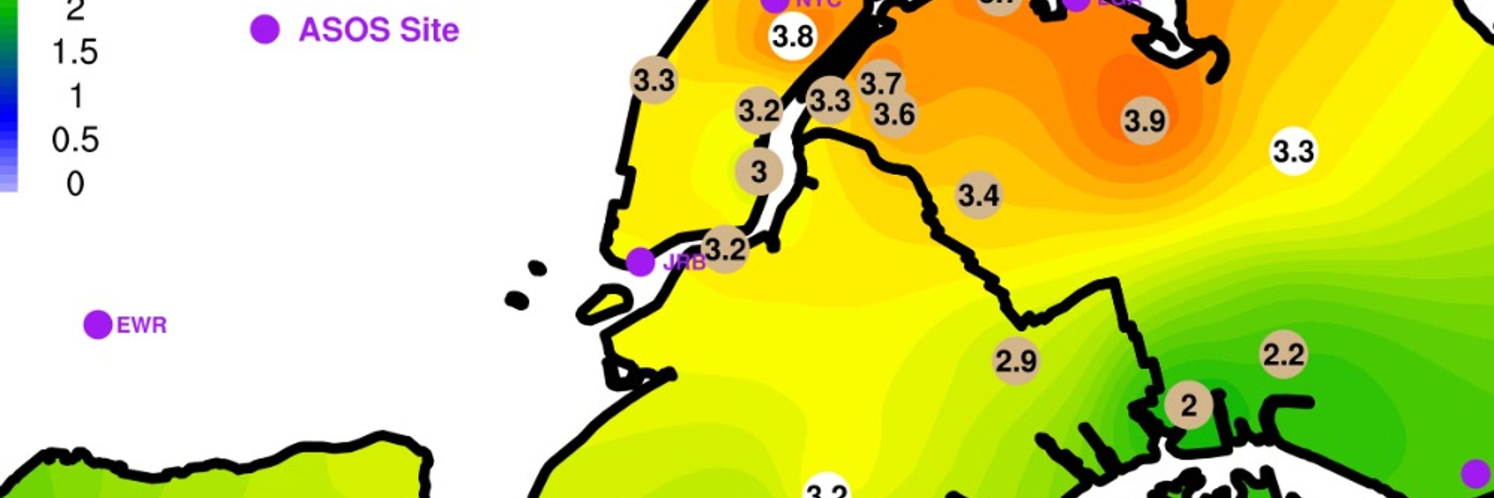
One important part of the possible coastal storm is that winds will be roughly from the NE. This is already a rare direction, and last winter featured basically zero nor'easters.
*If* ~45 mph NE gusts occur in Long Island, it could be 1000+ days since the last occurrence. Rare wind = more damage.
*If* ~45 mph NE gusts occur in Long Island, it could be 1000+ days since the last occurrence. Rare wind = more damage.


October 8, 2025 at 9:00 PM
One important part of the possible coastal storm is that winds will be roughly from the NE. This is already a rare direction, and last winter featured basically zero nor'easters.
*If* ~45 mph NE gusts occur in Long Island, it could be 1000+ days since the last occurrence. Rare wind = more damage.
*If* ~45 mph NE gusts occur in Long Island, it could be 1000+ days since the last occurrence. Rare wind = more damage.
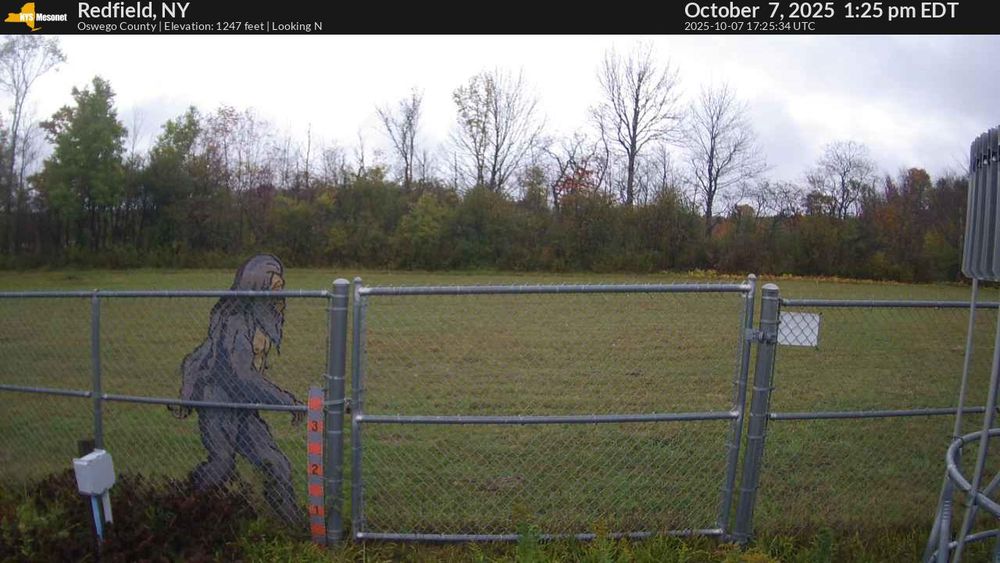
If you want evidence of bigfoot, you have to go about one hundred miles northeast, to the Redfield site. 😀
October 7, 2025 at 5:27 PM
If you want evidence of bigfoot, you have to go about one hundred miles northeast, to the Redfield site. 😀
Thanks for sharing! In our case, there are two different anemometers working in tandem: sonic + prop, which had similar readings. Since there was a clear change in both pressure and irradiance, we think it's real.
FWIW, here's a plot of raw 12 second pressure data (red) and the gust time (blue).
FWIW, here's a plot of raw 12 second pressure data (red) and the gust time (blue).

October 6, 2025 at 7:04 PM
Thanks for sharing! In our case, there are two different anemometers working in tandem: sonic + prop, which had similar readings. Since there was a clear change in both pressure and irradiance, we think it's real.
FWIW, here's a plot of raw 12 second pressure data (red) and the gust time (blue).
FWIW, here's a plot of raw 12 second pressure data (red) and the gust time (blue).
Minor mystery: the @nysmesonet.org's York site gusted to 45.4 mph today, when no other stations were even half that. There is no rain, or even many clouds in NY today.
The meteogram shows a tiny pressure blip, and a dip in irradiance. Differential heating-driven pressure wave? Dust devil?
The meteogram shows a tiny pressure blip, and a dip in irradiance. Differential heating-driven pressure wave? Dust devil?


October 6, 2025 at 5:44 PM
Minor mystery: the @nysmesonet.org's York site gusted to 45.4 mph today, when no other stations were even half that. There is no rain, or even many clouds in NY today.
The meteogram shows a tiny pressure blip, and a dip in irradiance. Differential heating-driven pressure wave? Dust devil?
The meteogram shows a tiny pressure blip, and a dip in irradiance. Differential heating-driven pressure wave? Dust devil?
I recognize that significant impacts from #Imelda are still possible without a direct landfall, but it's curious that the @accuweather.com track makes landfall while the NHC forecast keeps the storm offshore.
Your annual reminder to trust the experts at NHC & NWS.
Your annual reminder to trust the experts at NHC & NWS.


September 27, 2025 at 7:34 PM
I recognize that significant impacts from #Imelda are still possible without a direct landfall, but it's curious that the @accuweather.com track makes landfall while the NHC forecast keeps the storm offshore.
Your annual reminder to trust the experts at NHC & NWS.
Your annual reminder to trust the experts at NHC & NWS.
Fun with data:
In the last 24 hours, the NYS Mesonet's Schaghticoke station has had 3.51" (so far, most in NY). That's just .1" shy of a 24-hour record at that site.
In the 90 days *before* this period, they were the driest station in the whole state, with 4.1" (in east-central NY). #nywx
In the last 24 hours, the NYS Mesonet's Schaghticoke station has had 3.51" (so far, most in NY). That's just .1" shy of a 24-hour record at that site.
In the 90 days *before* this period, they were the driest station in the whole state, with 4.1" (in east-central NY). #nywx


September 25, 2025 at 11:36 PM
Fun with data:
In the last 24 hours, the NYS Mesonet's Schaghticoke station has had 3.51" (so far, most in NY). That's just .1" shy of a 24-hour record at that site.
In the 90 days *before* this period, they were the driest station in the whole state, with 4.1" (in east-central NY). #nywx
In the last 24 hours, the NYS Mesonet's Schaghticoke station has had 3.51" (so far, most in NY). That's just .1" shy of a 24-hour record at that site.
In the 90 days *before* this period, they were the driest station in the whole state, with 4.1" (in east-central NY). #nywx
With #Humberto and future-#Imelda in such close proximity, their future track and strength should be considered more uncertain than normal.
There's a million crazy options (some below - don't take them literally!), but of them, basically none of them give NY any rain. 😥
There's a million crazy options (some below - don't take them literally!), but of them, basically none of them give NY any rain. 😥


September 25, 2025 at 5:38 PM
With #Humberto and future-#Imelda in such close proximity, their future track and strength should be considered more uncertain than normal.
There's a million crazy options (some below - don't take them literally!), but of them, basically none of them give NY any rain. 😥
There's a million crazy options (some below - don't take them literally!), but of them, basically none of them give NY any rain. 😥
It's been very dry since June, with all but one @nysmesonet.org stations being below-average for precipitation in the last 90 days - and some almost 8" below expectations.
Column soil moisture values are near the 1st percentile for most stations, with frequent recent dry soil station records. #nywx
Column soil moisture values are near the 1st percentile for most stations, with frequent recent dry soil station records. #nywx


September 20, 2025 at 6:30 PM
It's been very dry since June, with all but one @nysmesonet.org stations being below-average for precipitation in the last 90 days - and some almost 8" below expectations.
Column soil moisture values are near the 1st percentile for most stations, with frequent recent dry soil station records. #nywx
Column soil moisture values are near the 1st percentile for most stations, with frequent recent dry soil station records. #nywx
The worst thing about this (to me) is the oxygen this takes up, at the expense of more tragic events like school shootings (today even!) and other innocent children/victims.
I thought this Yankees tweet was fake, but it isn't. The extra embarrassing thing is that Kirk clearly hated the Yankees.
I thought this Yankees tweet was fake, but it isn't. The extra embarrassing thing is that Kirk clearly hated the Yankees.

September 11, 2025 at 1:58 AM
The worst thing about this (to me) is the oxygen this takes up, at the expense of more tragic events like school shootings (today even!) and other innocent children/victims.
I thought this Yankees tweet was fake, but it isn't. The extra embarrassing thing is that Kirk clearly hated the Yankees.
I thought this Yankees tweet was fake, but it isn't. The extra embarrassing thing is that Kirk clearly hated the Yankees.

Forecast: verified! ✅
It's noon and right on cue there's a pseudo-stationary cell in east-central Albany county out ahead of the main line of storms. Meteorology is cool.
(Though I didn't use the HRRR's forecast time verbatim - historical knowledge let me know the HRRR would be late to initiation)
It's noon and right on cue there's a pseudo-stationary cell in east-central Albany county out ahead of the main line of storms. Meteorology is cool.
(Though I didn't use the HRRR's forecast time verbatim - historical knowledge let me know the HRRR would be late to initiation)
August 13, 2025 at 4:05 PM
Forecast: verified! ✅
It's noon and right on cue there's a pseudo-stationary cell in east-central Albany county out ahead of the main line of storms. Meteorology is cool.
(Though I didn't use the HRRR's forecast time verbatim - historical knowledge let me know the HRRR would be late to initiation)
It's noon and right on cue there's a pseudo-stationary cell in east-central Albany county out ahead of the main line of storms. Meteorology is cool.
(Though I didn't use the HRRR's forecast time verbatim - historical knowledge let me know the HRRR would be late to initiation)
There's a very clear signal in models like the HRRR for some Mohawk-Hudson Convergence induced thunderstorm development. In this animation of five consecutive HRRR forecasts valid at 1PM, notice how a theoretical storm is "stuck" in eastern Albany county, where winds converge.
🌩️ around noon! #nywx
🌩️ around noon! #nywx
August 13, 2025 at 1:09 PM
There's a very clear signal in models like the HRRR for some Mohawk-Hudson Convergence induced thunderstorm development. In this animation of five consecutive HRRR forecasts valid at 1PM, notice how a theoretical storm is "stuck" in eastern Albany county, where winds converge.
🌩️ around noon! #nywx
🌩️ around noon! #nywx
Beautiful day at Governors Island today, with a nice view of Manhattan.

August 9, 2025 at 5:13 PM
Beautiful day at Governors Island today, with a nice view of Manhattan.
A cybertruck spotted in its native ecosystem.

August 7, 2025 at 8:29 PM
A cybertruck spotted in its native ecosystem.
Fun with numbers:
Over the last 30 days, the Albany area is well below average in terms of precipitation: over 3" below normal (left).
But over the last 90 days (including the above), the Albany area is over 3" *above* normal. If that's all you knew, you might wonder why the grass is brown. #nywx
Over the last 30 days, the Albany area is well below average in terms of precipitation: over 3" below normal (left).
But over the last 90 days (including the above), the Albany area is over 3" *above* normal. If that's all you knew, you might wonder why the grass is brown. #nywx

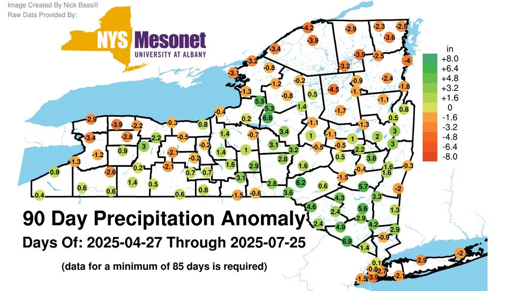
July 26, 2025 at 5:30 PM
Fun with numbers:
Over the last 30 days, the Albany area is well below average in terms of precipitation: over 3" below normal (left).
But over the last 90 days (including the above), the Albany area is over 3" *above* normal. If that's all you knew, you might wonder why the grass is brown. #nywx
Over the last 30 days, the Albany area is well below average in terms of precipitation: over 3" below normal (left).
But over the last 90 days (including the above), the Albany area is over 3" *above* normal. If that's all you knew, you might wonder why the grass is brown. #nywx
Well that's certainly not a good sign. Two high-ranking NOAA personnel were placed on leave in advance of Neil Jacobs' vote in the senate to head NOAA. These two led the investigation into sharpiegate, which involved Neil.
Read: www.cnn.com/2025/07/25/w...
Read: www.cnn.com/2025/07/25/w...

July 25, 2025 at 4:12 PM
Well that's certainly not a good sign. Two high-ranking NOAA personnel were placed on leave in advance of Neil Jacobs' vote in the senate to head NOAA. These two led the investigation into sharpiegate, which involved Neil.
Read: www.cnn.com/2025/07/25/w...
Read: www.cnn.com/2025/07/25/w...