


Nick Millea
@milleanick.bsky.social
Map Curator at the Bodleian, University of Oxford; Hon Fellow, Royal Scottish Geographical Society; Chair, Charlbury Beer Festival (2020); Cyclist ...
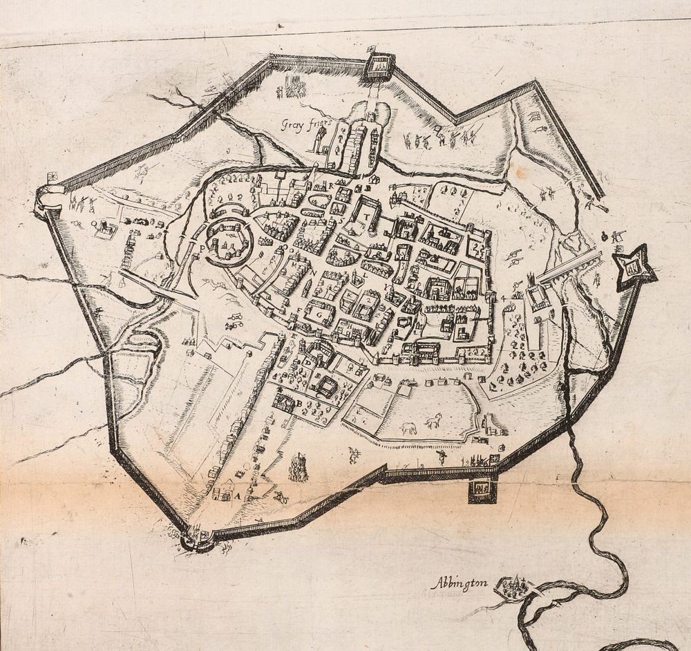
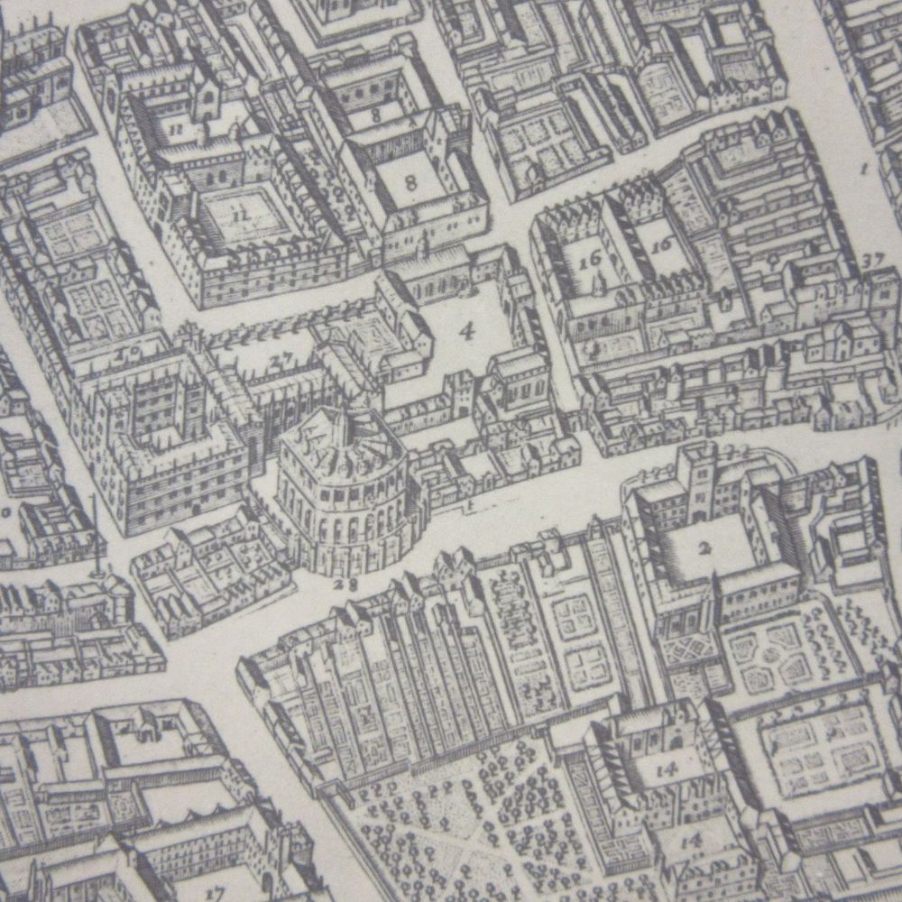
Our next @bodleian.ox.ac.uk #maps blog by @stuartackland.bsky.social features the "false" map of #Oxford from 1644. Look at this and be prepared to be confused!
blogs.bodleian.ox.ac.uk/maps/. When is north not north? And who was Anthony Wood? @bcsmaps.bsky.social @ox.ac.uk @bbcoxford.bsky.social
blogs.bodleian.ox.ac.uk/maps/. When is north not north? And who was Anthony Wood? @bcsmaps.bsky.social @ox.ac.uk @bbcoxford.bsky.social


November 26, 2025 at 12:14 PM
Our next @bodleian.ox.ac.uk #maps blog by @stuartackland.bsky.social features the "false" map of #Oxford from 1644. Look at this and be prepared to be confused!
blogs.bodleian.ox.ac.uk/maps/. When is north not north? And who was Anthony Wood? @bcsmaps.bsky.social @ox.ac.uk @bbcoxford.bsky.social
blogs.bodleian.ox.ac.uk/maps/. When is north not north? And who was Anthony Wood? @bcsmaps.bsky.social @ox.ac.uk @bbcoxford.bsky.social
Reposted by Nick Millea
RIP Jimmy Cliff, musical titan, reggae giant, who also wrote and sang this, the unofficial anthem to audax cycling. For me it has to be the rarer, R&B arrangement. @audaxuk.bsky.social www.youtube.com/watch?v=_2zs...

Jimmy Cliff - Hard Road To Travel - Federal Records RARE Soul version
YouTube video by Kingstoned - soundzz
www.youtube.com
November 24, 2025 at 2:07 PM
RIP Jimmy Cliff, musical titan, reggae giant, who also wrote and sang this, the unofficial anthem to audax cycling. For me it has to be the rarer, R&B arrangement. @audaxuk.bsky.social www.youtube.com/watch?v=_2zs...
Thursday at 16:30 (UK time) - our 1st online #TOSCA of 25/26: @drpragyaagarwal.bsky.social on 'Mapping sense of place: Travels and Maps of May Morris'. Book your place at: www.bodleian.ox.ac.uk/maps/tosca. @bodleian.ox.ac.uk @oxfordgeography.bsky.social @bcsmaps.bsky.social @imagomundi.bsky.social

November 25, 2025 at 11:24 AM
Thursday at 16:30 (UK time) - our 1st online #TOSCA of 25/26: @drpragyaagarwal.bsky.social on 'Mapping sense of place: Travels and Maps of May Morris'. Book your place at: www.bodleian.ox.ac.uk/maps/tosca. @bodleian.ox.ac.uk @oxfordgeography.bsky.social @bcsmaps.bsky.social @imagomundi.bsky.social
Reposted by Nick Millea
👀🙌 "6,652 maps associated with the Second Land Utilisation Survey of Great Britain (ca. 1958-1974)... primarily 1:10,560 National Grid sheets, were hand annotated with different colours, shadings and abbreviations to indicate land use, such as arable, settlement, industrial, grassland or woodland."

This #MapMonday we celebrate an amazing crowd-sourced project, the Second Land Utilisation Survey of Great Britain.
Directed by Professor Alice Coleman, the project involved over 3,000 volunteers, including university students and schoolchildren.
Explore the maps > maps.nls.uk/additions/#189
Directed by Professor Alice Coleman, the project involved over 3,000 volunteers, including university students and schoolchildren.
Explore the maps > maps.nls.uk/additions/#189

November 24, 2025 at 12:52 PM
👀🙌 "6,652 maps associated with the Second Land Utilisation Survey of Great Britain (ca. 1958-1974)... primarily 1:10,560 National Grid sheets, were hand annotated with different colours, shadings and abbreviations to indicate land use, such as arable, settlement, industrial, grassland or woodland."
Reposted by Nick Millea
Our article on #Mapathon 1571 is now online at the Leventhal Map & Education Center!
👉 www.leventhalmap.org/articles/map...
This publication was made possible through the Allmaps Research Fellowships.
Thanks to my co-authors at #GhentCDH and #Allmaps, and @bplmaps.bsky.social for the support.
👉 www.leventhalmap.org/articles/map...
This publication was made possible through the Allmaps Research Fellowships.
Thanks to my co-authors at #GhentCDH and #Allmaps, and @bplmaps.bsky.social for the support.

Mapathon 1571: Building Community Cartography Through Collective Georeferencing - Leventhal Map & Education Center at the Boston Public Library
How a sixteenth-century map reconnects contemporary audiences with its historical landscape
www.leventhalmap.org
November 17, 2025 at 8:17 AM
Our article on #Mapathon 1571 is now online at the Leventhal Map & Education Center!
👉 www.leventhalmap.org/articles/map...
This publication was made possible through the Allmaps Research Fellowships.
Thanks to my co-authors at #GhentCDH and #Allmaps, and @bplmaps.bsky.social for the support.
👉 www.leventhalmap.org/articles/map...
This publication was made possible through the Allmaps Research Fellowships.
Thanks to my co-authors at #GhentCDH and #Allmaps, and @bplmaps.bsky.social for the support.
Reposted by Nick Millea
We're delighted to introduce our brand new tote bag! We've partnered with the excellent folks at Teemill to create a premium quality bag made from 100% sustainable organic cotton. What better way to look stylish and promote your local heritage? Order online shop.historictownstrust.uk/product/htt-...

November 13, 2025 at 9:03 PM
We're delighted to introduce our brand new tote bag! We've partnered with the excellent folks at Teemill to create a premium quality bag made from 100% sustainable organic cotton. What better way to look stylish and promote your local heritage? Order online shop.historictownstrust.uk/product/htt-...
Reposted by Nick Millea
It's not raining inside TripelB! #belgianfrites #baconbaguette #bitterballen #frikandel #coffee #belgianbeer #belgianbeercafe #worcestershirehour #stormclaudia
November 14, 2025 at 1:16 PM
It's not raining inside TripelB! #belgianfrites #baconbaguette #bitterballen #frikandel #coffee #belgianbeer #belgianbeercafe #worcestershirehour #stormclaudia
Reposted by Nick Millea

There is still time to apply for one of our 50+ Visiting Fellowships @bodleian.ox.ac.uk for the 2026-27 academic year! A vibrant interdisciplinary research centre in the heart of one of the world’s great libraries!

VISITING FELLOWSHIPS: Applications are now open for 2026-27!
The deadline for applications is Friday 28 November 2025.
For more information on how to apply: https://www.bodleian.ox.ac.uk/csb/fellowships/bodleian-visiting-fellowships
The deadline for applications is Friday 28 November 2025.
For more information on how to apply: https://www.bodleian.ox.ac.uk/csb/fellowships/bodleian-visiting-fellowships

November 12, 2025 at 4:22 PM
There is still time to apply for one of our 50+ Visiting Fellowships @bodleian.ox.ac.uk for the 2026-27 academic year! A vibrant interdisciplinary research centre in the heart of one of the world’s great libraries!
Reposted by Nick Millea
Mapping Identities Conference 9/02/26-10/02/26 Call for Papers.
We warmly invite expressions of interest in the form of 250-word abstracts and 100-word short biographies Wednesday 17/12/25
tinyurl.com/3nnacccd
We warmly invite expressions of interest in the form of 250-word abstracts and 100-word short biographies Wednesday 17/12/25
tinyurl.com/3nnacccd

November 12, 2025 at 2:25 PM
Mapping Identities Conference 9/02/26-10/02/26 Call for Papers.
We warmly invite expressions of interest in the form of 250-word abstracts and 100-word short biographies Wednesday 17/12/25
tinyurl.com/3nnacccd
We warmly invite expressions of interest in the form of 250-word abstracts and 100-word short biographies Wednesday 17/12/25
tinyurl.com/3nnacccd
Reposted by Nick Millea

Last chance! Abstracts due tomorrow for the International Conference on the History of Cartography! #cfp #ichc2026 #skystorians #maps 🗃️
Don’t forget to submit your proposals for #ichc2026! Who wouldn’t want to talk about #maps in Prague?
Abstracts due 14 November! #skystorians 🗃️
Abstracts due 14 November! #skystorians 🗃️
ichc2026.org
November 13, 2025 at 9:09 AM
Last chance! Abstracts due tomorrow for the International Conference on the History of Cartography! #cfp #ichc2026 #skystorians #maps 🗃️
Reposted by Nick Millea
WRFM, the local radio station formerly known as Witney Radio, will be heard on digital radio (DAB) in West Oxfordshire after winning a licence from Ofcom. The station already has FM licences in West Oxfordshire and DAB in Oxford city.

November 12, 2025 at 10:08 AM
WRFM, the local radio station formerly known as Witney Radio, will be heard on digital radio (DAB) in West Oxfordshire after winning a licence from Ofcom. The station already has FM licences in West Oxfordshire and DAB in Oxford city.
Reposted by Nick Millea
Come along to see Livingmapper @mikeduggan4.bsky.social chair a panel discussion on the question of 'who controls the map' at @britishlibrary.bsky.social events.bl.uk/events/onlin...

The Lie of the Land: Who Controls the Map? | British Library
Technologist Ed Parsons, Dr Ollie Ballinger and Dr Pragya Agarwal join cultural geographer Mike Duggan in this panel conversation to explore how maps and c
events.bl.uk
November 7, 2025 at 10:22 AM
Come along to see Livingmapper @mikeduggan4.bsky.social chair a panel discussion on the question of 'who controls the map' at @britishlibrary.bsky.social events.bl.uk/events/onlin...
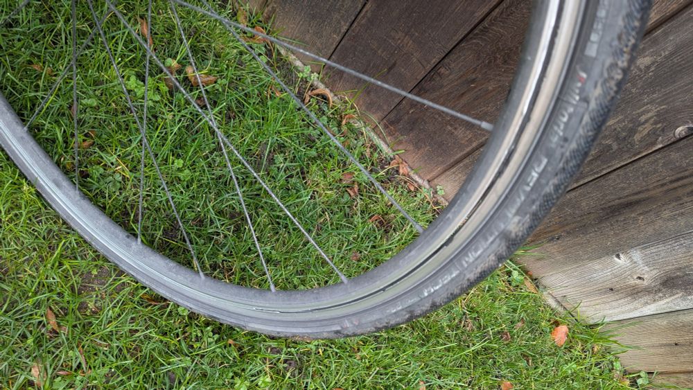
A different sort of commute today ... The rim split on my front wheel, a 4-mile walk from the nearest train station. Thanks to @gwr.com for getting me to work and @blenheimpalace.bsky.social for a scenic walk.
November 6, 2025 at 1:35 PM
A different sort of commute today ... The rim split on my front wheel, a 4-mile walk from the nearest train station. Thanks to @gwr.com for getting me to work and @blenheimpalace.bsky.social for a scenic walk.
Reposted by Nick Millea
Our YouTube channel has beefed up for the winter! You can now watch lots of brilliant talks about mapmaking and the history of Britain's towns and cities. Please subscribe here: www.youtube.com/@hist_towns

Historic Towns Trust
An educational charity working to map the urban histories of Great Britain.
www.youtube.com
November 4, 2025 at 6:56 PM
Our YouTube channel has beefed up for the winter! You can now watch lots of brilliant talks about mapmaking and the history of Britain's towns and cities. Please subscribe here: www.youtube.com/@hist_towns
Reposted by Nick Millea
📣📣 PRIZE 📣📣
The International Society for the History of the Map (ISHMap) is pleased to invite nominations and self-nominations for its Prize for Projects in Map History.
Details: ishmap.com/prize-for-pr...
@kparkerhistorian.bsky.social
The International Society for the History of the Map (ISHMap) is pleased to invite nominations and self-nominations for its Prize for Projects in Map History.
Details: ishmap.com/prize-for-pr...
@kparkerhistorian.bsky.social

Prize for Projects in Map History 2026
The International Society for the History of the Map (ISHMap) is pleased to invite nominations and self-nominations for its Prize for Projects in Map History. The ISHMap Prize in for Pr…
ishmap.com
November 4, 2025 at 3:14 PM
📣📣 PRIZE 📣📣
The International Society for the History of the Map (ISHMap) is pleased to invite nominations and self-nominations for its Prize for Projects in Map History.
Details: ishmap.com/prize-for-pr...
@kparkerhistorian.bsky.social
The International Society for the History of the Map (ISHMap) is pleased to invite nominations and self-nominations for its Prize for Projects in Map History.
Details: ishmap.com/prize-for-pr...
@kparkerhistorian.bsky.social
Reposted by Nick Millea
Don’t forget to submit your proposals for #ichc2026! Who wouldn’t want to talk about #maps in Prague?
Abstracts due 14 November! #skystorians 🗃️
Abstracts due 14 November! #skystorians 🗃️
ichc2026.org
November 3, 2025 at 10:03 PM
Don’t forget to submit your proposals for #ichc2026! Who wouldn’t want to talk about #maps in Prague?
Abstracts due 14 November! #skystorians 🗃️
Abstracts due 14 November! #skystorians 🗃️
Reposted by Nick Millea
We finished the day with stories and insights from Felicity Aston and Phoebe Smith, two contemporary explorers who use and think about #maps a lot. What a great day!
Thanks to all attended @rgsibg.bsky.social and online!
Thanks to all attended @rgsibg.bsky.social and online!
October 31, 2025 at 8:08 AM
We finished the day with stories and insights from Felicity Aston and Phoebe Smith, two contemporary explorers who use and think about #maps a lot. What a great day!
Thanks to all attended @rgsibg.bsky.social and online!
Thanks to all attended @rgsibg.bsky.social and online!
Reposted by Nick Millea
The Challenging Maps & Exploration symposium is in full swing!
We started with maps & empire & are now discussing Indigeneity, archives, & mapping.
Michael Bravo just asked, “How do we listen to maps?” Just one of many provocative questions that drive today’s conversations. #maps #skystorians 🗃️
We started with maps & empire & are now discussing Indigeneity, archives, & mapping.
Michael Bravo just asked, “How do we listen to maps?” Just one of many provocative questions that drive today’s conversations. #maps #skystorians 🗃️
October 30, 2025 at 11:55 AM
The Challenging Maps & Exploration symposium is in full swing!
We started with maps & empire & are now discussing Indigeneity, archives, & mapping.
Michael Bravo just asked, “How do we listen to maps?” Just one of many provocative questions that drive today’s conversations. #maps #skystorians 🗃️
We started with maps & empire & are now discussing Indigeneity, archives, & mapping.
Michael Bravo just asked, “How do we listen to maps?” Just one of many provocative questions that drive today’s conversations. #maps #skystorians 🗃️
Reposted by Nick Millea
Lots going on in this picture from a Dutch sea atlas, 1676. Figures point cross-staffs to a sea-torch, symbolizing navigation, others measure maps and globes with compasses. A sailor holds a sounding weight to measure depths and a navigator a marine astrolabe to measure latitude @bodleian.ox.ac.uk


October 30, 2025 at 2:54 PM
Lots going on in this picture from a Dutch sea atlas, 1676. Figures point cross-staffs to a sea-torch, symbolizing navigation, others measure maps and globes with compasses. A sailor holds a sounding weight to measure depths and a navigator a marine astrolabe to measure latitude @bodleian.ox.ac.uk
Reposted by Nick Millea

Secret Maps opens today! 🤫 🗺️
From medieval manuscripts to Cold War espionage, our new exhibition explores how maps have hidden as much as they revealed for over 600 years.
Book now: bit.ly/BLSecretMaps
From medieval manuscripts to Cold War espionage, our new exhibition explores how maps have hidden as much as they revealed for over 600 years.
Book now: bit.ly/BLSecretMaps
October 24, 2025 at 12:26 PM
Secret Maps opens today! 🤫 🗺️
From medieval manuscripts to Cold War espionage, our new exhibition explores how maps have hidden as much as they revealed for over 600 years.
Book now: bit.ly/BLSecretMaps
From medieval manuscripts to Cold War espionage, our new exhibition explores how maps have hidden as much as they revealed for over 600 years.
Book now: bit.ly/BLSecretMaps
Our next season for The Oxford Seminars in Cartography ... #TOSCA @bodleian.ox.ac.uk @oxfordgeography.bsky.social Register at: visit.bodleian.ox.ac.uk/tosca
More info at: www.bodleian.ox.ac.uk/maps/tosca @bcsmaps.bsky.social @ordnancesurvey.bsky.social
1st speaker is @drpragyaagarwal.bsky.social
More info at: www.bodleian.ox.ac.uk/maps/tosca @bcsmaps.bsky.social @ordnancesurvey.bsky.social
1st speaker is @drpragyaagarwal.bsky.social

October 24, 2025 at 2:02 PM
Our next season for The Oxford Seminars in Cartography ... #TOSCA @bodleian.ox.ac.uk @oxfordgeography.bsky.social Register at: visit.bodleian.ox.ac.uk/tosca
More info at: www.bodleian.ox.ac.uk/maps/tosca @bcsmaps.bsky.social @ordnancesurvey.bsky.social
1st speaker is @drpragyaagarwal.bsky.social
More info at: www.bodleian.ox.ac.uk/maps/tosca @bcsmaps.bsky.social @ordnancesurvey.bsky.social
1st speaker is @drpragyaagarwal.bsky.social
Reposted by Nick Millea
Cronos, Greek god of death and time (hence the scythe and hourglass) and Hercules (in one of his labours, capturing the multi-headed dog Cerberus) either side of an armillary sphere in a 1663 Blaeu atlas of Asia. On the next page Hercules opens a door onto the continent @bodleian.ox.ac.uk


October 24, 2025 at 8:27 AM
Cronos, Greek god of death and time (hence the scythe and hourglass) and Hercules (in one of his labours, capturing the multi-headed dog Cerberus) either side of an armillary sphere in a 1663 Blaeu atlas of Asia. On the next page Hercules opens a door onto the continent @bodleian.ox.ac.uk
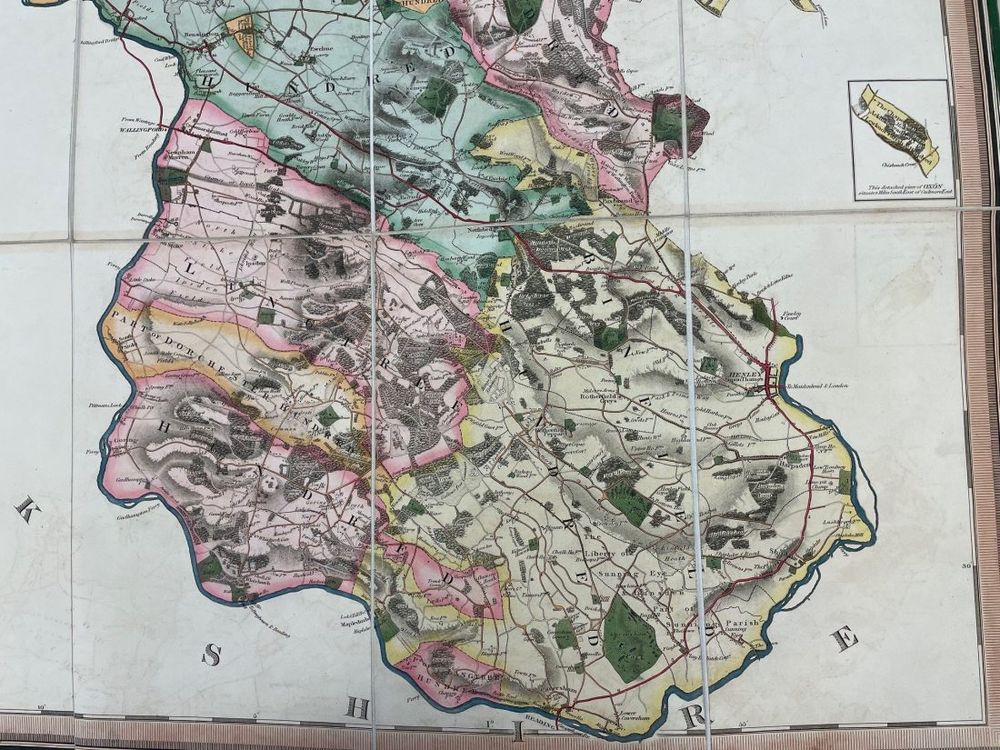
Definitely "nice to look at". Another @bodleian.ox.ac.uk #Maps blog by @debbietheduck.bsky.social looks at a recently-discovered letter accompanying Bryant's stunning 1824 map of #Oxfordshire. A great endorsement of @ordnancesurvey.bsky.social mapping too. Go to: blogs.bodleian.ox.ac.uk/maps/


October 20, 2025 at 11:29 AM
Definitely "nice to look at". Another @bodleian.ox.ac.uk #Maps blog by @debbietheduck.bsky.social looks at a recently-discovered letter accompanying Bryant's stunning 1824 map of #Oxfordshire. A great endorsement of @ordnancesurvey.bsky.social mapping too. Go to: blogs.bodleian.ox.ac.uk/maps/
Reposted by Nick Millea

Café ride to test the upcoming version of the cycle.travel app ☕️

October 15, 2025 at 12:37 PM
Café ride to test the upcoming version of the cycle.travel app ☕️
Reposted by Nick Millea
'Close's fisherman's chart', c1922, has some beautifully poetic descriptions of fishing grounds and trawling sites, along with a timeline of U-Boats captured or destroyed in the channel during the First World War, including this piece about the activities of Skipper Tom Phillips @bodleian.ox.ac.uk


October 16, 2025 at 10:11 AM
'Close's fisherman's chart', c1922, has some beautifully poetic descriptions of fishing grounds and trawling sites, along with a timeline of U-Boats captured or destroyed in the channel during the First World War, including this piece about the activities of Skipper Tom Phillips @bodleian.ox.ac.uk