


Mika Rantanen
@mikarantane.bsky.social
Researcher in Finnish Meteorological Institute. Climate change, extreme weather, and attribution of extreme events. PhD in meteorology in University of Helsinki.
Extremely cold conditions have prevailed under surface inversion in Lapland now for several days. Some stations have not risen above -25 °C even in the daytime, which is exceptional for the time of the year.
For example, Kittilä Lompolonvuoma *highest* today is -27.1 °C.
For example, Kittilä Lompolonvuoma *highest* today is -27.1 °C.

November 21, 2025 at 10:29 AM
Extremely cold conditions have prevailed under surface inversion in Lapland now for several days. Some stations have not risen above -25 °C even in the daytime, which is exceptional for the time of the year.
For example, Kittilä Lompolonvuoma *highest* today is -27.1 °C.
For example, Kittilä Lompolonvuoma *highest* today is -27.1 °C.
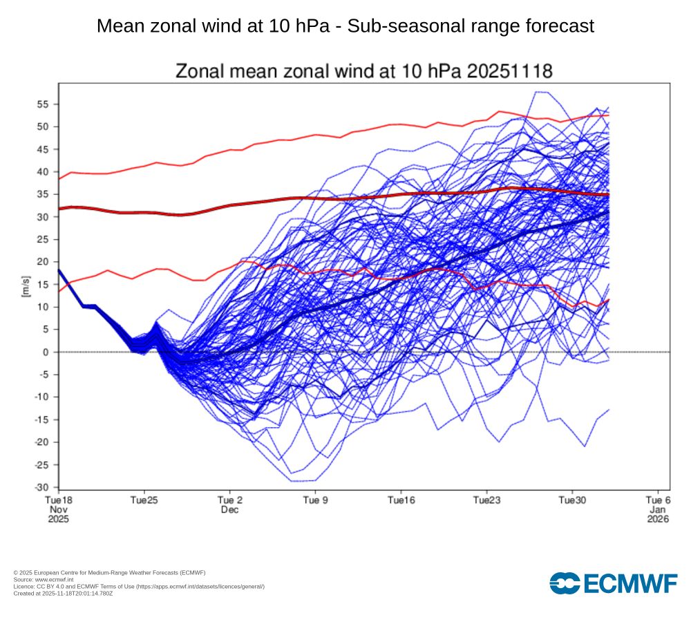
Now, a majority of the 101 ensemble members in the ECMWF subseasonal forecast are indicating a major sudden stratospheric warming (SSW) event next week.
November SSWs are extremely rare: over the last 67 years, there is only one known event (Nov 1968).
November SSWs are extremely rare: over the last 67 years, there is only one known event (Nov 1968).
November 19, 2025 at 8:26 AM
Now, a majority of the 101 ensemble members in the ECMWF subseasonal forecast are indicating a major sudden stratospheric warming (SSW) event next week.
November SSWs are extremely rare: over the last 67 years, there is only one known event (Nov 1968).
November SSWs are extremely rare: over the last 67 years, there is only one known event (Nov 1968).
During the event, the 850 hPa temperatures measured by the Tallinn radiosonde was -4.3 °C.
What if the airmass had been only a few degrees colder? Would it have been all snow?
This is a good example of these “what if” scenarios and illustrates the non-linear impacts of climate change.
What if the airmass had been only a few degrees colder? Would it have been all snow?
This is a good example of these “what if” scenarios and illustrates the non-linear impacts of climate change.

November 17, 2025 at 8:24 AM
During the event, the 850 hPa temperatures measured by the Tallinn radiosonde was -4.3 °C.
What if the airmass had been only a few degrees colder? Would it have been all snow?
This is a good example of these “what if” scenarios and illustrates the non-linear impacts of climate change.
What if the airmass had been only a few degrees colder? Would it have been all snow?
This is a good example of these “what if” scenarios and illustrates the non-linear impacts of climate change.
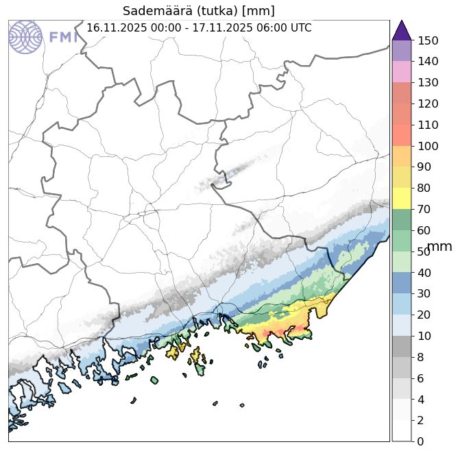
Some kind of quasi-stationary "sea-effect rain" hit yesterday in SE-Finland, producing an extremely localized total of 79 mm in Virolahti Koivuniemi.
This is the highest daily rainfall ever recorded in Finland for the Oct–Dec period.
Radar products indicate even higher amounts, up to 100 mm.
This is the highest daily rainfall ever recorded in Finland for the Oct–Dec period.
Radar products indicate even higher amounts, up to 100 mm.


November 17, 2025 at 8:24 AM
Some kind of quasi-stationary "sea-effect rain" hit yesterday in SE-Finland, producing an extremely localized total of 79 mm in Virolahti Koivuniemi.
This is the highest daily rainfall ever recorded in Finland for the Oct–Dec period.
Radar products indicate even higher amounts, up to 100 mm.
This is the highest daily rainfall ever recorded in Finland for the Oct–Dec period.
Radar products indicate even higher amounts, up to 100 mm.
Temperatures dropped almost to -30 °C last night (coldest -29.5 °C in Sodankylä Vuotso) under strong radiative inversion layer that developed on the surface.
The fresh 20–30 cm snowpack is definitely helping there to cool the surface.
The fresh 20–30 cm snowpack is definitely helping there to cool the surface.


November 17, 2025 at 7:40 AM
Temperatures dropped almost to -30 °C last night (coldest -29.5 °C in Sodankylä Vuotso) under strong radiative inversion layer that developed on the surface.
The fresh 20–30 cm snowpack is definitely helping there to cool the surface.
The fresh 20–30 cm snowpack is definitely helping there to cool the surface.
Breaking: Virolahti Koivuniemi in SE-Finland has provisionally broken the national daily rainfall record for November with 58.2 mm by 21.00 local time and still counting.
www.ilmatieteenlaitos.fi/saa/virolahti
www.ilmatieteenlaitos.fi/saa/virolahti

November 16, 2025 at 7:08 PM
Breaking: Virolahti Koivuniemi in SE-Finland has provisionally broken the national daily rainfall record for November with 58.2 mm by 21.00 local time and still counting.
www.ilmatieteenlaitos.fi/saa/virolahti
www.ilmatieteenlaitos.fi/saa/virolahti
Winter tightens its hold in Lapland. At the moment -28.3 °C in Savukoski Tulppio with > 20 cm of snow. The coldest so far this winter in Finland.
However, much like in 2023, large parts of the northern hemisphere are unusually warm again (except Fennoscandia).
However, much like in 2023, large parts of the northern hemisphere are unusually warm again (except Fennoscandia).

November 16, 2025 at 8:31 AM
Winter tightens its hold in Lapland. At the moment -28.3 °C in Savukoski Tulppio with > 20 cm of snow. The coldest so far this winter in Finland.
However, much like in 2023, large parts of the northern hemisphere are unusually warm again (except Fennoscandia).
However, much like in 2023, large parts of the northern hemisphere are unusually warm again (except Fennoscandia).
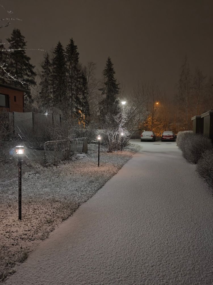
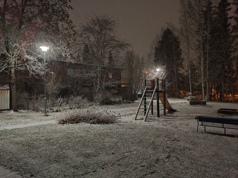
Consequences of the cold air outbreak. First snow of the winter now in Lahti, Finland 🌨️
November 14, 2025 at 4:45 PM
Consequences of the cold air outbreak. First snow of the winter now in Lahti, Finland 🌨️
Syksy on ollut lähes koko maassa ja myös koko maan keskiarvoa tarkastellessa ennätyksellisen lämmin. Lämmin suursäätyyppi muuttuu kuitenkin tällä viikolla.
suomenluonto.fi/ennatyslammi...
@suomenluonto.bsky.social
suomenluonto.fi/ennatyslammi...
@suomenluonto.bsky.social

November 12, 2025 at 1:52 PM
Syksy on ollut lähes koko maassa ja myös koko maan keskiarvoa tarkastellessa ennätyksellisen lämmin. Lämmin suursäätyyppi muuttuu kuitenkin tällä viikolla.
suomenluonto.fi/ennatyslammi...
@suomenluonto.bsky.social
suomenluonto.fi/ennatyslammi...
@suomenluonto.bsky.social
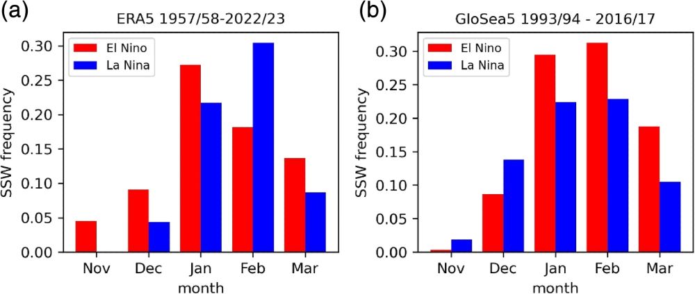
During the satellite era, no November SSW events are known to have occurred; the last robustly documented case was in 1968 (csl.noaa.gov/groups/csl8/...).
In a large sample of seasonal reforecasts (Ineson et al), November SSWs seem to be even rarer.
rmets.onlinelibrary.wiley.com/doi/full/10....
In a large sample of seasonal reforecasts (Ineson et al), November SSWs seem to be even rarer.
rmets.onlinelibrary.wiley.com/doi/full/10....
November 10, 2025 at 11:52 AM
During the satellite era, no November SSW events are known to have occurred; the last robustly documented case was in 1968 (csl.noaa.gov/groups/csl8/...).
In a large sample of seasonal reforecasts (Ineson et al), November SSWs seem to be even rarer.
rmets.onlinelibrary.wiley.com/doi/full/10....
In a large sample of seasonal reforecasts (Ineson et al), November SSWs seem to be even rarer.
rmets.onlinelibrary.wiley.com/doi/full/10....
Latest ECMWF subseasonal forecast shows ensemble mean zonal wind of about 5 m/s at 10 hPa in late November, with roughly 20–30 % of ensemble members indicating a reversal to easterlies (i.e. going < 0 m/s).
This suggests a non-zero probabilty for a major SSW event!
This suggests a non-zero probabilty for a major SSW event!

November 10, 2025 at 11:52 AM
Latest ECMWF subseasonal forecast shows ensemble mean zonal wind of about 5 m/s at 10 hPa in late November, with roughly 20–30 % of ensemble members indicating a reversal to easterlies (i.e. going < 0 m/s).
This suggests a non-zero probabilty for a major SSW event!
This suggests a non-zero probabilty for a major SSW event!
The first week of November (1.-7.11.) was record-warm in Helsinki, Finland. The average temperature was 9.3 °C.
Records have been kept since 1882.
Records have been kept since 1882.

November 8, 2025 at 3:26 PM
The first week of November (1.-7.11.) was record-warm in Helsinki, Finland. The average temperature was 9.3 °C.
Records have been kept since 1882.
Records have been kept since 1882.
Numerot muuttuvat jotenkin maagisesti valkoiseksi.

November 6, 2025 at 11:21 AM
Numerot muuttuvat jotenkin maagisesti valkoiseksi.
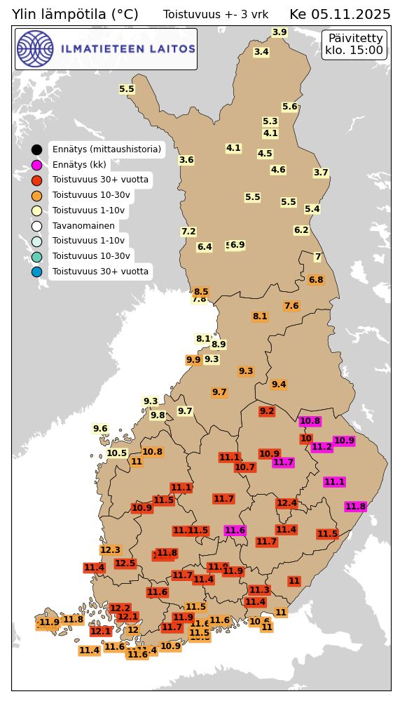
Unprecedentedly warm November day in eastern Finland, especially in North Karelia.
Multiple monthly heat records, including
Tohmajärvi Kemie 11.8 °C
Liperi Joensuu airport 11.1 °C
Juuka Niemelä 11.2 °C
Lieksa Lampela 10.9 °C
Nurmes Valtimo 10.8 °C
(shown with magenta in the map)
Multiple monthly heat records, including
Tohmajärvi Kemie 11.8 °C
Liperi Joensuu airport 11.1 °C
Juuka Niemelä 11.2 °C
Lieksa Lampela 10.9 °C
Nurmes Valtimo 10.8 °C
(shown with magenta in the map)
November 5, 2025 at 1:17 PM
Unprecedentedly warm November day in eastern Finland, especially in North Karelia.
Multiple monthly heat records, including
Tohmajärvi Kemie 11.8 °C
Liperi Joensuu airport 11.1 °C
Juuka Niemelä 11.2 °C
Lieksa Lampela 10.9 °C
Nurmes Valtimo 10.8 °C
(shown with magenta in the map)
Multiple monthly heat records, including
Tohmajärvi Kemie 11.8 °C
Liperi Joensuu airport 11.1 °C
Juuka Niemelä 11.2 °C
Lieksa Lampela 10.9 °C
Nurmes Valtimo 10.8 °C
(shown with magenta in the map)
Exceptionally mild airflow over central Finland today.
Liperi Joensuu airport just set a new November heat record with a temperature of 10.8 °C.
The reading is provisional and may still rise during the day.
Liperi Joensuu airport just set a new November heat record with a temperature of 10.8 °C.
The reading is provisional and may still rise during the day.


November 5, 2025 at 8:13 AM
Exceptionally mild airflow over central Finland today.
Liperi Joensuu airport just set a new November heat record with a temperature of 10.8 °C.
The reading is provisional and may still rise during the day.
Liperi Joensuu airport just set a new November heat record with a temperature of 10.8 °C.
The reading is provisional and may still rise during the day.
Here's Berkeley Earth dataset for Adelaide coordinates (-34.89N, 138.6E), nearest grid cell values.
1914 is there as 8th warmest, with 2013 ranking 1st.
1914 is there as 8th warmest, with 2013 ranking 1st.

November 3, 2025 at 9:38 AM
Here's Berkeley Earth dataset for Adelaide coordinates (-34.89N, 138.6E), nearest grid cell values.
1914 is there as 8th warmest, with 2013 ranking 1st.
1914 is there as 8th warmest, with 2013 ranking 1st.
In the current climate, it is extremely rare for the annual temperature record to be so far in the past, like it is in Finnish Lapland (year 1938).
Only 0.6 % of the land surface area (excluding Antarctica) had their warmest year in the 1930s.
Only 0.6 % of the land surface area (excluding Antarctica) had their warmest year in the 1930s.

November 3, 2025 at 9:05 AM
In the current climate, it is extremely rare for the annual temperature record to be so far in the past, like it is in Finnish Lapland (year 1938).
Only 0.6 % of the land surface area (excluding Antarctica) had their warmest year in the 1930s.
Only 0.6 % of the land surface area (excluding Antarctica) had their warmest year in the 1930s.
Year-to-date temperatures in Sodankylä Tähtelä (northern Fennoscandia) are currently tracking record-high and exceeding the long-standing 1938 record.
The best chance so far to beat the 1938 annual temperature record but it would still require anomalously warm end to the year.
The best chance so far to beat the 1938 annual temperature record but it would still require anomalously warm end to the year.

November 3, 2025 at 9:05 AM
Year-to-date temperatures in Sodankylä Tähtelä (northern Fennoscandia) are currently tracking record-high and exceeding the long-standing 1938 record.
The best chance so far to beat the 1938 annual temperature record but it would still require anomalously warm end to the year.
The best chance so far to beat the 1938 annual temperature record but it would still require anomalously warm end to the year.
It's hard to get a more symmetric and well-defined hurricane structure than the latest satellite images of Melissa.
One of the most intense storms the Atlantic has ever seen and unfortunately, just at the landfall.
One of the most intense storms the Atlantic has ever seen and unfortunately, just at the landfall.

October 28, 2025 at 2:35 PM
It's hard to get a more symmetric and well-defined hurricane structure than the latest satellite images of Melissa.
One of the most intense storms the Atlantic has ever seen and unfortunately, just at the landfall.
One of the most intense storms the Atlantic has ever seen and unfortunately, just at the landfall.
Voimistuminen jatkuu. Nyt 892 hPa ja 185 mph. Jenkkien hurrikaanikeskuksen tiedote on suorasanainen:
THIS IS AN EXTREMELY DANGEROUS AND LIFE-THREATENING SITUATION! TAKE COVER NOW!
Melissa tulee olemaan kaikkien aikojen voimakkain rantautuva hurrikaani Atlantilla.
THIS IS AN EXTREMELY DANGEROUS AND LIFE-THREATENING SITUATION! TAKE COVER NOW!
Melissa tulee olemaan kaikkien aikojen voimakkain rantautuva hurrikaani Atlantilla.

October 28, 2025 at 2:10 PM
Voimistuminen jatkuu. Nyt 892 hPa ja 185 mph. Jenkkien hurrikaanikeskuksen tiedote on suorasanainen:
THIS IS AN EXTREMELY DANGEROUS AND LIFE-THREATENING SITUATION! TAKE COVER NOW!
Melissa tulee olemaan kaikkien aikojen voimakkain rantautuva hurrikaani Atlantilla.
THIS IS AN EXTREMELY DANGEROUS AND LIFE-THREATENING SITUATION! TAKE COVER NOW!
Melissa tulee olemaan kaikkien aikojen voimakkain rantautuva hurrikaani Atlantilla.
Oikeastaan pahin mahdollinen skenaario näyttäisi toteutuvan. Hurrikaani Melissa on jatkanut voimistumistaan juuri ennen rantautumistaan Jamakaille. Maksimikeskituulet puhaltavat nyt 80 m/s, ja pintapaine on laskenut 896 hPa:iin.
Yksi kaikkien aikojen voimakkaimmista myrskyistä Atlantilla.
Yksi kaikkien aikojen voimakkaimmista myrskyistä Atlantilla.

October 28, 2025 at 1:18 PM
Oikeastaan pahin mahdollinen skenaario näyttäisi toteutuvan. Hurrikaani Melissa on jatkanut voimistumistaan juuri ennen rantautumistaan Jamakaille. Maksimikeskituulet puhaltavat nyt 80 m/s, ja pintapaine on laskenut 896 hPa:iin.
Yksi kaikkien aikojen voimakkaimmista myrskyistä Atlantilla.
Yksi kaikkien aikojen voimakkaimmista myrskyistä Atlantilla.
Under the RCP4.5 scenario and collapsed AMOC, René van Westen shows how especially the cold extremes would get worse in the Nordics.
-47 °C in Helsinki would be once in a 10 year event!
-47 °C in Helsinki would be once in a 10 year event!

October 21, 2025 at 11:20 AM
Under the RCP4.5 scenario and collapsed AMOC, René van Westen shows how especially the cold extremes would get worse in the Nordics.
-47 °C in Helsinki would be once in a 10 year event!
-47 °C in Helsinki would be once in a 10 year event!
Nordic Tipping Week in Helsinki. @rahmstorf.bsky.social gave a nice overview on the state of latest research on the risk of AMOC change.

October 21, 2025 at 10:45 AM
Nordic Tipping Week in Helsinki. @rahmstorf.bsky.social gave a nice overview on the state of latest research on the risk of AMOC change.
First snow of the season in Finland has fallen today morning in Enontekiö, Lapland.
This year, the first snow was about three weeks late. Usually the first measurable snow is registered somewhere in the country in late September.
This year, the first snow was about three weeks late. Usually the first measurable snow is registered somewhere in the country in late September.

October 16, 2025 at 6:18 AM
First snow of the season in Finland has fallen today morning in Enontekiö, Lapland.
This year, the first snow was about three weeks late. Usually the first measurable snow is registered somewhere in the country in late September.
This year, the first snow was about three weeks late. Usually the first measurable snow is registered somewhere in the country in late September.
Wow, autumn-to-date mean temperature in Sodankylä, Lapland is currently a full two degrees (!) higher than the previous record.
In Sodankylä, records have been kept since 1908.
In Sodankylä, records have been kept since 1908.

October 9, 2025 at 7:23 AM
Wow, autumn-to-date mean temperature in Sodankylä, Lapland is currently a full two degrees (!) higher than the previous record.
In Sodankylä, records have been kept since 1908.
In Sodankylä, records have been kept since 1908.