


MetService NZ
@metservice.com
New Zealand's weather service. Helping Kiwis be ready, whatever the weather.
⚠️Severe Weather Update🔔
🟠💧The Heavy Rain Warning now only affecting eastern Bay of Plenty and Gisborne/Tairawhiti north of Ruatoria until early tomorrow
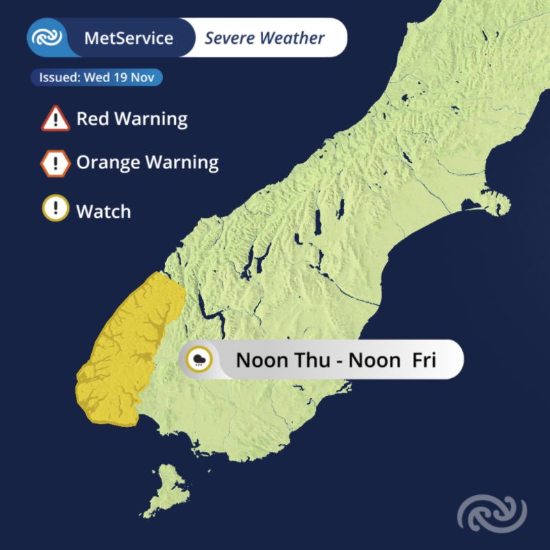
🟡🌧Heavy Rain Watch remains over Fiordland, valid from midday tomorrow
For more: bit.ly/AllWarnings
🟠💧The Heavy Rain Warning now only affecting eastern Bay of Plenty and Gisborne/Tairawhiti north of Ruatoria until early tomorrow
🟡🌧Heavy Rain Watch remains over Fiordland, valid from midday tomorrow
For more: bit.ly/AllWarnings

November 19, 2025 at 7:50 AM
⚠️Severe Weather Update🔔
🟠💧The Heavy Rain Warning now only affecting eastern Bay of Plenty and Gisborne/Tairawhiti north of Ruatoria until early tomorrow
🟡🌧Heavy Rain Watch remains over Fiordland, valid from midday tomorrow
For more: bit.ly/AllWarnings
🟠💧The Heavy Rain Warning now only affecting eastern Bay of Plenty and Gisborne/Tairawhiti north of Ruatoria until early tomorrow
🟡🌧Heavy Rain Watch remains over Fiordland, valid from midday tomorrow
For more: bit.ly/AllWarnings
The wettest weather tracks towards the east where Heavy Rain Warnings remain this afternoon and evening
The main rainband has cleared Auckland and Northland, but showers are still expected
After things clear early Thursday, Fiordland is next in line for possible heavy rain
The main rainband has cleared Auckland and Northland, but showers are still expected
After things clear early Thursday, Fiordland is next in line for possible heavy rain
November 19, 2025 at 12:22 AM
The wettest weather tracks towards the east where Heavy Rain Warnings remain this afternoon and evening
The main rainband has cleared Auckland and Northland, but showers are still expected
After things clear early Thursday, Fiordland is next in line for possible heavy rain
The main rainband has cleared Auckland and Northland, but showers are still expected
After things clear early Thursday, Fiordland is next in line for possible heavy rain
Things feeling balmy?🌴
If last night felt warm and muggy, you're not alone
Nighttime temperatures stayed in the high teens for many
Honourable mentions include
- Waikanae 17.5°C
- Whitianga 17.3°C
- Rotorua 17.2°C
- Lower Hutt 17.1°C
If last night felt warm and muggy, you're not alone
Nighttime temperatures stayed in the high teens for many
Honourable mentions include
- Waikanae 17.5°C
- Whitianga 17.3°C
- Rotorua 17.2°C
- Lower Hutt 17.1°C

November 18, 2025 at 7:30 PM
Things feeling balmy?🌴
If last night felt warm and muggy, you're not alone
Nighttime temperatures stayed in the high teens for many
Honourable mentions include
- Waikanae 17.5°C
- Whitianga 17.3°C
- Rotorua 17.2°C
- Lower Hutt 17.1°C
If last night felt warm and muggy, you're not alone
Nighttime temperatures stayed in the high teens for many
Honourable mentions include
- Waikanae 17.5°C
- Whitianga 17.3°C
- Rotorua 17.2°C
- Lower Hutt 17.1°C
☔️It's a wet start to the day for many parts of the North Island after a soggy night
🌧️Further rain is expected today, with several Watches and Warnings in place - keep an eye out later this morning for any updates
🌧️Further rain is expected today, with several Watches and Warnings in place - keep an eye out later this morning for any updates
November 18, 2025 at 6:53 PM
☔️It's a wet start to the day for many parts of the North Island after a soggy night
🌧️Further rain is expected today, with several Watches and Warnings in place - keep an eye out later this morning for any updates
🌧️Further rain is expected today, with several Watches and Warnings in place - keep an eye out later this morning for any updates
🔶🟡🚨
Server Weather Watches and Warnings have been updated!
To view the details please go to the MetService Watches and Warning page here
metservice.com/warnings/home
Server Weather Watches and Warnings have been updated!
To view the details please go to the MetService Watches and Warning page here
metservice.com/warnings/home

November 18, 2025 at 8:20 AM
🔶🟡🚨
Server Weather Watches and Warnings have been updated!
To view the details please go to the MetService Watches and Warning page here
metservice.com/warnings/home
Server Weather Watches and Warnings have been updated!
To view the details please go to the MetService Watches and Warning page here
metservice.com/warnings/home
Among all the severe weather, you may have missed that we passed our 1000th post on bluesky today 🥳
Spread the word and tell your friends we're here as we creep towards 1000 followers. 36 to go!
Spread the word and tell your friends we're here as we creep towards 1000 followers. 36 to go!
November 18, 2025 at 2:40 AM
Among all the severe weather, you may have missed that we passed our 1000th post on bluesky today 🥳
Spread the word and tell your friends we're here as we creep towards 1000 followers. 36 to go!
Spread the word and tell your friends we're here as we creep towards 1000 followers. 36 to go!
A rain band is sweeping through and may bring bursts of heavier rain to some areas
Keep an eye on the rain radar this afternoon and evening for further rain bands moving through
Keep an eye on the rain radar this afternoon and evening for further rain bands moving through
November 18, 2025 at 12:22 AM
A rain band is sweeping through and may bring bursts of heavier rain to some areas
Keep an eye on the rain radar this afternoon and evening for further rain bands moving through
Keep an eye on the rain radar this afternoon and evening for further rain bands moving through
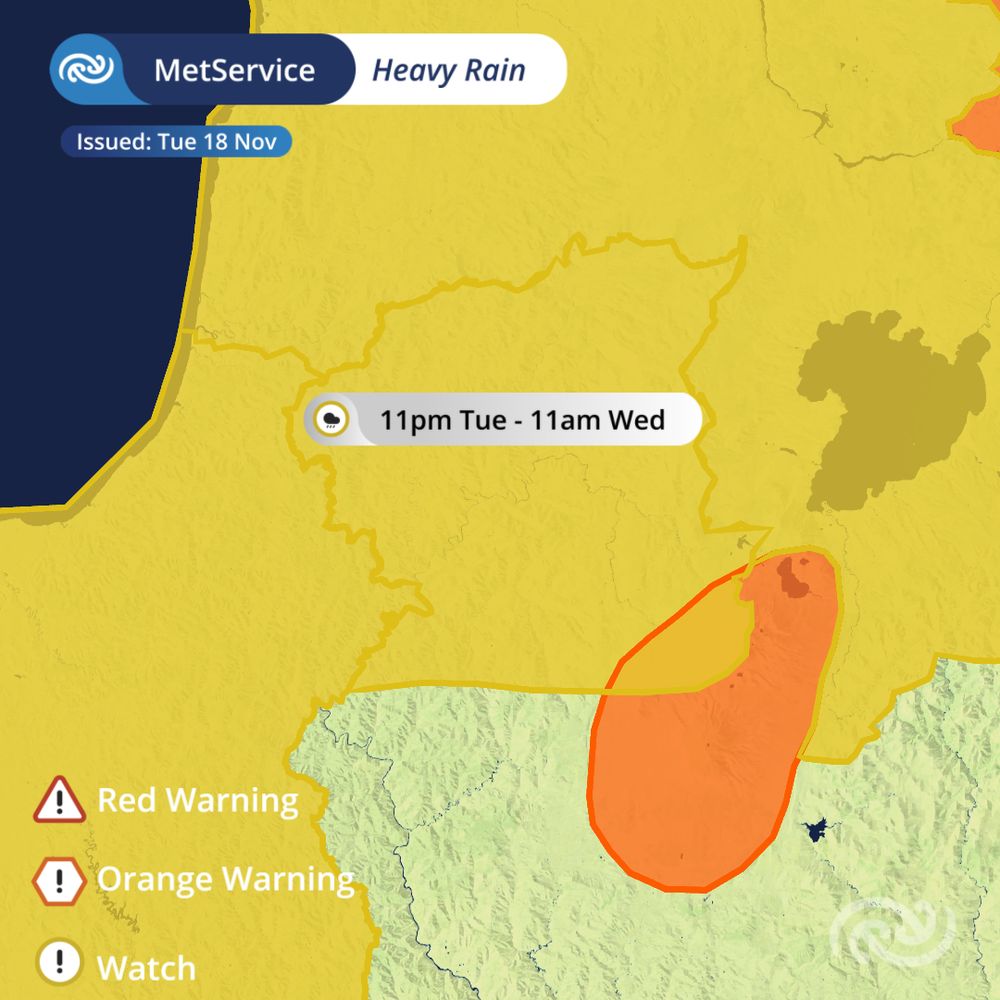
🌧️ Severe Thunderstorm Watch issued for Bay of Plenty 🌧️
Narrow bands of heavy rain are moving westward across the Bay of Plenty today. There is a risk of downpours with or without lightning.
This watch is before the wider orange heavy rain warning that begins later today.
Narrow bands of heavy rain are moving westward across the Bay of Plenty today. There is a risk of downpours with or without lightning.
This watch is before the wider orange heavy rain warning that begins later today.

November 17, 2025 at 10:57 PM
🌧️ Severe Thunderstorm Watch issued for Bay of Plenty 🌧️
Narrow bands of heavy rain are moving westward across the Bay of Plenty today. There is a risk of downpours with or without lightning.
This watch is before the wider orange heavy rain warning that begins later today.
Narrow bands of heavy rain are moving westward across the Bay of Plenty today. There is a risk of downpours with or without lightning.
This watch is before the wider orange heavy rain warning that begins later today.
⚠️ Severe Weather Update for Tuesday the 18th of November ⚠️
🌧️ Parts of the North Island could see downpours over the next 24 hours, so stay up to date, and listen to your local emergency management and transport authorities.
🌧️ Parts of the North Island could see downpours over the next 24 hours, so stay up to date, and listen to your local emergency management and transport authorities.


November 17, 2025 at 10:26 PM
⚠️ Severe Weather Update for Tuesday the 18th of November ⚠️
🌧️ Parts of the North Island could see downpours over the next 24 hours, so stay up to date, and listen to your local emergency management and transport authorities.
🌧️ Parts of the North Island could see downpours over the next 24 hours, so stay up to date, and listen to your local emergency management and transport authorities.
⚠️ Heavy Rain Watches issued for Auckland, parts of Northland and Taumarunui
🦺 Keep up to date with the latest information at metservice.com/warnings/home
🦺 Keep up to date with the latest information at metservice.com/warnings/home

November 17, 2025 at 9:47 PM
⚠️ Heavy Rain Watches issued for Auckland, parts of Northland and Taumarunui
🦺 Keep up to date with the latest information at metservice.com/warnings/home
🦺 Keep up to date with the latest information at metservice.com/warnings/home
Ata mārie everyone 🌄
Its been a gorgeous sunrise today here in Wellington, unfortunately that's not been the case for everyone with rain for the western South Island and central North Island.
An update on our weather watches and warning will be out later this morning, so keep an eye out for that!
Its been a gorgeous sunrise today here in Wellington, unfortunately that's not been the case for everyone with rain for the western South Island and central North Island.
An update on our weather watches and warning will be out later this morning, so keep an eye out for that!

November 17, 2025 at 6:58 PM
Ata mārie everyone 🌄
Its been a gorgeous sunrise today here in Wellington, unfortunately that's not been the case for everyone with rain for the western South Island and central North Island.
An update on our weather watches and warning will be out later this morning, so keep an eye out for that!
Its been a gorgeous sunrise today here in Wellington, unfortunately that's not been the case for everyone with rain for the western South Island and central North Island.
An update on our weather watches and warning will be out later this morning, so keep an eye out for that!
🌧️Rain is heading the North Island's way Tuesday🌧️
While rainfall isn't forecast to reach warning amounts over the whole region, some spots in Northland and Auckland could see heavy falls, so stay weather aware and keep an eye on the radar tomorrow.
www.metservice.com/maps-radar/r...
While rainfall isn't forecast to reach warning amounts over the whole region, some spots in Northland and Auckland could see heavy falls, so stay weather aware and keep an eye on the radar tomorrow.
www.metservice.com/maps-radar/r...

November 17, 2025 at 1:40 AM
🌧️Rain is heading the North Island's way Tuesday🌧️
While rainfall isn't forecast to reach warning amounts over the whole region, some spots in Northland and Auckland could see heavy falls, so stay weather aware and keep an eye on the radar tomorrow.
www.metservice.com/maps-radar/r...
While rainfall isn't forecast to reach warning amounts over the whole region, some spots in Northland and Auckland could see heavy falls, so stay weather aware and keep an eye on the radar tomorrow.
www.metservice.com/maps-radar/r...
🟠 Severe weather update, Monday 17 Nov 🟠
Heavy Rain Warnings start from Monday night in the South Island, and Tuesday afternoon in the north.
A strong wind watch is also in place for Fiordland and western Southland.
Keep up to date with the latest warnings at www.metservice.com/warnings/home
Heavy Rain Warnings start from Monday night in the South Island, and Tuesday afternoon in the north.
A strong wind watch is also in place for Fiordland and western Southland.
Keep up to date with the latest warnings at www.metservice.com/warnings/home


November 16, 2025 at 10:58 PM
🟠 Severe weather update, Monday 17 Nov 🟠
Heavy Rain Warnings start from Monday night in the South Island, and Tuesday afternoon in the north.
A strong wind watch is also in place for Fiordland and western Southland.
Keep up to date with the latest warnings at www.metservice.com/warnings/home
Heavy Rain Warnings start from Monday night in the South Island, and Tuesday afternoon in the north.
A strong wind watch is also in place for Fiordland and western Southland.
Keep up to date with the latest warnings at www.metservice.com/warnings/home
🌞Mōrena everyone, here are your overnight temperatures.
🌡️Warm nights are here to stay, with a 6am temperature of 18 degrees in Tauranga!
🤔Did you notice it was 10 degrees colder in Whitianga? That's thanks to a clear night helping the town cool off.
🌡️Warm nights are here to stay, with a 6am temperature of 18 degrees in Tauranga!
🤔Did you notice it was 10 degrees colder in Whitianga? That's thanks to a clear night helping the town cool off.

November 16, 2025 at 7:38 PM
🌞Mōrena everyone, here are your overnight temperatures.
🌡️Warm nights are here to stay, with a 6am temperature of 18 degrees in Tauranga!
🤔Did you notice it was 10 degrees colder in Whitianga? That's thanks to a clear night helping the town cool off.
🌡️Warm nights are here to stay, with a 6am temperature of 18 degrees in Tauranga!
🤔Did you notice it was 10 degrees colder in Whitianga? That's thanks to a clear night helping the town cool off.
⛈️A Severe Thunderstorm Warning has been issued for the Hurunui, Selwyn, Waimakariri and Christchurch City.
Details here bit.ly/STWarning
Details here bit.ly/STWarning

November 15, 2025 at 1:02 AM
⛈️A Severe Thunderstorm Warning has been issued for the Hurunui, Selwyn, Waimakariri and Christchurch City.
Details here bit.ly/STWarning
Details here bit.ly/STWarning
⛈️A Severe Thunderstorm Warning has been issued for the Timaru, Waimate area, South Island.
Details here
bit.ly/STWarning
Details here
bit.ly/STWarning

November 15, 2025 at 12:19 AM
⛈️A Severe Thunderstorm Warning has been issued for the Timaru, Waimate area, South Island.
Details here
bit.ly/STWarning
Details here
bit.ly/STWarning
🌧️A narrow front containing some heavy showers is moving slowly northeast across the North Island.
📡And spreading over Auckland as I type this heads-up!
View the radar images here
bit.ly/NZRainRadar
Your weather today
bit.ly/metservicenz
📡And spreading over Auckland as I type this heads-up!
View the radar images here
bit.ly/NZRainRadar
Your weather today
bit.ly/metservicenz

November 14, 2025 at 9:26 PM
🌧️A narrow front containing some heavy showers is moving slowly northeast across the North Island.
📡And spreading over Auckland as I type this heads-up!
View the radar images here
bit.ly/NZRainRadar
Your weather today
bit.ly/metservicenz
📡And spreading over Auckland as I type this heads-up!
View the radar images here
bit.ly/NZRainRadar
Your weather today
bit.ly/metservicenz
🌅Ata mārie, good morning Aotearoa New Zealand .
🌡️At 7am temperatures ranged from 5°C in Oamaru and Wanaka to 17°C up north in Tauranga and Whitianga.
Check your weekend forecast here
bit.ly/metservicenz
🌡️At 7am temperatures ranged from 5°C in Oamaru and Wanaka to 17°C up north in Tauranga and Whitianga.
Check your weekend forecast here
bit.ly/metservicenz

November 14, 2025 at 7:14 PM
🌅Ata mārie, good morning Aotearoa New Zealand .
🌡️At 7am temperatures ranged from 5°C in Oamaru and Wanaka to 17°C up north in Tauranga and Whitianga.
Check your weekend forecast here
bit.ly/metservicenz
🌡️At 7am temperatures ranged from 5°C in Oamaru and Wanaka to 17°C up north in Tauranga and Whitianga.
Check your weekend forecast here
bit.ly/metservicenz
Heads up eastern North Island⛈️
A Severe Thunderstorm Watch is in place this afternoon and evening🟡 Some thunderstorms may be severe, bringing:
💧Heavy downpours in localised areas
🧊Large hail
🚗Hazardous driving conditions
Full details can be found at www.metservice.com/warnings/home
A Severe Thunderstorm Watch is in place this afternoon and evening🟡 Some thunderstorms may be severe, bringing:
💧Heavy downpours in localised areas
🧊Large hail
🚗Hazardous driving conditions
Full details can be found at www.metservice.com/warnings/home

November 13, 2025 at 9:30 PM
Heads up eastern North Island⛈️
A Severe Thunderstorm Watch is in place this afternoon and evening🟡 Some thunderstorms may be severe, bringing:
💧Heavy downpours in localised areas
🧊Large hail
🚗Hazardous driving conditions
Full details can be found at www.metservice.com/warnings/home
A Severe Thunderstorm Watch is in place this afternoon and evening🟡 Some thunderstorms may be severe, bringing:
💧Heavy downpours in localised areas
🧊Large hail
🚗Hazardous driving conditions
Full details can be found at www.metservice.com/warnings/home
Mōrena all happy Friday! A much sunnier, drier and warmer day for Canterbury for the start of your long weekend. For the North Island, keep an eye on the radar today. Here's your Friday forecast, youtu.be/QytrM3Pbtek

NZ Weather Forecast - Friday 14th November 2025
YouTube video by MetService - NZ Weather
youtu.be
November 13, 2025 at 5:49 PM
Mōrena all happy Friday! A much sunnier, drier and warmer day for Canterbury for the start of your long weekend. For the North Island, keep an eye on the radar today. Here's your Friday forecast, youtu.be/QytrM3Pbtek
🔔Here’s your weather look from the sky🛰️📡
Showers persisting for the North Island; no lightning strike yet🌩, but the risk for thunderstorms remains for this afternoon and evening, downpours and hail also possible in places⛈🧊
Overcast with rain for the South Island🌧☔
Rain radar: bit.ly/NZRainRadar
Showers persisting for the North Island; no lightning strike yet🌩, but the risk for thunderstorms remains for this afternoon and evening, downpours and hail also possible in places⛈🧊
Overcast with rain for the South Island🌧☔
Rain radar: bit.ly/NZRainRadar

November 13, 2025 at 1:14 AM
🔔Here’s your weather look from the sky🛰️📡
Showers persisting for the North Island; no lightning strike yet🌩, but the risk for thunderstorms remains for this afternoon and evening, downpours and hail also possible in places⛈🧊
Overcast with rain for the South Island🌧☔
Rain radar: bit.ly/NZRainRadar
Showers persisting for the North Island; no lightning strike yet🌩, but the risk for thunderstorms remains for this afternoon and evening, downpours and hail also possible in places⛈🧊
Overcast with rain for the South Island🌧☔
Rain radar: bit.ly/NZRainRadar
⚠️Severe Weather Update
🟡💨There has been an update to the Strong Wind Watches affecting the North Island, the only affected areas now are Wellington and Wairarapa
North to northwest winds may approach severe gale with gust speeds reaching 90 km/h in exposed places🌬
For more: bit.ly/AllWarnings
🟡💨There has been an update to the Strong Wind Watches affecting the North Island, the only affected areas now are Wellington and Wairarapa
North to northwest winds may approach severe gale with gust speeds reaching 90 km/h in exposed places🌬
For more: bit.ly/AllWarnings

November 12, 2025 at 9:22 PM
⚠️Severe Weather Update
🟡💨There has been an update to the Strong Wind Watches affecting the North Island, the only affected areas now are Wellington and Wairarapa
North to northwest winds may approach severe gale with gust speeds reaching 90 km/h in exposed places🌬
For more: bit.ly/AllWarnings
🟡💨There has been an update to the Strong Wind Watches affecting the North Island, the only affected areas now are Wellington and Wairarapa
North to northwest winds may approach severe gale with gust speeds reaching 90 km/h in exposed places🌬
For more: bit.ly/AllWarnings
It’s a rainy day ahead New Zealand☔
That overnight rain persists through the day and is slowly moving south🌧️⬇
Don’t be surprised if you hear a rumble 🌩 in the north. Much of the North Island has a moderate risk for thunderstorms with bursts of heavier falls and localized downpours also possible⛈
That overnight rain persists through the day and is slowly moving south🌧️⬇
Don’t be surprised if you hear a rumble 🌩 in the north. Much of the North Island has a moderate risk for thunderstorms with bursts of heavier falls and localized downpours also possible⛈
November 12, 2025 at 7:09 PM
It’s a rainy day ahead New Zealand☔
That overnight rain persists through the day and is slowly moving south🌧️⬇
Don’t be surprised if you hear a rumble 🌩 in the north. Much of the North Island has a moderate risk for thunderstorms with bursts of heavier falls and localized downpours also possible⛈
That overnight rain persists through the day and is slowly moving south🌧️⬇
Don’t be surprised if you hear a rumble 🌩 in the north. Much of the North Island has a moderate risk for thunderstorms with bursts of heavier falls and localized downpours also possible⛈
🌦️Weather updates: Showers are building!
It's starting to get wet in the South Island, and it will be even wetter this afternoon and evening.
It's starting to get wet in the South Island, and it will be even wetter this afternoon and evening.
November 10, 2025 at 1:49 AM
🌦️Weather updates: Showers are building!
It's starting to get wet in the South Island, and it will be even wetter this afternoon and evening.
It's starting to get wet in the South Island, and it will be even wetter this afternoon and evening.
Keen for Cup Day? 🐴 Here's a visualisation of the weather Christchurch can expect on Tuesday.
Don't forget your sunscreen! 🌞
Don't forget your sunscreen! 🌞
November 10, 2025 at 12:35 AM
Keen for Cup Day? 🐴 Here's a visualisation of the weather Christchurch can expect on Tuesday.
Don't forget your sunscreen! 🌞
Don't forget your sunscreen! 🌞