


Malcolm Meyer
@malcolmmeyer.com
🗺️ Freelance -geospatial- web developer ~ gardener ~ father ~ citizen ~ reggae - 'Hope without optimism.' 👨💻
first images coming out from Maxar -

October 31, 2025 at 1:23 AM
first images coming out from Maxar -
where is the open commercial satellite data for #melissa #Jamaica ? I mean maybe my script is broken 🤷 - we can only hope that's it #gis #opendata #disasters #disasterresponse
Maxar did release before imagery but nothing new yet...
Maxar did release before imagery but nothing new yet...

October 30, 2025 at 3:55 PM
where is the open commercial satellite data for #melissa #Jamaica ? I mean maybe my script is broken 🤷 - we can only hope that's it #gis #opendata #disasters #disasterresponse
Maxar did release before imagery but nothing new yet...
Maxar did release before imagery but nothing new yet...
Is it possible to have high quality printed maps from mapbox/maplibre...of course it is! If you want to get inspired for your next open source project, come check out my talk on Wednesday at #FOSS4GNA on one city's ongoing transition to an open source GIS solution.
#postgresql #webmaps #foss4g
#postgresql #webmaps #foss4g

October 30, 2025 at 3:18 PM
Is it possible to have high quality printed maps from mapbox/maplibre...of course it is! If you want to get inspired for your next open source project, come check out my talk on Wednesday at #FOSS4GNA on one city's ongoing transition to an open source GIS solution.
#postgresql #webmaps #foss4g
#postgresql #webmaps #foss4g
#duckdb and #deckgl have come a long way, amazing what can be done directly in the browser @developmentseed.org developmentseed.org/spatial-acce...

October 18, 2025 at 9:31 PM
#duckdb and #deckgl have come a long way, amazing what can be done directly in the browser @developmentseed.org developmentseed.org/spatial-acce...

August 13, 2025 at 12:03 AM
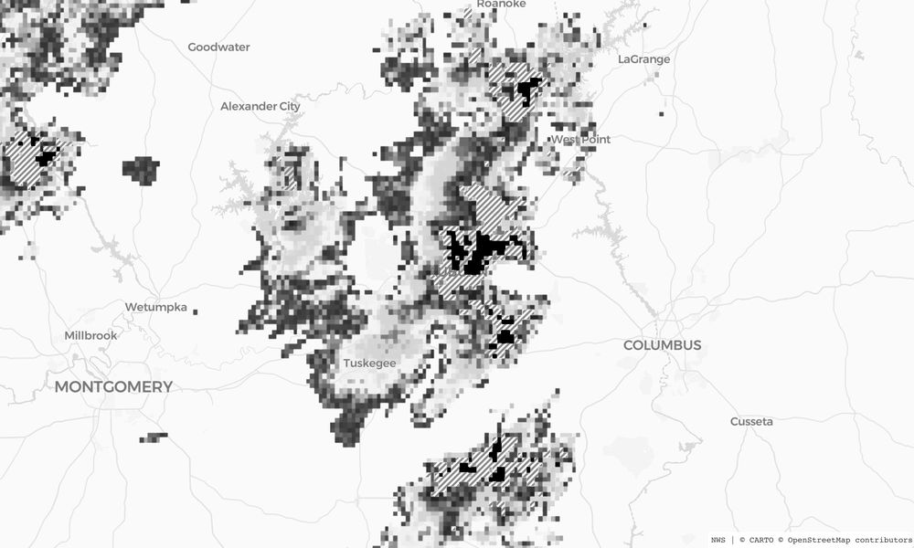
added lines for the medium-level precipitation, and black for the red heavy precipitation levels -
July 18, 2025 at 7:04 PM
added lines for the medium-level precipitation, and black for the red heavy precipitation levels -
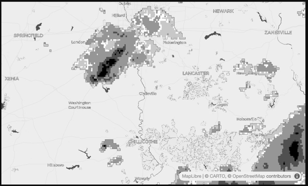
testing out my weather radar map-to-image for use in the TRMNL Image plugin - coming along nicely! @usetrmnl.com #nws #gis #maplibre
July 16, 2025 at 11:08 PM
testing out my weather radar map-to-image for use in the TRMNL Image plugin - coming along nicely! @usetrmnl.com #nws #gis #maplibre
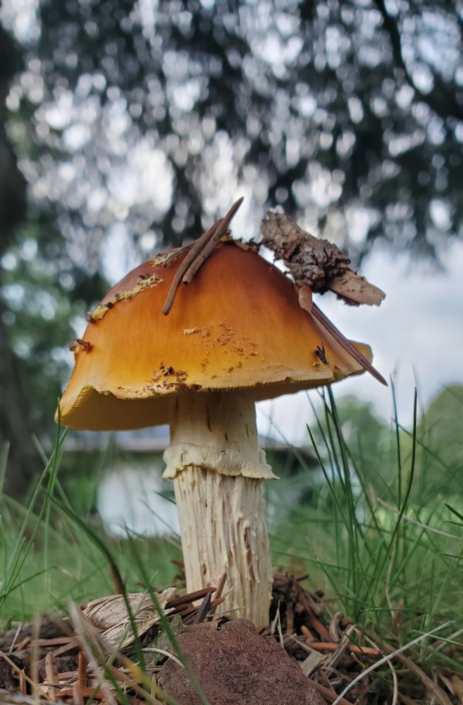
People on here seem to like mushrooms 🍄 so, here's a mushroom
June 16, 2025 at 11:02 PM
People on here seem to like mushrooms 🍄 so, here's a mushroom
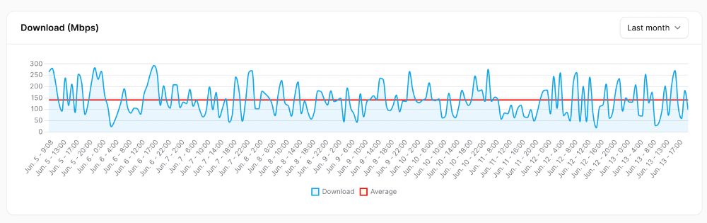
added speedtest tracker to my self-hosted server setup and now I see what you pay for 300 Mbps vs what your get 140 Mbps
#monopoly #Internet #digitaldivide
#monopoly #Internet #digitaldivide
June 14, 2025 at 12:31 AM
added speedtest tracker to my self-hosted server setup and now I see what you pay for 300 Mbps vs what your get 140 Mbps
#monopoly #Internet #digitaldivide
#monopoly #Internet #digitaldivide
May 23, 2025 at 7:03 PM
Flatgeobuf on-demand vector tiling performance on a $5 4-core server *almost* good enough. The FGB process uses http range requests with minimal latency as the data host is the web server not a cloud bucket. More/faster server cores (my m2 Mac) make it much more viable. #gis #gischat #webmaps #cng
May 4, 2025 at 12:27 PM
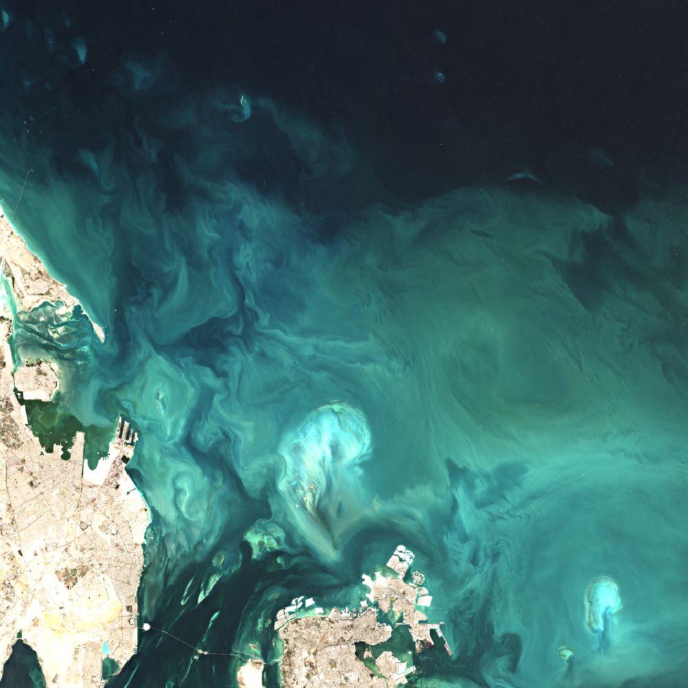
algal Blooms on the Mississippi River delta via Sentinel 2
#gis #gischat #remotesensing
sentinel-spy.netlify.app
#gis #gischat #remotesensing
sentinel-spy.netlify.app
April 17, 2025 at 2:05 PM
algal Blooms on the Mississippi River delta via Sentinel 2
#gis #gischat #remotesensing
sentinel-spy.netlify.app
#gis #gischat #remotesensing
sentinel-spy.netlify.app
April 12, 2025 at 12:55 AM
Satellite imagery available now from Maxar imagery for the Myanmar earthquake via their stac catalog -
www.mappingdisasters.com#9.68/21.792/...
other open source imagery can be found via Earth Search console.earth-search.aws.element84.com
#gis #gischat #remotesensing #mappingdisasters
www.mappingdisasters.com#9.68/21.792/...
other open source imagery can be found via Earth Search console.earth-search.aws.element84.com
#gis #gischat #remotesensing #mappingdisasters

April 4, 2025 at 1:59 PM
Satellite imagery available now from Maxar imagery for the Myanmar earthquake via their stac catalog -
www.mappingdisasters.com#9.68/21.792/...
other open source imagery can be found via Earth Search console.earth-search.aws.element84.com
#gis #gischat #remotesensing #mappingdisasters
www.mappingdisasters.com#9.68/21.792/...
other open source imagery can be found via Earth Search console.earth-search.aws.element84.com
#gis #gischat #remotesensing #mappingdisasters


boiling some sap today so thought I would share some sap maps #maple #syrup 🍁🥞 #maps www.thesouthernhighlander.org/maple-sugaring
images.squarespace-cdn.com/content/v1/5...
images.squarespace-cdn.com/content/v1/5...

March 12, 2025 at 2:27 PM
boiling some sap today so thought I would share some sap maps #maple #syrup 🍁🥞 #maps www.thesouthernhighlander.org/maple-sugaring
images.squarespace-cdn.com/content/v1/5...
images.squarespace-cdn.com/content/v1/5...
#wyoming #grandtetons #nationalparks I want to go back - hopefully there will be a park to go back to

February 19, 2025 at 2:44 PM
#wyoming #grandtetons #nationalparks I want to go back - hopefully there will be a park to go back to
from a very snowy Feb in the Midwest #fsprintmonday

February 18, 2025 at 12:56 AM
from a very snowy Feb in the Midwest #fsprintmonday
quick test of github.com/uav4geo/GeoD... #gis #remotesensing #geospatial on #maxar post-disaster satellite imagery - geodeep raster.tif buildings - decent on standing buildings esp for such a simple install and process - but not useful for damage detection


February 13, 2025 at 1:30 PM
quick test of github.com/uav4geo/GeoD... #gis #remotesensing #geospatial on #maxar post-disaster satellite imagery - geodeep raster.tif buildings - decent on standing buildings esp for such a simple install and process - but not useful for damage detection
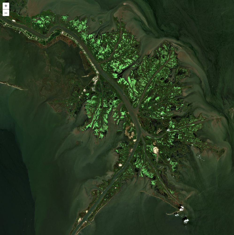
with around 6000? images per day it's hard to pic just 4 - but here's 4 more sentinel-2 images from my image filter and analyzer - US West Coast, Caribbean, desert #gis #gischat #remotesensing #sentinel2 #earthobservation


February 11, 2025 at 3:27 PM
with around 6000? images per day it's hard to pic just 4 - but here's 4 more sentinel-2 images from my image filter and analyzer - US West Coast, Caribbean, desert #gis #gischat #remotesensing #sentinel2 #earthobservation
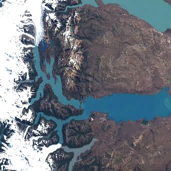
semi-random sentinel-2 images from the past 24hrs - limited alt text available at this time #gis #gischat #dataviz #remotesensing #geospatial


February 8, 2025 at 2:08 PM
semi-random sentinel-2 images from the past 24hrs - limited alt text available at this time #gis #gischat #dataviz #remotesensing #geospatial
Maxar open data for the LA Wildfires - 400 images - registry.opendata.aws/maxar-open-d...
#gis #disasterresponse #opendata
#gis #disasterresponse #opendata

January 20, 2025 at 2:49 PM
Maxar open data for the LA Wildfires - 400 images - registry.opendata.aws/maxar-open-d...
#gis #disasterresponse #opendata
#gis #disasterresponse #opendata
apparently 1TB was not enough - just couldnt bring myself to shell out the $$ for 2TB 😵💫

January 17, 2025 at 2:41 PM
apparently 1TB was not enough - just couldnt bring myself to shell out the $$ for 2TB 😵💫

January 11, 2025 at 10:25 PM