


Louisa Loveluck
@leloveluck.bsky.social
@washingtonpost.com foreign correspondent covering international crises, including the Israel-Gaza war. Based in London. Previously: Baghdad, Beirut, Cairo. Got a tip? DM for Signal.
No attempt to elide culpability intended. Eyewitnesses say it's most commonly IDF forces opening fire, but whistleblowers have also described contractors doing so, and in some cases, doctors report that injuries are sustained from the crowd.
August 22, 2025 at 9:22 AM
No attempt to elide culpability intended. Eyewitnesses say it's most commonly IDF forces opening fire, but whistleblowers have also described contractors doing so, and in some cases, doctors report that injuries are sustained from the crowd.
Reposted by Louisa Loveluck

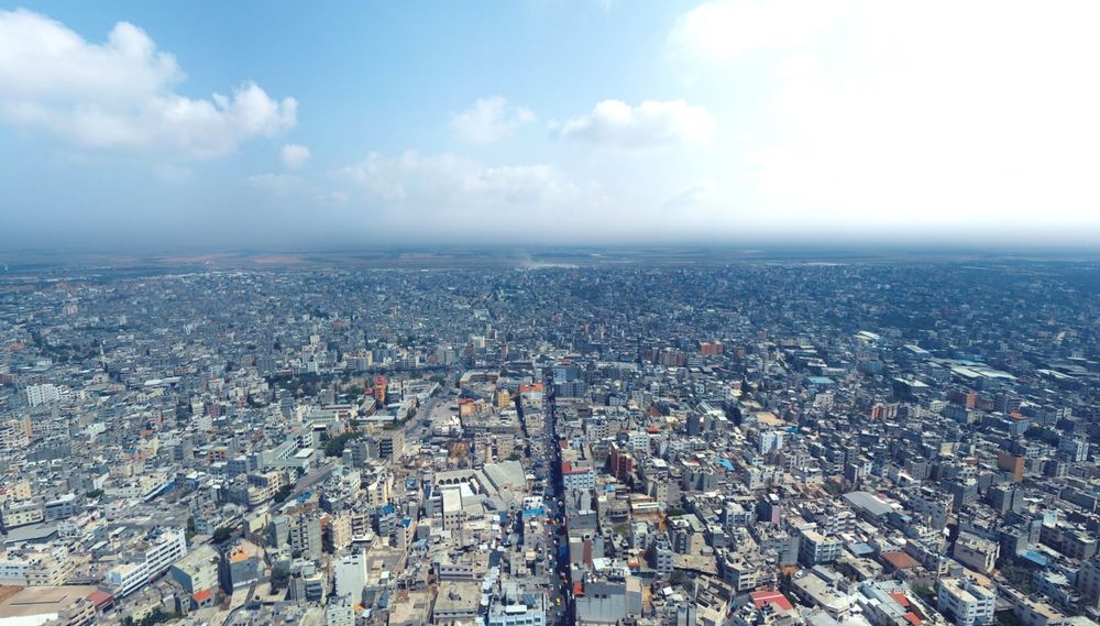
For another comparison, there's also an aerial view from a similar perspective, though at lower altitude since it's from a drone photographer, here on Facebook from 2019: www.facebook.com/photo/?fbid=...
The drone photo is closer to 31.5057, 34.4619 whereas the plane photo is closer to the coast.
The drone photo is closer to 31.5057, 34.4619 whereas the plane photo is closer to the coast.
August 1, 2025 at 7:35 PM
For another comparison, there's also an aerial view from a similar perspective, though at lower altitude since it's from a drone photographer, here on Facebook from 2019: www.facebook.com/photo/?fbid=...
The drone photo is closer to 31.5057, 34.4619 whereas the plane photo is closer to the coast.
The drone photo is closer to 31.5057, 34.4619 whereas the plane photo is closer to the coast.
Reposted by Louisa Loveluck
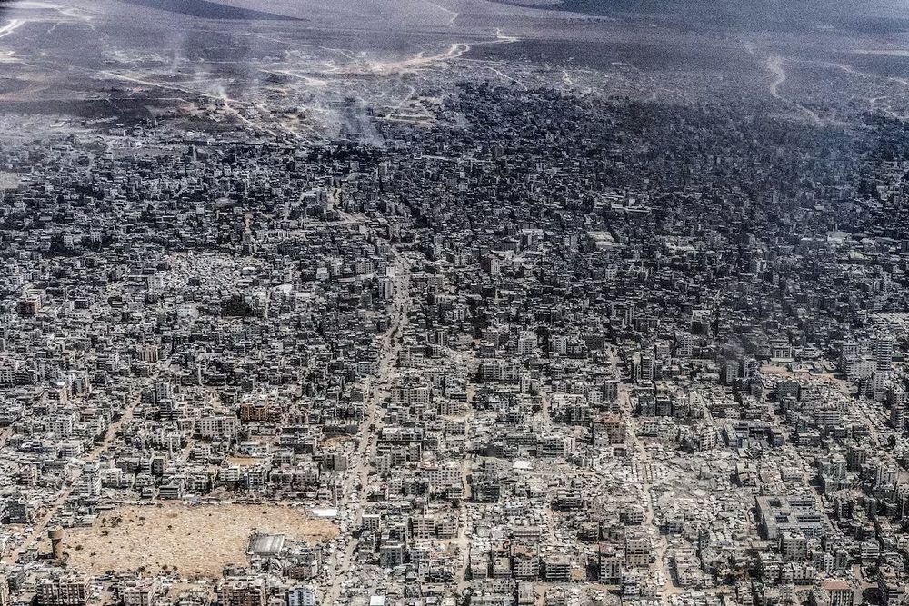
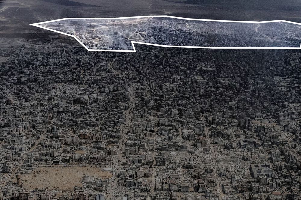
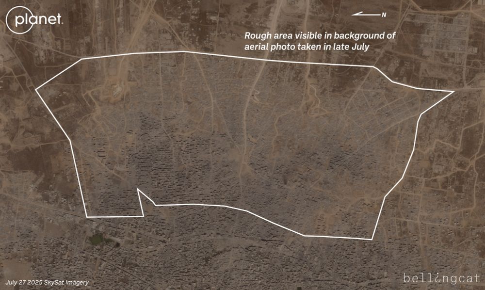
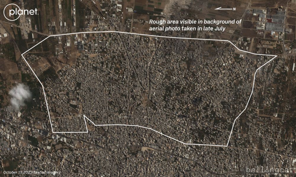
Can just barely see it but the massive destruction in Gaza City's eastern neighborhoods such as Shejaiya and Tuffah is visible in the background of the photo. When compared with a satellite image taken a week after the war started, can see thousands of homes have been razed.
August 1, 2025 at 7:31 PM
Can just barely see it but the massive destruction in Gaza City's eastern neighborhoods such as Shejaiya and Tuffah is visible in the background of the photo. When compared with a satellite image taken a week after the war started, can see thousands of homes have been razed.
Thank you for sharing this, Jake.
August 1, 2025 at 8:07 PM
Thank you for sharing this, Jake.
“My dear sister, it’s hard, it’s really hard for me to describe to you all of these children’s injuries,” he said. “How can a child who weighs between 5 to 10kg bear a missile,” he asked.
www.washingtonpost.com/world/2025/0...
www.washingtonpost.com/world/2025/0...

Gaza doctor’s death in Israeli strike devastates medical community
Marwan al-Sultan, director of Gaza’s Indonesian Hospital, provided harrowing accounts of how the health care system collapsed over the course of the war.
www.washingtonpost.com
July 17, 2025 at 9:18 AM
“My dear sister, it’s hard, it’s really hard for me to describe to you all of these children’s injuries,” he said. “How can a child who weighs between 5 to 10kg bear a missile,” he asked.
www.washingtonpost.com/world/2025/0...
www.washingtonpost.com/world/2025/0...
In one of Sultan’s final messages to Post reporters, on May 14, he had listed the names of 21 people brought dead to the hospital, most no older than nine years old. Some of them had arrived in pieces, he said.
July 17, 2025 at 9:18 AM
In one of Sultan’s final messages to Post reporters, on May 14, he had listed the names of 21 people brought dead to the hospital, most no older than nine years old. Some of them had arrived in pieces, he said.
Within weeks, the Indonesian Hospital itself was under siege and almost out of equipment, and Sultan issued the first of what would become a series of urgent appeals to the international community, urging the protection of his facility and team.
July 17, 2025 at 9:18 AM
Within weeks, the Indonesian Hospital itself was under siege and almost out of equipment, and Sultan issued the first of what would become a series of urgent appeals to the international community, urging the protection of his facility and team.
“An entire densely populated square was targeted at a time when people were sitting safely at home,” he said in a message. “People who work with us now have received their relatives who were killed or injured.”
July 17, 2025 at 9:18 AM
“An entire densely populated square was targeted at a time when people were sitting safely at home,” he said in a message. “People who work with us now have received their relatives who were killed or injured.”
By November, Gaza’s telecommunications network was on its knees and Sultan said that his staff had been forced to use loudspeakers to direct medics to the Jabalya refugee camp, where hundreds of civilians had been buried under rubble in one of the war’s deadliest Israeli strikes.
July 17, 2025 at 9:18 AM
By November, Gaza’s telecommunications network was on its knees and Sultan said that his staff had been forced to use loudspeakers to direct medics to the Jabalya refugee camp, where hundreds of civilians had been buried under rubble in one of the war’s deadliest Israeli strikes.
October: As Israeli troops readied a wide-scale ground invasion, Sultan described the shock of the moment inside Indonesian Hospital as like being “in a dream.” So heavy was the influx of casualties from Israeli bombing that he barely left the hospital — and already feared being killed if he did.
July 17, 2025 at 9:18 AM
October: As Israeli troops readied a wide-scale ground invasion, Sultan described the shock of the moment inside Indonesian Hospital as like being “in a dream.” So heavy was the influx of casualties from Israeli bombing that he barely left the hospital — and already feared being killed if he did.