


Joackiie
@joackiie.bsky.social
Senior meteorologist (M. Sc.), retired 😊
Passionate about all weather and science. Hiking and skiing.
Passionate about all weather and science. Hiking and skiing.
Today, the 1st of December, marks the commencement of the meteorological winter—a date designated just for climatological record-keeping purposes.
Snow cover today ↙️, as indicated by both model projections and select measurements, compared to the same date last year ↘️
Snow cover today ↙️, as indicated by both model projections and select measurements, compared to the same date last year ↘️


December 1, 2025 at 12:07 PM
Today, the 1st of December, marks the commencement of the meteorological winter—a date designated just for climatological record-keeping purposes.
Snow cover today ↙️, as indicated by both model projections and select measurements, compared to the same date last year ↘️
Snow cover today ↙️, as indicated by both model projections and select measurements, compared to the same date last year ↘️
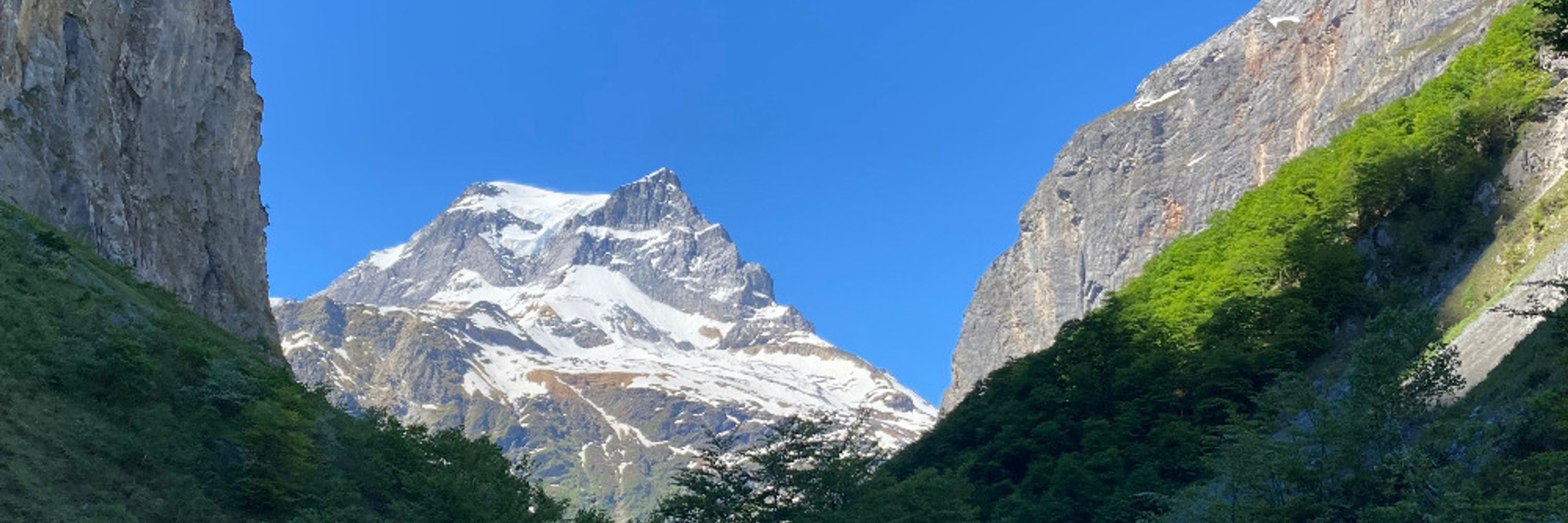
Once again sunny early-winter day in Switzerland, seen by Terra/Modis.
North of the Alps - above 600/700m amsl - now significant more snow than usual (source SLF).
Next week southern side of the Alps will finally also get the white stuff :-)
North of the Alps - above 600/700m amsl - now significant more snow than usual (source SLF).
Next week southern side of the Alps will finally also get the white stuff :-)


November 28, 2025 at 11:46 AM
Once again sunny early-winter day in Switzerland, seen by Terra/Modis.
North of the Alps - above 600/700m amsl - now significant more snow than usual (source SLF).
Next week southern side of the Alps will finally also get the white stuff :-)
North of the Alps - above 600/700m amsl - now significant more snow than usual (source SLF).
Next week southern side of the Alps will finally also get the white stuff :-)
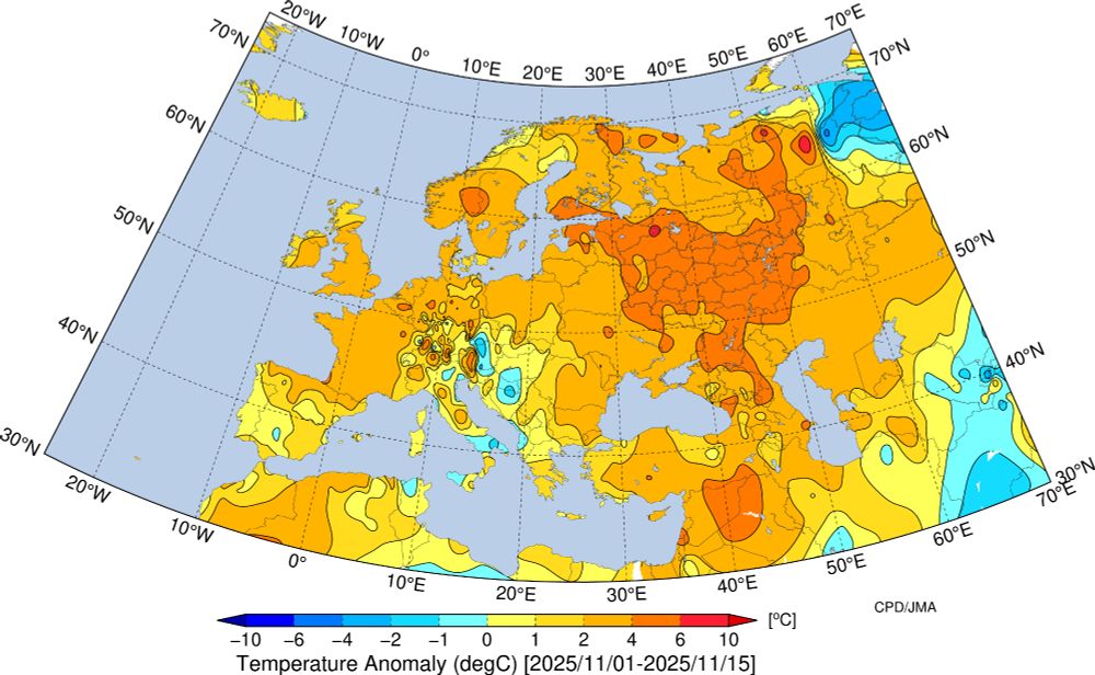
November 2025 will end in Europe with temperatures again significantly above the 1981–2010 climatological reference period.
In the Alps, the marked anomalies of both very warm and very cold spells are expected to balance out, particularly when compared to the more recent 1991–2020 reference period
In the Alps, the marked anomalies of both very warm and very cold spells are expected to balance out, particularly when compared to the more recent 1991–2020 reference period

November 25, 2025 at 9:40 AM
November 2025 will end in Europe with temperatures again significantly above the 1981–2010 climatological reference period.
In the Alps, the marked anomalies of both very warm and very cold spells are expected to balance out, particularly when compared to the more recent 1991–2020 reference period
In the Alps, the marked anomalies of both very warm and very cold spells are expected to balance out, particularly when compared to the more recent 1991–2020 reference period
The recent onset of winter has resulted in above-average snowfall across Switzerland for late November; however, conditions are expected to change at the beginning of December.

November 24, 2025 at 2:28 PM
The recent onset of winter has resulted in above-average snowfall across Switzerland for late November; however, conditions are expected to change at the beginning of December.
impressive WAA (warm air advection) today Sunday: cold air pool Sägistalsee (Bernese Oberland, 1937m): from -36.8 to +2.5 deg C 😮

November 23, 2025 at 6:32 PM
impressive WAA (warm air advection) today Sunday: cold air pool Sägistalsee (Bernese Oberland, 1937m): from -36.8 to +2.5 deg C 😮
Last night brought widespread frost, locally record lows, lower lows than last winter and alpine cold-air pools with –36.8°C surpassing temperatures in northern Norway!
Forecasts indicate a thaw on Monday, with milder conditions persisting until Christmas (Zurich ensemble) 😲
Forecasts indicate a thaw on Monday, with milder conditions persisting until Christmas (Zurich ensemble) 😲


November 23, 2025 at 7:40 AM
Last night brought widespread frost, locally record lows, lower lows than last winter and alpine cold-air pools with –36.8°C surpassing temperatures in northern Norway!
Forecasts indicate a thaw on Monday, with milder conditions persisting until Christmas (Zurich ensemble) 😲
Forecasts indicate a thaw on Monday, with milder conditions persisting until Christmas (Zurich ensemble) 😲
Following >50 cm of fresh snow locally over the past three days (@slfdavos.bsky.social), today in the Swiss Alps sunny weather with wintry snow cover (blue-tinted).
Low stratus over the lowlands, neatly streaked by northeasterly winds.
Low stratus over the lowlands, neatly streaked by northeasterly winds.


November 22, 2025 at 12:06 PM
Following >50 cm of fresh snow locally over the past three days (@slfdavos.bsky.social), today in the Swiss Alps sunny weather with wintry snow cover (blue-tinted).
Low stratus over the lowlands, neatly streaked by northeasterly winds.
Low stratus over the lowlands, neatly streaked by northeasterly winds.
Thick smog over India and Kashmir valley, fog/low stratus in the valleys of Nepal ... as seen by Terra/MODIS on Saturday noon.

November 22, 2025 at 11:26 AM
Thick smog over India and Kashmir valley, fog/low stratus in the valleys of Nepal ... as seen by Terra/MODIS on Saturday noon.
Arctic air from Greenland, fresh snow, and clear Saturday-night: perfect recipe for severe cold across Central Europe by Sunday morning.
Only southern Alpine lakes remained frost-free; some alpine valleys may reach –30°C!
A thaw is already expected next week...
Only southern Alpine lakes remained frost-free; some alpine valleys may reach –30°C!
A thaw is already expected next week...


November 21, 2025 at 8:43 AM
Arctic air from Greenland, fresh snow, and clear Saturday-night: perfect recipe for severe cold across Central Europe by Sunday morning.
Only southern Alpine lakes remained frost-free; some alpine valleys may reach –30°C!
A thaw is already expected next week...
Only southern Alpine lakes remained frost-free; some alpine valleys may reach –30°C!
A thaw is already expected next week...
Recent SSTAs (sea surface temperature anomalies) clearly indicate La Niña in the tropical Pacific, expected to persist until the end of winter.
This has little direct impact on our winter weather; instead, the seas around Europe—currently much warmer than average—play a more significant role
This has little direct impact on our winter weather; instead, the seas around Europe—currently much warmer than average—play a more significant role

November 18, 2025 at 5:53 PM
Recent SSTAs (sea surface temperature anomalies) clearly indicate La Niña in the tropical Pacific, expected to persist until the end of winter.
This has little direct impact on our winter weather; instead, the seas around Europe—currently much warmer than average—play a more significant role
This has little direct impact on our winter weather; instead, the seas around Europe—currently much warmer than average—play a more significant role
Arctic air surging from Greenland brought last night the lowest temperatures in the High Alps since early March: Capanna Margherita near Monte Rosa recorded –21.9°C.
First fresh snow (coloured blue) down to ~700 m in eastern Switzerland and southern Germany.
First fresh snow (coloured blue) down to ~700 m in eastern Switzerland and southern Germany.


November 18, 2025 at 10:50 AM
Arctic air surging from Greenland brought last night the lowest temperatures in the High Alps since early March: Capanna Margherita near Monte Rosa recorded –21.9°C.
First fresh snow (coloured blue) down to ~700 m in eastern Switzerland and southern Germany.
First fresh snow (coloured blue) down to ~700 m in eastern Switzerland and southern Germany.
Record warmth still over southern Europe/northern Africa↙️ ... but in 150 hours with arctic air from Greenland follows record cold ↘️


November 16, 2025 at 10:27 AM
Record warmth still over southern Europe/northern Africa↙️ ... but in 150 hours with arctic air from Greenland follows record cold ↘️
First half of November 2025 was in Europe mostly too warm.
In Switzerland about +1 (south) to +5 (mountains) degrees warmer than usual - now followed by a colder second half.
In Switzerland about +1 (south) to +5 (mountains) degrees warmer than usual - now followed by a colder second half.
November 16, 2025 at 8:32 AM
First half of November 2025 was in Europe mostly too warm.
In Switzerland about +1 (south) to +5 (mountains) degrees warmer than usual - now followed by a colder second half.
In Switzerland about +1 (south) to +5 (mountains) degrees warmer than usual - now followed by a colder second half.
Strong southerly foehn (gusts to 107 km/h) again yields anomalously warm conditions north of the Alps for this season.
However, textbook description of a warm wind with good visibility does not hold today: Saharan dust at ~3 km altitude reduces visibility!
saentis.roundshot.com#/compare/195...
However, textbook description of a warm wind with good visibility does not hold today: Saharan dust at ~3 km altitude reduces visibility!
saentis.roundshot.com#/compare/195...

November 14, 2025 at 11:38 AM
Strong southerly foehn (gusts to 107 km/h) again yields anomalously warm conditions north of the Alps for this season.
However, textbook description of a warm wind with good visibility does not hold today: Saharan dust at ~3 km altitude reduces visibility!
saentis.roundshot.com#/compare/195...
However, textbook description of a warm wind with good visibility does not hold today: Saharan dust at ~3 km altitude reduces visibility!
saentis.roundshot.com#/compare/195...
This dust pocket developed yesterday afternoon in north-western Algeria and is currently at an approximate altitude of 2–3 km (Ceilometer, Menorca).

November 13, 2025 at 11:58 AM
This dust pocket developed yesterday afternoon in north-western Algeria and is currently at an approximate altitude of 2–3 km (Ceilometer, Menorca).
Despite the impressively cold conditions anticipated across Central Europe next week: all available models indicate that the winter of 2025/2026 (1 December to 28 February) is expected to be overall warmer than average.


November 13, 2025 at 10:28 AM
Despite the impressively cold conditions anticipated across Central Europe next week: all available models indicate that the winter of 2025/2026 (1 December to 28 February) is expected to be overall warmer than average.
Despite a robust boundary-layer inversion exceeding 10K, fog was notably absent this morning over the Swiss Plateau. Persistent dense high cloud cover remained, while MTG imagery revealed dense Saharan dust-cloud near the Balearics—most accurately depicted by the Monarch and Met Office UM models.


November 13, 2025 at 8:32 AM
Despite a robust boundary-layer inversion exceeding 10K, fog was notably absent this morning over the Swiss Plateau. Persistent dense high cloud cover remained, while MTG imagery revealed dense Saharan dust-cloud near the Balearics—most accurately depicted by the Monarch and Met Office UM models.
Beneath dense, yet transparent cirrus clouds at high altitude (10–12 km, as recorded by the Payerne ceilometer), persistent fog blanketed the Swiss Plateau until midday. This was capped by a pronounced temperature inversion (10 K) and, notably, remained confined to the Lake Constance basin.


November 12, 2025 at 11:57 AM
Beneath dense, yet transparent cirrus clouds at high altitude (10–12 km, as recorded by the Payerne ceilometer), persistent fog blanketed the Swiss Plateau until midday. This was capped by a pronounced temperature inversion (10 K) and, notably, remained confined to the Lake Constance basin.
Polar light, aurora last night seen from below (eastern Switzerland, starting 02 UTC) and from above (SNPP, day/night band).


November 12, 2025 at 7:15 AM
Polar light, aurora last night seen from below (eastern Switzerland, starting 02 UTC) and from above (SNPP, day/night band).
Snow cover in the Swiss Alps remains around average, but with record warmth expected over the next few days — a freezing level rising to around 3,500 m — it is likely to decrease significantly.
Beyond that, however, there is considerable uncertainty (according to the GFS ensemble) 🤔
Beyond that, however, there is considerable uncertainty (according to the GFS ensemble) 🤔


November 10, 2025 at 9:16 PM
Snow cover in the Swiss Alps remains around average, but with record warmth expected over the next few days — a freezing level rising to around 3,500 m — it is likely to decrease significantly.
Beyond that, however, there is considerable uncertainty (according to the GFS ensemble) 🤔
Beyond that, however, there is considerable uncertainty (according to the GFS ensemble) 🤔
A midday Terra/MODIS (NASA) satellite image from Saturday reveals cloudless, snow-covered (blue-tinted) Alpine region, with fog/low stratus blanketing adjacent lowland plateau between Lake of Geneva and Constance and with a top of 700-800m partially inundating prealpine valleys.

November 8, 2025 at 1:35 PM
A midday Terra/MODIS (NASA) satellite image from Saturday reveals cloudless, snow-covered (blue-tinted) Alpine region, with fog/low stratus blanketing adjacent lowland plateau between Lake of Geneva and Constance and with a top of 700-800m partially inundating prealpine valleys.
For the calendar year 2025 to date (January–October), global temperatures rank as the second warmest in the ERA5 record (since 1940), with Europe experiencing its third warmest such period.


November 8, 2025 at 9:45 AM
For the calendar year 2025 to date (January–October), global temperatures rank as the second warmest in the ERA5 record (since 1940), with Europe experiencing its third warmest such period.
Typical autumnal satellite imagery with fog over the Swiss Plateau. An atypical anticyclonic southerly föhn is sweeping across the Alps: no clouds to the south, yet amid small pressure difference gusts of 60 (Hasli Valley) to 106 km/h and temperatures of 20°C in Elm+Brig - beneath the fog just 4°C


November 6, 2025 at 12:30 PM
Typical autumnal satellite imagery with fog over the Swiss Plateau. An atypical anticyclonic southerly föhn is sweeping across the Alps: no clouds to the south, yet amid small pressure difference gusts of 60 (Hasli Valley) to 106 km/h and temperatures of 20°C in Elm+Brig - beneath the fog just 4°C
October 2025 was globally 3rd warmest since 1940.
Kudos to @climatologist49.bsky.social
Kudos to @climatologist49.bsky.social


November 5, 2025 at 5:22 AM
October 2025 was globally 3rd warmest since 1940.
Kudos to @climatologist49.bsky.social
Kudos to @climatologist49.bsky.social
Settled, dry, and often fine autumnal weather prevails across central Europe.
Meanwhile, a record-breaking extratropical cyclone—termed a “weather bomb”—has intensified near Newfoundland, with a minimum central pressure of 943 hPa recorded on Wednesday morning.
Meanwhile, a record-breaking extratropical cyclone—termed a “weather bomb”—has intensified near Newfoundland, with a minimum central pressure of 943 hPa recorded on Wednesday morning.


November 4, 2025 at 4:08 PM
Settled, dry, and often fine autumnal weather prevails across central Europe.
Meanwhile, a record-breaking extratropical cyclone—termed a “weather bomb”—has intensified near Newfoundland, with a minimum central pressure of 943 hPa recorded on Wednesday morning.
Meanwhile, a record-breaking extratropical cyclone—termed a “weather bomb”—has intensified near Newfoundland, with a minimum central pressure of 943 hPa recorded on Wednesday morning.