

Jack Sapoch
@jacksapoch.bsky.social
Borders, osint, & digital investigations / investigations @lighthousereports.com , sometimes more
The TikTok outlines that a specific goal of these animations is to multiply their reach by cultivating secondary coverage
And indeed, dozens of major outlets like BBC, CNN and Sky News have aired them, in part or in full, often without context
And indeed, dozens of major outlets like BBC, CNN and Sky News have aired them, in part or in full, often without context
October 8, 2025 at 4:58 PM
The TikTok outlines that a specific goal of these animations is to multiply their reach by cultivating secondary coverage
And indeed, dozens of major outlets like BBC, CNN and Sky News have aired them, in part or in full, often without context
And indeed, dozens of major outlets like BBC, CNN and Sky News have aired them, in part or in full, often without context
These videos are produced in-house by a small animation cell in the IDF Spokesperson’s Unit, working mainly in After Effects + Blender
In a TikTok posted after Israel's June attacks on Iran, soldiers describe working weeks under “prime-minister-level secrecy” to prepare visuals
In a TikTok posted after Israel's June attacks on Iran, soldiers describe working weeks under “prime-minister-level secrecy” to prepare visuals
October 8, 2025 at 4:58 PM
These videos are produced in-house by a small animation cell in the IDF Spokesperson’s Unit, working mainly in After Effects + Blender
In a TikTok posted after Israel's June attacks on Iran, soldiers describe working weeks under “prime-minister-level secrecy” to prepare visuals
In a TikTok posted after Israel's June attacks on Iran, soldiers describe working weeks under “prime-minister-level secrecy” to prepare visuals
One of the earlier and most-viewed examples was an animation of Al Shifa Hospital, published in October 2023.
The “underground command room” was recycled from a 2022 IDF animation of an UNRWA school in Tel Al-Hawa; the street above was built from prefab @kb-3d.bsky.social storefronts
The “underground command room” was recycled from a 2022 IDF animation of an UNRWA school in Tel Al-Hawa; the street above was built from prefab @kb-3d.bsky.social storefronts
October 8, 2025 at 4:58 PM
One of the earlier and most-viewed examples was an animation of Al Shifa Hospital, published in October 2023.
The “underground command room” was recycled from a 2022 IDF animation of an UNRWA school in Tel Al-Hawa; the street above was built from prefab @kb-3d.bsky.social storefronts
The “underground command room” was recycled from a 2022 IDF animation of an UNRWA school in Tel Al-Hawa; the street above was built from prefab @kb-3d.bsky.social storefronts
These assets have been used in IDF videos as recently as September 5, in an animation of the Mushtaha Tower in Gaza City, which was destroyed by Israeli airstrikes the same day
In this video the ground itself is a patch-work quilt of third-party scans of pavement & parking lots
In this video the ground itself is a patch-work quilt of third-party scans of pavement & parking lots
October 8, 2025 at 4:58 PM
These assets have been used in IDF videos as recently as September 5, in an animation of the Mushtaha Tower in Gaza City, which was destroyed by Israeli airstrikes the same day
In this video the ground itself is a patch-work quilt of third-party scans of pavement & parking lots
In this video the ground itself is a patch-work quilt of third-party scans of pavement & parking lots
Others assets came from scans made by the Scottish Maritime Museum of their boat-building workshop which was downloaded (via @sketchfab.bsky.social) and reimagined by the IDF adornments for underground missile factories.
October 8, 2025 at 4:58 PM
Others assets came from scans made by the Scottish Maritime Museum of their boat-building workshop which was downloaded (via @sketchfab.bsky.social) and reimagined by the IDF adornments for underground missile factories.
We traced over 30 unique assets to Washington-based 3D creator Ian Hubert, who makes bespoke models created for his sci-fi project Dynamo Dream, available to his Patreon subscribers.
Scans of parking lots, antennas, and pipes were repurposed as Hamas and Iranian military sites
Scans of parking lots, antennas, and pipes were repurposed as Hamas and Iranian military sites
October 8, 2025 at 4:58 PM
We traced over 30 unique assets to Washington-based 3D creator Ian Hubert, who makes bespoke models created for his sci-fi project Dynamo Dream, available to his Patreon subscribers.
Scans of parking lots, antennas, and pipes were repurposed as Hamas and Iranian military sites
Scans of parking lots, antennas, and pipes were repurposed as Hamas and Iranian military sites
Many of these “illustrations” aren’t based on verified intelligence at all.
Our analysis of 43 official IDF videos found recycled 3D environments, spatial inaccuracies, and assets lifted from unrelated artists and institutions.
Our analysis of 43 official IDF videos found recycled 3D environments, spatial inaccuracies, and assets lifted from unrelated artists and institutions.
October 8, 2025 at 4:58 PM
Many of these “illustrations” aren’t based on verified intelligence at all.
Our analysis of 43 official IDF videos found recycled 3D environments, spatial inaccuracies, and assets lifted from unrelated artists and institutions.
Our analysis of 43 official IDF videos found recycled 3D environments, spatial inaccuracies, and assets lifted from unrelated artists and institutions.
NEW: Since October 2023, the IDF Spokesperson's Unit has released dozens of 3D animations illustrating alleged Hamas, Hezbollah, and Iranian sites
The style is now unmistakable: satellite zoom-ins, black & white wireframes, and red-textured houses - a new visual language of war
The style is now unmistakable: satellite zoom-ins, black & white wireframes, and red-textured houses - a new visual language of war
October 8, 2025 at 4:58 PM
NEW: Since October 2023, the IDF Spokesperson's Unit has released dozens of 3D animations illustrating alleged Hamas, Hezbollah, and Iranian sites
The style is now unmistakable: satellite zoom-ins, black & white wireframes, and red-textured houses - a new visual language of war
The style is now unmistakable: satellite zoom-ins, black & white wireframes, and red-textured houses - a new visual language of war
What’s the target, brother?
July 24, 2025 at 5:53 PM
What’s the target, brother?
An impressive case study in the use of photogrammetry and satellite imagery to shed light on the logistics and procedures behind large scale atrocities (in this case in Assad's Syria)
July 11, 2025 at 3:46 PM
An impressive case study in the use of photogrammetry and satellite imagery to shed light on the logistics and procedures behind large scale atrocities (in this case in Assad's Syria)
Tidal changes over a 6 hour period in Rockport, Maine
Video scraped today from a public municipal webcam, and played back at 500,00% speed
Video scraped today from a public municipal webcam, and played back at 500,00% speed
June 26, 2025 at 10:07 PM
Tidal changes over a 6 hour period in Rockport, Maine
Video scraped today from a public municipal webcam, and played back at 500,00% speed
Video scraped today from a public municipal webcam, and played back at 500,00% speed
The old updates are still accessible though via a a live KML network link which is possible to scrape
They are shown here via a time series animation, built w/ scripting in QGIS + AE
They are shown here via a time series animation, built w/ scripting in QGIS + AE
June 11, 2025 at 2:11 PM
The old updates are still accessible though via a a live KML network link which is possible to scrape
They are shown here via a time series animation, built w/ scripting in QGIS + AE
They are shown here via a time series animation, built w/ scripting in QGIS + AE
Each shape shows the extent of an area where new imagery was added
These updates used to be shared publicly until support was removed
These updates used to be shared publicly until support was removed
June 11, 2025 at 2:11 PM
Each shape shows the extent of an area where new imagery was added
These updates used to be shared publicly until support was removed
These updates used to be shared publicly until support was removed
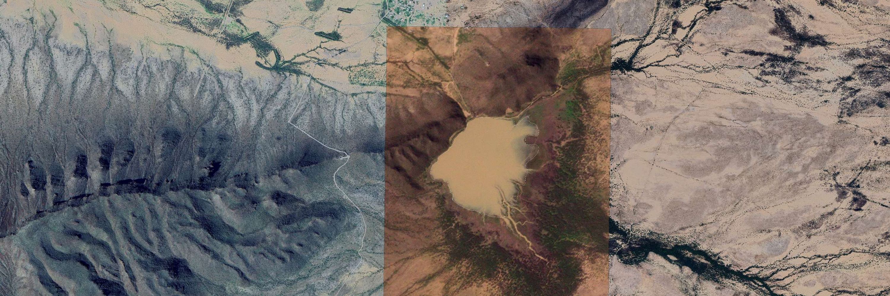
Google Earth (originally released as Keyhole EarthViewer) turns 24 today!
To mark it, I visualized 17,000+ imagery update footprints that were added to Google Earth b/w 2009 - 2014.
To mark it, I visualized 17,000+ imagery update footprints that were added to Google Earth b/w 2009 - 2014.
June 11, 2025 at 2:11 PM
Google Earth (originally released as Keyhole EarthViewer) turns 24 today!
To mark it, I visualized 17,000+ imagery update footprints that were added to Google Earth b/w 2009 - 2014.
To mark it, I visualized 17,000+ imagery update footprints that were added to Google Earth b/w 2009 - 2014.