


@ircarmichael.bsky.social
NO DMs. Just an old Blue Boomer making her way through the world. Happily married. I post about the weather, sports, and anything that interests me. Crazy Cat Lady. Cleveland sports fan. Graduate from The Ohio State University. Do Not Obey In Advance.
NOAA NWS Weather Prediction Center
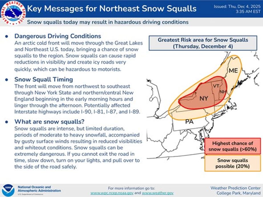
An arctic front tracking across the NE will trigger rounds of snow showers/snow squalls today. Here are the latest Key Messages & an infographic on snow squalls. If you receive a warning, know that a snow squall is occurring or imminent. Slow down or delay travel.
An arctic front tracking across the NE will trigger rounds of snow showers/snow squalls today. Here are the latest Key Messages & an infographic on snow squalls. If you receive a warning, know that a snow squall is occurring or imminent. Slow down or delay travel.

December 4, 2025 at 1:56 PM
NOAA NWS Weather Prediction Center
An arctic front tracking across the NE will trigger rounds of snow showers/snow squalls today. Here are the latest Key Messages & an infographic on snow squalls. If you receive a warning, know that a snow squall is occurring or imminent. Slow down or delay travel.
An arctic front tracking across the NE will trigger rounds of snow showers/snow squalls today. Here are the latest Key Messages & an infographic on snow squalls. If you receive a warning, know that a snow squall is occurring or imminent. Slow down or delay travel.
NOAA NWS Weather Prediction Center
WPC has initiated Key Messages due to the potential for snow squalls along a strong arctic cold front tomorrow (Thursday). Snow squalls can result in a rapid drop in visibility and create icy roads very quickly, which can be hazardous to motorists. ❄️
WPC has initiated Key Messages due to the potential for snow squalls along a strong arctic cold front tomorrow (Thursday). Snow squalls can result in a rapid drop in visibility and create icy roads very quickly, which can be hazardous to motorists. ❄️

December 4, 2025 at 2:22 AM
NOAA NWS Weather Prediction Center
WPC has initiated Key Messages due to the potential for snow squalls along a strong arctic cold front tomorrow (Thursday). Snow squalls can result in a rapid drop in visibility and create icy roads very quickly, which can be hazardous to motorists. ❄️
WPC has initiated Key Messages due to the potential for snow squalls along a strong arctic cold front tomorrow (Thursday). Snow squalls can result in a rapid drop in visibility and create icy roads very quickly, which can be hazardous to motorists. ❄️
NOAA NWS Weather Prediction Center
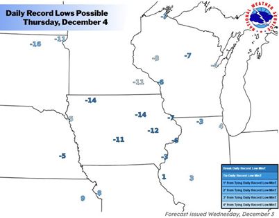
Record cold possible over the next few days across the Midwest, Ohio Valley, Mid-Atlantic. Lows forecast to drop below zero across parts of the Midwest tomorrow morning. Dress appropriately to avoid the risk of frostbite/hypothermia & limit time outdoors.
Record cold possible over the next few days across the Midwest, Ohio Valley, Mid-Atlantic. Lows forecast to drop below zero across parts of the Midwest tomorrow morning. Dress appropriately to avoid the risk of frostbite/hypothermia & limit time outdoors.

December 4, 2025 at 2:18 AM
NOAA NWS Weather Prediction Center
Record cold possible over the next few days across the Midwest, Ohio Valley, Mid-Atlantic. Lows forecast to drop below zero across parts of the Midwest tomorrow morning. Dress appropriately to avoid the risk of frostbite/hypothermia & limit time outdoors.
Record cold possible over the next few days across the Midwest, Ohio Valley, Mid-Atlantic. Lows forecast to drop below zero across parts of the Midwest tomorrow morning. Dress appropriately to avoid the risk of frostbite/hypothermia & limit time outdoors.
Coastal N New England
Moderate/heavy snow rates around 1/2-1+"/hr possible this evening, with heaviest rates near Down East coastal areas closer to/after Midnight EST, as strengthening/gusty winds contribute to reduced visibilities, blowing/drifting. #mewx #nhwx
www.spc.noaa.gov/products/md/...
Moderate/heavy snow rates around 1/2-1+"/hr possible this evening, with heaviest rates near Down East coastal areas closer to/after Midnight EST, as strengthening/gusty winds contribute to reduced visibilities, blowing/drifting. #mewx #nhwx
www.spc.noaa.gov/products/md/...

December 3, 2025 at 2:55 AM
Coastal N New England
Moderate/heavy snow rates around 1/2-1+"/hr possible this evening, with heaviest rates near Down East coastal areas closer to/after Midnight EST, as strengthening/gusty winds contribute to reduced visibilities, blowing/drifting. #mewx #nhwx
www.spc.noaa.gov/products/md/...
Moderate/heavy snow rates around 1/2-1+"/hr possible this evening, with heaviest rates near Down East coastal areas closer to/after Midnight EST, as strengthening/gusty winds contribute to reduced visibilities, blowing/drifting. #mewx #nhwx
www.spc.noaa.gov/products/md/...

Eastern Pennsylvania into Southern New York, Western Massachusetts, Western Connecticut
A combination of freezing rain, sleet, heavy snow will persist this morning and into the early afternoon across portions of the Northeast #mawx #ctwx #vtwx #nywx #njwx #pawx #mdwx
www.spc.noaa.gov/products/md/...
A combination of freezing rain, sleet, heavy snow will persist this morning and into the early afternoon across portions of the Northeast #mawx #ctwx #vtwx #nywx #njwx #pawx #mdwx
www.spc.noaa.gov/products/md/...

December 2, 2025 at 3:13 PM
W/N Kentucky, Adjacent Portions of the Ohio Valley
A narrow developing corridor of heavy snow rates around or in excess of 1 in/hr appears possible, spreading across western through northern Kentucky between Midnight-4 AM EST (11 PM-3 AM CST). #ohwx #kywx #inwx #tnwx
www.spc.noaa.gov/products/md/...
A narrow developing corridor of heavy snow rates around or in excess of 1 in/hr appears possible, spreading across western through northern Kentucky between Midnight-4 AM EST (11 PM-3 AM CST). #ohwx #kywx #inwx #tnwx
www.spc.noaa.gov/products/md/...

December 2, 2025 at 4:02 AM
W/N Kentucky, Adjacent Portions of the Ohio Valley
A narrow developing corridor of heavy snow rates around or in excess of 1 in/hr appears possible, spreading across western through northern Kentucky between Midnight-4 AM EST (11 PM-3 AM CST). #ohwx #kywx #inwx #tnwx
www.spc.noaa.gov/products/md/...
A narrow developing corridor of heavy snow rates around or in excess of 1 in/hr appears possible, spreading across western through northern Kentucky between Midnight-4 AM EST (11 PM-3 AM CST). #ohwx #kywx #inwx #tnwx
www.spc.noaa.gov/products/md/...
Portions of the Central Gulf Coast
A combination of cell training and backbuilding should continue to lead to hourly rain amounts to 1.75" with local totals to 4", which could cause flash flooding in urban areas. #alwx #flwx #mswx #lawx
www.wpc.ncep.noaa.gov/metwatch/met...
A combination of cell training and backbuilding should continue to lead to hourly rain amounts to 1.75" with local totals to 4", which could cause flash flooding in urban areas. #alwx #flwx #mswx #lawx
www.wpc.ncep.noaa.gov/metwatch/met...

December 2, 2025 at 2:29 AM
Portions of the Central Gulf Coast
A combination of cell training and backbuilding should continue to lead to hourly rain amounts to 1.75" with local totals to 4", which could cause flash flooding in urban areas. #alwx #flwx #mswx #lawx
www.wpc.ncep.noaa.gov/metwatch/met...
A combination of cell training and backbuilding should continue to lead to hourly rain amounts to 1.75" with local totals to 4", which could cause flash flooding in urban areas. #alwx #flwx #mswx #lawx
www.wpc.ncep.noaa.gov/metwatch/met...
NOAA NWS Weather Prediction Center
Widespread hazardous travel is likely tonight & through Tuesday night as a winter storm produces disruptive snow & ice from the Central Appalachians to the Northeast. For the latest forecast information, please visit weather.gov
Widespread hazardous travel is likely tonight & through Tuesday night as a winter storm produces disruptive snow & ice from the Central Appalachians to the Northeast. For the latest forecast information, please visit weather.gov

December 1, 2025 at 11:09 PM
NOAA NWS Weather Prediction Center
Widespread hazardous travel is likely tonight & through Tuesday night as a winter storm produces disruptive snow & ice from the Central Appalachians to the Northeast. For the latest forecast information, please visit weather.gov
Widespread hazardous travel is likely tonight & through Tuesday night as a winter storm produces disruptive snow & ice from the Central Appalachians to the Northeast. For the latest forecast information, please visit weather.gov
NOAA NWS Weather Prediction Center
Widespread hazardous travel is likely Mon night through Tue night due to snow & ice, especially during Tue commutes. Heavy snow (5-10+") in the Northeast; significant icing (0.1-0.2") in the Appalachians. Stay safe & check weather.gov
Widespread hazardous travel is likely Mon night through Tue night due to snow & ice, especially during Tue commutes. Heavy snow (5-10+") in the Northeast; significant icing (0.1-0.2") in the Appalachians. Stay safe & check weather.gov

December 1, 2025 at 1:47 PM
NOAA NWS Weather Prediction Center
Widespread hazardous travel is likely Mon night through Tue night due to snow & ice, especially during Tue commutes. Heavy snow (5-10+") in the Northeast; significant icing (0.1-0.2") in the Appalachians. Stay safe & check weather.gov
Widespread hazardous travel is likely Mon night through Tue night due to snow & ice, especially during Tue commutes. Heavy snow (5-10+") in the Northeast; significant icing (0.1-0.2") in the Appalachians. Stay safe & check weather.gov
NE Oklahoma, Western/Central Arkansas, Far SW Missouri
Freezing rain may increase across parts of central Arkansas this morning, while light mixed precipitation will continue to spread from NE Oklahoma into NW Arkansas and Far SW Missouri. #arwx #mowx #okwx
www.spc.noaa.gov/products/md/...
Freezing rain may increase across parts of central Arkansas this morning, while light mixed precipitation will continue to spread from NE Oklahoma into NW Arkansas and Far SW Missouri. #arwx #mowx #okwx
www.spc.noaa.gov/products/md/...

December 1, 2025 at 1:42 PM
NE Oklahoma, Western/Central Arkansas, Far SW Missouri
Freezing rain may increase across parts of central Arkansas this morning, while light mixed precipitation will continue to spread from NE Oklahoma into NW Arkansas and Far SW Missouri. #arwx #mowx #okwx
www.spc.noaa.gov/products/md/...
Freezing rain may increase across parts of central Arkansas this morning, while light mixed precipitation will continue to spread from NE Oklahoma into NW Arkansas and Far SW Missouri. #arwx #mowx #okwx
www.spc.noaa.gov/products/md/...
This is the last regularly scheduled Tropical Weather Outlook of the 2025 Atlantic Hurricane Season. Routine issuance of the Tropical Weather Outlook will resume on May 15, 2026.
www.nhc.noaa.gov/text/refresh...
www.nhc.noaa.gov/text/refresh...

December 1, 2025 at 1:23 AM
This is the last regularly scheduled Tropical Weather Outlook of the 2025 Atlantic Hurricane Season. Routine issuance of the Tropical Weather Outlook will resume on May 15, 2026.
www.nhc.noaa.gov/text/refresh...
www.nhc.noaa.gov/text/refresh...
NOAA NWS Weather Prediction Center
A winter storm will approach the Mid Atlantic and Northeast beginning Monday evening with a threat of snow/ice across the interior portions of both regions. Any snowfall and ice will present hazardous travel concerns, especially across the interior Northeast U.S.
A winter storm will approach the Mid Atlantic and Northeast beginning Monday evening with a threat of snow/ice across the interior portions of both regions. Any snowfall and ice will present hazardous travel concerns, especially across the interior Northeast U.S.

November 30, 2025 at 8:52 PM
NOAA NWS Weather Prediction Center
A winter storm will approach the Mid Atlantic and Northeast beginning Monday evening with a threat of snow/ice across the interior portions of both regions. Any snowfall and ice will present hazardous travel concerns, especially across the interior Northeast U.S.
A winter storm will approach the Mid Atlantic and Northeast beginning Monday evening with a threat of snow/ice across the interior portions of both regions. Any snowfall and ice will present hazardous travel concerns, especially across the interior Northeast U.S.
NOAA NWS Weather Prediction Center
Winter Storm likely next week: Hazardous travel, snow, & ice expected. Low pressure tracking through the Mid-Atlantic & Northeast may bring significant snow of >6" N/W of I-95. Treacherous icing possible in the Appalachians. Stay updated!
Winter Storm likely next week: Hazardous travel, snow, & ice expected. Low pressure tracking through the Mid-Atlantic & Northeast may bring significant snow of >6" N/W of I-95. Treacherous icing possible in the Appalachians. Stay updated!

November 30, 2025 at 4:48 PM
NOAA NWS Weather Prediction Center
Winter Storm likely next week: Hazardous travel, snow, & ice expected. Low pressure tracking through the Mid-Atlantic & Northeast may bring significant snow of >6" N/W of I-95. Treacherous icing possible in the Appalachians. Stay updated!
Winter Storm likely next week: Hazardous travel, snow, & ice expected. Low pressure tracking through the Mid-Atlantic & Northeast may bring significant snow of >6" N/W of I-95. Treacherous icing possible in the Appalachians. Stay updated!
Central/Upper Texas Coastal Plain
Slow moving, pre-frontal cells with rates of 2"/hr will eventually merge with S-SE pressing cold front convection resulting in 2-4" totals in 1-3 hours. Isolated flash flooding possible, especially near urban centers #lawx #txwx
www.wpc.ncep.noaa.gov/metwatch/met...
Slow moving, pre-frontal cells with rates of 2"/hr will eventually merge with S-SE pressing cold front convection resulting in 2-4" totals in 1-3 hours. Isolated flash flooding possible, especially near urban centers #lawx #txwx
www.wpc.ncep.noaa.gov/metwatch/met...

November 30, 2025 at 4:16 AM
Central/Upper Texas Coastal Plain
Slow moving, pre-frontal cells with rates of 2"/hr will eventually merge with S-SE pressing cold front convection resulting in 2-4" totals in 1-3 hours. Isolated flash flooding possible, especially near urban centers #lawx #txwx
www.wpc.ncep.noaa.gov/metwatch/met...
Slow moving, pre-frontal cells with rates of 2"/hr will eventually merge with S-SE pressing cold front convection resulting in 2-4" totals in 1-3 hours. Isolated flash flooding possible, especially near urban centers #lawx #txwx
www.wpc.ncep.noaa.gov/metwatch/met...
SE Texas
Thunderstorms near Houston TX are expected to grow and potentially backbuild/train with time. Hourly amounts to 2.5" with local totals to 5" could lead to widely scattered instances of flash flooding. #txwx
www.wpc.ncep.noaa.gov/metwatch/met...
Thunderstorms near Houston TX are expected to grow and potentially backbuild/train with time. Hourly amounts to 2.5" with local totals to 5" could lead to widely scattered instances of flash flooding. #txwx
www.wpc.ncep.noaa.gov/metwatch/met...

November 29, 2025 at 10:24 PM
SE Texas
Thunderstorms near Houston TX are expected to grow and potentially backbuild/train with time. Hourly amounts to 2.5" with local totals to 5" could lead to widely scattered instances of flash flooding. #txwx
www.wpc.ncep.noaa.gov/metwatch/met...
Thunderstorms near Houston TX are expected to grow and potentially backbuild/train with time. Hourly amounts to 2.5" with local totals to 5" could lead to widely scattered instances of flash flooding. #txwx
www.wpc.ncep.noaa.gov/metwatch/met...
Central Texas to the Texas Coastal Plain
Thunderstorm development is underway. Thunderstorms are expected to generally remain sub-severe, but a few strong/severe storms are possible. Watch issuance is not expected. #txwx
www.spc.noaa.gov/products/md/...
Thunderstorm development is underway. Thunderstorms are expected to generally remain sub-severe, but a few strong/severe storms are possible. Watch issuance is not expected. #txwx
www.spc.noaa.gov/products/md/...

November 29, 2025 at 9:26 PM
Central Texas to the Texas Coastal Plain
Thunderstorm development is underway. Thunderstorms are expected to generally remain sub-severe, but a few strong/severe storms are possible. Watch issuance is not expected. #txwx
www.spc.noaa.gov/products/md/...
Thunderstorm development is underway. Thunderstorms are expected to generally remain sub-severe, but a few strong/severe storms are possible. Watch issuance is not expected. #txwx
www.spc.noaa.gov/products/md/...
Parts of the Midwest
Bursts of moderate to heavy snow likely to evolve towards the Michigan/Ohio border this evening. Snowfall rates around 1 in/hr are probable, briefly near 2 in/hr possible, before waning tonight. #ohwx #miwx #inwx #ilwx
www.spc.noaa.gov/products/md/...
Bursts of moderate to heavy snow likely to evolve towards the Michigan/Ohio border this evening. Snowfall rates around 1 in/hr are probable, briefly near 2 in/hr possible, before waning tonight. #ohwx #miwx #inwx #ilwx
www.spc.noaa.gov/products/md/...

November 29, 2025 at 9:13 PM
Parts of the Midwest
Bursts of moderate to heavy snow likely to evolve towards the Michigan/Ohio border this evening. Snowfall rates around 1 in/hr are probable, briefly near 2 in/hr possible, before waning tonight. #ohwx #miwx #inwx #ilwx
www.spc.noaa.gov/products/md/...
Bursts of moderate to heavy snow likely to evolve towards the Michigan/Ohio border this evening. Snowfall rates around 1 in/hr are probable, briefly near 2 in/hr possible, before waning tonight. #ohwx #miwx #inwx #ilwx
www.spc.noaa.gov/products/md/...
Parts of Illinois, SE Iowa, Far NE Missouri
Primary bands of moderate to sporadic heavy snow should pivot from S-Central across SE Iowa, and persist across much of central into N Illinois through this afternoon. Rates around 1"/hr should occur. #ilwx #iawx #mowx
www.spc.noaa.gov/products/md/...
Primary bands of moderate to sporadic heavy snow should pivot from S-Central across SE Iowa, and persist across much of central into N Illinois through this afternoon. Rates around 1"/hr should occur. #ilwx #iawx #mowx
www.spc.noaa.gov/products/md/...

November 29, 2025 at 4:52 PM
Parts of Illinois, SE Iowa, Far NE Missouri
Primary bands of moderate to sporadic heavy snow should pivot from S-Central across SE Iowa, and persist across much of central into N Illinois through this afternoon. Rates around 1"/hr should occur. #ilwx #iawx #mowx
www.spc.noaa.gov/products/md/...
Primary bands of moderate to sporadic heavy snow should pivot from S-Central across SE Iowa, and persist across much of central into N Illinois through this afternoon. Rates around 1"/hr should occur. #ilwx #iawx #mowx
www.spc.noaa.gov/products/md/...
NOAA NWS Weather Prediction Center
The potential for a winter storm early next week is increasing. Widespread impactful snow is possible from the Ohio Valley to the Northeast, with icing in the southern/central Appalachians. Hazardous travel/disruptions are likely. Check weather.gov for the latest.
The potential for a winter storm early next week is increasing. Widespread impactful snow is possible from the Ohio Valley to the Northeast, with icing in the southern/central Appalachians. Hazardous travel/disruptions are likely. Check weather.gov for the latest.

November 29, 2025 at 4:14 PM
NOAA NWS Weather Prediction Center
The potential for a winter storm early next week is increasing. Widespread impactful snow is possible from the Ohio Valley to the Northeast, with icing in the southern/central Appalachians. Hazardous travel/disruptions are likely. Check weather.gov for the latest.
The potential for a winter storm early next week is increasing. Widespread impactful snow is possible from the Ohio Valley to the Northeast, with icing in the southern/central Appalachians. Hazardous travel/disruptions are likely. Check weather.gov for the latest.
NOAA NWS Weather Prediction Center
⚠️ Winter Storm Peaks Today⚠️
Midwest & Great Lakes: Snowfall rates of 1+"/hr possible through tonight. Expect dangerous travel with widespread 6-12" totals and local maxima of over 1 foot.
⚠️ Winter Storm Peaks Today⚠️
Midwest & Great Lakes: Snowfall rates of 1+"/hr possible through tonight. Expect dangerous travel with widespread 6-12" totals and local maxima of over 1 foot.

November 29, 2025 at 4:10 PM
NOAA NWS Weather Prediction Center
⚠️ Winter Storm Peaks Today⚠️
Midwest & Great Lakes: Snowfall rates of 1+"/hr possible through tonight. Expect dangerous travel with widespread 6-12" totals and local maxima of over 1 foot.
⚠️ Winter Storm Peaks Today⚠️
Midwest & Great Lakes: Snowfall rates of 1+"/hr possible through tonight. Expect dangerous travel with widespread 6-12" totals and local maxima of over 1 foot.
Atlantic Hurricane Season Closes Near Normal
The 2025 Atlantic hurricane season was notable for its striking contrast — wavering between periods of relative calm and bursts of intense activity, generating very powerful storms.
www.weathernationtv.com/news/atlanti...
The 2025 Atlantic hurricane season was notable for its striking contrast — wavering between periods of relative calm and bursts of intense activity, generating very powerful storms.
www.weathernationtv.com/news/atlanti...

November 29, 2025 at 3:57 PM
Atlantic Hurricane Season Closes Near Normal
The 2025 Atlantic hurricane season was notable for its striking contrast — wavering between periods of relative calm and bursts of intense activity, generating very powerful storms.
www.weathernationtv.com/news/atlanti...
The 2025 Atlantic hurricane season was notable for its striking contrast — wavering between periods of relative calm and bursts of intense activity, generating very powerful storms.
www.weathernationtv.com/news/atlanti...
E-Central/SE Nebraska into SW/Central Iowa
Snow rates may approach or exceed 1 in/hr at times this morning. #iawx #mowx #newx
www.spc.noaa.gov/products/md/...
Snow rates may approach or exceed 1 in/hr at times this morning. #iawx #mowx #newx
www.spc.noaa.gov/products/md/...

November 29, 2025 at 2:45 PM
E-Central/SE Nebraska into SW/Central Iowa
Snow rates may approach or exceed 1 in/hr at times this morning. #iawx #mowx #newx
www.spc.noaa.gov/products/md/...
Snow rates may approach or exceed 1 in/hr at times this morning. #iawx #mowx #newx
www.spc.noaa.gov/products/md/...
NOAA NWS Weather Prediction Center
Heavy snow/gusty winds will lead to significant travel impacts across portions of the Plains/Midwest beginning this afternoon thru Sunday morning. This will be a major winter storm for many with a large area seeing 6-12+ inches of snow over the next few days.
Heavy snow/gusty winds will lead to significant travel impacts across portions of the Plains/Midwest beginning this afternoon thru Sunday morning. This will be a major winter storm for many with a large area seeing 6-12+ inches of snow over the next few days.

November 28, 2025 at 11:30 PM
NOAA NWS Weather Prediction Center
Heavy snow/gusty winds will lead to significant travel impacts across portions of the Plains/Midwest beginning this afternoon thru Sunday morning. This will be a major winter storm for many with a large area seeing 6-12+ inches of snow over the next few days.
Heavy snow/gusty winds will lead to significant travel impacts across portions of the Plains/Midwest beginning this afternoon thru Sunday morning. This will be a major winter storm for many with a large area seeing 6-12+ inches of snow over the next few days.
NOAA NWS Weather Prediction Center
A significant snowstorm will impact a good portion of the Northern Plains and Midwest starting Friday and carrying through Sunday morning. Several inches of snow will make for dangerous travel conditions, so be sure to plan accordingly as we move into the weekend.
A significant snowstorm will impact a good portion of the Northern Plains and Midwest starting Friday and carrying through Sunday morning. Several inches of snow will make for dangerous travel conditions, so be sure to plan accordingly as we move into the weekend.

November 27, 2025 at 10:51 PM
NOAA NWS Weather Prediction Center
A significant snowstorm will impact a good portion of the Northern Plains and Midwest starting Friday and carrying through Sunday morning. Several inches of snow will make for dangerous travel conditions, so be sure to plan accordingly as we move into the weekend.
A significant snowstorm will impact a good portion of the Northern Plains and Midwest starting Friday and carrying through Sunday morning. Several inches of snow will make for dangerous travel conditions, so be sure to plan accordingly as we move into the weekend.