


Mark Ingalls
@ingalls.mstdn.ca.ap.brid.gy
White Rock, B.C. based meteorologist working in the energy industry. Tooting about weather in and around my region as well as some geology, my thoughts on urban and […]
[bridged from https://mstdn.ca/@ingalls on the fediverse by https://fed.brid.gy/ ]
[bridged from https://mstdn.ca/@ingalls on the fediverse by https://fed.brid.gy/ ]
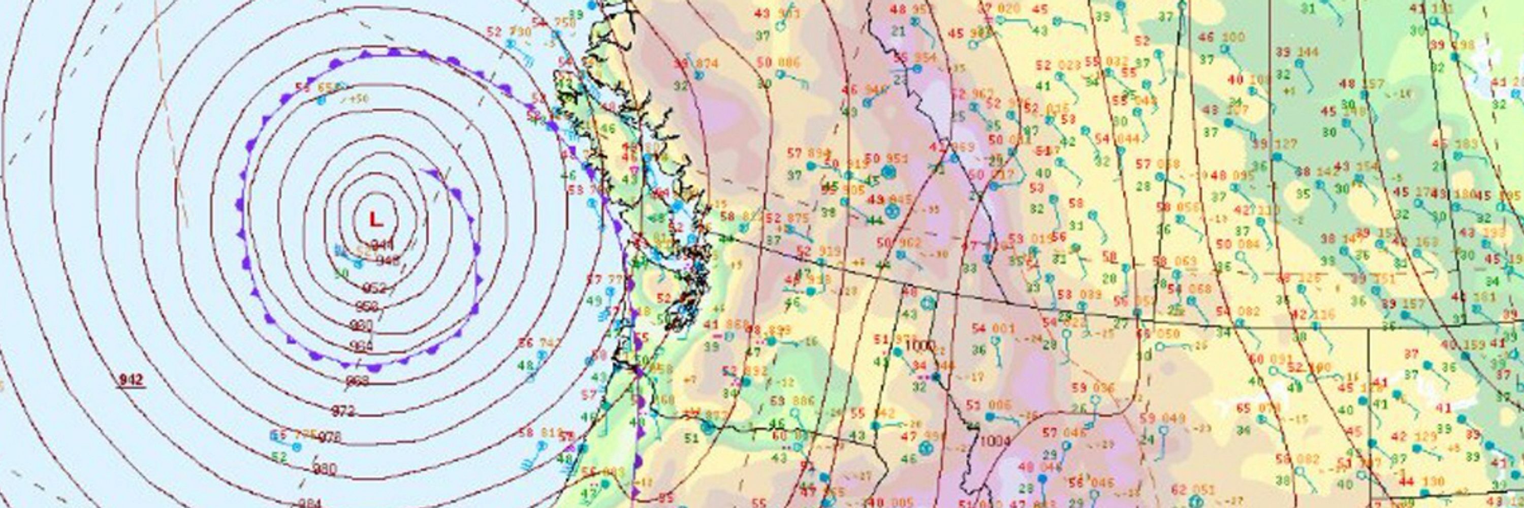
New article: Wet weekend ahead for Pacific Northwest
Also a discussion of why I don't trust the snowpack data from SE British Columbia
https://ingallswx.com/2026/02/05/wet-weekend-ahead-for-pacific-northwest/
#weather #bcstorm #WaWx #OrWx
Also a discussion of why I don't trust the snowpack data from SE British Columbia
https://ingallswx.com/2026/02/05/wet-weekend-ahead-for-pacific-northwest/
#weather #bcstorm #WaWx #OrWx

ingallswx.com
February 5, 2026 at 5:20 PM
New article: Wet weekend ahead for Pacific Northwest
Also a discussion of why I don't trust the snowpack data from SE British Columbia
https://ingallswx.com/2026/02/05/wet-weekend-ahead-for-pacific-northwest/
#weather #bcstorm #WaWx #OrWx
Also a discussion of why I don't trust the snowpack data from SE British Columbia
https://ingallswx.com/2026/02/05/wet-weekend-ahead-for-pacific-northwest/
#weather #bcstorm #WaWx #OrWx

#Vancouver #weather
20260205
Patchy morning fog otherwise mostly sunny with highs around 13. Morning fog, afternoon sun tomorrow but increasing clouds in the evening. Rain Saturday with showers into the beginning of next week. Cooler temps with highs around 8 by Monday.
#yvr #bcstorm
20260205
Patchy morning fog otherwise mostly sunny with highs around 13. Morning fog, afternoon sun tomorrow but increasing clouds in the evening. Rain Saturday with showers into the beginning of next week. Cooler temps with highs around 8 by Monday.
#yvr #bcstorm
February 5, 2026 at 1:05 PM
#Vancouver #weather
20260205
Patchy morning fog otherwise mostly sunny with highs around 13. Morning fog, afternoon sun tomorrow but increasing clouds in the evening. Rain Saturday with showers into the beginning of next week. Cooler temps with highs around 8 by Monday.
#yvr #bcstorm
20260205
Patchy morning fog otherwise mostly sunny with highs around 13. Morning fog, afternoon sun tomorrow but increasing clouds in the evening. Rain Saturday with showers into the beginning of next week. Cooler temps with highs around 8 by Monday.
#yvr #bcstorm
Today in unexpected weather news: Cliff Mass is mentioned in the Epstein files. It's just his blog being sent to Epstein by former Microsoft employee Tren Griffin but still pretty wild.
![4. A question about the economic benefits of universities ... the way to create a great city is to “create a great
university and wait 200 years.” http://andrewgelman.com/2011/03/a_question_abou_10/ [Tren: At the time of
statehood for Washington (1889), Seattle had the University of Washington, Olympia was given the capital,
Walla Walla had the prison, and Pt. Townsend was closer to markets by sea. Tacoma was served by a railroad
first. Bill Gates Senior left Bremerton for Seattle to attend the UW and never left. His son Bill Gates snuck into
the UW to learn more about computers while in high school. Seattle “won” the economic development race
because it had the UW. Full stop. If there is a better real world long term case study for the value of a university
in economic development in a modern economy I'm not aware of it.]
5. Cliff Mass Weather Blog: Will we do anything about global warming? Should we?
http://cliffmass.blogspot.com/2012/02/will-we-do-anything-about-global. html
Cliff Mass discusses the weather we have now in Puget Sound:
http://cliffmass. blogspot.com/2012/02/unusual-ridge-that-wont-go-away.html
6. A proposal to solve High Frequency Trading problems without Tobin taxes:
http://pointsandfigures.com/2012/02/11/speedy-trading-screws-up-the-market/
7. The sheepskin effect http://modeledbehavior.com/2012/02/09/caplan-and-the-sheepskin-effect/](https://cdn.bsky.app/img/feed_thumbnail/plain/did:plc:7gy77jboopy5m4czluevnjso/bafkreihb7jnpunbpwhd6gd3kgx4vcmigkdcou3bl7i5yhscnatmq2jshw4@jpeg)
February 4, 2026 at 8:21 PM
Today in unexpected weather news: Cliff Mass is mentioned in the Epstein files. It's just his blog being sent to Epstein by former Microsoft employee Tren Griffin but still pretty wild.
#Vancouver #weather
20260204
Mixed clouds and sun today with a high near 15. Similar tomorrow but with fewer clouds. Increasing clouds Friday evening with rain Saturday.
#yvr #bcstorm
20260204
Mixed clouds and sun today with a high near 15. Similar tomorrow but with fewer clouds. Increasing clouds Friday evening with rain Saturday.
#yvr #bcstorm
February 4, 2026 at 1:05 PM
#Vancouver #weather
20260204
Mixed clouds and sun today with a high near 15. Similar tomorrow but with fewer clouds. Increasing clouds Friday evening with rain Saturday.
#yvr #bcstorm
20260204
Mixed clouds and sun today with a high near 15. Similar tomorrow but with fewer clouds. Increasing clouds Friday evening with rain Saturday.
#yvr #bcstorm
#Vancouver #weather
20260203
Patchy drizzle and fog with a high around 13. Perhaps some clearing around Surrey and Langley. Mixed sun and clouds tomorrow, mostly sunny Thursday and Friday.
#yvr #bcstorm
20260203
Patchy drizzle and fog with a high around 13. Perhaps some clearing around Surrey and Langley. Mixed sun and clouds tomorrow, mostly sunny Thursday and Friday.
#yvr #bcstorm
February 3, 2026 at 12:54 PM
#Vancouver #weather
20260203
Patchy drizzle and fog with a high around 13. Perhaps some clearing around Surrey and Langley. Mixed sun and clouds tomorrow, mostly sunny Thursday and Friday.
#yvr #bcstorm
20260203
Patchy drizzle and fog with a high around 13. Perhaps some clearing around Surrey and Langley. Mixed sun and clouds tomorrow, mostly sunny Thursday and Friday.
#yvr #bcstorm
Reposted by Mark Ingalls

Really weird to see scans of printed out Wikipedia pages in the Epstein documents, and they’ve redacted names from them, but the URLs and dates are printed in the footer, so you can go look up the pages from those dates and see all the names.
February 2, 2026 at 6:53 PM
Really weird to see scans of printed out Wikipedia pages in the Epstein documents, and they’ve redacted names from them, but the URLs and dates are printed in the footer, so you can go look up the pages from those dates and see all the names.
New article: High pressure to block incoming storms from reaching most of Pacific Northwest
https://ingallswx.com/2026/02/02/high-pressure-to-block-incoming-storms-from-reaching-most-of-pacific-northwest/
#weather #WaWx #OrWx #bcstorm
https://ingallswx.com/2026/02/02/high-pressure-to-block-incoming-storms-from-reaching-most-of-pacific-northwest/
#weather #WaWx #OrWx #bcstorm

## High pressure to block incoming storms from reaching most of Pacific Northwest
Rain showers are forecast for many west side and British Columbia locations on Monday but most people will dry out beginning Tuesday thanks to high pressure rebuilding in the Western United States. The storm track will be aimed at the B.C. North Coast during this period so Bella Coola and Prince Rupert will remain wet.
High pressure onshore is particularly effective at blocking incoming storm systems from reaching the region. We experienced a similar pattern about two weeks ago as high pressure offshore aimed storms at Alaska.
> _Ingalls Weather thanks the support it gets from donors. Please consider making a small donation _at this link _ to help me pay for the website and access to premium weather data._
Temperatures will be warm for many, with Vancouver, B.C. looking at highs close to 12ºC (54ºF) this week under mostly sunny skies. The Columbia Basin seems likely to have the temperature inversion resume, which would keep that region cloudy and cold.
The orientation of the storm track is such that the interior of British Columbia will be dry despite heavy rain along the Coast. Prince George and points south are likely to be rain free but to the north, Dease Lake and the surrounding region will see some snow.
Type your email…
Subscribe
This weather pattern will continue the poor snowpack seen so far in Washington, Oregon, and Southwest British Columbia. Not only will the week be mostly dry, warm temperatures will continue to melt what snow we do have in the mountains. Watering restrictions are already expected in the Lower Mainland this summer.
Yakima River reservoirs actually continue to be healthy for this time of year but this doesn’t tell the whole story. In an average year, water in these reservoirs peaks around early June. If the current pattern continues, we will probably see an earlier peak with water resources scarce by the end of summer.
Mountain snow is important for Yakima Valley agriculture, as it is for other districts that irrigate off smaller rivers like the Walla Walla. Having mountain snow slowly melt into June is like having moderate rainfall every day into the summer months.
Without it, resource managers will have a difficult time maintaining healthy water availability toward the end of the summer and water restrictions will likely be needed. The reservoirs are mostly full right now because of the multiple strong atmospheric rivers that brought rain in December and early January. The water we have now is not from snowfall.
There is a small hint of a possible cold snap/snow event in the Pacific Northwest toward the end of February but there is a lot of uncertainty and, unlike the prospect of the Seahawks winning the Super Bowl, it’s far too early to board the hype train.
There is a sudden stratospheric warming event starting to occur at the North Pole. This can amplify waves in the jet stream which in turn opens up the possibility of pulling very cold Arctic air south into the mid-latitudes. What we don’t know is where exactly this cold will land.
Over the past five days or so, models have offered wildly different solutions. Big Pacific Northwest snow is among these, but so is another major cold snap for the Great Lakes Region, heavy snow for Scandinavia, and deep cold for Siberia. It is something to watch, but we are far from spiking the football on this despite what some social media hype machines would like you to believe.
_The featured image is 500 mb heights for Wednesday showing high pressure near Reno, Nevada which will be blocking storms from reaching the Pacific Northwest._
#Weather #wawx #orwx #BCstorm
ingallswx.com
February 2, 2026 at 1:13 PM
New article: High pressure to block incoming storms from reaching most of Pacific Northwest
https://ingallswx.com/2026/02/02/high-pressure-to-block-incoming-storms-from-reaching-most-of-pacific-northwest/
#weather #WaWx #OrWx #bcstorm
https://ingallswx.com/2026/02/02/high-pressure-to-block-incoming-storms-from-reaching-most-of-pacific-northwest/
#weather #WaWx #OrWx #bcstorm
#Vancouver #weather
20260202
Rain showers today and cloudy tomorrow but high pressure will block other storm systems from reaching the Lower Mainland until maybe Saturday.
#yvr #bcstorm
20260202
Rain showers today and cloudy tomorrow but high pressure will block other storm systems from reaching the Lower Mainland until maybe Saturday.
#yvr #bcstorm
February 2, 2026 at 12:42 PM
#Vancouver #weather
20260202
Rain showers today and cloudy tomorrow but high pressure will block other storm systems from reaching the Lower Mainland until maybe Saturday.
#yvr #bcstorm
20260202
Rain showers today and cloudy tomorrow but high pressure will block other storm systems from reaching the Lower Mainland until maybe Saturday.
#yvr #bcstorm
New article: Extinct volcanoes hiding west of Yakima
https://ingallswx.com/2026/01/28/extinct-volcanoes-hiding-west-of-yakima/
#geology #washington #volcano #yakima
https://ingallswx.com/2026/01/28/extinct-volcanoes-hiding-west-of-yakima/
#geology #washington #volcano #yakima

## Extinct volcanoes hiding west of Yakima
I grew up camping with my family on Clear Lake between Rimrock Lake and White Pass, west of Yakima. If you get up a nearby hill, the Goat Rocks dominate the view to the south. Goat Rocks is the eroded core of an old Cascade volcano being worn down by glaciers and other elements.
At least for me, Goat Rocks is the best example of an extinct Cascade volcano. It is visible in many places along the Highway 12 corridor and the rugged high-altitude profile sets it apart from other nearby large mountains. The Pacific Crest Trail crosses it, but to access the region requires a significant backpacking trip.
> _Ingalls Weather thanks the support it gets from donors. Please consider making a small donation _at this link _ to help me pay for the website and access to premium weather data._
Goat Rocks may have once stood tall like the better known Mount Rainier and Mount Adams nearby but shut down between 500,000 and a million years ago. The volcanic field might be quite large, possibly including Spiral Butte (near Dog Lake along US 12) and even a vent or two in the Bumping Lake area.
It is not the only extinct volcano in the mountains west of Yakima. Along Highway 410 sits another, Fifes Peaks. The Fifes Peaks volcano is much older than Goat Rocks, estimated to be around 25 million years old.
Type your email…
Subscribe
Fifes Peaks and Goat Rocks relative to Yakima and Mount Rainier. (Google/Ingalls Weather)
As such, Fifes Peaks is far more eroded than Goat Rocks and nearby active volcanoes. Geologists have identified at least two vents related to Fifes Peaks including an old caldera produced by an eruption that drained the magma chamber enough to collapse the ground above into the void left behind.
Goat Rocks, Fifes Peaks, and the modern Cascade volcanoes were formed through the same process. As the water-laden Juan de Fuca Plate subducts under the North American Plate, it creates magma underneath the Cascades that builds up and erupts through weak spots in the ground.
The locations of eruptive centers are not static but have evolved over geologic time. The volcanoes that dominate the Pacific Northwest horizon today will eventually die with new ones forming nearby for as long as the Juan de Fuca Plate is subducting under the region.
The group of summits at Fifes Peaks are primarily made of andesite lava, volcanic ash, and angular fragments cemented together called breccia. Glaciers, rain, and other processes have had millions of years to wear down the edifice. There are no glaciers present on Fifes Peaks today, but there is evidence for such in the past.
A cirque located between the northern ridge and western peak is easily visible on topographic maps. This was carved by a past glacier that drained toward the northeast. Falls Creek flows down the valley left behind down to Crow Creek, which drains to the Naches River further east.
Other summits nearby, including Gilbert Peak, are also part of the eroded core of the Fifes Peaks volcano. There is no volcanic risk from these structures today as the system that provided magma to Fifes Peaks (and Goat Rocks to the south) has since died with eruptive centers shifting to the younger Mount Rainier and Mount Adams.
Still, they are fascinating features of the landscape west of Yakima and are a reminder that the Earth around us is constantly in motion. Goat Rocks requires an extensive trek to see up close but Highway 410 travels along the southern slope of Fifes Peaks. The Forest Service operates a viewpoint along the highway between mile markers 81 and 82.
_The featured image is Middle Fifes Peak taken by Ron Clausen._
#Geology #Volcano #Washington #Yakima
ingallswx.com
January 28, 2026 at 1:42 PM
New article: Extinct volcanoes hiding west of Yakima
https://ingallswx.com/2026/01/28/extinct-volcanoes-hiding-west-of-yakima/
#geology #washington #volcano #yakima
https://ingallswx.com/2026/01/28/extinct-volcanoes-hiding-west-of-yakima/
#geology #washington #volcano #yakima
#Vancouver #weather
20260128
The rain is back and isn't it so beautiful? Rain showers through Friday with highs around 10. Maybe a break Saturday then some more showers Monday. Lows around 6-8.
#yvr #bcstorm
20260128
The rain is back and isn't it so beautiful? Rain showers through Friday with highs around 10. Maybe a break Saturday then some more showers Monday. Lows around 6-8.
#yvr #bcstorm
January 28, 2026 at 12:35 PM
#Vancouver #weather
20260128
The rain is back and isn't it so beautiful? Rain showers through Friday with highs around 10. Maybe a break Saturday then some more showers Monday. Lows around 6-8.
#yvr #bcstorm
20260128
The rain is back and isn't it so beautiful? Rain showers through Friday with highs around 10. Maybe a break Saturday then some more showers Monday. Lows around 6-8.
#yvr #bcstorm
New article: Atmospheric river for the Pacific Northwest beginning Thursday
https://ingallswx.com/2026/01/27/atmospheric-river-for-the-pacific-northwest-beginning-thursday/
#weather #bcstorm #WaWx #OrWx
https://ingallswx.com/2026/01/27/atmospheric-river-for-the-pacific-northwest-beginning-thursday/
#weather #bcstorm #WaWx #OrWx

ingallswx.com
January 27, 2026 at 12:49 PM
New article: Atmospheric river for the Pacific Northwest beginning Thursday
https://ingallswx.com/2026/01/27/atmospheric-river-for-the-pacific-northwest-beginning-thursday/
#weather #bcstorm #WaWx #OrWx
https://ingallswx.com/2026/01/27/atmospheric-river-for-the-pacific-northwest-beginning-thursday/
#weather #bcstorm #WaWx #OrWx
#Vancouver #weather
20260127
Mostly cloudy. Light rain possible overnight and tomorrow. Atmospheric river Thursday into the weekend. Temps climbing to near 10, no more overnight frost.
#yvr #bcstorm
20260127
Mostly cloudy. Light rain possible overnight and tomorrow. Atmospheric river Thursday into the weekend. Temps climbing to near 10, no more overnight frost.
#yvr #bcstorm
January 27, 2026 at 12:16 PM
#Vancouver #weather
20260127
Mostly cloudy. Light rain possible overnight and tomorrow. Atmospheric river Thursday into the weekend. Temps climbing to near 10, no more overnight frost.
#yvr #bcstorm
20260127
Mostly cloudy. Light rain possible overnight and tomorrow. Atmospheric river Thursday into the weekend. Temps climbing to near 10, no more overnight frost.
#yvr #bcstorm
New article: Weak systems to lightly dampen Pacific Northwest to start the week
https://ingallswx.com/2026/01/26/weak-systems-to-lightly-dampen-pacific-northwest-to-start-the-week/
#weather #bcstorm #WaWx #OrWx
https://ingallswx.com/2026/01/26/weak-systems-to-lightly-dampen-pacific-northwest-to-start-the-week/
#weather #bcstorm #WaWx #OrWx
ingallswx.com
January 26, 2026 at 1:23 PM
New article: Weak systems to lightly dampen Pacific Northwest to start the week
https://ingallswx.com/2026/01/26/weak-systems-to-lightly-dampen-pacific-northwest-to-start-the-week/
#weather #bcstorm #WaWx #OrWx
https://ingallswx.com/2026/01/26/weak-systems-to-lightly-dampen-pacific-northwest-to-start-the-week/
#weather #bcstorm #WaWx #OrWx
January 22, 2026 at 5:10 PM
New article: Rain chances diminishing for the Pacific Northwest
https://ingallswx.com/2026/01/22/rain-chances-diminishing-for-the-pacific-northwest/
#weather #bcstorm #WaWx #OrWx
https://ingallswx.com/2026/01/22/rain-chances-diminishing-for-the-pacific-northwest/
#weather #bcstorm #WaWx #OrWx

ingallswx.com
January 22, 2026 at 1:45 PM
New article: Rain chances diminishing for the Pacific Northwest
https://ingallswx.com/2026/01/22/rain-chances-diminishing-for-the-pacific-northwest/
#weather #bcstorm #WaWx #OrWx
https://ingallswx.com/2026/01/22/rain-chances-diminishing-for-the-pacific-northwest/
#weather #bcstorm #WaWx #OrWx
#Vancouver #weather
20260122
Mixed clouds and sun with patchy fog through the weekend. Maybe a chance of rain starting next week but also maybe we just keep pushing that off for a while.
#yvr #bcstorm
20260122
Mixed clouds and sun with patchy fog through the weekend. Maybe a chance of rain starting next week but also maybe we just keep pushing that off for a while.
#yvr #bcstorm
January 22, 2026 at 1:00 PM
#Vancouver #weather
20260122
Mixed clouds and sun with patchy fog through the weekend. Maybe a chance of rain starting next week but also maybe we just keep pushing that off for a while.
#yvr #bcstorm
20260122
Mixed clouds and sun with patchy fog through the weekend. Maybe a chance of rain starting next week but also maybe we just keep pushing that off for a while.
#yvr #bcstorm
New article: How Tillamook cheese creates snow in Oregon
https://ingallswx.com/2026/01/21/how-tillamook-cheese-creates-snow-in-oregon/
#weather #cheese #climate #OrWx
https://ingallswx.com/2026/01/21/how-tillamook-cheese-creates-snow-in-oregon/
#weather #cheese #climate #OrWx
ingallswx.com
January 21, 2026 at 1:48 PM
New article: How Tillamook cheese creates snow in Oregon
https://ingallswx.com/2026/01/21/how-tillamook-cheese-creates-snow-in-oregon/
#weather #cheese #climate #OrWx
https://ingallswx.com/2026/01/21/how-tillamook-cheese-creates-snow-in-oregon/
#weather #cheese #climate #OrWx
#Vancouver #weather
20260121
Mostly sunny with patchy fog. Sadly, this weekend's rain chances are waning. Highs remaining cool with frost overnight.
#yvr #bcstorm
20260121
Mostly sunny with patchy fog. Sadly, this weekend's rain chances are waning. Highs remaining cool with frost overnight.
#yvr #bcstorm
January 21, 2026 at 1:03 PM
#Vancouver #weather
20260121
Mostly sunny with patchy fog. Sadly, this weekend's rain chances are waning. Highs remaining cool with frost overnight.
#yvr #bcstorm
20260121
Mostly sunny with patchy fog. Sadly, this weekend's rain chances are waning. Highs remaining cool with frost overnight.
#yvr #bcstorm
Reposted by Mark Ingalls

That said, I'm committed to making sure that mstdn.ca is stable, and am committed to making sure our community is the best it can be for years ahead.
But folks, we're running on shoestrings, not financially, but in people.
In terms of me, I'm running on fumes.
But folks, we're running on shoestrings, not financially, but in people.
In terms of me, I'm running on fumes.
January 20, 2026 at 3:58 PM
That said, I'm committed to making sure that mstdn.ca is stable, and am committed to making sure our community is the best it can be for years ahead.
But folks, we're running on shoestrings, not financially, but in people.
In terms of me, I'm running on fumes.
But folks, we're running on shoestrings, not financially, but in people.
In terms of me, I'm running on fumes.
New article: Last night's aurora was great but beware of AI
https://ingallswx.com/2026/01/20/last-nights-aurora-was-great-but-beware-of-ai/
#aurora #AI #northernlights #weather
https://ingallswx.com/2026/01/20/last-nights-aurora-was-great-but-beware-of-ai/
#aurora #AI #northernlights #weather

## Last night’s aurora was great but beware of AI
Last night’s aurora was unusually strong and visible well outside its typical range. Reports and images circulated from across much of the continental United States, with some cameras capturing faint aurora as far south as Alabama. While naked-eye visibility at those latitudes was limited or nonexistent for most observers, the geographic extent of the event itself was real and consistent with a major geomagnetic storm.
During strong solar storms, energetic particles from the Sun interact with Earth’s magnetic field, causing the auroral oval to expand southward. This allows aurora to occur at lower latitudes than usual. Near the southern edge of the expanded oval, the aurora is typically faint and often below the threshold of human vision.
> _Ingalls Weather thanks the support it gets from donors. Please consider making a small donation _at this link _ to help me pay for the website and access to premium weather data._
Modern cameras are significantly more sensitive to low light than the human eye. Long exposure times allow cameras to collect light over several seconds, revealing structure and color that cannot be seen in real time. As a result, aurora that appears invisible or gray to an observer may show up in photographs as weak green or red bands.
In May 2024, I was able to observe the northern lights vividly with my family from a gravel parking lot south of Kennewick, Washington. The lights were directly overhead and we were able to watch it swirl and change in real time. This is the strongest display I have ever seen and we were surprised that it was so strong and that it changed so quickly.
Type your email…
Subscribe
My family silhouetted by the aurora outside Kennewick, Washington in May 2024.
During this period, our cameras depicted bright greens and pinks but to the naked eye it was gray with a hint of green at best even though it was bright enough to cast faint shadows. We weren’t able to see any pinks or reds at all except in our cameras.
This difference between what the eye sees and what a camera records has always existed, but it has become more noticeable as smartphone and mirrorless camera sensors have improved. Many images shared during last night’s event accurately reflect what the camera recorded, even if the photographer did not see the same detail while standing outside.
Separating real aurora images from artificial ones also requires looking at context rather than intensity alone. Camera-only visibility at southern latitudes during a major storm is physically plausible. Bright overhead aurora visible to the naked eye in the same locations would not be. Real images from a given event also tend to show similar colors, orientations, and timing across many independent observers.
AI-generated aurora often fails the context test in urban settings. Images showing vivid aurora over the downtown cores of cities like Seattle or Denver are a common example. During strong storms, aurora can in fact appear overhead at these latitudes, including during last night’s event. The issue is not position in the sky, but brightness and contrast.
Dense light pollution dramatically reduces what can be seen with the naked eye. Even when aurora is present overhead, city lights wash out faint structure and color, leaving only subtle glows or weak bands, often visible mainly to cameras. AI images frequently ignore this limitation, showing bright, sharply defined aurora cutting through illuminated skylines in ways that do not match real observing conditions.
This same problem appears in AI images set over dark landscapes. While rural skies improve visibility, artificial images still tend to exaggerate color saturation and fine structure. Swirls, sharp rays, and high-contrast textures spread across the entire sky are far more detailed than what is typically visible during most real events, especially near the southern edge of auroral activity.
Real aurora near these latitudes is usually smoother and less structured, with gradual changes rather than intricate patterns. Cameras can reveal more detail than the eye, but even long exposures rarely capture the kind of complex, uniform motion and intensity that appears in many generated images.
Aurora occurs when charged particles from the Sun are guided by Earth’s magnetic field toward the upper atmosphere. These particles collide with oxygen and nitrogen atoms at high altitude, causing them to emit light. Oxygen produces green and red aurora, while nitrogen contributes blue and purple tones.
The particles responsible for aurora are often released during solar flares and coronal mass ejections. A solar flare is a sudden release of energy from the Sun’s magnetic field, while a coronal mass ejection involves large amounts of charged particles being expelled into space. When these particles reach Earth and interact strongly with the magnetic field, geomagnetic storms occur and aurora becomes more widespread.
The strength of a geomagnetic storm determines how far from the poles aurora can appear. During major storms, the region of interaction expands and aurora can be detected far to the south. Even then, intensity decreases rapidly with latitude, which is why subtle, uneven displays are common near the edge of visibility.
Framing last night’s storm within these limits helps separate real observations from unrealistic imagery. The aurora was widespread and, in some places, overhead, but its brightness and structure were constrained by both physics and local observing conditions. Those constraints are often absent in artificial images, which replace the sky’s natural subtlety with something far more dramatic.
_The featured image is an AI generated “picture” of a vivid aurora display over downtown Seattle. The original image didn’t even have any northern lights in it and can be found at this link. (Wikimedia/InSapphoWeTrust)_
#Weather #SpaceWeather #aurora #AI
ingallswx.com
January 20, 2026 at 1:32 PM
New article: Last night's aurora was great but beware of AI
https://ingallswx.com/2026/01/20/last-nights-aurora-was-great-but-beware-of-ai/
#aurora #AI #northernlights #weather
https://ingallswx.com/2026/01/20/last-nights-aurora-was-great-but-beware-of-ai/
#aurora #AI #northernlights #weather
#Vancouver #weather
20260120
Patchy fog, otherwise sunny through Friday. Chance of rain returns this weekend.
#yvr #bcstorm
20260120
Patchy fog, otherwise sunny through Friday. Chance of rain returns this weekend.
#yvr #bcstorm
January 20, 2026 at 12:43 PM
#Vancouver #weather
20260120
Patchy fog, otherwise sunny through Friday. Chance of rain returns this weekend.
#yvr #bcstorm
20260120
Patchy fog, otherwise sunny through Friday. Chance of rain returns this weekend.
#yvr #bcstorm

New article: High pressure continues to dominate Pacific Northwest weather
https://ingallswx.com/2026/01/19/high-pressure-continues-to-dominate-pacific-northwest-weather/
#weather #bcstorm #WaWx #OrWx
https://ingallswx.com/2026/01/19/high-pressure-continues-to-dominate-pacific-northwest-weather/
#weather #bcstorm #WaWx #OrWx

## High pressure continues to dominate Pacific Northwest weather
An upper-level high pressure system centered along the British Columbia coast continues to dominate the weather pattern across the West Coast to start the week. Even much of Alaska is dry with storms traversing the Arctic.
This general weather pattern is forecast to continue through the end of the week with low clouds and fog in inland valleys and patches of sunshine west of the Cascades. The mountains will remain sunny and relatively warm for this time of year.
> _Ingalls Weather thanks the support it gets from donors. Please consider making a small donation _at this link _ to help me pay for the website and access to premium weather data._
There is a chance that we get some light rain into Western Washington and the Lower Mainland beginning Thursday. Modeling is trying to slip some weak disturbances under the ridge, but the impact of these will be quite minimal.
Environment Canada seems bullish on rain for Vancouver but the National Weather Service is quite a bit less so for Western Washington. I lean more toward the NWS view as models historically have been too aggressive on producing rain during this sort of scenario.
Type your email…
Subscribe
Even if the Environment Canada scenario is correct, the Inland Northwest and B.C. Okanagan won’t see much if anything. Look for mostly cloudy skies to continue in lowland areas from the Columbia Basin up to Kelowna and beyond. In some areas this cloud deck could be thick enough to produce mist and/or drizzle.
This high pressure system is weakening an already poor snowpack situation in Washington and Oregon. The Yakima River watershed, for example, has declined from 60% of average for this time of year on January 10 to 49% of average yesterday. Several Oregon watersheds are even lower.
Idaho, Montana, and British Columbia are in better shape but snowpack has been flat or declining there for several weeks as well. Many reservoirs remain in what appears to be a healthy condition thanks to heavy December and early-January rain. This is a bit of a house of cards, though, as it won’t take long to deplete reservoir storage if snowpack is weak when the wet season ends.
There is some form of a light at the end of the tunnel with models suggesting a return to active weather in the Pacific Northwest this weekend. The NOAA Climate Prediction Center seems to agree that we’ll have wet weather returning this weekend or next week. At this stage I am hesitant to go all in on wet weather this weekend because, as noted above, models are often too quick to break down strong high pressure systems.
While high pressure remains in place, lowland areas will also have somewhat degraded air quality due to pollution such as from cars, industry, and burning wood for heating. Hazy skies can be expected in locations that get sunny.
#BCstorm #orwx #wawx #Weather
ingallswx.com
January 19, 2026 at 1:33 PM
New article: High pressure continues to dominate Pacific Northwest weather
https://ingallswx.com/2026/01/19/high-pressure-continues-to-dominate-pacific-northwest-weather/
#weather #bcstorm #WaWx #OrWx
https://ingallswx.com/2026/01/19/high-pressure-continues-to-dominate-pacific-northwest-weather/
#weather #bcstorm #WaWx #OrWx
#Vancouver #weather
20260119
Patchy fog otherwise sunny through Wednesday. Highs around 6, closer to 10 if you're sunny. Morning frost.
#yvr #bcstorm
20260119
Patchy fog otherwise sunny through Wednesday. Highs around 6, closer to 10 if you're sunny. Morning frost.
#yvr #bcstorm
January 19, 2026 at 12:44 PM
#Vancouver #weather
20260119
Patchy fog otherwise sunny through Wednesday. Highs around 6, closer to 10 if you're sunny. Morning frost.
#yvr #bcstorm
20260119
Patchy fog otherwise sunny through Wednesday. Highs around 6, closer to 10 if you're sunny. Morning frost.
#yvr #bcstorm