


Pirmin Kalberer
@implgeo.mapstodon.space.ap.brid.gy
Open Source GIS developer and co-founder of Sourcepole 🇨🇭.
#rust programmer, #paragliding, #railway tours.
[bridged from https://mapstodon.space/@implgeo on the fediverse by https://fed.brid.gy/ ]
#rust programmer, #paragliding, #railway tours.
[bridged from https://mapstodon.space/@implgeo on the fediverse by https://fed.brid.gy/ ]
Reposted by Pirmin Kalberer

Die Anmeldung zur #fossgis2026 freigeschaltet:
https://fossgis-konferenz.de/2026/anmeldung/#Anmeldeformular
Neu ist, dass am Dienstag, den 24.03.2026 180-minütige Workshops stattfinden, wir sind gespannt, wie das Format ankommt. Siehe Programm […]
[Original post on mastodon.online]
https://fossgis-konferenz.de/2026/anmeldung/#Anmeldeformular
Neu ist, dass am Dienstag, den 24.03.2026 180-minütige Workshops stattfinden, wir sind gespannt, wie das Format ankommt. Siehe Programm […]
[Original post on mastodon.online]

January 8, 2026 at 3:19 PM
Die Anmeldung zur #fossgis2026 freigeschaltet:
https://fossgis-konferenz.de/2026/anmeldung/#Anmeldeformular
Neu ist, dass am Dienstag, den 24.03.2026 180-minütige Workshops stattfinden, wir sind gespannt, wie das Format ankommt. Siehe Programm […]
[Original post on mastodon.online]
https://fossgis-konferenz.de/2026/anmeldung/#Anmeldeformular
Neu ist, dass am Dienstag, den 24.03.2026 180-minütige Workshops stattfinden, wir sind gespannt, wie das Format ankommt. Siehe Programm […]
[Original post on mastodon.online]
Reposted by Pirmin Kalberer
🎉 New year, new #gis skills!
⌨️ Learn scripting in #qgis with my free course at @gisocw : no complex setup, just start from QGIS.
Topics:
:terminal: #gdal #cli
:python: #python basics
:qgis: #PyQGIS with the Notebook plugin ✨
👉 https://courses.gisopencourseware.org/course/view.php?id=80
⌨️ Learn scripting in #qgis with my free course at @gisocw : no complex setup, just start from QGIS.
Topics:
:terminal: #gdal #cli
:python: #python basics
:qgis: #PyQGIS with the Notebook plugin ✨
👉 https://courses.gisopencourseware.org/course/view.php?id=80

January 7, 2026 at 4:32 PM
Reposted by Pirmin Kalberer

We need YOUR help! 🫵
Are you maintaining (or have you spotted) a website / app using old or incorrect tile.openstreetmap.org tile URLs? There are tens of thousands out there, and they need to be updated.
Please check your projects, shared examples, and help us fix them […]
Are you maintaining (or have you spotted) a website / app using old or incorrect tile.openstreetmap.org tile URLs? There are tens of thousands out there, and they need to be updated.
Please check your projects, shared examples, and help us fix them […]
Original post on en.osm.town
en.osm.town
December 19, 2025 at 8:45 AM
We need YOUR help! 🫵
Are you maintaining (or have you spotted) a website / app using old or incorrect tile.openstreetmap.org tile URLs? There are tens of thousands out there, and they need to be updated.
Please check your projects, shared examples, and help us fix them […]
Are you maintaining (or have you spotted) a website / app using old or incorrect tile.openstreetmap.org tile URLs? There are tens of thousands out there, and they need to be updated.
Please check your projects, shared examples, and help us fix them […]
Gestern und heute ein paar Stunden den Kantonswechsel von #moutier vorbereitet (Fixpunkte der amtl. Vermessung). Swisstopo ist schon etwas weiter:

December 19, 2025 at 10:28 AM
Gestern und heute ein paar Stunden den Kantonswechsel von #moutier vorbereitet (Fixpunkte der amtl. Vermessung). Swisstopo ist schon etwas weiter:
Reposted by Pirmin Kalberer
Seit Sept. 2020 hat der @FOSSGISeV eine Koordinierungsstelle, um das Engagement im Verein zu stärken, die Vereinsarbeit zu unterstützen und auszuweiten.
Im Nov. 2023 ist die OSM-Beratung hinzugekommene und befasst sich mit Behörden und Organisationen, hält […]
[Original post on mastodon.online]
Im Nov. 2023 ist die OSM-Beratung hinzugekommene und befasst sich mit Behörden und Organisationen, hält […]
[Original post on mastodon.online]

December 12, 2025 at 11:50 AM
Seit Sept. 2020 hat der @FOSSGISeV eine Koordinierungsstelle, um das Engagement im Verein zu stärken, die Vereinsarbeit zu unterstützen und auszuweiten.
Im Nov. 2023 ist die OSM-Beratung hinzugekommene und befasst sich mit Behörden und Organisationen, hält […]
[Original post on mastodon.online]
Im Nov. 2023 ist die OSM-Beratung hinzugekommene und befasst sich mit Behörden und Organisationen, hält […]
[Original post on mastodon.online]
Reposted by Pirmin Kalberer
RE: https://mastodon.online/@FOSSGISeV/115564940257636108
Morgen findet das Vernetzungstreffen des @FOSSGISeV statt.
Ziel des Treffens ist gegenseitiges Kennenlernen im Austausch zu Anliegen, Themen sowie Kontaktpunkte finden.
Themen:
* KI in der Geodatenanalyse: Chancen und Herausforderungen […]
Morgen findet das Vernetzungstreffen des @FOSSGISeV statt.
Ziel des Treffens ist gegenseitiges Kennenlernen im Austausch zu Anliegen, Themen sowie Kontaktpunkte finden.
Themen:
* KI in der Geodatenanalyse: Chancen und Herausforderungen […]
December 9, 2025 at 3:27 PM
RE: https://mastodon.online/@FOSSGISeV/115564940257636108
Morgen findet das Vernetzungstreffen des @FOSSGISeV statt.
Ziel des Treffens ist gegenseitiges Kennenlernen im Austausch zu Anliegen, Themen sowie Kontaktpunkte finden.
Themen:
* KI in der Geodatenanalyse: Chancen und Herausforderungen […]
Morgen findet das Vernetzungstreffen des @FOSSGISeV statt.
Ziel des Treffens ist gegenseitiges Kennenlernen im Austausch zu Anliegen, Themen sowie Kontaktpunkte finden.
Themen:
* KI in der Geodatenanalyse: Chancen und Herausforderungen […]
Reposted by Pirmin Kalberer
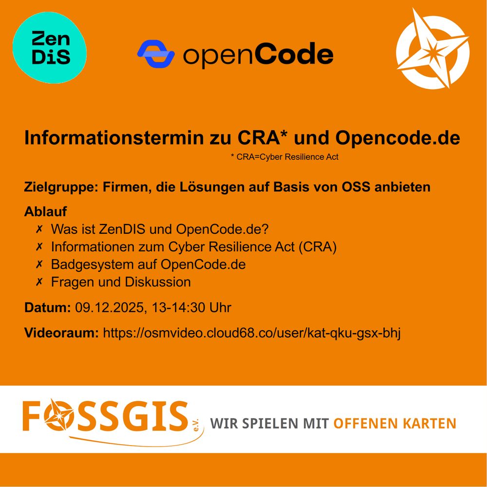
Am 09.12.2025 bietet der @FOSSGISeV von 13 – 14:30 Uhr einen Online-Informationstermin zum Cyper Resilence Act (CRA) und technische Lösungen mit OpenCode.de an.
Raum und weitere Informationen siehe Wikiseite […]
[Original post on mastodon.online]
Raum und weitere Informationen siehe Wikiseite […]
[Original post on mastodon.online]
November 25, 2025 at 8:46 AM
Am 09.12.2025 bietet der @FOSSGISeV von 13 – 14:30 Uhr einen Online-Informationstermin zum Cyper Resilence Act (CRA) und technische Lösungen mit OpenCode.de an.
Raum und weitere Informationen siehe Wikiseite […]
[Original post on mastodon.online]
Raum und weitere Informationen siehe Wikiseite […]
[Original post on mastodon.online]
Reposted by Pirmin Kalberer

In case you missed it, as it was posted on a Friday afternoon: I've written some notes on how to map & survey using @CoMaps & @everydoor when one is trekking without any internet & electricity for a few days!
https://tzovar.as/offline-mapping/
#openstreetmap
https://tzovar.as/offline-mapping/
#openstreetmap

Mapping offline with CoMaps and Every Door
For the first half of November, I’ve been in Peru to do some hikes close to Cusco with friends: First, we did a 5 day trek to the Inca site of Choquequirao and back. After a day and a half of rest back in Cusco, we then did the 4-day Inca trail to Machu Picchu as well. Of course, I wanted to use those opportunities to do some surveying and mapping for _OpenStreetMap_ (OSM) along the way as well. But there are (at least) two potential issues when doing so during multi-day hikes into at least somewhat remote areas: Having internet connectivity & managing phone battery levels.
To give some context about the locations in question: Similar to Machu Picchu, Choquequirao is tucked away on the side of a mountain, surrounded by forests. But unlike its sister site, there is no way to reach that doesn’t involve hiking 25 km as first descending and then climbing 1,600 meters (That is one way, you then do the same in reverse to get back). Given this geography, there’s very little to no internet connectivity along the way, which makes live-mapping very hard. And while the Inca trail is more touristy, even along it there’s ~2 days where there’s no connectivity. Furthermore, most of the campgrounds one encounters have limited if any electricity to recharge batteries as well.
To nevertheless be able to survey and contribute, I used a mix of strategies: Firstly, as I was recording the actual hiking paths with my Garmin _Fenix_ watch, I got GPX tracks of our routes somewhat as a side effect. On a full charge, and with a bit of integrated solar charging, it can record GPS tracks for ~24 hours. And similarly, by just taking holiday snapshots (as well as some more mindful surveying pictures) along the route using my phone, I created some geolocated reference images too. That left the question of how to more directly contribute to OSM, for which I settled for a combination of _CoMaps_ and _Every Door_.
_CoMaps_ 1 is mainly a map & navigation app that is based on OSM and is available for iOS & Android. It works with maps that are fully offline after the initial download. This in itself was already super useful: While we had guides for our treks, it was super useful to be able to quickly pull out a map to check what a given mountain peak we were seeing was - and even read the associated offline Wikipedia article. Or being able to check the current or remaining elevation.
Beyond looking at OSM data, _CoMaps_ also has a (simple) OSM editor, that allows adding & editing points of interest (POI), as well as leaving notes on OSM. And as _CoMaps_ is an _offline-first_ app, it works well offline too: It will queue your edits & notes and keep them safe until you’re back online, at which point the data is sent over to OSM.
While this approach works well for many common POI, _CoMaps_ is by design limited to more common objects, to keep things simple. To be a bit more flexible, I also wanted to use _Every Door_ , which is a more powerful OSM editor designed specifically for surveying. Until recently, it didn’t work super well for pure offline-use, as the background map/satellite layers would not easily cache predictably. Luckily, _Every Door 7.x_ was released in September and has changed this2!
This version has two changes that make fully working offline very easily possible: Firstly, one can now optionally work with vector tiles instead of just the previous raster tiles, thanks to the new plugin architecture. The vector tiles are significantly smaller, so it’s more feasible to have them available offline on a phone for larger regions – which comes at the cost of slower map-rendering speeds. Secondly, the 7.x version of _Every Door_ also allows managing its offline-available data. One can now select areas for which both the OSM data itself and the raster/vector tiles (or even satellite images) should be stored offline.
Once downloaded, the background layer and OSM data are persistently stored, allowing browsing the corresponding regions in _Every Door_ without any connectivity. Unlike _CoMaps_ , _Every Door_ does not automatically push changes back to OSM, instead it requires actively pressing the _Upload_ -button. This is nice for prolonged offline-use, as one can then submit one larger changeset, which one can even annotate with hashtags.
Now that we have ways to collect and edit data offline on the trail, **what about battery life** : Given the assumption that there’s no connectivity during the trek, the biggest battery saving comes from enabling airplane mode to disable the mobile radios. Otherwise the radios would continuously try to find and connect to cell towers, sucking up the battery. Using the phone otherwise for taking pictures and mapping with _CoMaps_ & _Every Door_ , that alone helped bring down the battery use to around ~30-35% of battery capacity in a hiking day.
To further minimize battery use, I just switched off my phone in the evening, only turning it back on the next morning. Both _CoMaps_ and _Every Door_ handle a cold restart perfectly fine without losing the already downloaded/queued data. With that, my phone could easily last 2 days, maybe even a bit more. I carried a power bank to top up my phone every two days, as well as recharging my _Garmin_ watch to continue my GPS recordings too. I didn’t have any _battery anxiety_ with this approach, leaving my (20,000 mAh) power bank more than half-full after the 5 days of hiking.
Overall, this was my first time trying to do some surveying while hiking in (somewhat) off-the-grid locations that are mostly without internet connectivity and electricity. And I wasn’t sure how well it would work, but it turns out **_CoMaps_ and _Every Door_ handled contributing in that way really well**: Once we came back to a place with stable WiFi, I uploaded all edits via both apps without any issues. And when I arrived back home, I used the GPS Tracks to adjust some paths that I had noticed as being slightly wrong along the way and uploaded some images to Panoramax and Wikimedia Commons.
I will definitely continue using this approach for contributing to OSM on my next hikes, and if you plan to go out into nature you can give it a try too, just download the relevant map regions in advance and you’re good to go. Happy hiking!
## References
1. Greshake Tzovaras, B. (2025, May 9). Updates to the ‘Personal API’. Bastian Greshake Tzovaras. https://doi.org/10.59350/8fxh9-3vd91
2. Greshake Tzovaras, B. (2024, August 23). Openly licensed streetview with Panoramax. Bastian Greshake Tzovaras. https://doi.org/10.59350/cjnzq-6cs79
## Footnotes
1. Since _CoMaps_ has forked from _Organic Maps_ , I’ve been trying to contribute and help out a bit where I can, as it’s one of my favorite OSM-based map tools. ↩
2. _Every Door_ is generally one of my favorite surveying tools for OSM, I recently was involved in making a small _getting started_ -guide in Spanish for it. ↩
tzovar.as
November 24, 2025 at 3:15 PM
In case you missed it, as it was posted on a Friday afternoon: I've written some notes on how to map & survey using @CoMaps & @everydoor when one is trekking without any internet & electricity for a few days!
https://tzovar.as/offline-mapping/
#openstreetmap
https://tzovar.as/offline-mapping/
#openstreetmap
Reposted by Pirmin Kalberer
Danke an das Programmkomitee der #fossgis2026 für den Kraftakt und die Meisterleistung am Wochenende das Konferenzprogramm zusammenzustellen.
Die Mails werden die Tage verschickt, das Programm wird noch vor Weihnachten veröffentlicht […]
[Original post on mastodon.online]
Die Mails werden die Tage verschickt, das Programm wird noch vor Weihnachten veröffentlicht […]
[Original post on mastodon.online]

November 23, 2025 at 2:51 PM
Danke an das Programmkomitee der #fossgis2026 für den Kraftakt und die Meisterleistung am Wochenende das Konferenzprogramm zusammenzustellen.
Die Mails werden die Tage verschickt, das Programm wird noch vor Weihnachten veröffentlicht […]
[Original post on mastodon.online]
Die Mails werden die Tage verschickt, das Programm wird noch vor Weihnachten veröffentlicht […]
[Original post on mastodon.online]
Reposted by Pirmin Kalberer
Grüße aus dem @FOSSGISeV Maschinenraum.
Heute trifft sich das Programmkomitee der #fossgis2026 zur Programmgestaltung in einem hybriden Treffen.
Wir freuen uns auf ein interessantes Konferenzprogramm, welches im Laufe des Dezembers veröffentlicht wird.
#fossgis #openstreetmap #osgeo #opendata
Heute trifft sich das Programmkomitee der #fossgis2026 zur Programmgestaltung in einem hybriden Treffen.
Wir freuen uns auf ein interessantes Konferenzprogramm, welches im Laufe des Dezembers veröffentlicht wird.
#fossgis #openstreetmap #osgeo #opendata

November 22, 2025 at 1:18 PM
Grüße aus dem @FOSSGISeV Maschinenraum.
Heute trifft sich das Programmkomitee der #fossgis2026 zur Programmgestaltung in einem hybriden Treffen.
Wir freuen uns auf ein interessantes Konferenzprogramm, welches im Laufe des Dezembers veröffentlicht wird.
#fossgis #openstreetmap #osgeo #opendata
Heute trifft sich das Programmkomitee der #fossgis2026 zur Programmgestaltung in einem hybriden Treffen.
Wir freuen uns auf ein interessantes Konferenzprogramm, welches im Laufe des Dezembers veröffentlicht wird.
#fossgis #openstreetmap #osgeo #opendata
Reposted by Pirmin Kalberer
Das Community-Voting für die #fossgis2026 ist bis zum 17.11.2025 möglich.
Das Ergebnis dient dem Programm-Komitee als Meinungsbild aus der Community & wird in die Bewertung einbezogen.
Vorgehen:
1. Link zur Abstimmung klicken, um sich anzumelden […]
[Original post on mastodon.online]
Das Ergebnis dient dem Programm-Komitee als Meinungsbild aus der Community & wird in die Bewertung einbezogen.
Vorgehen:
1. Link zur Abstimmung klicken, um sich anzumelden […]
[Original post on mastodon.online]

November 7, 2025 at 8:33 AM
Das Community-Voting für die #fossgis2026 ist bis zum 17.11.2025 möglich.
Das Ergebnis dient dem Programm-Komitee als Meinungsbild aus der Community & wird in die Bewertung einbezogen.
Vorgehen:
1. Link zur Abstimmung klicken, um sich anzumelden […]
[Original post on mastodon.online]
Das Ergebnis dient dem Programm-Komitee als Meinungsbild aus der Community & wird in die Bewertung einbezogen.
Vorgehen:
1. Link zur Abstimmung klicken, um sich anzumelden […]
[Original post on mastodon.online]
Reporting back from the Equal Earth code sprint in Graz:
https://kalberer.org/pirmin/blog/equal-earth-ol-sprint/
#Openlayers #equalearth
https://kalberer.org/pirmin/blog/equal-earth-ol-sprint/
#Openlayers #equalearth
Pirmin's Blog - Equal Earth OpenLayers sprint in Graz
kalberer.org
October 22, 2025 at 10:21 PM
Reporting back from the Equal Earth code sprint in Graz:
https://kalberer.org/pirmin/blog/equal-earth-ol-sprint/
#Openlayers #equalearth
https://kalberer.org/pirmin/blog/equal-earth-ol-sprint/
#Openlayers #equalearth
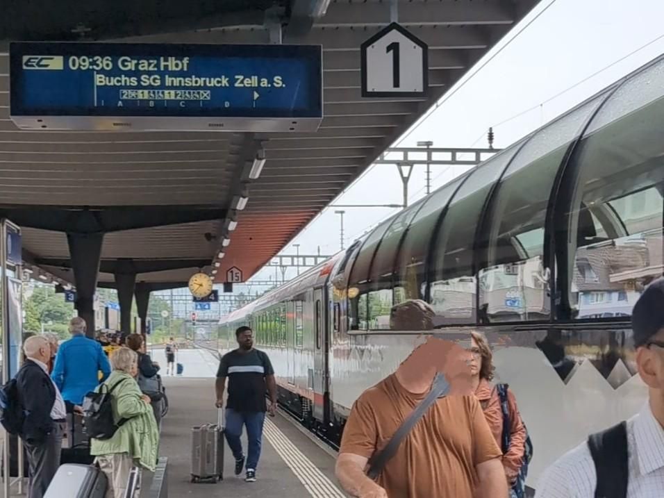
On the way to one of the capital cities of #Openlayers development :mapstodon: 🇦🇹 #equalearth

October 14, 2025 at 6:05 PM
On the way to one of the capital cities of #Openlayers development :mapstodon: 🇦🇹 #equalearth
Reposted by Pirmin Kalberer

I also really love this article "Why I Hate Advocacy" from @mjd https://www.perl.com/pub/2000/12/advocacy.html/ about how tribalism in programming makes it harder to communicate about our tools
(4/?)
(4/?)

Why I Hate Advocacy
Since 1997 Perl.com has published articles about the Perl programming language, its culture and community.
www.perl.com
October 11, 2025 at 12:47 PM
I also really love this article "Why I Hate Advocacy" from @mjd https://www.perl.com/pub/2000/12/advocacy.html/ about how tribalism in programming makes it harder to communicate about our tools
(4/?)
(4/?)
Reposted by Pirmin Kalberer

‘Blueskyism’, Political Violence, and Open Social Networks Under Authoritarianism
on how the last weeks have shifted the threat model for open social networks: from fighting platform decay to the threat of authoritarianism
connectedplaces.online/blueskyism-p...
on how the last weeks have shifted the threat model for open social networks: from fighting platform decay to the threat of authoritarianism
connectedplaces.online/blueskyism-p...

‘Blueskyism’, Political Violence, and Open Social Networks Under Authoritarianism
After Kirk's murder, calls for censorship and the crackdown on political places started to include Bluesky. Open social networks must now fight political suppression as well as platform monopolies.
connectedplaces.online
September 19, 2025 at 3:36 PM
‘Blueskyism’, Political Violence, and Open Social Networks Under Authoritarianism
on how the last weeks have shifted the threat model for open social networks: from fighting platform decay to the threat of authoritarianism
connectedplaces.online/blueskyism-p...
on how the last weeks have shifted the threat model for open social networks: from fighting platform decay to the threat of authoritarianism
connectedplaces.online/blueskyism-p...
Reposted by Pirmin Kalberer
Ankündigung FOSSGIS-Konferenz in 25. - 28. März 2026 in Göttingen.
Freut Euch schon jetzt auf spannende Vorträge, einen lebhaften Austausch mit vielen bekannten (und neuen) Gesichtern!
2026 wird die Konferenz vom @FOSSGISeV sowie der
#OpenStreetMap-Community […]
[Original post on mastodon.online]
Freut Euch schon jetzt auf spannende Vorträge, einen lebhaften Austausch mit vielen bekannten (und neuen) Gesichtern!
2026 wird die Konferenz vom @FOSSGISeV sowie der
#OpenStreetMap-Community […]
[Original post on mastodon.online]

September 15, 2025 at 10:57 AM
Ankündigung FOSSGIS-Konferenz in 25. - 28. März 2026 in Göttingen.
Freut Euch schon jetzt auf spannende Vorträge, einen lebhaften Austausch mit vielen bekannten (und neuen) Gesichtern!
2026 wird die Konferenz vom @FOSSGISeV sowie der
#OpenStreetMap-Community […]
[Original post on mastodon.online]
Freut Euch schon jetzt auf spannende Vorträge, einen lebhaften Austausch mit vielen bekannten (und neuen) Gesichtern!
2026 wird die Konferenz vom @FOSSGISeV sowie der
#OpenStreetMap-Community […]
[Original post on mastodon.online]
Reposted by Pirmin Kalberer

3D Gaussian Splats leading organizations across the geospatial, graphics, and standards domains — including Khronos Group, Open Geospatial Consortium (OGC), Niantic Spatial, Cesium, and Esri have come together to integrate 3D Geospatial Gaussian Splats into […]
[Original post on fosstodon.org]
[Original post on fosstodon.org]

August 7, 2025 at 8:36 PM
3D Gaussian Splats leading organizations across the geospatial, graphics, and standards domains — including Khronos Group, Open Geospatial Consortium (OGC), Niantic Spatial, Cesium, and Esri have come together to integrate 3D Geospatial Gaussian Splats into […]
[Original post on fosstodon.org]
[Original post on fosstodon.org]
Reposted by Pirmin Kalberer
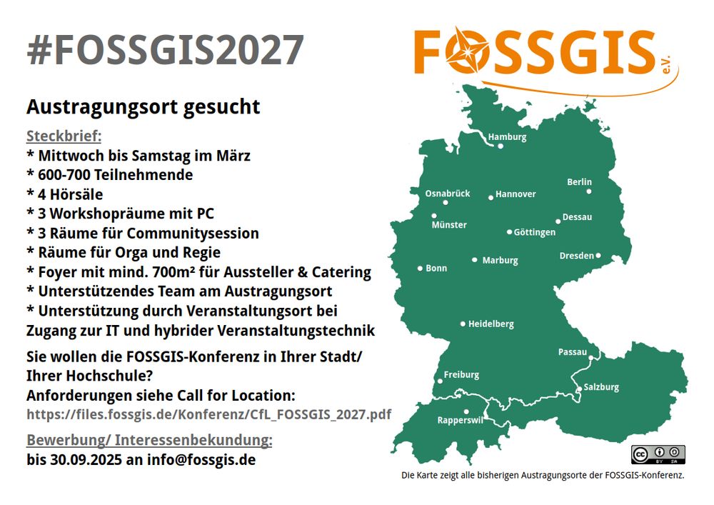
#fossgiskonferenz sucht Austragungsort - Call for Location: https://files.fossgis.de/Konferenz/CfL_FOSSGIS_2027.pdf
Bewerbungen für die #fossgis2027 bis zum 30.09.2025 per Email an [email protected].
Selbstverständlich nehmen wir auch Interessenbekundungen […]
[Original post on mastodon.online]
Bewerbungen für die #fossgis2027 bis zum 30.09.2025 per Email an [email protected].
Selbstverständlich nehmen wir auch Interessenbekundungen […]
[Original post on mastodon.online]
August 7, 2025 at 7:20 AM
#fossgiskonferenz sucht Austragungsort - Call for Location: https://files.fossgis.de/Konferenz/CfL_FOSSGIS_2027.pdf
Bewerbungen für die #fossgis2027 bis zum 30.09.2025 per Email an [email protected].
Selbstverständlich nehmen wir auch Interessenbekundungen […]
[Original post on mastodon.online]
Bewerbungen für die #fossgis2027 bis zum 30.09.2025 per Email an [email protected].
Selbstverständlich nehmen wir auch Interessenbekundungen […]
[Original post on mastodon.online]
July 14, 2025 at 6:49 PM
July 14, 2025 at 8:06 AM
Implementing App notifications: The FOSS way - DEV Community
https://dev.to/dilutewater/implementing-app-notifications-the-foss-way-lc2
https://dev.to/dilutewater/implementing-app-notifications-the-foss-way-lc2
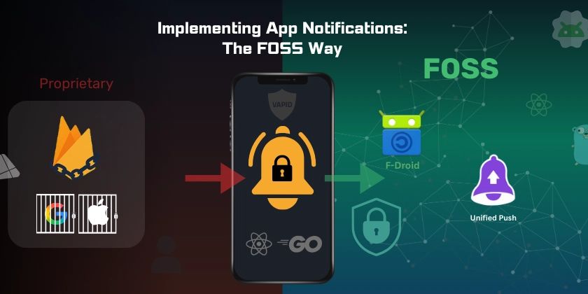
Implementing App notifications: The FOSS way
The Beginning: Building My First "Real" App Recently, I embarked on building a...
dev.to
July 12, 2025 at 2:30 PM
Implementing App notifications: The FOSS way - DEV Community
https://dev.to/dilutewater/implementing-app-notifications-the-foss-way-lc2
https://dev.to/dilutewater/implementing-app-notifications-the-foss-way-lc2
Real-world maps are helping developers make games about trains and farms #OpenStreetMap #osm
https://www.theverge.com/games/672035/openstreetmap-data-games
https://www.theverge.com/games/672035/openstreetmap-data-games
Real-world map data is helping make better games about farms and transportation
Titles like City Bus Manager and Global Farmer are benefiting from OpenStreetMap.
www.theverge.com
May 28, 2025 at 5:37 PM
Real-world maps are helping developers make games about trains and farms #OpenStreetMap #osm
https://www.theverge.com/games/672035/openstreetmap-data-games
https://www.theverge.com/games/672035/openstreetmap-data-games
Reposted by Pirmin Kalberer

Reposted by Pirmin Kalberer
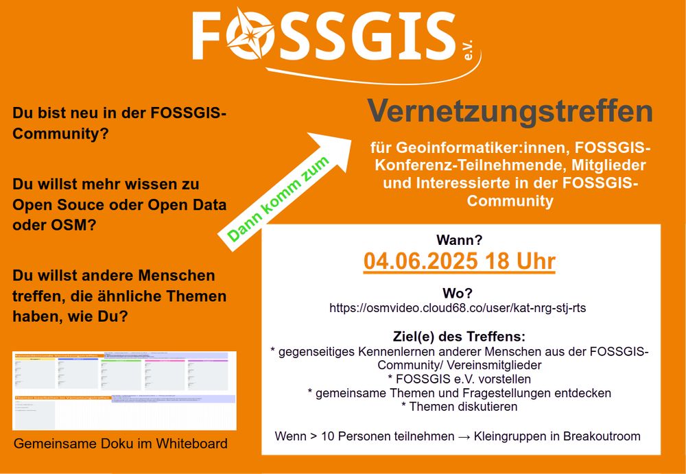
Du bist neu in der #fossgis #community? Du willst andere Menschen treffen, die ähnliche Themen haben, wie Du?
Dann komm zum Vernetzungstreffen @FOSSGISeV am 04.06.2025, 18 Uhr. Dieses findet Online statt und hat das gegenseitige Kennenlernen und gemeinsame […]
[Original post on mastodon.online]
Dann komm zum Vernetzungstreffen @FOSSGISeV am 04.06.2025, 18 Uhr. Dieses findet Online statt und hat das gegenseitige Kennenlernen und gemeinsame […]
[Original post on mastodon.online]
May 23, 2025 at 7:10 AM
Du bist neu in der #fossgis #community? Du willst andere Menschen treffen, die ähnliche Themen haben, wie Du?
Dann komm zum Vernetzungstreffen @FOSSGISeV am 04.06.2025, 18 Uhr. Dieses findet Online statt und hat das gegenseitige Kennenlernen und gemeinsame […]
[Original post on mastodon.online]
Dann komm zum Vernetzungstreffen @FOSSGISeV am 04.06.2025, 18 Uhr. Dieses findet Online statt und hat das gegenseitige Kennenlernen und gemeinsame […]
[Original post on mastodon.online]
Reposted by Pirmin Kalberer

Wie lassen sich offene Geodaten für Umwelt- und Stadtplanung nutzen? Wir zeigen, wie Einzelbäume flächendeckend erfasst werden können – mit Open Source Ansatz und einer Live-Demo.
#opensource #opendata
https://www.mundialis.de/webinar-aufzeichnung-einzelbaumerkennung/
#opensource #opendata
https://www.mundialis.de/webinar-aufzeichnung-einzelbaumerkennung/
May 16, 2025 at 7:30 AM
Wie lassen sich offene Geodaten für Umwelt- und Stadtplanung nutzen? Wir zeigen, wie Einzelbäume flächendeckend erfasst werden können – mit Open Source Ansatz und einer Live-Demo.
#opensource #opendata
https://www.mundialis.de/webinar-aufzeichnung-einzelbaumerkennung/
#opensource #opendata
https://www.mundialis.de/webinar-aufzeichnung-einzelbaumerkennung/