


Qiusheng Wu
@giswqs.bsky.social
Associate Professor @UTKnoxville | Amazon Scholar | Creator of #geemap & #leafmap | Talk about #Geospatial #GeoPython #DataViz #GIS #FOSS #EarthEngine
Pinned
Qiusheng Wu
@giswqs.bsky.social
· Jun 28
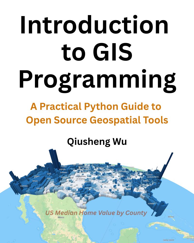
📣 Exciting News! The full-color print edition of my book “Introduction to GIS Programming: A Practical Python Guide to Open Source Geospatial Tools” is now available on Amazon!
📘 Grab your copy: amazon.com/dp/B0FFW34LL3
Prefer digital? The PDF version is available on Leanpub: leanpub.com/gispro
📘 Grab your copy: amazon.com/dp/B0FFW34LL3
Prefer digital? The PDF version is available on Leanpub: leanpub.com/gispro
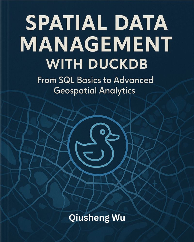
I’m thrilled to share that my new book (Spatial Data Management with DuckDB) is now published! 🎉
At 430 pages, this book provides a practical, hands-on guide to scalable geospatial analytics and visualization using DuckDB. All code examples are open-source and freely available on GitHub.
At 430 pages, this book provides a practical, hands-on guide to scalable geospatial analytics and visualization using DuckDB. All code examples are open-source and freely available on GitHub.

November 15, 2025 at 6:44 PM
I’m thrilled to share that my new book (Spatial Data Management with DuckDB) is now published! 🎉
At 430 pages, this book provides a practical, hands-on guide to scalable geospatial analytics and visualization using DuckDB. All code examples are open-source and freely available on GitHub.
At 430 pages, this book provides a practical, hands-on guide to scalable geospatial analytics and visualization using DuckDB. All code examples are open-source and freely available on GitHub.
I’ve been working on a new chapter for my upcoming DuckDB book (duckdb.gishub.org), focusing on large-scale geospatial analytics. As part of the chapter, I generated an H3 heatmap of 2.5 billion global building footprints from Overture Maps.
Stay tuned for the book release!
#geospatial #duckdb
Stay tuned for the book release!
#geospatial #duckdb
November 14, 2025 at 2:04 PM
I’ve been working on a new chapter for my upcoming DuckDB book (duckdb.gishub.org), focusing on large-scale geospatial analytics. As part of the chapter, I generated an H3 heatmap of 2.5 billion global building footprints from Overture Maps.
Stay tuned for the book release!
#geospatial #duckdb
Stay tuned for the book release!
#geospatial #duckdb
🚁✨ Workshop Recordings Now Live from CANVAS 2025!
Yesterday at the CANVAS 2025 Conference in Salt Lake City, Dr. Jinha Jung and I had the pleasure of leading a 4-hour hands-on workshop on managing and analyzing drone imagery using open-source tools.
👉 Sign up for a FREE D2S account: ps2.d2s.org
Yesterday at the CANVAS 2025 Conference in Salt Lake City, Dr. Jinha Jung and I had the pleasure of leading a 4-hour hands-on workshop on managing and analyzing drone imagery using open-source tools.
👉 Sign up for a FREE D2S account: ps2.d2s.org

November 11, 2025 at 9:50 PM
🚁✨ Workshop Recordings Now Live from CANVAS 2025!
Yesterday at the CANVAS 2025 Conference in Salt Lake City, Dr. Jinha Jung and I had the pleasure of leading a 4-hour hands-on workshop on managing and analyzing drone imagery using open-source tools.
👉 Sign up for a FREE D2S account: ps2.d2s.org
Yesterday at the CANVAS 2025 Conference in Salt Lake City, Dr. Jinha Jung and I had the pleasure of leading a 4-hour hands-on workshop on managing and analyzing drone imagery using open-source tools.
👉 Sign up for a FREE D2S account: ps2.d2s.org
Learn how to visualize Cloud Optimized GeoTIFFs (COGs) right in your browser – no tile server is needed!
👉 Notebook example: leafmap.org/notebooks/10...
📺 Full video tutorial on YouTube: www.youtube.com/@giswqs/videos
#geospatial #opensource #leafmap #python
👉 Notebook example: leafmap.org/notebooks/10...
📺 Full video tutorial on YouTube: www.youtube.com/@giswqs/videos
#geospatial #opensource #leafmap #python
November 6, 2025 at 3:23 PM
Learn how to visualize Cloud Optimized GeoTIFFs (COGs) right in your browser – no tile server is needed!
👉 Notebook example: leafmap.org/notebooks/10...
📺 Full video tutorial on YouTube: www.youtube.com/@giswqs/videos
#geospatial #opensource #leafmap #python
👉 Notebook example: leafmap.org/notebooks/10...
📺 Full video tutorial on YouTube: www.youtube.com/@giswqs/videos
#geospatial #opensource #leafmap #python
📯 I’m excited to share the news about my upcoming book:
📘 Spatial Data Management with DuckDB: From SQL Basics to Advanced Geospatial Analytics
🔗 GitHub Repository: github.com/giswqs/duckd...
🌐 Book Website: duckdb.gishub.org
The book will be released later this month. Stay tuned for updates!
📘 Spatial Data Management with DuckDB: From SQL Basics to Advanced Geospatial Analytics
🔗 GitHub Repository: github.com/giswqs/duckd...
🌐 Book Website: duckdb.gishub.org
The book will be released later this month. Stay tuned for updates!
November 3, 2025 at 1:04 PM
📯 I’m excited to share the news about my upcoming book:
📘 Spatial Data Management with DuckDB: From SQL Basics to Advanced Geospatial Analytics
🔗 GitHub Repository: github.com/giswqs/duckd...
🌐 Book Website: duckdb.gishub.org
The book will be released later this month. Stay tuned for updates!
📘 Spatial Data Management with DuckDB: From SQL Basics to Advanced Geospatial Analytics
🔗 GitHub Repository: github.com/giswqs/duckd...
🌐 Book Website: duckdb.gishub.org
The book will be released later this month. Stay tuned for updates!
Wyvern Hyperspectral Data Visualization Made Easy
Learn how to easily visualize high-resolution hyperspectral imagery from Wyvern using the HyperCoast Python package.
Notebook example: hypercoast.org/examples/wyv...
Wyvern Open Data: wyvern.space/open-data
#Wyvern #Hyperspectral
Learn how to easily visualize high-resolution hyperspectral imagery from Wyvern using the HyperCoast Python package.
Notebook example: hypercoast.org/examples/wyv...
Wyvern Open Data: wyvern.space/open-data
#Wyvern #Hyperspectral

October 27, 2025 at 1:19 PM
Wyvern Hyperspectral Data Visualization Made Easy
Learn how to easily visualize high-resolution hyperspectral imagery from Wyvern using the HyperCoast Python package.
Notebook example: hypercoast.org/examples/wyv...
Wyvern Open Data: wyvern.space/open-data
#Wyvern #Hyperspectral
Learn how to easily visualize high-resolution hyperspectral imagery from Wyvern using the HyperCoast Python package.
Notebook example: hypercoast.org/examples/wyv...
Wyvern Open Data: wyvern.space/open-data
#Wyvern #Hyperspectral
A sneak peek at the new layer and legend controls in the AnyMap package, making it easier than ever to style your map layers interactively with just a few clicks.
GitHub: github.com/opengeos/any...
#geospatial #python #opensource
GitHub: github.com/opengeos/any...
#geospatial #python #opensource
October 26, 2025 at 2:51 PM
A sneak peek at the new layer and legend controls in the AnyMap package, making it easier than ever to style your map layers interactively with just a few clicks.
GitHub: github.com/opengeos/any...
#geospatial #python #opensource
GitHub: github.com/opengeos/any...
#geospatial #python #opensource
Reposted by Qiusheng Wu

The 1.4 release of @duckdb.org supports using a DuckDB database to serve vector tiles!
Of course, I had to try this out in R.
Check it out: all 242,000 US Census block groups dynamically served as vector tiles from a DuckDB database, displayed on a MapLibre map from R in Positron.
Of course, I had to try this out in R.
Check it out: all 242,000 US Census block groups dynamically served as vector tiles from a DuckDB database, displayed on a MapLibre map from R in Positron.
October 24, 2025 at 6:19 PM
The 1.4 release of @duckdb.org supports using a DuckDB database to serve vector tiles!
Of course, I had to try this out in R.
Check it out: all 242,000 US Census block groups dynamically served as vector tiles from a DuckDB database, displayed on a MapLibre map from R in Positron.
Of course, I had to try this out in R.
Check it out: all 242,000 US Census block groups dynamically served as vector tiles from a DuckDB database, displayed on a MapLibre map from R in Positron.
🚀 anymap v0.6 is here!
This release comes packed with major new features.
These updates make interactive geospatial analysis in Python smoother and more powerful than ever.
🔗 GitHub: github.com/opengeos/any...
📘 Docs: anymap.dev
#python #geospatial #jupyter #dataviz
This release comes packed with major new features.
These updates make interactive geospatial analysis in Python smoother and more powerful than ever.
🔗 GitHub: github.com/opengeos/any...
📘 Docs: anymap.dev
#python #geospatial #jupyter #dataviz
October 24, 2025 at 5:28 PM
🚀 anymap v0.6 is here!
This release comes packed with major new features.
These updates make interactive geospatial analysis in Python smoother and more powerful than ever.
🔗 GitHub: github.com/opengeos/any...
📘 Docs: anymap.dev
#python #geospatial #jupyter #dataviz
This release comes packed with major new features.
These updates make interactive geospatial analysis in Python smoother and more powerful than ever.
🔗 GitHub: github.com/opengeos/any...
📘 Docs: anymap.dev
#python #geospatial #jupyter #dataviz
The recording of my presentation at the UTK Open Access Week is available on YouTube now: youtu.be/nBFAvvHiBmc
Title: Open Publishing in Action: Creating Interactive Books with Jupyter Book and MyST Markdown
GitHub Repo: lnkd.in/eR3NEYrx
#openaccess #jupyter #opensource
Title: Open Publishing in Action: Creating Interactive Books with Jupyter Book and MyST Markdown
GitHub Repo: lnkd.in/eR3NEYrx
#openaccess #jupyter #opensource

October 23, 2025 at 1:55 PM
The recording of my presentation at the UTK Open Access Week is available on YouTube now: youtu.be/nBFAvvHiBmc
Title: Open Publishing in Action: Creating Interactive Books with Jupyter Book and MyST Markdown
GitHub Repo: lnkd.in/eR3NEYrx
#openaccess #jupyter #opensource
Title: Open Publishing in Action: Creating Interactive Books with Jupyter Book and MyST Markdown
GitHub Repo: lnkd.in/eR3NEYrx
#openaccess #jupyter #opensource
🚀 Visualize Big Vector Data in Python—FAST!
Discover this one-line Python trick using Leafmap + DuckDB to instantly render huge vector datasets—even gigabytes in size—right in your Jupyter notebook.
📌 Watch the full video tutorial on YouTube: www.youtube.com/@giswqs/videos
Discover this one-line Python trick using Leafmap + DuckDB to instantly render huge vector datasets—even gigabytes in size—right in your Jupyter notebook.
📌 Watch the full video tutorial on YouTube: www.youtube.com/@giswqs/videos
October 22, 2025 at 1:18 PM
🚀 Visualize Big Vector Data in Python—FAST!
Discover this one-line Python trick using Leafmap + DuckDB to instantly render huge vector datasets—even gigabytes in size—right in your Jupyter notebook.
📌 Watch the full video tutorial on YouTube: www.youtube.com/@giswqs/videos
Discover this one-line Python trick using Leafmap + DuckDB to instantly render huge vector datasets—even gigabytes in size—right in your Jupyter notebook.
📌 Watch the full video tutorial on YouTube: www.youtube.com/@giswqs/videos
🎯 AI Agents for Microsoft Planetary Computer: Explore Satellite Data with Zero Code
Full video tutorial available on YouTube: www.youtube.com/@giswqs/videos
#geospatial #GeoAI #opensource #PlanetaryComputer
Full video tutorial available on YouTube: www.youtube.com/@giswqs/videos
#geospatial #GeoAI #opensource #PlanetaryComputer
October 20, 2025 at 12:54 PM
🎯 AI Agents for Microsoft Planetary Computer: Explore Satellite Data with Zero Code
Full video tutorial available on YouTube: www.youtube.com/@giswqs/videos
#geospatial #GeoAI #opensource #PlanetaryComputer
Full video tutorial available on YouTube: www.youtube.com/@giswqs/videos
#geospatial #GeoAI #opensource #PlanetaryComputer
📯 The University of Tennessee Open Access Week is taking place this week. I’ll be presenting a session during the event
Webinar: Open Publishing in Action: Creating Interactive Books with Jupyter Book and MyST Markdown
Time: October 21st, 2:00 - 3:00pm
Zoom link: calendar.utk.edu/event/open-p...
Webinar: Open Publishing in Action: Creating Interactive Books with Jupyter Book and MyST Markdown
Time: October 21st, 2:00 - 3:00pm
Zoom link: calendar.utk.edu/event/open-p...

October 20, 2025 at 12:11 PM
📯 The University of Tennessee Open Access Week is taking place this week. I’ll be presenting a session during the event
Webinar: Open Publishing in Action: Creating Interactive Books with Jupyter Book and MyST Markdown
Time: October 21st, 2:00 - 3:00pm
Zoom link: calendar.utk.edu/event/open-p...
Webinar: Open Publishing in Action: Creating Interactive Books with Jupyter Book and MyST Markdown
Time: October 21st, 2:00 - 3:00pm
Zoom link: calendar.utk.edu/event/open-p...
🚀 GeoAI v0.16.0 is here!
Train image segmentation models and instantly visualize performance metrics with a single line of Python code. 💡
📦 GitHub: github.com/opengeos/geoai
📓 Example notebook: opengeoai.org/examples/tra...
#GeoAI #DeepLearning #GeospatialAI #Python #OpenSource #RemoteSensing
Train image segmentation models and instantly visualize performance metrics with a single line of Python code. 💡
📦 GitHub: github.com/opengeos/geoai
📓 Example notebook: opengeoai.org/examples/tra...
#GeoAI #DeepLearning #GeospatialAI #Python #OpenSource #RemoteSensing

October 16, 2025 at 10:06 PM
🚀 GeoAI v0.16.0 is here!
Train image segmentation models and instantly visualize performance metrics with a single line of Python code. 💡
📦 GitHub: github.com/opengeos/geoai
📓 Example notebook: opengeoai.org/examples/tra...
#GeoAI #DeepLearning #GeospatialAI #Python #OpenSource #RemoteSensing
Train image segmentation models and instantly visualize performance metrics with a single line of Python code. 💡
📦 GitHub: github.com/opengeos/geoai
📓 Example notebook: opengeoai.org/examples/tra...
#GeoAI #DeepLearning #GeospatialAI #Python #OpenSource #RemoteSensing
Boost Your Workflow in Leafmap with the New Floating Sidebar 🚀
Full video tutorial available on YouTube: youtube.com/@giswqs/videos
#Leafmap #PythonMapping #Geospatial #GIS #MapLibre #ipywidgets
Full video tutorial available on YouTube: youtube.com/@giswqs/videos
#Leafmap #PythonMapping #Geospatial #GIS #MapLibre #ipywidgets

October 13, 2025 at 12:51 PM
Boost Your Workflow in Leafmap with the New Floating Sidebar 🚀
Full video tutorial available on YouTube: youtube.com/@giswqs/videos
#Leafmap #PythonMapping #Geospatial #GIS #MapLibre #ipywidgets
Full video tutorial available on YouTube: youtube.com/@giswqs/videos
#Leafmap #PythonMapping #Geospatial #GIS #MapLibre #ipywidgets
🚀 The leafmap Python package just got a major usability boost — introducing the floating sidebar panel! 🎉
This new feature lets you:
✅ Effortlessly control layer visibility and style
✅ Add custom ipywidgets for interactive geospatial apps
👉 Try it out on Colab:
github.com/opengeos/lea...
This new feature lets you:
✅ Effortlessly control layer visibility and style
✅ Add custom ipywidgets for interactive geospatial apps
👉 Try it out on Colab:
github.com/opengeos/lea...
October 8, 2025 at 2:54 PM
🚀 The leafmap Python package just got a major usability boost — introducing the floating sidebar panel! 🎉
This new feature lets you:
✅ Effortlessly control layer visibility and style
✅ Add custom ipywidgets for interactive geospatial apps
👉 Try it out on Colab:
github.com/opengeos/lea...
This new feature lets you:
✅ Effortlessly control layer visibility and style
✅ Add custom ipywidgets for interactive geospatial apps
👉 Try it out on Colab:
github.com/opengeos/lea...
Unlock the power of instance segmentation for buildings using the open-source GeoAI Python package! 🏗️ In this hands-on tutorial, you'll learn how to train, run, and evaluate a deep learning model that can accurately detect and separate individual buildings
www.youtube.com/@giswqs/videos
www.youtube.com/@giswqs/videos

October 8, 2025 at 1:32 PM
Unlock the power of instance segmentation for buildings using the open-source GeoAI Python package! 🏗️ In this hands-on tutorial, you'll learn how to train, run, and evaluate a deep learning model that can accurately detect and separate individual buildings
www.youtube.com/@giswqs/videos
www.youtube.com/@giswqs/videos
Need satellite training data fast? 🛰️ In this step-by-step tutorial, learn how to prepare geospatial training data for deep learning in seconds using the free open-source GeoAI Python package.
Video available on YouTube: www.youtube.com/@giswqs/videos
Video available on YouTube: www.youtube.com/@giswqs/videos

October 6, 2025 at 1:41 PM
Need satellite training data fast? 🛰️ In this step-by-step tutorial, learn how to prepare geospatial training data for deep learning in seconds using the free open-source GeoAI Python package.
Video available on YouTube: www.youtube.com/@giswqs/videos
Video available on YouTube: www.youtube.com/@giswqs/videos
🚀 Here’s a sneak peek at instance segmentation on aerial imagery powered by the GeoAI Python package. 🌍✨
👉 Stay tuned for the full update coming next week!
🔗 GitHub: github.com/opengeos/geoai
👉 Stay tuned for the full update coming next week!
🔗 GitHub: github.com/opengeos/geoai
October 3, 2025 at 8:58 PM
🚀 Here’s a sneak peek at instance segmentation on aerial imagery powered by the GeoAI Python package. 🌍✨
👉 Stay tuned for the full update coming next week!
🔗 GitHub: github.com/opengeos/geoai
👉 Stay tuned for the full update coming next week!
🔗 GitHub: github.com/opengeos/geoai
GeoAI Made Easy: Learn the Python Package Step-by-Step (Beginner Friendly)
🧠 No deep learning background needed — just follow along and you'll be detecting objects in no time!
Video available on YouTube: www.youtube.com/@giswqs/videos
🧠 No deep learning background needed — just follow along and you'll be detecting objects in no time!
Video available on YouTube: www.youtube.com/@giswqs/videos

October 3, 2025 at 12:53 PM
GeoAI Made Easy: Learn the Python Package Step-by-Step (Beginner Friendly)
🧠 No deep learning background needed — just follow along and you'll be detecting objects in no time!
Video available on YouTube: www.youtube.com/@giswqs/videos
🧠 No deep learning background needed — just follow along and you'll be detecting objects in no time!
Video available on YouTube: www.youtube.com/@giswqs/videos
🚀 Exciting news! The GeoAI Python package just got a major upgrade. It now supports interactive geospatial data visualization powered by AI Agents. 🌍✨
GitHub: github.com/opengeos/geoai
Full tutorial: youtube.com/@giswqs
#geospatial #mapping #python #GeoAI #AI
GitHub: github.com/opengeos/geoai
Full tutorial: youtube.com/@giswqs
#geospatial #mapping #python #GeoAI #AI
October 1, 2025 at 1:12 PM
🚀 Exciting news! The GeoAI Python package just got a major upgrade. It now supports interactive geospatial data visualization powered by AI Agents. 🌍✨
GitHub: github.com/opengeos/geoai
Full tutorial: youtube.com/@giswqs
#geospatial #mapping #python #GeoAI #AI
GitHub: github.com/opengeos/geoai
Full tutorial: youtube.com/@giswqs
#geospatial #mapping #python #GeoAI #AI
🚀 The OBS Zoom-to-Mouse Bug on Linux… FINALLY Solved! 🎉
👉 Watch the full breakdown and solution here: youtu.be/relTN31l0Zo
Hopefully this helps fellow OBS users and educators who’ve been struggling with the same problem.
#OBSStudio #Linux #OpenSource
👉 Watch the full breakdown and solution here: youtu.be/relTN31l0Zo
Hopefully this helps fellow OBS users and educators who’ve been struggling with the same problem.
#OBSStudio #Linux #OpenSource

September 29, 2025 at 2:05 PM
🚀 The OBS Zoom-to-Mouse Bug on Linux… FINALLY Solved! 🎉
👉 Watch the full breakdown and solution here: youtu.be/relTN31l0Zo
Hopefully this helps fellow OBS users and educators who’ve been struggling with the same problem.
#OBSStudio #Linux #OpenSource
👉 Watch the full breakdown and solution here: youtu.be/relTN31l0Zo
Hopefully this helps fellow OBS users and educators who’ve been struggling with the same problem.
#OBSStudio #Linux #OpenSource
🚀 Thrilled to share that my Introduction to GIS Programming book is once again the #1 best-seller in the GIS & Remote Sensing category on Amazon! 📚
📖 Amazon: www.amazon.com/Introduction...
🌐 Book website: gispro.gishub.org
#GIS #Geospatial #Python #OpenSource #RemoteSensing
📖 Amazon: www.amazon.com/Introduction...
🌐 Book website: gispro.gishub.org
#GIS #Geospatial #Python #OpenSource #RemoteSensing

September 20, 2025 at 2:47 AM
🚀 Thrilled to share that my Introduction to GIS Programming book is once again the #1 best-seller in the GIS & Remote Sensing category on Amazon! 📚
📖 Amazon: www.amazon.com/Introduction...
🌐 Book website: gispro.gishub.org
#GIS #Geospatial #Python #OpenSource #RemoteSensing
📖 Amazon: www.amazon.com/Introduction...
🌐 Book website: gispro.gishub.org
#GIS #Geospatial #Python #OpenSource #RemoteSensing
🚀 Exciting update! The GeoAI Python package is getting even smarter — soon it will support AI agents.
That means you’ll be able to use natural language to effortlessly download, analyze, and visualize geospatial data 🌍🤖
Stay tuned for the upcoming release!
🔗 GitHub: github.com/opengeos/geoai
That means you’ll be able to use natural language to effortlessly download, analyze, and visualize geospatial data 🌍🤖
Stay tuned for the upcoming release!
🔗 GitHub: github.com/opengeos/geoai
September 14, 2025 at 2:11 PM
🚀 Exciting update! The GeoAI Python package is getting even smarter — soon it will support AI agents.
That means you’ll be able to use natural language to effortlessly download, analyze, and visualize geospatial data 🌍🤖
Stay tuned for the upcoming release!
🔗 GitHub: github.com/opengeos/geoai
That means you’ll be able to use natural language to effortlessly download, analyze, and visualize geospatial data 🌍🤖
Stay tuned for the upcoming release!
🔗 GitHub: github.com/opengeos/geoai
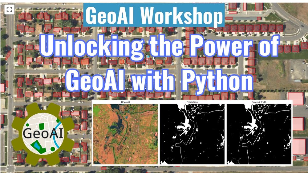
🚀 The recording of the 2-hour GeoAI Workshop is now available! 🎥✨
📺 Video: youtu.be/jdK-cleFUkc
💻 GitHub: github.com/opengeos/geoai
📓 Notebook: opengeoai.org/workshops/TN...
#geospatial #geoai #ai #satellite #python
📺 Video: youtu.be/jdK-cleFUkc
💻 GitHub: github.com/opengeos/geoai
📓 Notebook: opengeoai.org/workshops/TN...
#geospatial #geoai #ai #satellite #python
September 12, 2025 at 5:50 PM
🚀 The recording of the 2-hour GeoAI Workshop is now available! 🎥✨
📺 Video: youtu.be/jdK-cleFUkc
💻 GitHub: github.com/opengeos/geoai
📓 Notebook: opengeoai.org/workshops/TN...
#geospatial #geoai #ai #satellite #python
📺 Video: youtu.be/jdK-cleFUkc
💻 GitHub: github.com/opengeos/geoai
📓 Notebook: opengeoai.org/workshops/TN...
#geospatial #geoai #ai #satellite #python