


Richard Webb
@fasgadh.bsky.social
Knackered ex orienteer and map collector- now on a bike much of the time. Hill bagger.
East Lothian.
Unfortunately due to some authoritarian overreach from our neighbours and overlords and over enthusiastic compliance, I am unable to easily access DMs.
East Lothian.
Unfortunately due to some authoritarian overreach from our neighbours and overlords and over enthusiastic compliance, I am unable to easily access DMs.
Titterstone Clee Hill 1984. 1980s Harlequins maps had a very distinctive look. Fast grassland with mining and quarrying heritage. #Orienteering #OldOrienteeringMaps #Maps #Shropshire #Harlequins

November 30, 2025 at 5:36 PM
Titterstone Clee Hill 1984. 1980s Harlequins maps had a very distinctive look. Fast grassland with mining and quarrying heritage. #Orienteering #OldOrienteeringMaps #Maps #Shropshire #Harlequins
Blea Tarn 1980. Northern Championships. I was lucky enough to run on this map again, many years later. A superb area with runnable grassland and lovely scenery. Finish was in a big garden. #OldOrienteeringMaps #LakeDistrict #Maps #Orienteering #WCOC
www.geograph.org.uk/photo/3618732
www.geograph.org.uk/photo/3618732

November 27, 2025 at 7:52 PM
Blea Tarn 1980. Northern Championships. I was lucky enough to run on this map again, many years later. A superb area with runnable grassland and lovely scenery. Finish was in a big garden. #OldOrienteeringMaps #LakeDistrict #Maps #Orienteering #WCOC
www.geograph.org.uk/photo/3618732
www.geograph.org.uk/photo/3618732
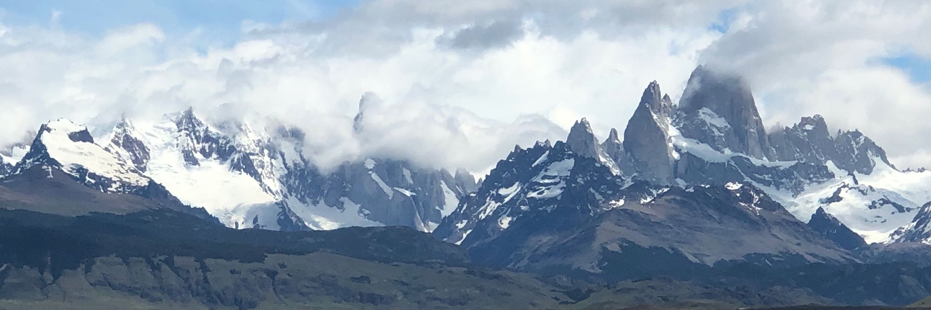
Heading north - Cargo ship in the fjords of Patagonia, a few hours out from Puerto Natales

November 26, 2025 at 5:14 PM
Heading north - Cargo ship in the fjords of Patagonia, a few hours out from Puerto Natales
How many years will Authoritarian Labour demand for this "illegal" demonstration?

November 26, 2025 at 8:58 AM
How many years will Authoritarian Labour demand for this "illegal" demonstration?
East Monaughty 1980. Clearfelling soon took this forest off the fixture list. I would have spent a lot of time on an EUOC bus to get there. Premarked maps were a well loved luxury at this time.
#OldOrienteeringMaps #Maps #Orienteering #Moray #MoravianOrienteers
www.geograph.org.uk/photo/3249538
#OldOrienteeringMaps #Maps #Orienteering #Moray #MoravianOrienteers
www.geograph.org.uk/photo/3249538

November 23, 2025 at 11:17 AM
East Monaughty 1980. Clearfelling soon took this forest off the fixture list. I would have spent a lot of time on an EUOC bus to get there. Premarked maps were a well loved luxury at this time.
#OldOrienteeringMaps #Maps #Orienteering #Moray #MoravianOrienteers
www.geograph.org.uk/photo/3249538
#OldOrienteeringMaps #Maps #Orienteering #Moray #MoravianOrienteers
www.geograph.org.uk/photo/3249538
For the first time for many years I had a go. Getting around the Orange course without mishap.

November 22, 2025 at 3:34 PM
For the first time for many years I had a go. Getting around the Orange course without mishap.
Blackford Hill event today on a 1:5000 map. Nearly 50 years ago the maps had smaller scales - 1:15,000
#OldOrienteeringMaps #Map #ESOC
#OldOrienteeringMaps #Map #ESOC

November 22, 2025 at 10:31 AM
Blackford Hill event today on a 1:5000 map. Nearly 50 years ago the maps had smaller scales - 1:15,000
#OldOrienteeringMaps #Map #ESOC
#OldOrienteeringMaps #Map #ESOC
Moorland near Selkirk. Looking east from the edge of Elibank Forest with self seeded Sitka everywhere. Grazed by sheep and their tracks made walking here unbelievably easy.

November 21, 2025 at 8:44 AM
Moorland near Selkirk. Looking east from the edge of Elibank Forest with self seeded Sitka everywhere. Grazed by sheep and their tracks made walking here unbelievably easy.
Autumn turns to Winter - a handover shot with the last of the colour on the larches vrs the first of the snow. Elibank Forest, Tweeddale today.

November 20, 2025 at 8:15 PM
Autumn turns to Winter - a handover shot with the last of the colour on the larches vrs the first of the snow. Elibank Forest, Tweeddale today.
By the time you get to 20th November, Autumn is long gone. No longer mists and mellow fruitfulness. Farm thing I suppose.
Wonderful weather - I was out in Tweeddale today and really enjoyed the fluffy snow and watching the big snow clouds passing the east coast.
Wonderful weather - I was out in Tweeddale today and really enjoyed the fluffy snow and watching the big snow clouds passing the east coast.

November 20, 2025 at 8:10 PM
By the time you get to 20th November, Autumn is long gone. No longer mists and mellow fruitfulness. Farm thing I suppose.
Wonderful weather - I was out in Tweeddale today and really enjoyed the fluffy snow and watching the big snow clouds passing the east coast.
Wonderful weather - I was out in Tweeddale today and really enjoyed the fluffy snow and watching the big snow clouds passing the east coast.
Out in #Berwickshire today - snow fell wet unfortunately and the roads were skating rinks. Kept to the fields when possible. Descent from this modest hill (Haliburton Hill) through the snow was rather fun. #Fatbike #Lammermuirs

November 19, 2025 at 4:24 PM
Out in #Berwickshire today - snow fell wet unfortunately and the roads were skating rinks. Kept to the fields when possible. Descent from this modest hill (Haliburton Hill) through the snow was rather fun. #Fatbike #Lammermuirs

More sodding balloon litter-this time above Tyndrum on what I suspect is a little visited hill(Meall Buidhe)
A right pain to carry off due to it being full of ice so could not go in my pack.Tied it on the outside.
How much of this shite is lying out there on the hills or washed up on the shoreline?
A right pain to carry off due to it being full of ice so could not go in my pack.Tied it on the outside.
How much of this shite is lying out there on the hills or washed up on the shoreline?

November 18, 2025 at 7:14 PM
More sodding balloon litter-this time above Tyndrum on what I suspect is a little visited hill(Meall Buidhe)
A right pain to carry off due to it being full of ice so could not go in my pack.Tied it on the outside.
How much of this shite is lying out there on the hills or washed up on the shoreline?
A right pain to carry off due to it being full of ice so could not go in my pack.Tied it on the outside.
How much of this shite is lying out there on the hills or washed up on the shoreline?
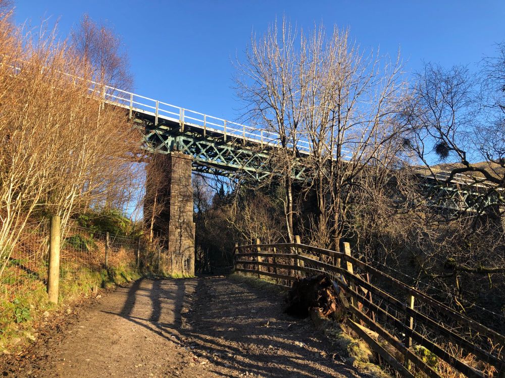
Auchtertyre #viaduct, #Perthshire. Carrying the West Highland #Railway between Tyndrum Upper and Crianlarich.
November 18, 2025 at 1:55 PM
Auchtertyre #viaduct, #Perthshire. Carrying the West Highland #Railway between Tyndrum Upper and Crianlarich.
Poplars, #Herefordshire. There were cattle grazing here as well.

November 11, 2025 at 12:14 PM
Poplars, #Herefordshire. There were cattle grazing here as well.
Pickering Forest 1980. British Relay Championships. #NorthYorkMoors, #EBOR #Orienteering #Maps #OldOrienteeringMaps

November 9, 2025 at 6:53 PM
Pickering Forest 1980. British Relay Championships. #NorthYorkMoors, #EBOR #Orienteering #Maps #OldOrienteeringMaps
Castle Malwood 1980. #NewForest.
Scene of the killing of the Norman king William II. This is the southern edge of the 1980s British Championships area and used as a warm up event.
#OldOrienteeringMaps #Maps #Orienteering #SouthamptonOrienteeringClub #Regicide ?
Scene of the killing of the Norman king William II. This is the southern edge of the 1980s British Championships area and used as a warm up event.
#OldOrienteeringMaps #Maps #Orienteering #SouthamptonOrienteeringClub #Regicide ?

November 5, 2025 at 5:30 PM
Castle Malwood 1980. #NewForest.
Scene of the killing of the Norman king William II. This is the southern edge of the 1980s British Championships area and used as a warm up event.
#OldOrienteeringMaps #Maps #Orienteering #SouthamptonOrienteeringClub #Regicide ?
Scene of the killing of the Norman king William II. This is the southern edge of the 1980s British Championships area and used as a warm up event.
#OldOrienteeringMaps #Maps #Orienteering #SouthamptonOrienteeringClub #Regicide ?
Connel Bridge, #Argyll, #Scotland
Built as a railway bridge and for a while was used by road traffic as well as the railway. Below are the Falls of Lora where the apron at the mouth of a fjord is at sea level, so a waterfall in the sea can form at certain stages at certain stages of the tide.
Built as a railway bridge and for a while was used by road traffic as well as the railway. Below are the Falls of Lora where the apron at the mouth of a fjord is at sea level, so a waterfall in the sea can form at certain stages at certain stages of the tide.

November 5, 2025 at 5:18 PM
Wrekin 1979. E. half of the map which included some very brambly industrial ground on limestone as well as the Uriconian ridge itself. 1st use was for the Midland Championships. This map was for a use up the map stock badge event #OldOrienteeringMaps #Orienteering #Maps #WrekinOrienteers #Shropshire

November 4, 2025 at 5:03 PM
Wrekin 1979. E. half of the map which included some very brambly industrial ground on limestone as well as the Uriconian ridge itself. 1st use was for the Midland Championships. This map was for a use up the map stock badge event #OldOrienteeringMaps #Orienteering #Maps #WrekinOrienteers #Shropshire

King's Garn Gutter #NewForest 1980
British Championships M19 course. Very hot, very runnable.
#OldOrienteeringMaps #Orienteering #Maps #SouthamptonOrienteeringClub
British Championships M19 course. Very hot, very runnable.
#OldOrienteeringMaps #Orienteering #Maps #SouthamptonOrienteeringClub

November 3, 2025 at 1:50 PM
King's Garn Gutter #NewForest 1980
British Championships M19 course. Very hot, very runnable.
#OldOrienteeringMaps #Orienteering #Maps #SouthamptonOrienteeringClub
British Championships M19 course. Very hot, very runnable.
#OldOrienteeringMaps #Orienteering #Maps #SouthamptonOrienteeringClub
Woodland, Craig a Barns, #Perthshire Nov 2nd. Much of the forest above the Cave Pass has been felled. Some survivors here.

November 3, 2025 at 10:19 AM
Woodland, Craig a Barns, #Perthshire Nov 2nd. Much of the forest above the Cave Pass has been felled. Some survivors here.
Cramond, 1980 Cramond to Silverknowes with a photocopied map for an evening event. Mapped by Carol McNeil and others from Dunfermline College, the big black buildings on the west of the area (now houses). #OldOrienteeringMaps #OMaps #Orienteering #ESOC
www.geograph.org.uk/photo/10101
www.geograph.org.uk/photo/10101


November 1, 2025 at 3:42 PM
Cramond, 1980 Cramond to Silverknowes with a photocopied map for an evening event. Mapped by Carol McNeil and others from Dunfermline College, the big black buildings on the west of the area (now houses). #OldOrienteeringMaps #OMaps #Orienteering #ESOC
www.geograph.org.uk/photo/10101
www.geograph.org.uk/photo/10101
Lago Todos Los Santos, Chile

November 1, 2025 at 8:23 AM
Lago Todos Los Santos, Chile
Happendon 1978. Another from the golden age of scribing. I was familiar with the map from Harvey's JK stands. Now only the eastern part is used, it is not possible to cross the motorway that has been built since. #OldOrienteeringMaps, #Orienteering #Lanarkshire


October 31, 2025 at 2:40 PM
Happendon 1978. Another from the golden age of scribing. I was familiar with the map from Harvey's JK stands. Now only the eastern part is used, it is not possible to cross the motorway that has been built since. #OldOrienteeringMaps, #Orienteering #Lanarkshire