


David Oesch
@davidoesch.bsky.social
Geo & Data evangelist. Project Manager by conviction. General knowledge master.
Reposted by David Oesch

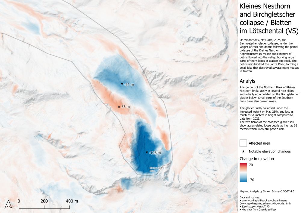
Taking a closer look at the Peak of Kleines Nebelhorn and the collapsed Birchgletscher, the areas of elevation loss become quite evident, with a loss of up to 128 m for the mountain, and 51 m for the glacier.
Some areas show accumulated loose debris which likely poses a risk for further rock slides.
Some areas show accumulated loose debris which likely poses a risk for further rock slides.
June 1, 2025 at 10:10 AM
Taking a closer look at the Peak of Kleines Nebelhorn and the collapsed Birchgletscher, the areas of elevation loss become quite evident, with a loss of up to 128 m for the mountain, and 51 m for the glacier.
Some areas show accumulated loose debris which likely poses a risk for further rock slides.
Some areas show accumulated loose debris which likely poses a risk for further rock slides.
Reposted by David Oesch
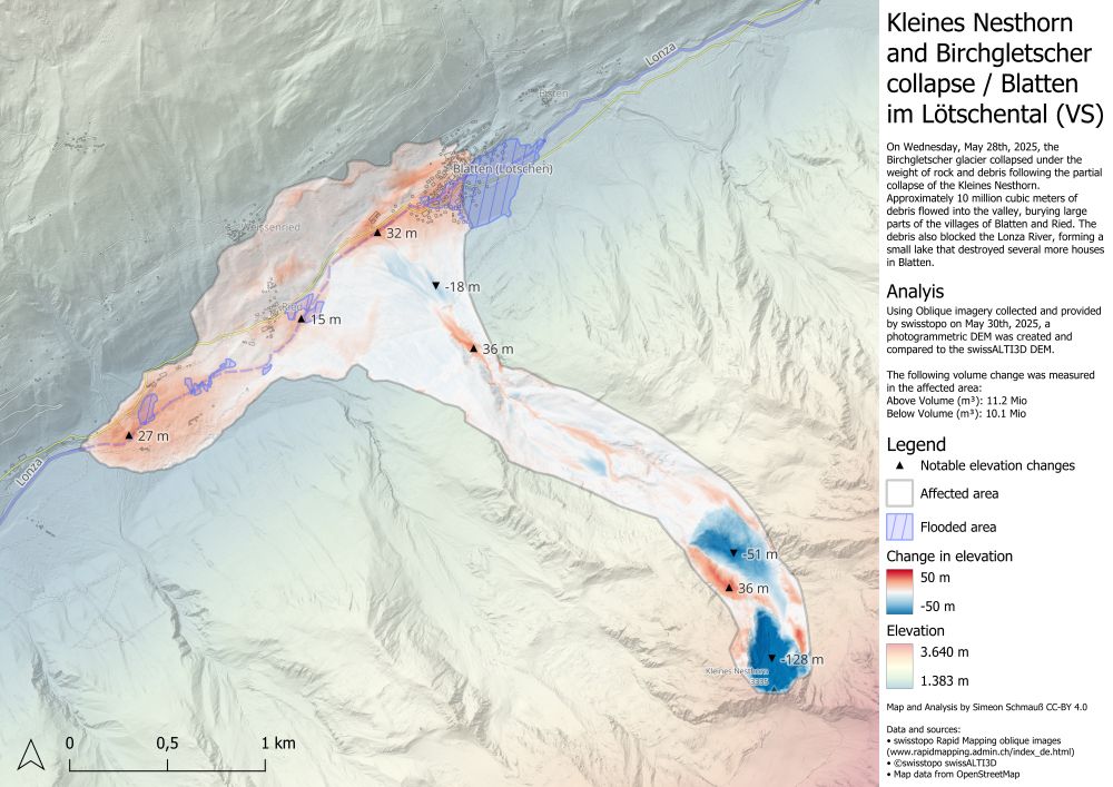
I also derived a new elevation model from the aerial images, allowing me to visualize the elevation change in the affected areas.
The rocks and debris in the valley are locally up to 32m thick and I estimate the total displaced volume is about 11 million cubic meters. #Blatten
The rocks and debris in the valley are locally up to 32m thick and I estimate the total displaced volume is about 11 million cubic meters. #Blatten
June 1, 2025 at 9:39 AM
I also derived a new elevation model from the aerial images, allowing me to visualize the elevation change in the affected areas.
The rocks and debris in the valley are locally up to 32m thick and I estimate the total displaced volume is about 11 million cubic meters. #Blatten
The rocks and debris in the valley are locally up to 32m thick and I estimate the total displaced volume is about 11 million cubic meters. #Blatten
Writing geoparquet —- a one liner with geopandas github.com/swisstopo/to... reading a few lines github.com/swisstopo/to...
topo-satromo/main_functions/main_extract_warnregions.py at 1d8f14fa1179bd05b438ef2836aec567f302a46f · swisstopo/topo-satromo
Erdbeobachtungs-Satellitendaten fürs Trockenheitsmonitoring (SATROMO) - swisstopo/topo-satromo
github.com
March 4, 2025 at 5:58 AM
Writing geoparquet —- a one liner with geopandas github.com/swisstopo/to... reading a few lines github.com/swisstopo/to...
I have 2500 vector datasets as webresource , each of it consisting of 38 polygons/ multipoly . Offered as csv (with separate shp with geom) geojson and geoparquet. Getting the Value of a specific polygon: with geoparquet: streaming does not require a download. …Performance with less code in Python
March 3, 2025 at 6:42 PM
I have 2500 vector datasets as webresource , each of it consisting of 38 polygons/ multipoly . Offered as csv (with separate shp with geom) geojson and geoparquet. Getting the Value of a specific polygon: with geoparquet: streaming does not require a download. …Performance with less code in Python
STAC works perfectly with vector data, and with #cloudnative formats like geoparquet you get your serverless spatial infra . Example of cloudnative raster and vector item is swisstopo Earth. Observation data data.geo.admin.ch/browser/inde... - once you STAC, you never go back .
STAC Browser
data.geo.admin.ch
February 2, 2025 at 2:34 AM
STAC works perfectly with vector data, and with #cloudnative formats like geoparquet you get your serverless spatial infra . Example of cloudnative raster and vector item is swisstopo Earth. Observation data data.geo.admin.ch/browser/inde... - once you STAC, you never go back .
Vorher und nachher
January 2, 2025 at 5:05 PM
Vorher und nachher
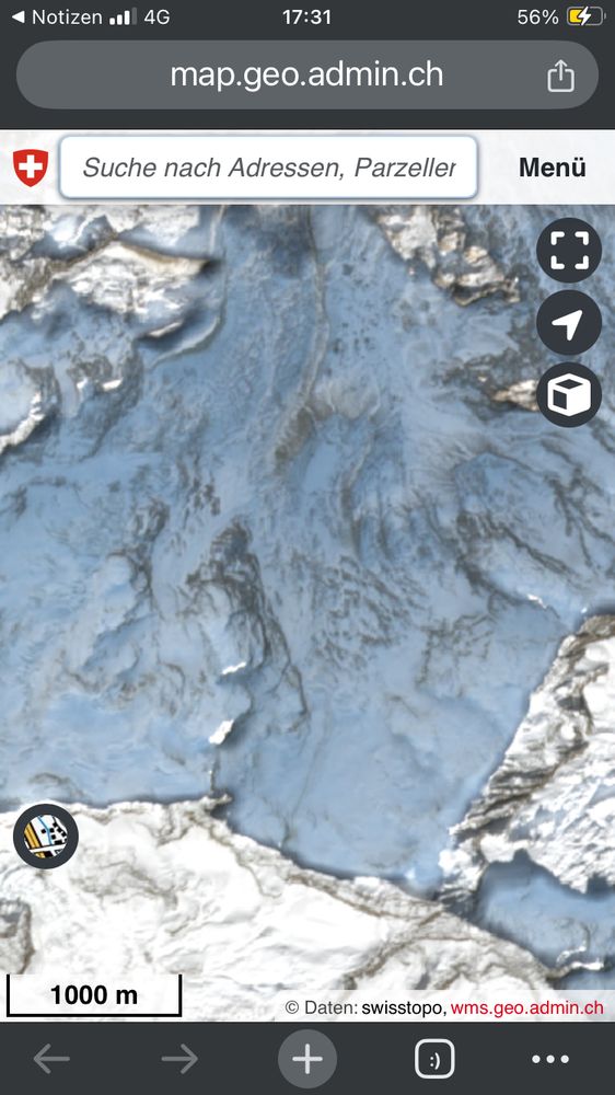
Unter
s.geo.admin.ch/vhmcz9312psy ist ein eindrückliches Satelliten Bild von Sentinel-2 davon zu sehen .
Die Fläche die braun ist beträgt ca 2km2
s.geo.admin.ch/lmjlckikcr5r
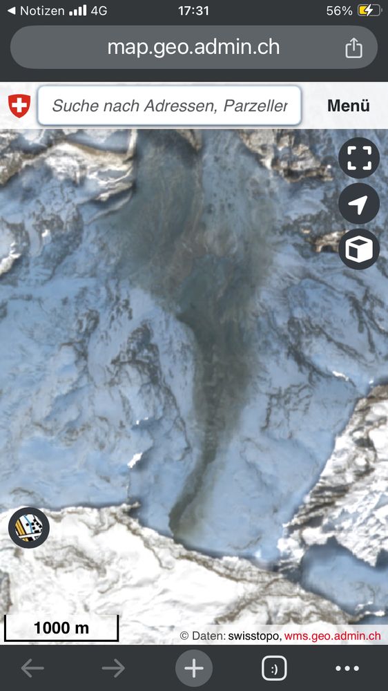
Vorher/ nachher Bild
s.geo.admin.ch/jooffvjvn6k8
Quelle: swisstopo/ Copernicus www.swisstopo.admin.ch/de/satellite...
s.geo.admin.ch/vhmcz9312psy ist ein eindrückliches Satelliten Bild von Sentinel-2 davon zu sehen .
Die Fläche die braun ist beträgt ca 2km2
s.geo.admin.ch/lmjlckikcr5r
Vorher/ nachher Bild
s.geo.admin.ch/jooffvjvn6k8
Quelle: swisstopo/ Copernicus www.swisstopo.admin.ch/de/satellite...
Maps of Switzerland - Swiss Confederation - map.geo.admin.ch
s.geo.admin.ch
January 2, 2025 at 3:49 PM
Unter
s.geo.admin.ch/vhmcz9312psy ist ein eindrückliches Satelliten Bild von Sentinel-2 davon zu sehen .
Die Fläche die braun ist beträgt ca 2km2
s.geo.admin.ch/lmjlckikcr5r
Vorher/ nachher Bild
s.geo.admin.ch/jooffvjvn6k8
Quelle: swisstopo/ Copernicus www.swisstopo.admin.ch/de/satellite...
s.geo.admin.ch/vhmcz9312psy ist ein eindrückliches Satelliten Bild von Sentinel-2 davon zu sehen .
Die Fläche die braun ist beträgt ca 2km2
s.geo.admin.ch/lmjlckikcr5r
Vorher/ nachher Bild
s.geo.admin.ch/jooffvjvn6k8
Quelle: swisstopo/ Copernicus www.swisstopo.admin.ch/de/satellite...
Making of www.linkedin.com/posts/davido...

David Oesch on LinkedIn: Wie viele Briefkästen gibt es? Eine Open-Source-Webanwendung zur Schätzung…
Mit der webapp „Wie viele Briefkästen gibt es?“ ist es möglich die Anzahl der Zustelladressen in einem benutzerdefinierten geografischen Perimeter…
www.linkedin.com
December 22, 2024 at 6:52 PM
Making of www.linkedin.com/posts/davido...
Das limit is der GitHub action runner : 12GB auf dem home directory der Dir zur Verfügung steht. Wie schaffst Du es ein 40Gb pmtiles File herausstellen?
November 25, 2024 at 6:40 PM
Das limit is der GitHub action runner : 12GB auf dem home directory der Dir zur Verfügung steht. Wie schaffst Du es ein 40Gb pmtiles File herausstellen?
Sehr gut gemacht… eigentlich lässt sich damit ein ganzes geoportal mit x Datensätzen betreiben. Hast du schon Erfahrung mit Raster Daten gemacht?
November 25, 2024 at 4:19 PM
Sehr gut gemacht… eigentlich lässt sich damit ein ganzes geoportal mit x Datensätzen betreiben. Hast du schon Erfahrung mit Raster Daten gemacht?
@swisstopo ist auf Insta , x und LinkedIn… werde mal nudgen …
November 22, 2024 at 12:36 PM
@swisstopo ist auf Insta , x und LinkedIn… werde mal nudgen …