


Cyclone Tracking
@cyclonetracking.bsky.social
We are a team of cyclone trackers working together to give you all the latest tropical updates!


Unofficial #HCCTWO
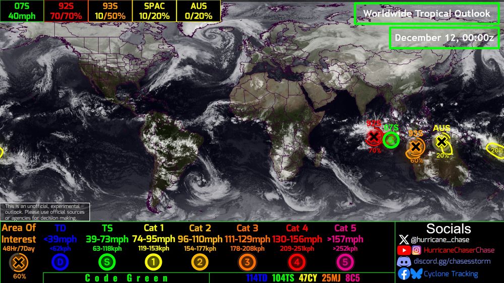
(1) #91S could develop near #Indonesia
(2) A disturbance may threaten #Australia
(3) A disturbance may threaten #Fiji
(4) Something subtropical may form north of #NewZealand
(5) Another signal is emerging near 91S
#wx #cyclone
(1) #91S could develop near #Indonesia
(2) A disturbance may threaten #Australia
(3) A disturbance may threaten #Fiji
(4) Something subtropical may form north of #NewZealand
(5) Another signal is emerging near 91S
#wx #cyclone

December 9, 2025 at 1:09 AM
Unofficial #HCCTWO
(1) #91S could develop near #Indonesia
(2) A disturbance may threaten #Australia
(3) A disturbance may threaten #Fiji
(4) Something subtropical may form north of #NewZealand
(5) Another signal is emerging near 91S
#wx #cyclone
(1) #91S could develop near #Indonesia
(2) A disturbance may threaten #Australia
(3) A disturbance may threaten #Fiji
(4) Something subtropical may form north of #NewZealand
(5) Another signal is emerging near 91S
#wx #cyclone
Unofficial #HCCTWO
(1) #91S could develop near #Indonesia
(2) Something subtropical may form north of #NewZealand
(3) Another system may develop near #Australia
(4) Something may develop and head towards #Fiji
(5) #93W #WilmaPH out of time
#wx #cyclone #typhoon
(1) #91S could develop near #Indonesia
(2) Something subtropical may form north of #NewZealand
(3) Another system may develop near #Australia
(4) Something may develop and head towards #Fiji
(5) #93W #WilmaPH out of time
#wx #cyclone #typhoon

December 8, 2025 at 1:36 AM
Unofficial #HCCTWO
(1) #91S could develop near #Indonesia
(2) Something subtropical may form north of #NewZealand
(3) Another system may develop near #Australia
(4) Something may develop and head towards #Fiji
(5) #93W #WilmaPH out of time
#wx #cyclone #typhoon
(1) #91S could develop near #Indonesia
(2) Something subtropical may form north of #NewZealand
(3) Another system may develop near #Australia
(4) Something may develop and head towards #Fiji
(5) #93W #WilmaPH out of time
#wx #cyclone #typhoon


Invest #93W is continuing to get better organized as it gradually approaches the #Philippines. The storm has been bursting some decent thunderstorms over the past 12 hours and we could see a named system soon. Next Name = #Nokaen #WilmaPH
#typhoon
#typhoon
December 4, 2025 at 12:14 AM
Invest #93W is continuing to get better organized as it gradually approaches the #Philippines. The storm has been bursting some decent thunderstorms over the past 12 hours and we could see a named system soon. Next Name = #Nokaen #WilmaPH
#typhoon
#typhoon

Unfortunately Cyclone #Diwtah's death toll has risen above 465 across #SriLanka. Decided to make a map comparing the fatalities to where the most amount of rain fell. You can see the bullseye of >800mm correlated with the highest fatalities.
#CycloneDitwah #Cyclone
#CycloneDitwah #Cyclone
December 3, 2025 at 1:54 AM
Unfortunately Cyclone #Diwtah's death toll has risen above 465 across #SriLanka. Decided to make a map comparing the fatalities to where the most amount of rain fell. You can see the bullseye of >800mm correlated with the highest fatalities.
#CycloneDitwah #Cyclone
#CycloneDitwah #Cyclone

Unfortunately the death toll only continues to rise from #CycloneSenyar. Decided to make a map showing where the fatalities occurred compared to the track. Just goes to show that you don't need to get a direct hit to see catastrophic impacts.
#cyclone #senyar @pppapin.bsky.social
#cyclone #senyar @pppapin.bsky.social

December 2, 2025 at 2:26 AM
Unfortunately the death toll only continues to rise from #CycloneSenyar. Decided to make a map showing where the fatalities occurred compared to the track. Just goes to show that you don't need to get a direct hit to see catastrophic impacts.
#cyclone #senyar @pppapin.bsky.social
#cyclone #senyar @pppapin.bsky.social

Invest #93W is gradually getting better organized and is beginning to make its southwestward jog towards the #Philippines. Fortunately, it looks like the system will likely not reach #typhoon status. Next Name = #Nokaen #WilmaPH
December 1, 2025 at 6:58 PM
Invest #93W is gradually getting better organized and is beginning to make its southwestward jog towards the #Philippines. Fortunately, it looks like the system will likely not reach #typhoon status. Next Name = #Nokaen #WilmaPH

The Western Pacific now has Invest #93W which is currently located southeast of the Northern Mariana Islands. The system does have a chance to curve out to sea, but it also has a high chance of curving towards the #Philippines. Next Name = #Nokaen #WilmaPH
#typhoon
#typhoon
November 29, 2025 at 3:22 AM
The Western Pacific now has Invest #93W which is currently located southeast of the Northern Mariana Islands. The system does have a chance to curve out to sea, but it also has a high chance of curving towards the #Philippines. Next Name = #Nokaen #WilmaPH
#typhoon
#typhoon
Tropical Storm #Koto is continuing to stall awfully close to #Vietnam, but fortunately none of the outer bands are impacting the country just yet. The system is expected to meander towards the country, where it could make a landfall within the next 4-5 days!
#wx #typhoon
#wx #typhoon
November 29, 2025 at 12:59 AM
