


Colorado Climate Center
@climate.colostate.edu
Climate monitoring, climate research, and climate services for Colorado.
Based at the Department of Atmospheric Science, Colorado State University. https://climate.colostate.edu
Based at the Department of Atmospheric Science, Colorado State University. https://climate.colostate.edu
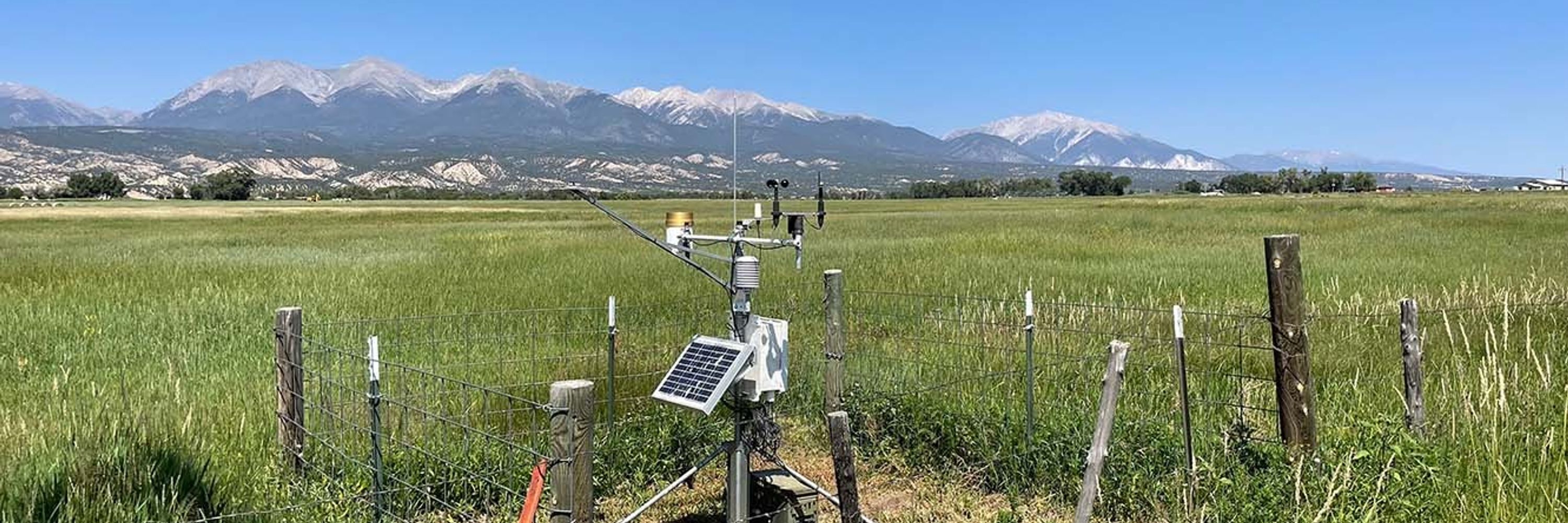
For those unfamiliar, CoAgMET is a network of automated weather stations across Colorado, with real-time data as well as information and tools relevant to agriculture, water resources, and more.
Visit: coagmet.colostate.edu
Visit: coagmet.colostate.edu
November 20, 2025 at 7:44 PM
For those unfamiliar, CoAgMET is a network of automated weather stations across Colorado, with real-time data as well as information and tools relevant to agriculture, water resources, and more.
Visit: coagmet.colostate.edu
Visit: coagmet.colostate.edu
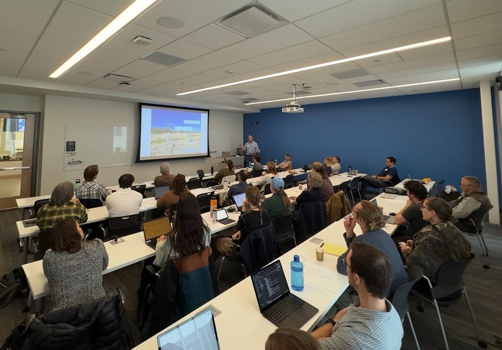
Yesterday, we hosted a meeting for partners and stakeholders of CoAgMET, Colorado's Mesonet. We shared the latest updates and plans, heard ideas for how to make the network even better, and visited the unique station setup on the roof of the Hydro building at the CSU Spur campus in Denver.

November 20, 2025 at 7:44 PM
Yesterday, we hosted a meeting for partners and stakeholders of CoAgMET, Colorado's Mesonet. We shared the latest updates and plans, heard ideas for how to make the network even better, and visited the unique station setup on the roof of the Hydro building at the CSU Spur campus in Denver.
If all this warm and dry November weather has you thinking back to October when there was quite a bit more happening, our monthly summary is for you. Including the big southwest rainstorm and flood, a lack of mountain snow, and more warmth on the Plains:
climate.colostate.edu/monthly_summ... #cowx
climate.colostate.edu/monthly_summ... #cowx

November 13, 2025 at 11:03 PM
If all this warm and dry November weather has you thinking back to October when there was quite a bit more happening, our monthly summary is for you. Including the big southwest rainstorm and flood, a lack of mountain snow, and more warmth on the Plains:
climate.colostate.edu/monthly_summ... #cowx
climate.colostate.edu/monthly_summ... #cowx
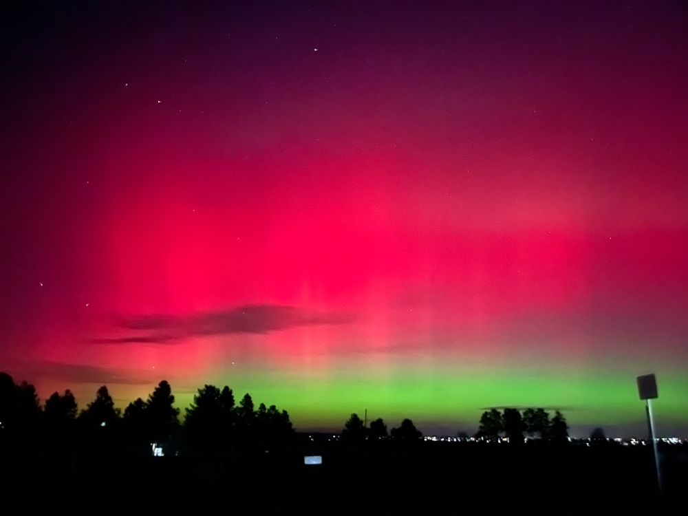
We hope you've been looking up tonight! Here's our view from Fort Collins a little earlier 🌌
November 12, 2025 at 3:50 AM
We hope you've been looking up tonight! Here's our view from Fort Collins a little earlier 🌌
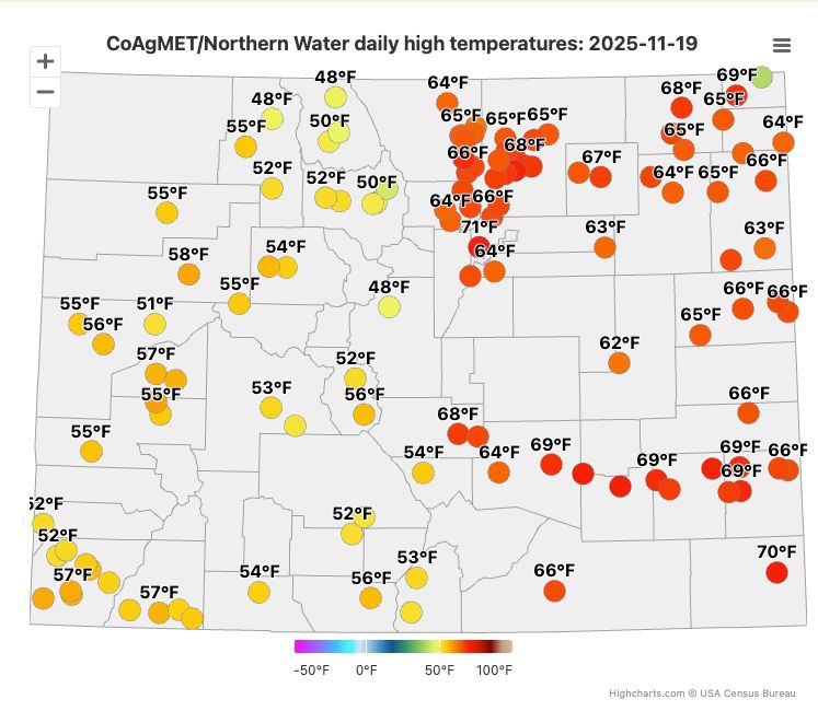
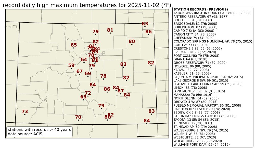
Lots of new daily high temperature records were set across Colorado yesterday, some by more than 5℉! ☀️
November 3, 2025 at 6:55 PM
Lots of new daily high temperature records were set across Colorado yesterday, some by more than 5℉! ☀️
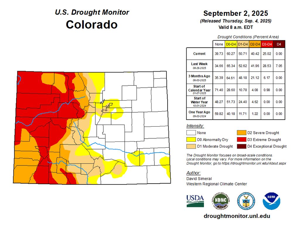
It's been a busy couple of weeks of drought improvements across Colorado! Here's a recap of what's changed in the past two weeks across the state. 🌧️
And ICYMI, check out our previous post for a summary of the remarkable rainfall that brought these major changes to the Drought Monitor.
And ICYMI, check out our previous post for a summary of the remarkable rainfall that brought these major changes to the Drought Monitor.

October 24, 2025 at 7:07 PM
It's been a busy couple of weeks of drought improvements across Colorado! Here's a recap of what's changed in the past two weeks across the state. 🌧️
And ICYMI, check out our previous post for a summary of the remarkable rainfall that brought these major changes to the Drought Monitor.
And ICYMI, check out our previous post for a summary of the remarkable rainfall that brought these major changes to the Drought Monitor.
There were major improvements to this week's drought monitor following the significant precipitation and flooding that impacted western CO over the past week. Changes include two-category improvements over portions of southwest CO, many of which are now drought-free. #cowx

October 16, 2025 at 11:14 PM
There were major improvements to this week's drought monitor following the significant precipitation and flooding that impacted western CO over the past week. Changes include two-category improvements over portions of southwest CO, many of which are now drought-free. #cowx
Follow the ongoing rainstorm in southwestern Colorado with CoAgMET: already nearly an inch of rain today near Durango! #cowx
coagmet.colostate.edu/maps/precip/...
coagmet.colostate.edu/maps/precip/...


October 10, 2025 at 5:07 PM
Follow the ongoing rainstorm in southwestern Colorado with CoAgMET: already nearly an inch of rain today near Durango! #cowx
coagmet.colostate.edu/maps/precip/...
coagmet.colostate.edu/maps/precip/...
And explore the data yourself with these interactive maps: climate.colostate.edu/normals_stn_...


October 7, 2025 at 1:03 PM
And explore the data yourself with these interactive maps: climate.colostate.edu/normals_stn_...
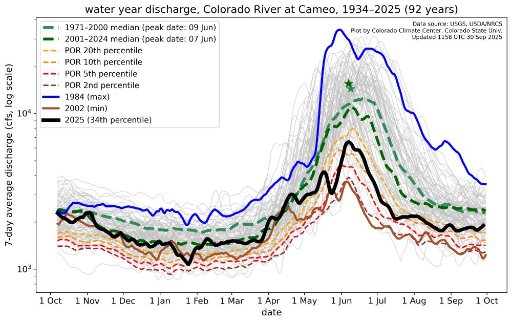
The water year also aligns nicely with patterns in streamflow. It captures the gradual increase in runoff throughout the spring, followed by summertime peak, then the gradual decline in late summer/early fall. [6/7]
October 1, 2025 at 11:05 PM
The water year also aligns nicely with patterns in streamflow. It captures the gradual increase in runoff throughout the spring, followed by summertime peak, then the gradual decline in late summer/early fall. [6/7]
Starting the water year on Oct 1 means we account for most (if not all) of the winter snowpack.
This graph of water year snow water equivalent (SWE) at Fremont Pass shows this well. Look how much water would be unaccounted for during the spring runoff if we only started counting on Jan 1! [5/7]
This graph of water year snow water equivalent (SWE) at Fremont Pass shows this well. Look how much water would be unaccounted for during the spring runoff if we only started counting on Jan 1! [5/7]

October 1, 2025 at 11:05 PM
Starting the water year on Oct 1 means we account for most (if not all) of the winter snowpack.
This graph of water year snow water equivalent (SWE) at Fremont Pass shows this well. Look how much water would be unaccounted for during the spring runoff if we only started counting on Jan 1! [5/7]
This graph of water year snow water equivalent (SWE) at Fremont Pass shows this well. Look how much water would be unaccounted for during the spring runoff if we only started counting on Jan 1! [5/7]
If you're familiar with Colorado, or even the West more generally, you're probably aware that our winter snowpack is the biggest contributor to our warm season water supply.
This snowpack starts to build in the fall (long before the start of the calendar year). [4/7]
This snowpack starts to build in the fall (long before the start of the calendar year). [4/7]

October 1, 2025 at 11:05 PM
If you're familiar with Colorado, or even the West more generally, you're probably aware that our winter snowpack is the biggest contributor to our warm season water supply.
This snowpack starts to build in the fall (long before the start of the calendar year). [4/7]
This snowpack starts to build in the fall (long before the start of the calendar year). [4/7]
But why begin tracking the movement of water in October?
A big reason for offsetting the water year from the calendar year is so that we can properly budget how much winter precipitation will be available for the following runoff season. [3/7]
A big reason for offsetting the water year from the calendar year is so that we can properly budget how much winter precipitation will be available for the following runoff season. [3/7]

October 1, 2025 at 11:05 PM
But why begin tracking the movement of water in October?
A big reason for offsetting the water year from the calendar year is so that we can properly budget how much winter precipitation will be available for the following runoff season. [3/7]
A big reason for offsetting the water year from the calendar year is so that we can properly budget how much winter precipitation will be available for the following runoff season. [3/7]
Only some of this precipitation was incorporated in this week's U.S. Drought Monitor (the weekly data cutoff is Tuesdays at 6am MDT). Nonetheless, we still saw some drought improvements throughout the state this week! 🌧️

September 25, 2025 at 2:28 PM
Only some of this precipitation was incorporated in this week's U.S. Drought Monitor (the weekly data cutoff is Tuesdays at 6am MDT). Nonetheless, we still saw some drought improvements throughout the state this week! 🌧️
Yesterday was the wettest day in quite some time for northeastern Colorado. Widespread observations of over 1" of rain, and over 2" in some spots on the Plains.
Several inches of snow in the mountains too!
Map from coagmet.colostate.edu #cowx
Several inches of snow in the mountains too!
Map from coagmet.colostate.edu #cowx

September 24, 2025 at 3:23 PM
Yesterday was the wettest day in quite some time for northeastern Colorado. Widespread observations of over 1" of rain, and over 2" in some spots on the Plains.
Several inches of snow in the mountains too!
Map from coagmet.colostate.edu #cowx
Several inches of snow in the mountains too!
Map from coagmet.colostate.edu #cowx
9/18 Drought Update 🌵: We saw more beneficial precipitation last week, which prompted widespread improvements in western and southern Colorado in this week's US Drought Monitor. Good news for now, but we'll need additional moisture to continue chipping away at those longer-term deficits.

September 18, 2025 at 9:18 PM
9/18 Drought Update 🌵: We saw more beneficial precipitation last week, which prompted widespread improvements in western and southern Colorado in this week's US Drought Monitor. Good news for now, but we'll need additional moisture to continue chipping away at those longer-term deficits.
August Recap ⏪: Hot, dry conditions intensified drought and fanned wildfires across western Colorado, but monsoon moisture finally delivered some much-needed precipitation at the end of the month. Just how significant was that rainfall? All that and more in our monthly climate summary! col.st/STpEm

September 10, 2025 at 5:34 PM
August Recap ⏪: Hot, dry conditions intensified drought and fanned wildfires across western Colorado, but monsoon moisture finally delivered some much-needed precipitation at the end of the month. Just how significant was that rainfall? All that and more in our monthly climate summary! col.st/STpEm
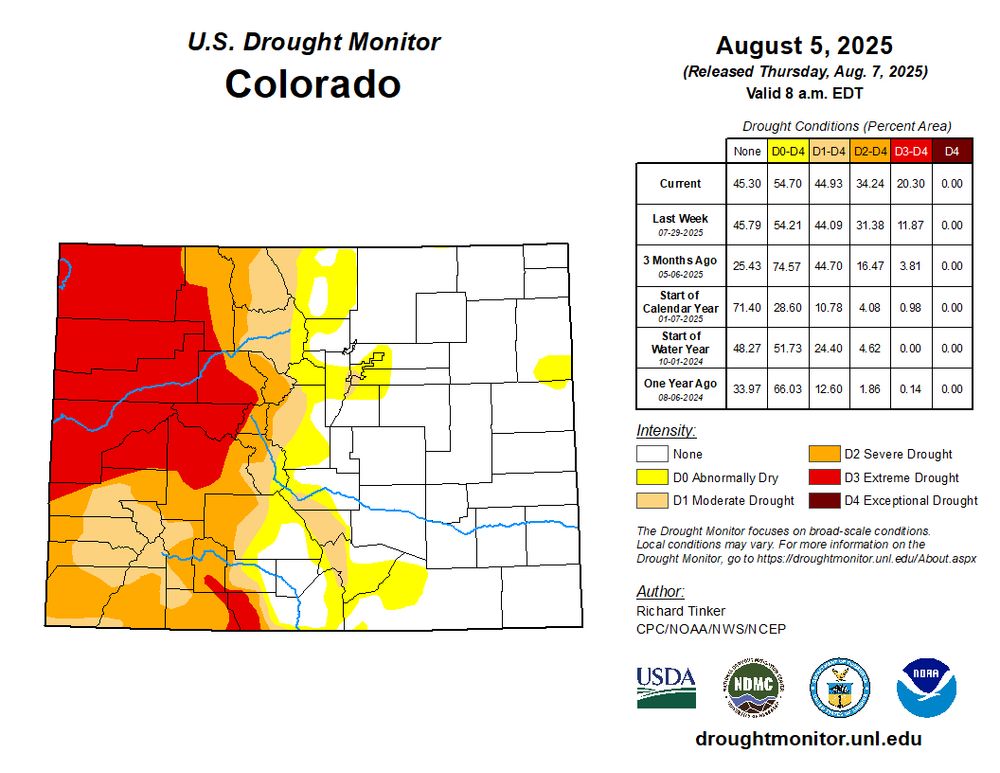
Last week's sorely needed rain across western Colorado was enough to remove the D4 (exceptional) drought in the northwest. Still, though, 25% of the state is in D3 (extreme) drought, with very large precipitation deficits going back to the beginning of the year. #cowx climate.colostate.edu/drought/

September 4, 2025 at 1:53 PM
Last week's sorely needed rain across western Colorado was enough to remove the D4 (exceptional) drought in the northwest. Still, though, 25% of the state is in D3 (extreme) drought, with very large precipitation deficits going back to the beginning of the year. #cowx climate.colostate.edu/drought/
Greetings from the Colorado Water Congress summer conference in beautiful (but dry) Steamboat Springs. We’re discussing our work with CoAgMET and especially the effort to improve soil moisture monitoring across Colorado!

August 20, 2025 at 2:13 PM
Greetings from the Colorado Water Congress summer conference in beautiful (but dry) Steamboat Springs. We’re discussing our work with CoAgMET and especially the effort to improve soil moisture monitoring across Colorado!
Finally, a pattern change on the way for western Colorado! Model forecasts of precipitable water (total water vapor in the atmosphere) at Grand Junction show more hot and dry this week, but then some real moisture next wk. Too early to say how much rain or drought relief, but a welcome sight.🤞 #cowx


August 18, 2025 at 1:43 PM
Finally, a pattern change on the way for western Colorado! Model forecasts of precipitable water (total water vapor in the atmosphere) at Grand Junction show more hot and dry this week, but then some real moisture next wk. Too early to say how much rain or drought relief, but a welcome sight.🤞 #cowx
The D4 (exceptional) category was added to this week's US Drought Monitor in northwest Colorado, amid a lack of spring and summer precipitation, fast-growing wildfires, and low streamflow. It's the first D4 in the state since January 2023, and the first D4 west of the divide since Oct 2021. #cowx

August 14, 2025 at 2:03 PM
The D4 (exceptional) category was added to this week's US Drought Monitor in northwest Colorado, amid a lack of spring and summer precipitation, fast-growing wildfires, and low streamflow. It's the first D4 in the state since January 2023, and the first D4 west of the divide since Oct 2021. #cowx

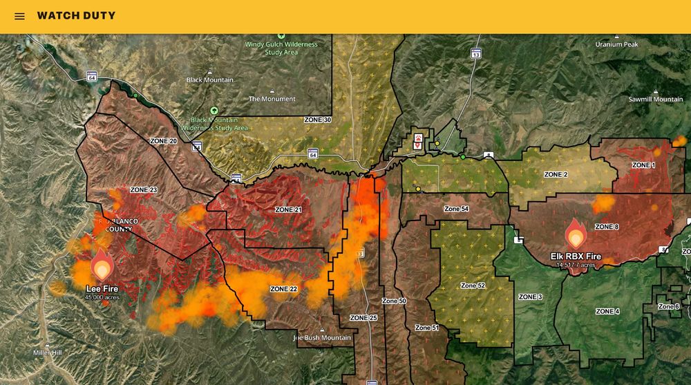
This week's US Drought Monitor shows continued expansion of extreme drought in northwestern Colorado. Over 20% of the state is now in D3. Large fires continue to grow in drought-stricken areas, with the Lee Fire near Meeker now at 45,000 acres, with more hot, dry, and windy weather today. #cowx
August 7, 2025 at 3:05 PM
This week's US Drought Monitor shows continued expansion of extreme drought in northwestern Colorado. Over 20% of the state is now in D3. Large fires continue to grow in drought-stricken areas, with the Lee Fire near Meeker now at 45,000 acres, with more hot, dry, and windy weather today. #cowx
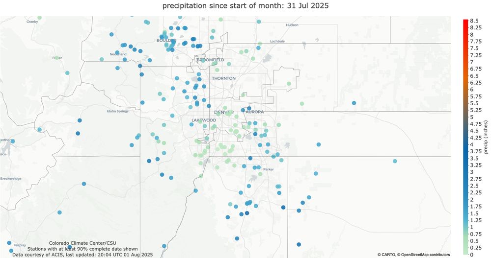
July rainfall had some huge variations across the Denver metro area. From downtown southward to Littleton, many stations with less than 0.25" for the month. But over 2.5" in parts of Aurora and Centennial. Thanks to all the CoCoRaHS observers for enabling such a detailed map! #cowx
August 1, 2025 at 9:05 PM
July rainfall had some huge variations across the Denver metro area. From downtown southward to Littleton, many stations with less than 0.25" for the month. But over 2.5" in parts of Aurora and Centennial. Thanks to all the CoCoRaHS observers for enabling such a detailed map! #cowx
Custer County is not a typical place for overlapping tornado and flash flood warnings! A tornado was observed southwest of Westcliffe this afternoon. The tornado warning has since expired, but the flash flood warning continues.
It's the first tornado report in Custer County since 2019. #cowx
It's the first tornado report in Custer County since 2019. #cowx
July 30, 2025 at 9:41 PM
Custer County is not a typical place for overlapping tornado and flash flood warnings! A tornado was observed southwest of Westcliffe this afternoon. The tornado warning has since expired, but the flash flood warning continues.
It's the first tornado report in Custer County since 2019. #cowx
It's the first tornado report in Custer County since 2019. #cowx