


The Cartography and Geographic Information Society
@carto-giscience.bsky.social
The Cartography and Geographic Information Society supports research, education, and practice to improve the understanding, creation, analysis, and use of maps and geographic information to support effective decision-making and improve the quality of life.
New article! Nianhua Liu, Yu Feng and colleagues look at Trust in Climate Change Communication, including the impact of having just a map or a photo included, or just a headline #GISchat #OpenAccess doi.org/10.1080/1523... Data at figshare.com/articles/dat...

February 3, 2026 at 3:49 PM
New article! Nianhua Liu, Yu Feng and colleagues look at Trust in Climate Change Communication, including the impact of having just a map or a photo included, or just a headline #GISchat #OpenAccess doi.org/10.1080/1523... Data at figshare.com/articles/dat...
New article! Manuel Riberio and colleagues use Web-Delphi and workshops to help develop map-based dashboards to support pandemic response policy-making #GISchat doi.org/10.1080/1523...

February 2, 2026 at 3:42 PM
New article! Manuel Riberio and colleagues use Web-Delphi and workshops to help develop map-based dashboards to support pandemic response policy-making #GISchat doi.org/10.1080/1523...
New paper! Muhammet Ali Heyik & Francisco J. Abarca-Álvarez investigate implement thick mapping in spatial design studios, providing greater understanding of complex processes and spatial understanding in complex urban environments doi.org/10.1080/1523... #GISchat

January 12, 2026 at 4:42 PM
New paper! Muhammet Ali Heyik & Francisco J. Abarca-Álvarez investigate implement thick mapping in spatial design studios, providing greater understanding of complex processes and spatial understanding in complex urban environments doi.org/10.1080/1523... #GISchat
New article! Wenbo Zhang and colleagues employ a Parameter-Efficient Fine-Tuning (PEFT) strategy to improve automated map generating using AI: MapGenerator #GISchat doi.org/10.1080/1523...

January 5, 2026 at 3:14 PM
New article! Wenbo Zhang and colleagues employ a Parameter-Efficient Fine-Tuning (PEFT) strategy to improve automated map generating using AI: MapGenerator #GISchat doi.org/10.1080/1523...
New article! Chaun Chen, Mengyi Wei and colleagues look at GeoAI ethics and present An infographic framework of GeoAI ethics based on news data #GISchat #OpenAccess doi.org/10.1080/1523...

December 19, 2025 at 2:38 PM
New article! Chaun Chen, Mengyi Wei and colleagues look at GeoAI ethics and present An infographic framework of GeoAI ethics based on news data #GISchat #OpenAccess doi.org/10.1080/1523...
New article! Tomasz Opach and colleagues explore using a digital map to facilitate the exploration of place names from literary, using place names mentioned in Norwegian literature 1814–1905 doi.org/10.1080/1523... #GISchat

December 18, 2025 at 1:55 PM
New article! Tomasz Opach and colleagues explore using a digital map to facilitate the exploration of place names from literary, using place names mentioned in Norwegian literature 1814–1905 doi.org/10.1080/1523... #GISchat
The final paper in our upcoming special issue on #Replicability and #Reproducibility, Joseph Holler and colleagues use open science practices to develop a GIScience study on access t oCOVID-19 healthcare in Illinois, US doi.org/10.1080/1523... #OpenAccess #GISchat

December 15, 2025 at 4:19 PM
The final paper in our upcoming special issue on #Replicability and #Reproducibility, Joseph Holler and colleagues use open science practices to develop a GIScience study on access t oCOVID-19 healthcare in Illinois, US doi.org/10.1080/1523... #OpenAccess #GISchat
New article! How do we go about using AI to automate point symbol generation? Shuaiqing Wang, Li Shen and colleagues have a investigate, with the process and an example shown below doi.org/10.1080/1523... Data and code at doi.org/10.6084/m9.f... #GISchat


December 11, 2025 at 4:25 PM
New article! How do we go about using AI to automate point symbol generation? Shuaiqing Wang, Li Shen and colleagues have a investigate, with the process and an example shown below doi.org/10.1080/1523... Data and code at doi.org/10.6084/m9.f... #GISchat
Deepfake geography: A new paper from Valentin Meo looking at how we can detect manipulated satellite images doi.org/10.1080/1523...
Also check out our interview on the paper with Valentin and
@nickbearman.bsky.social: youtu.be/DklnevrHR1c #GISchat #FreeAccess
Also check out our interview on the paper with Valentin and
@nickbearman.bsky.social: youtu.be/DklnevrHR1c #GISchat #FreeAccess
December 10, 2025 at 3:17 PM
Deepfake geography: A new paper from Valentin Meo looking at how we can detect manipulated satellite images doi.org/10.1080/1523...
Also check out our interview on the paper with Valentin and
@nickbearman.bsky.social: youtu.be/DklnevrHR1c #GISchat #FreeAccess
Also check out our interview on the paper with Valentin and
@nickbearman.bsky.social: youtu.be/DklnevrHR1c #GISchat #FreeAccess
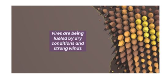
New article! Using storytelling and guided interactions to help users understand large spatial and temporal data sets. Oana Candit et al. provide an example representing active fires of 2023 Paper: doi.org/10.1080/1523... App: www.animation.oanacanditmaps.ro/app/ #GISchat
December 8, 2025 at 4:30 PM
New article! Using storytelling and guided interactions to help users understand large spatial and temporal data sets. Oana Candit et al. provide an example representing active fires of 2023 Paper: doi.org/10.1080/1523... App: www.animation.oanacanditmaps.ro/app/ #GISchat
New paper! Thomas Depian et al. investigate transitions in dynamic point labelling which are an issue in dynamic mapping systems. Weather data in Vienna - the labels change and it is not obvious which have changed doi.org/10.1080/1523... #GISchat #OpenAccess doi.org/10.17605/OSF...

December 3, 2025 at 3:59 PM
New paper! Thomas Depian et al. investigate transitions in dynamic point labelling which are an issue in dynamic mapping systems. Weather data in Vienna - the labels change and it is not obvious which have changed doi.org/10.1080/1523... #GISchat #OpenAccess doi.org/10.17605/OSF...
New article! Timofey Samsonov explores animated transitions proportional symbol and choropleth representations on thematic maps #GISchat #ICC2023 doi.org/10.1080/1523... Check out the supplementary videos of each transition at zenodo.org/records/1717... and see it in practice at observablehq.com

December 2, 2025 at 11:57 AM
New article! Timofey Samsonov explores animated transitions proportional symbol and choropleth representations on thematic maps #GISchat #ICC2023 doi.org/10.1080/1523... Check out the supplementary videos of each transition at zenodo.org/records/1717... and see it in practice at observablehq.com
We all know color in maps is important. Shangjing Jiang and colleagues used crowdsourced photographs to create place-aware colored maps which help create a sense of place doi.org/10.1080/1523... #GISchat Figure 1 below shows their comparisons: Google Maps, Snazzy Maps "Hopper" and place-aware maps

December 1, 2025 at 11:51 AM
We all know color in maps is important. Shangjing Jiang and colleagues used crowdsourced photographs to create place-aware colored maps which help create a sense of place doi.org/10.1080/1523... #GISchat Figure 1 below shows their comparisons: Google Maps, Snazzy Maps "Hopper" and place-aware maps
At a festival with events happening over a week and over a whole city? Dilara Bozkurt explores temporal navigation for festival maps on mobile devices, working out how to incorporate space and time on a small screen like a mobile phone doi.org/10.1080/1523... #GISchat #OpenAccess Check out the GIF:
November 27, 2025 at 3:02 PM
At a festival with events happening over a week and over a whole city? Dilara Bozkurt explores temporal navigation for festival maps on mobile devices, working out how to incorporate space and time on a small screen like a mobile phone doi.org/10.1080/1523... #GISchat #OpenAccess Check out the GIF:
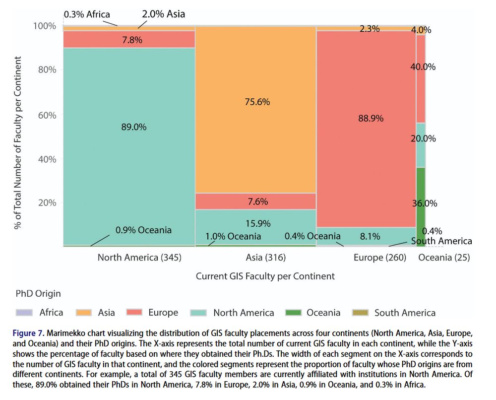
New article! Where are GIScience faculty hired from? Yanbing Chen and colleagues, using data from GISphere, analyze faculty mobility and research themes through hiring networks #GISchat doi.org/10.1080/1523... Below: where current GIS faculty are (x-axis) and where they got their PhDs (y-axis).
November 25, 2025 at 11:55 AM
New article! Where are GIScience faculty hired from? Yanbing Chen and colleagues, using data from GISphere, analyze faculty mobility and research themes through hiring networks #GISchat doi.org/10.1080/1523... Below: where current GIS faculty are (x-axis) and where they got their PhDs (y-axis).
Fantastic article on Georeferencing historical maps using automated processes, including local feature matching and Delaunay consistency from Beatrice Vaienti, Isabella di Lenardo and Frédéric Kaplan doi.org/10.1080/1523... #GISchat #OpenAccess


November 24, 2025 at 4:50 PM
Fantastic article on Georeferencing historical maps using automated processes, including local feature matching and Delaunay consistency from Beatrice Vaienti, Isabella di Lenardo and Frédéric Kaplan doi.org/10.1080/1523... #GISchat #OpenAccess
New paper from Hong Wang, Mingda Zhang and colleagues: Evaluating color preference in thematic maps, a case study from China doi.org/10.1080/1523... #GISchat See below, figure 12: The true and predicted values of a selection of maps, with higher values for better maps.

November 20, 2025 at 3:13 PM
New paper from Hong Wang, Mingda Zhang and colleagues: Evaluating color preference in thematic maps, a case study from China doi.org/10.1080/1523... #GISchat See below, figure 12: The true and predicted values of a selection of maps, with higher values for better maps.
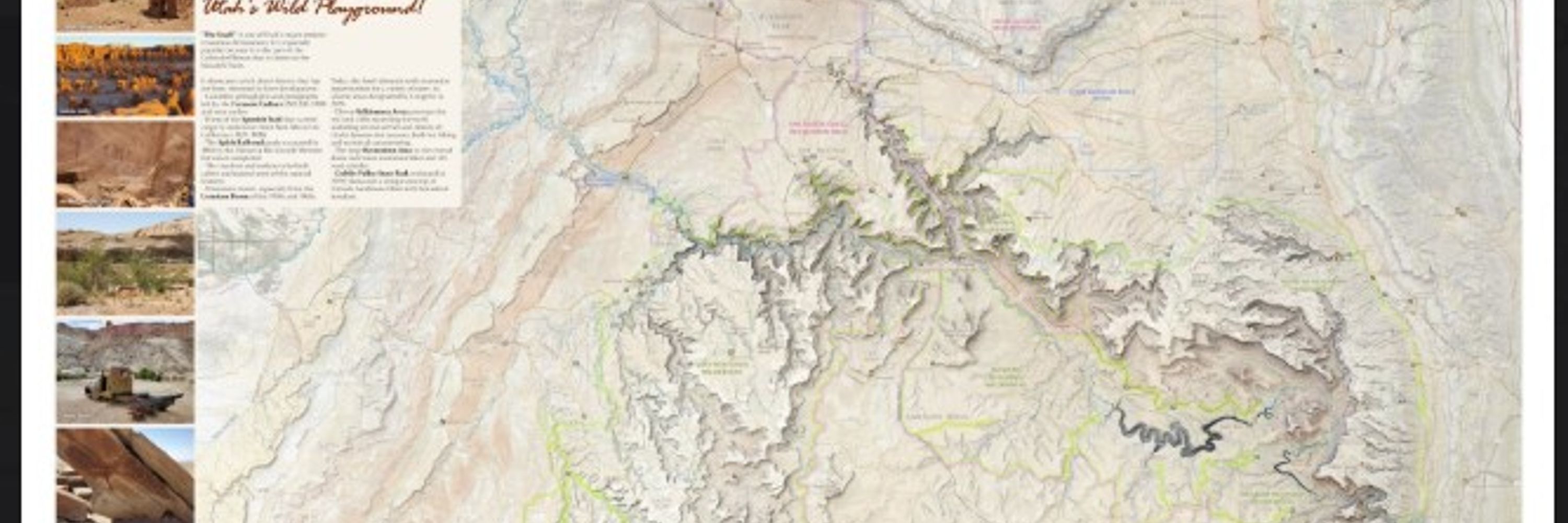
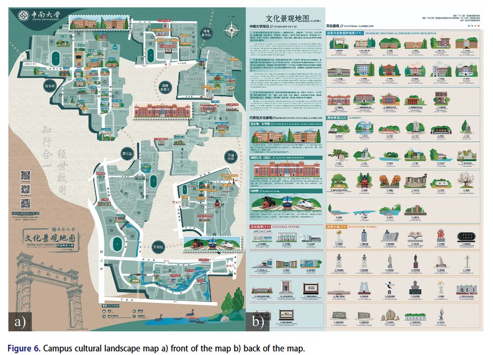
How to design a campus cultural landscape map? Tao Zou and colleagues designed a map and then explored the user experience of the map doi.org/10.1080/1523... #GISchat Check out their map below, and the full res version at figshare.com/articles/dat...
November 19, 2025 at 4:37 PM
How to design a campus cultural landscape map? Tao Zou and colleagues designed a map and then explored the user experience of the map doi.org/10.1080/1523... #GISchat Check out their map below, and the full res version at figshare.com/articles/dat...
Deepfake geography: A new paper from Valentin Meo looking at how we can detect manipulated satellite images doi.org/10.1080/1523... Also check out our interview on the paper with Valentin and @nickbearman.bsky.social: youtu.be/DklnevrHR1c #GISchat #FreeAccess

November 17, 2025 at 2:30 PM
Deepfake geography: A new paper from Valentin Meo looking at how we can detect manipulated satellite images doi.org/10.1080/1523... Also check out our interview on the paper with Valentin and @nickbearman.bsky.social: youtu.be/DklnevrHR1c #GISchat #FreeAccess
Issue 52-6 of Cartography and Geographic Information Science is now available!
We have 8 papers, inc. navigation, symbology, schematic representations of roads maps, labelling, Swiss style relief shading maps and a thank you to our reviewers!
www.tandfonline.com/toc/tcag20/5... #GISchat
We have 8 papers, inc. navigation, symbology, schematic representations of roads maps, labelling, Swiss style relief shading maps and a thank you to our reviewers!
www.tandfonline.com/toc/tcag20/5... #GISchat

November 12, 2025 at 11:03 AM
Issue 52-6 of Cartography and Geographic Information Science is now available!
We have 8 papers, inc. navigation, symbology, schematic representations of roads maps, labelling, Swiss style relief shading maps and a thank you to our reviewers!
www.tandfonline.com/toc/tcag20/5... #GISchat
We have 8 papers, inc. navigation, symbology, schematic representations of roads maps, labelling, Swiss style relief shading maps and a thank you to our reviewers!
www.tandfonline.com/toc/tcag20/5... #GISchat
New article! Darlan Miranda Nunes & Silvana Philippi Camboim investigate Collaborative toponyms in OpenStreetMap evaluating the potential to complement and update National Mapping Agencies data, doi.org/10.1080/1523... also see their code and process at github.com/darlanmnunes...
#GISchat
#GISchat

November 5, 2025 at 3:03 PM
New article! Darlan Miranda Nunes & Silvana Philippi Camboim investigate Collaborative toponyms in OpenStreetMap evaluating the potential to complement and update National Mapping Agencies data, doi.org/10.1080/1523... also see their code and process at github.com/darlanmnunes...
#GISchat
#GISchat
New paper! Fascinating discussion of Optimizing electric vehicle supply equipment allocation using a range of local and global MCDA methods by Emily Zhou & Junyi Yang, #GISchat doi.org/10.1080/1523...

November 4, 2025 at 3:06 PM
New paper! Fascinating discussion of Optimizing electric vehicle supply equipment allocation using a range of local and global MCDA methods by Emily Zhou & Junyi Yang, #GISchat doi.org/10.1080/1523...
New article! Fascinating article on the impact personal narratives have on making thematic maps more persuasive by Rob Davidson and James Cheshire, doi.org/10.1080/1523... #OpenAccess #GISChat

Do personal narratives make thematic maps more persuasive? Integrating concrete examples into maps of the social determinants of health
Thematic maps about social inequalities can engage audiences, add context to policy debates, and change attitudes toward the issues. The field of communication has long compared the relative persua...
doi.org
November 3, 2025 at 3:12 PM
New article! Fascinating article on the impact personal narratives have on making thematic maps more persuasive by Rob Davidson and James Cheshire, doi.org/10.1080/1523... #OpenAccess #GISChat
Fantastic new article from Lars De Sloover and colleagues from Department of Ggeography Ugent comparing impacts of Euclidean distance and dynamic time warping with spatiotemporal analysis of COVID-19 dynamics across Europe #GISchat doi.org/10.1080/1523...


October 16, 2025 at 4:33 PM
Fantastic new article from Lars De Sloover and colleagues from Department of Ggeography Ugent comparing impacts of Euclidean distance and dynamic time warping with spatiotemporal analysis of COVID-19 dynamics across Europe #GISchat doi.org/10.1080/1523...
Reposted by The Cartography and Geographic Information Society

Thrilled to share Exploropleth - our new #GIS #dataviz tool.
💡 @Mapmakers, you can simultaneously explore & compare 16+ data binning methods on a choropleth map, directly in your browser!
🎓 @Instructors, you can use the tool to teach how choropleth maps can mislead people!
exploropleth.github.io
💡 @Mapmakers, you can simultaneously explore & compare 16+ data binning methods on a choropleth map, directly in your browser!
🎓 @Instructors, you can use the tool to teach how choropleth maps can mislead people!
exploropleth.github.io

October 14, 2025 at 11:39 AM
Thrilled to share Exploropleth - our new #GIS #dataviz tool.
💡 @Mapmakers, you can simultaneously explore & compare 16+ data binning methods on a choropleth map, directly in your browser!
🎓 @Instructors, you can use the tool to teach how choropleth maps can mislead people!
exploropleth.github.io
💡 @Mapmakers, you can simultaneously explore & compare 16+ data binning methods on a choropleth map, directly in your browser!
🎓 @Instructors, you can use the tool to teach how choropleth maps can mislead people!
exploropleth.github.io