


Brad Storm Chaser
@bradstorm19.bsky.social
I love weather and storms.
Reposted by Brad Storm Chaser

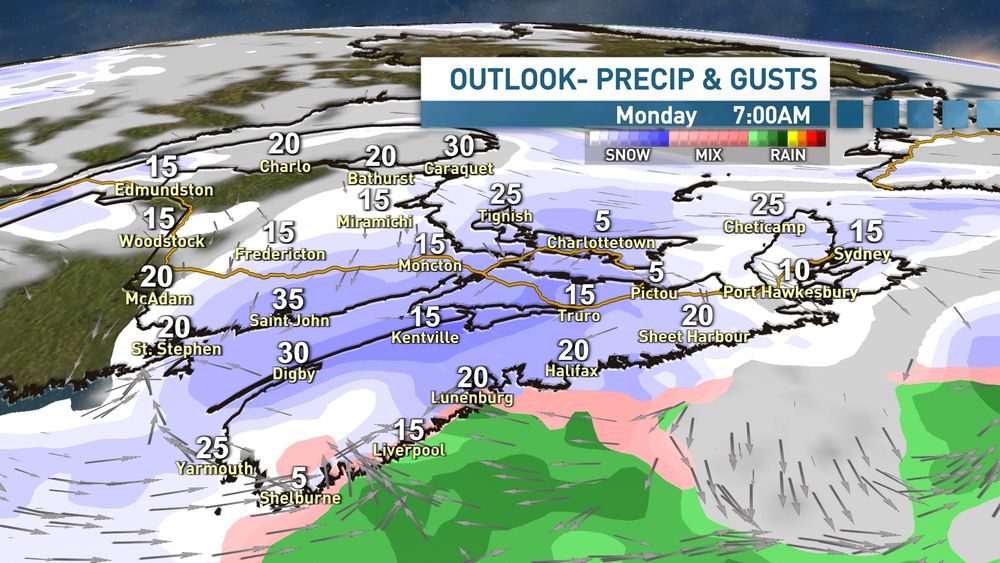
Cold west winds triggering a heavy snow squall along Fundy and north shores NS. Will weaken & move a bit inland this aftn.
Otherwise fine sun-cloud mix.
A weak band mixed precip Sat night-Sunday am (no pic).
A system passing south of NS brings snow (5-10cm?) Sunday night to southern Maritimes.
Otherwise fine sun-cloud mix.
A weak band mixed precip Sat night-Sunday am (no pic).
A system passing south of NS brings snow (5-10cm?) Sunday night to southern Maritimes.

December 12, 2025 at 12:04 PM
Cold west winds triggering a heavy snow squall along Fundy and north shores NS. Will weaken & move a bit inland this aftn.
Otherwise fine sun-cloud mix.
A weak band mixed precip Sat night-Sunday am (no pic).
A system passing south of NS brings snow (5-10cm?) Sunday night to southern Maritimes.
Otherwise fine sun-cloud mix.
A weak band mixed precip Sat night-Sunday am (no pic).
A system passing south of NS brings snow (5-10cm?) Sunday night to southern Maritimes.


Reposted by Brad Storm Chaser


Reposted by Brad Storm Chaser
Rain has moved into eastern NS & E PEI; just a few showers further west(flurries N NB). Rain tapers to a few showers this aftn (wet flurries NB). A colder westerly wind develops; onshore snow most likely Fundy & Strait shores (pic).
Next system passes S NS later Sunday. Seems CB best chance 10+cm.
Next system passes S NS later Sunday. Seems CB best chance 10+cm.

December 11, 2025 at 11:51 AM
Rain has moved into eastern NS & E PEI; just a few showers further west(flurries N NB). Rain tapers to a few showers this aftn (wet flurries NB). A colder westerly wind develops; onshore snow most likely Fundy & Strait shores (pic).
Next system passes S NS later Sunday. Seems CB best chance 10+cm.
Next system passes S NS later Sunday. Seems CB best chance 10+cm.
Reposted by Brad Storm Chaser
Bands of patchy snow (few cm) this morning changing/mixed with rain in NS this aftn.
Snow moves into NB this eve then rain over all 3 provinces (xcp N NB) tonight. Rain tapers to showers Thursday then colder with onshore snow Friday.
System passes south late Sunday threatens mostly NS with snow.
Snow moves into NB this eve then rain over all 3 provinces (xcp N NB) tonight. Rain tapers to showers Thursday then colder with onshore snow Friday.
System passes south late Sunday threatens mostly NS with snow.

December 10, 2025 at 12:13 PM
Bands of patchy snow (few cm) this morning changing/mixed with rain in NS this aftn.
Snow moves into NB this eve then rain over all 3 provinces (xcp N NB) tonight. Rain tapers to showers Thursday then colder with onshore snow Friday.
System passes south late Sunday threatens mostly NS with snow.
Snow moves into NB this eve then rain over all 3 provinces (xcp N NB) tonight. Rain tapers to showers Thursday then colder with onshore snow Friday.
System passes south late Sunday threatens mostly NS with snow.
Reposted by Brad Storm Chaser
Lots of chilly sunshine today (remnant onshore snow Miscou to Cheticamp).
A narrow band or snow north/rain south crosses Wednesday. Then snow (10-15cm north; 5-10cm south) moves to NB Wed evening. Rainy over Maritimes by Thursday morning.
Colder & windy with onshore snow Friday.
Messy late Sunday.
A narrow band or snow north/rain south crosses Wednesday. Then snow (10-15cm north; 5-10cm south) moves to NB Wed evening. Rainy over Maritimes by Thursday morning.
Colder & windy with onshore snow Friday.
Messy late Sunday.

December 9, 2025 at 11:56 AM
Lots of chilly sunshine today (remnant onshore snow Miscou to Cheticamp).
A narrow band or snow north/rain south crosses Wednesday. Then snow (10-15cm north; 5-10cm south) moves to NB Wed evening. Rainy over Maritimes by Thursday morning.
Colder & windy with onshore snow Friday.
Messy late Sunday.
A narrow band or snow north/rain south crosses Wednesday. Then snow (10-15cm north; 5-10cm south) moves to NB Wed evening. Rainy over Maritimes by Thursday morning.
Colder & windy with onshore snow Friday.
Messy late Sunday.
Reposted by Brad Storm Chaser

A cold day shaping up across the region on Tuesday. A fair amount of sunshine in the Maritimes but some lingering onshore snow off the west coast of Cape Breton. Some flurries and squalls also off west-facing coasts in NL, otherwise sun and cloud. #NSwx #NBwx #PEex #NLwx


December 8, 2025 at 10:03 PM
Reposted by Brad Storm Chaser
8:15am update: Snow approaching Sydney. After almost 2cm fluffy snow and my place (4cm airport), another brief band soon into Halifax.
Although not on the radar, onshore snow developing between Yarmouth and Kentville. Greenwood has passed 8cm at 8am.
Although not on the radar, onshore snow developing between Yarmouth and Kentville. Greenwood has passed 8cm at 8am.

December 8, 2025 at 12:29 PM
8:15am update: Snow approaching Sydney. After almost 2cm fluffy snow and my place (4cm airport), another brief band soon into Halifax.
Although not on the radar, onshore snow developing between Yarmouth and Kentville. Greenwood has passed 8cm at 8am.
Although not on the radar, onshore snow developing between Yarmouth and Kentville. Greenwood has passed 8cm at 8am.
Reposted by Brad Storm Chaser
Snow impacting much of the Maritimes for morning drive. Higher amounts (10cm+) where winds blow onshore Annapolis Valley, N NS & E PEI. 20cm parts CB Highlands. Cold air over NB invades rest of Maritimes today.
Fine & cool Tuesday.
Showers south/flurries north Wed,
Rain south; snow north Thurs.
Fine & cool Tuesday.
Showers south/flurries north Wed,
Rain south; snow north Thurs.

December 8, 2025 at 11:20 AM
Snow impacting much of the Maritimes for morning drive. Higher amounts (10cm+) where winds blow onshore Annapolis Valley, N NS & E PEI. 20cm parts CB Highlands. Cold air over NB invades rest of Maritimes today.
Fine & cool Tuesday.
Showers south/flurries north Wed,
Rain south; snow north Thurs.
Fine & cool Tuesday.
Showers south/flurries north Wed,
Rain south; snow north Thurs.
Reposted by Brad Storm Chaser

More snow and cold to start this week in the Maritimes!
Incoming clipper will bring snow tonight into Monday, impacting the morning commute for most and the aft commute in the east.
5 to 15 cm snow for NS - highest totals across the north.
NW winds kick up & usher in another very chill air mass.
Incoming clipper will bring snow tonight into Monday, impacting the morning commute for most and the aft commute in the east.
5 to 15 cm snow for NS - highest totals across the north.
NW winds kick up & usher in another very chill air mass.


December 7, 2025 at 1:36 PM
More snow and cold to start this week in the Maritimes!
Incoming clipper will bring snow tonight into Monday, impacting the morning commute for most and the aft commute in the east.
5 to 15 cm snow for NS - highest totals across the north.
NW winds kick up & usher in another very chill air mass.
Incoming clipper will bring snow tonight into Monday, impacting the morning commute for most and the aft commute in the east.
5 to 15 cm snow for NS - highest totals across the north.
NW winds kick up & usher in another very chill air mass.
Reposted by Brad Storm Chaser
Some narrow bands of light snow or mix move over CB later this am. Some sunny breaks develop elsewhere.
Snow moves into the region overnight tonight clears NB on Monday. 2-5cm with higher amounts where north winds blow onshore.
Milder & showery Wed-Thur then colder & light snow next weekend.
Snow moves into the region overnight tonight clears NB on Monday. 2-5cm with higher amounts where north winds blow onshore.
Milder & showery Wed-Thur then colder & light snow next weekend.

December 7, 2025 at 10:46 AM
Some narrow bands of light snow or mix move over CB later this am. Some sunny breaks develop elsewhere.
Snow moves into the region overnight tonight clears NB on Monday. 2-5cm with higher amounts where north winds blow onshore.
Milder & showery Wed-Thur then colder & light snow next weekend.
Snow moves into the region overnight tonight clears NB on Monday. 2-5cm with higher amounts where north winds blow onshore.
Milder & showery Wed-Thur then colder & light snow next weekend.
Reposted by Brad Storm Chaser
Multi-model 2 week outlook: fine weekend (spotty mixed precip). 5-10cm snow south Monday. Passing rain showers south/snow north later in week. Mild.
Could be a snow event late next weekend while turning colder... so ground should be white ahead of Christmas.
Could be a snow event late next weekend while turning colder... so ground should be white ahead of Christmas.

December 6, 2025 at 12:02 PM
Multi-model 2 week outlook: fine weekend (spotty mixed precip). 5-10cm snow south Monday. Passing rain showers south/snow north later in week. Mild.
Could be a snow event late next weekend while turning colder... so ground should be white ahead of Christmas.
Could be a snow event late next weekend while turning colder... so ground should be white ahead of Christmas.
Reposted by Brad Storm Chaser
Prepare for wind chills in the minus 20's this morning.
Blizzard-like in parts of eastern NS & E PEI.
Winds subsiding in the west; snow & winds ease off by tonight in the east.
Just a passing thin band of mixed precip Sat night-Sunday. Similar weak systems next week. Snow next weekend??
Blizzard-like in parts of eastern NS & E PEI.
Winds subsiding in the west; snow & winds ease off by tonight in the east.
Just a passing thin band of mixed precip Sat night-Sunday. Similar weak systems next week. Snow next weekend??

December 5, 2025 at 11:25 AM
Prepare for wind chills in the minus 20's this morning.
Blizzard-like in parts of eastern NS & E PEI.
Winds subsiding in the west; snow & winds ease off by tonight in the east.
Just a passing thin band of mixed precip Sat night-Sunday. Similar weak systems next week. Snow next weekend??
Blizzard-like in parts of eastern NS & E PEI.
Winds subsiding in the west; snow & winds ease off by tonight in the east.
Just a passing thin band of mixed precip Sat night-Sunday. Similar weak systems next week. Snow next weekend??
Reposted by Brad Storm Chaser
Just spotty showers/wet flurries this am become more widespread this aftn. A couple of snow bands on a cold front in NB crosses NS-PEI this evening: turns windy & COLD; wet or slushy surfaces will FREEZE. The very cold NW winds will trigger onshore snow with blizzard-like conditions in CB Highlands.

December 4, 2025 at 11:18 AM
Just spotty showers/wet flurries this am become more widespread this aftn. A couple of snow bands on a cold front in NB crosses NS-PEI this evening: turns windy & COLD; wet or slushy surfaces will FREEZE. The very cold NW winds will trigger onshore snow with blizzard-like conditions in CB Highlands.
Reposted by Brad Storm Chaser
When it comes to wintry weather, the Maritimes has certainly dipped a toe into the water with chilly temperatures and snow.
However, Old Man Winter is about to push us into the pool head first — and the water will be frigid.
My latest here:
www.cbc.ca/news/canada/...
#nsstorm #nbstorm #halisky
However, Old Man Winter is about to push us into the pool head first — and the water will be frigid.
My latest here:
www.cbc.ca/news/canada/...
#nsstorm #nbstorm #halisky


December 4, 2025 at 10:58 AM
When it comes to wintry weather, the Maritimes has certainly dipped a toe into the water with chilly temperatures and snow.
However, Old Man Winter is about to push us into the pool head first — and the water will be frigid.
My latest here:
www.cbc.ca/news/canada/...
#nsstorm #nbstorm #halisky
However, Old Man Winter is about to push us into the pool head first — and the water will be frigid.
My latest here:
www.cbc.ca/news/canada/...
#nsstorm #nbstorm #halisky
Reposted by Brad Storm Chaser
The messy storm has heaviest snow (20+cm) over high ground inland NS; heavy rain along the coast. Strong NE winds: over 20K outages at 7am.
The wind & precip mix tapers off this am (aftn CB) then clearing.
Thurs starts fine then rain changes to snow. Strong NW winds & turning COLD & icy!.
The wind & precip mix tapers off this am (aftn CB) then clearing.
Thurs starts fine then rain changes to snow. Strong NW winds & turning COLD & icy!.

December 3, 2025 at 11:01 AM
The messy storm has heaviest snow (20+cm) over high ground inland NS; heavy rain along the coast. Strong NE winds: over 20K outages at 7am.
The wind & precip mix tapers off this am (aftn CB) then clearing.
Thurs starts fine then rain changes to snow. Strong NW winds & turning COLD & icy!.
The wind & precip mix tapers off this am (aftn CB) then clearing.
Thurs starts fine then rain changes to snow. Strong NW winds & turning COLD & icy!.
Reposted by Brad Storm Chaser
5pm update: snow spreading across the Maritimes. Heaviest snow now in Annapolis Valley. Rain right along the Atlantic coast... the line right thru Halifax.
No surprises... yet :-)
No surprises... yet :-)

December 2, 2025 at 9:18 PM
5pm update: snow spreading across the Maritimes. Heaviest snow now in Annapolis Valley. Rain right along the Atlantic coast... the line right thru Halifax.
No surprises... yet :-)
No surprises... yet :-)
Reposted by Brad Storm Chaser
A messy mix of snow and rain moves through the Maritimes tonight, clearing through Wednesday. Meantime, heavy snow for much of Newfoundland but some mixing in the southeast. Full update: facebook.com/story.php?st... #NSwx #NBwx #PEwx #NLwx


December 2, 2025 at 9:00 PM
A messy mix of snow and rain moves through the Maritimes tonight, clearing through Wednesday. Meantime, heavy snow for much of Newfoundland but some mixing in the southeast. Full update: facebook.com/story.php?st... #NSwx #NBwx #PEwx #NLwx
Reposted by Brad Storm Chaser
Winter storm: snow begins in the west this aftn (4pm HFX).
Snow mixed with rain/ice along coasts. Heaviest snow inland/high ground NS & parts Kings PEI (15-30+cm). See pics for pattern; still uncertainty. Strong NE winds (outage risk).
Improves Wed aftn. A brief system Thurs night: icy roads.
Ugh.
Snow mixed with rain/ice along coasts. Heaviest snow inland/high ground NS & parts Kings PEI (15-30+cm). See pics for pattern; still uncertainty. Strong NE winds (outage risk).
Improves Wed aftn. A brief system Thurs night: icy roads.
Ugh.

December 2, 2025 at 11:24 AM
Winter storm: snow begins in the west this aftn (4pm HFX).
Snow mixed with rain/ice along coasts. Heaviest snow inland/high ground NS & parts Kings PEI (15-30+cm). See pics for pattern; still uncertainty. Strong NE winds (outage risk).
Improves Wed aftn. A brief system Thurs night: icy roads.
Ugh.
Snow mixed with rain/ice along coasts. Heaviest snow inland/high ground NS & parts Kings PEI (15-30+cm). See pics for pattern; still uncertainty. Strong NE winds (outage risk).
Improves Wed aftn. A brief system Thurs night: icy roads.
Ugh.
Reposted by Brad Storm Chaser
Incoming Nor'easter will bring a messy mix of heavy snow, rain and strong northeast winds.
Impacts include tricky travel conditions & the potential for power outages.
The latest on the totals & timeline:
NS: www.cbc.ca/news/canada/...
NB: www.cbc.ca/player/play/...
#nsstorm #nbstorm #halisky
Impacts include tricky travel conditions & the potential for power outages.
The latest on the totals & timeline:
NS: www.cbc.ca/news/canada/...
NB: www.cbc.ca/player/play/...
#nsstorm #nbstorm #halisky


December 1, 2025 at 10:44 PM
Incoming Nor'easter will bring a messy mix of heavy snow, rain and strong northeast winds.
Impacts include tricky travel conditions & the potential for power outages.
The latest on the totals & timeline:
NS: www.cbc.ca/news/canada/...
NB: www.cbc.ca/player/play/...
#nsstorm #nbstorm #halisky
Impacts include tricky travel conditions & the potential for power outages.
The latest on the totals & timeline:
NS: www.cbc.ca/news/canada/...
NB: www.cbc.ca/player/play/...
#nsstorm #nbstorm #halisky
Reposted by Brad Storm Chaser
A nor’easter will bring a messy mix of snow and rain to the Maritimes Tuesday afternoon and night, clearing through Wednesday. The storm also impacts Newfoundland into and on Wednesday. Full detailed update here: facebook.com/story.php?st...
#NSwx #NBwx #PEwx #NLwx
#NSwx #NBwx #PEwx #NLwx


December 1, 2025 at 10:04 PM
A nor’easter will bring a messy mix of snow and rain to the Maritimes Tuesday afternoon and night, clearing through Wednesday. The storm also impacts Newfoundland into and on Wednesday. Full detailed update here: facebook.com/story.php?st...
#NSwx #NBwx #PEwx #NLwx
#NSwx #NBwx #PEwx #NLwx
Reposted by Brad Storm Chaser
There are some consistencies in snowfall forecasts for late Tuesday thru Wednesday:
- the Atlantic coast most likely to have a rain mix; so lower snowfalls
- high ground over the South Mountain (Ann Valley) & N NS most likely to have higher snowfalls.
- wet snow not as deep, but is heavy!
Still TBD
- the Atlantic coast most likely to have a rain mix; so lower snowfalls
- high ground over the South Mountain (Ann Valley) & N NS most likely to have higher snowfalls.
- wet snow not as deep, but is heavy!
Still TBD

December 1, 2025 at 6:46 PM
There are some consistencies in snowfall forecasts for late Tuesday thru Wednesday:
- the Atlantic coast most likely to have a rain mix; so lower snowfalls
- high ground over the South Mountain (Ann Valley) & N NS most likely to have higher snowfalls.
- wet snow not as deep, but is heavy!
Still TBD
- the Atlantic coast most likely to have a rain mix; so lower snowfalls
- high ground over the South Mountain (Ann Valley) & N NS most likely to have higher snowfalls.
- wet snow not as deep, but is heavy!
Still TBD
Reposted by Brad Storm Chaser
The back edge of the band of rain is nearing Moncton-Halifax at 7:30am, moves past CB this aftn. Just a few showers or flurries afterwards.
Snow from a developing storm spreads into western Maritimes Tuesday aftn then further east Tuesday night. Wednesday morning will be messy with stron NE winds.
Snow from a developing storm spreads into western Maritimes Tuesday aftn then further east Tuesday night. Wednesday morning will be messy with stron NE winds.

December 1, 2025 at 11:26 AM
The back edge of the band of rain is nearing Moncton-Halifax at 7:30am, moves past CB this aftn. Just a few showers or flurries afterwards.
Snow from a developing storm spreads into western Maritimes Tuesday aftn then further east Tuesday night. Wednesday morning will be messy with stron NE winds.
Snow from a developing storm spreads into western Maritimes Tuesday aftn then further east Tuesday night. Wednesday morning will be messy with stron NE winds.
Reposted by Brad Storm Chaser
Fine start to Sunday. Snow moves into NB this aftn changing to rain in south this eve. Rain overnight (5-10mm) in all three provinces; tapers to showers/drizzle Monday (not til eve CB).
Fine Tues then winter storm Tues night-Wed: no consensus on precip type/amounts. Stay tuned.
Fine Tues then winter storm Tues night-Wed: no consensus on precip type/amounts. Stay tuned.

November 30, 2025 at 11:47 AM
Fine start to Sunday. Snow moves into NB this aftn changing to rain in south this eve. Rain overnight (5-10mm) in all three provinces; tapers to showers/drizzle Monday (not til eve CB).
Fine Tues then winter storm Tues night-Wed: no consensus on precip type/amounts. Stay tuned.
Fine Tues then winter storm Tues night-Wed: no consensus on precip type/amounts. Stay tuned.
Reposted by Brad Storm Chaser
A chilly brisk west wind generating onshore light snow off Bay of Fundy & Gulf. A few flurries reaching YHZ & Sydney. Otherwise sun-cloud mix. Snow spreads across NB Sunday aftn the changes to rain over the region Sunday night into Monday.
Snowstorm risk Wed: heaviest NS in from ATL coast & E PEI?
Snowstorm risk Wed: heaviest NS in from ATL coast & E PEI?

November 29, 2025 at 11:45 AM
A chilly brisk west wind generating onshore light snow off Bay of Fundy & Gulf. A few flurries reaching YHZ & Sydney. Otherwise sun-cloud mix. Snow spreads across NB Sunday aftn the changes to rain over the region Sunday night into Monday.
Snowstorm risk Wed: heaviest NS in from ATL coast & E PEI?
Snowstorm risk Wed: heaviest NS in from ATL coast & E PEI?