


Bruce Bouček
@bboucek.bsky.social
Unrepentant Geographer & Polar Bear.
UU, Atheist, Humanist, Pluralist. Abortion is Healthcare.
Design School GIS & Data Librarian
Opinions here are my own. Reposts are not necessarily endorsement or agreement.
UU, Atheist, Humanist, Pluralist. Abortion is Healthcare.
Design School GIS & Data Librarian
Opinions here are my own. Reposts are not necessarily endorsement or agreement.
Aunt and Uncle brought some treats for Thanksgiving dinner. Photos don’t do justice. Butter tarts from a small bakery in Lakefield, ON. Curds from the thousand islands region. IYKYK.


November 28, 2025 at 4:16 AM
Aunt and Uncle brought some treats for Thanksgiving dinner. Photos don’t do justice. Butter tarts from a small bakery in Lakefield, ON. Curds from the thousand islands region. IYKYK.
30 Day Map Challenge
Day 27: Boundaries
#30daymapchallenge #30daymapchallenge2025
Seemed like an appropriate thing to map today.
Also, how many things to critique and/or be curious about with this map? North arrow? Scale bar? Projection? Natural versus political boundaries? Service layer credits!
Day 27: Boundaries
#30daymapchallenge #30daymapchallenge2025
Seemed like an appropriate thing to map today.
Also, how many things to critique and/or be curious about with this map? North arrow? Scale bar? Projection? Natural versus political boundaries? Service layer credits!

November 27, 2025 at 6:16 PM
30 Day Map Challenge
Day 27: Boundaries
#30daymapchallenge #30daymapchallenge2025
Seemed like an appropriate thing to map today.
Also, how many things to critique and/or be curious about with this map? North arrow? Scale bar? Projection? Natural versus political boundaries? Service layer credits!
Day 27: Boundaries
#30daymapchallenge #30daymapchallenge2025
Seemed like an appropriate thing to map today.
Also, how many things to critique and/or be curious about with this map? North arrow? Scale bar? Projection? Natural versus political boundaries? Service layer credits!
30 Day Map Challenge
Day 26: Transport
#30daymapchallenge #30daymapchallenge2025
US Cities have challenging public transportation issues. This city gets a lot partially right. Would be great if it leaned into making public transit great for everyone.
Day 26: Transport
#30daymapchallenge #30daymapchallenge2025
US Cities have challenging public transportation issues. This city gets a lot partially right. Would be great if it leaned into making public transit great for everyone.

November 26, 2025 at 10:52 PM
30 Day Map Challenge
Day 26: Transport
#30daymapchallenge #30daymapchallenge2025
US Cities have challenging public transportation issues. This city gets a lot partially right. Would be great if it leaned into making public transit great for everyone.
Day 26: Transport
#30daymapchallenge #30daymapchallenge2025
US Cities have challenging public transportation issues. This city gets a lot partially right. Would be great if it leaned into making public transit great for everyone.
30 Day Map Challenge
Day 25: Hexagons
#30daymapchallenge #30daymapchallenge2025
Revisiting the first map of the series - just binning trees by hexagons for Cambridge. Was hoping to do something more interesting but busy day, so kind of called this one in. Holiday week may interfere with completing.
Day 25: Hexagons
#30daymapchallenge #30daymapchallenge2025
Revisiting the first map of the series - just binning trees by hexagons for Cambridge. Was hoping to do something more interesting but busy day, so kind of called this one in. Holiday week may interfere with completing.

November 26, 2025 at 3:24 AM
30 Day Map Challenge
Day 25: Hexagons
#30daymapchallenge #30daymapchallenge2025
Revisiting the first map of the series - just binning trees by hexagons for Cambridge. Was hoping to do something more interesting but busy day, so kind of called this one in. Holiday week may interfere with completing.
Day 25: Hexagons
#30daymapchallenge #30daymapchallenge2025
Revisiting the first map of the series - just binning trees by hexagons for Cambridge. Was hoping to do something more interesting but busy day, so kind of called this one in. Holiday week may interfere with completing.
30 Day Map Challenge
Day 24: Places and Names
#30daymapchallenge #30daymapchallenge2025
Ran out of time. Massachusetts doesn't fit well in a square. Definitely a draft but a fun one, especially with multiple constraints.
Day 24: Places and Names
#30daymapchallenge #30daymapchallenge2025
Ran out of time. Massachusetts doesn't fit well in a square. Definitely a draft but a fun one, especially with multiple constraints.

November 25, 2025 at 3:43 AM
30 Day Map Challenge
Day 24: Places and Names
#30daymapchallenge #30daymapchallenge2025
Ran out of time. Massachusetts doesn't fit well in a square. Definitely a draft but a fun one, especially with multiple constraints.
Day 24: Places and Names
#30daymapchallenge #30daymapchallenge2025
Ran out of time. Massachusetts doesn't fit well in a square. Definitely a draft but a fun one, especially with multiple constraints.

November 24, 2025 at 3:15 AM
Just missed Caturday!

November 23, 2025 at 5:01 AM
Just missed Caturday!
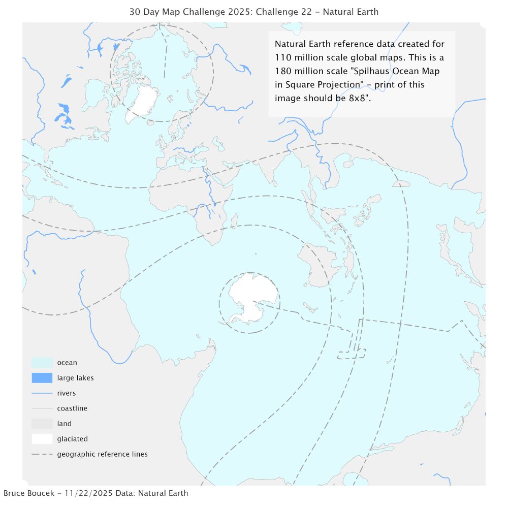
30 Day Map Challenge
Day 22: Natural Earth
#30daymapchallenge #30daymapchallenge2025
Natural Earth Data is created for world and regional maps at optimal scales. This map uses 110m scale Natural Earth data on an unusual projection - the Spilhaus Ocean Map in Square Projection.
Day 22: Natural Earth
#30daymapchallenge #30daymapchallenge2025
Natural Earth Data is created for world and regional maps at optimal scales. This map uses 110m scale Natural Earth data on an unusual projection - the Spilhaus Ocean Map in Square Projection.
November 23, 2025 at 2:24 AM
30 Day Map Challenge
Day 22: Natural Earth
#30daymapchallenge #30daymapchallenge2025
Natural Earth Data is created for world and regional maps at optimal scales. This map uses 110m scale Natural Earth data on an unusual projection - the Spilhaus Ocean Map in Square Projection.
Day 22: Natural Earth
#30daymapchallenge #30daymapchallenge2025
Natural Earth Data is created for world and regional maps at optimal scales. This map uses 110m scale Natural Earth data on an unusual projection - the Spilhaus Ocean Map in Square Projection.
30 Day Map Challenge
Day 21: Icons
#30daymapchallenge #30daymapchallenge2025
Not fully satisfied with this one. Playing around with a house icon, transparency, color, and size to tell a specific story. One particular outlier is problematic, and likely a typo. Reasons to explore spatial data.
Day 21: Icons
#30daymapchallenge #30daymapchallenge2025
Not fully satisfied with this one. Playing around with a house icon, transparency, color, and size to tell a specific story. One particular outlier is problematic, and likely a typo. Reasons to explore spatial data.

November 21, 2025 at 10:24 PM
30 Day Map Challenge
Day 21: Icons
#30daymapchallenge #30daymapchallenge2025
Not fully satisfied with this one. Playing around with a house icon, transparency, color, and size to tell a specific story. One particular outlier is problematic, and likely a typo. Reasons to explore spatial data.
Day 21: Icons
#30daymapchallenge #30daymapchallenge2025
Not fully satisfied with this one. Playing around with a house icon, transparency, color, and size to tell a specific story. One particular outlier is problematic, and likely a typo. Reasons to explore spatial data.
Got this advertisement - how to assess:

November 21, 2025 at 3:27 AM
Got this advertisement - how to assess:
Went to verify he posted what he posted:

November 21, 2025 at 3:26 AM
Went to verify he posted what he posted:
Got to see my friend Jane, who I’ve known for nearly 30 years, this evening. She gave a fantastic talk at Brown University’s GIS Week/DEEPS Colloquium. I convinced her to take a selfie with me, with the Harvard Center for Geographic Analysis sticker I brought for her.

November 21, 2025 at 2:53 AM
Got to see my friend Jane, who I’ve known for nearly 30 years, this evening. She gave a fantastic talk at Brown University’s GIS Week/DEEPS Colloquium. I convinced her to take a selfie with me, with the Harvard Center for Geographic Analysis sticker I brought for her.
30 Day Map Challenge
Day 20: Water
#30daymapchallenge #30daymapchallenge2025
A super fast, really, honestly, a lazy map. OTOH - a great demonstration of Water, rather than Earth.
Day 20: Water
#30daymapchallenge #30daymapchallenge2025
A super fast, really, honestly, a lazy map. OTOH - a great demonstration of Water, rather than Earth.

November 21, 2025 at 2:24 AM
30 Day Map Challenge
Day 20: Water
#30daymapchallenge #30daymapchallenge2025
A super fast, really, honestly, a lazy map. OTOH - a great demonstration of Water, rather than Earth.
Day 20: Water
#30daymapchallenge #30daymapchallenge2025
A super fast, really, honestly, a lazy map. OTOH - a great demonstration of Water, rather than Earth.
30 Day Map Challenge
Day 19: Projections
#30daymapchallenge #30daymapchallenge2025
Another 20 minute draft, but it conveys an important lesson about using local planar projections when working at local scales.
Day 19: Projections
#30daymapchallenge #30daymapchallenge2025
Another 20 minute draft, but it conveys an important lesson about using local planar projections when working at local scales.

November 19, 2025 at 4:00 PM
30 Day Map Challenge
Day 19: Projections
#30daymapchallenge #30daymapchallenge2025
Another 20 minute draft, but it conveys an important lesson about using local planar projections when working at local scales.
Day 19: Projections
#30daymapchallenge #30daymapchallenge2025
Another 20 minute draft, but it conveys an important lesson about using local planar projections when working at local scales.
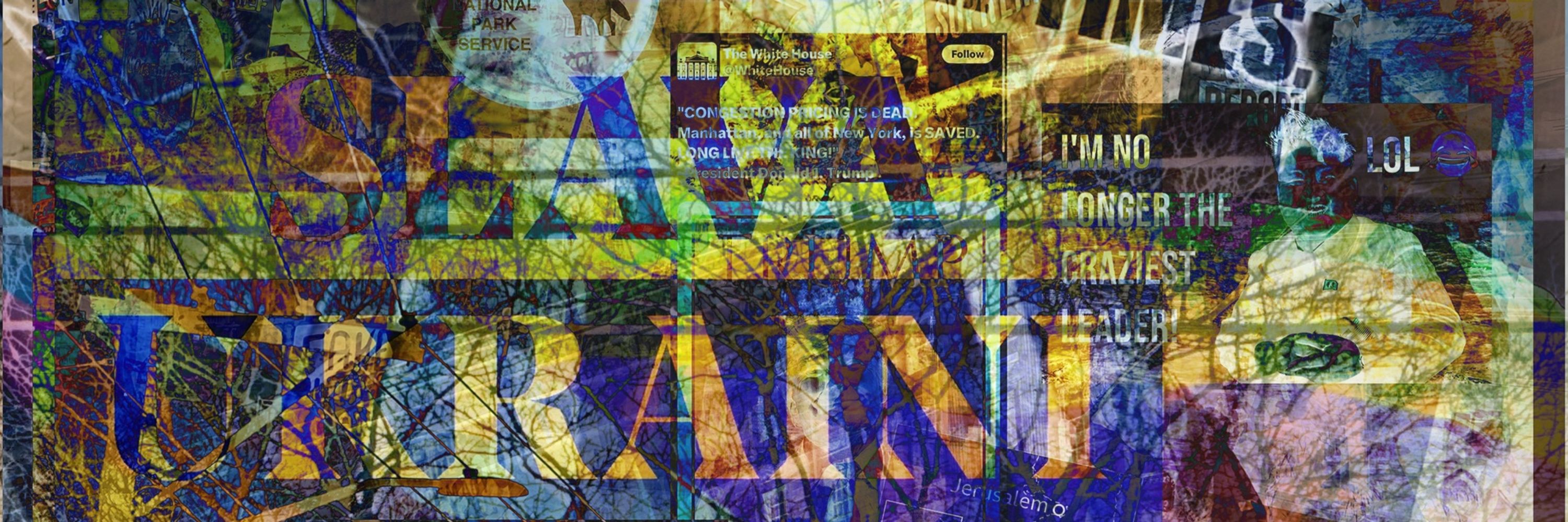
Today’s Kakistocracy amalgamation.

November 19, 2025 at 1:07 PM
Today’s Kakistocracy amalgamation.

30 Day Map Challenge
Day 18: Out of This World
#30daymapchallenge #30daymapchallenge2025
Found some imagery for Pluto:
astrogeology.usgs.gov/search/map/p...
Day 18: Out of This World
#30daymapchallenge #30daymapchallenge2025
Found some imagery for Pluto:
astrogeology.usgs.gov/search/map/p...

November 18, 2025 at 10:49 PM
30 Day Map Challenge
Day 18: Out of This World
#30daymapchallenge #30daymapchallenge2025
Found some imagery for Pluto:
astrogeology.usgs.gov/search/map/p...
Day 18: Out of This World
#30daymapchallenge #30daymapchallenge2025
Found some imagery for Pluto:
astrogeology.usgs.gov/search/map/p...
30 Day Map Challenge
Day 17: New Tool
#30daymapchallenge #30daymapchallenge2025
A busy day to explore something brand new. I’ve made maps or helped others make maps with so many different tools over the years.
I’m deeply skeptical of Gen AI. Used the embedded AI in iOS Freeform. Embarrassing US map
Day 17: New Tool
#30daymapchallenge #30daymapchallenge2025
A busy day to explore something brand new. I’ve made maps or helped others make maps with so many different tools over the years.
I’m deeply skeptical of Gen AI. Used the embedded AI in iOS Freeform. Embarrassing US map

November 18, 2025 at 3:07 AM
30 Day Map Challenge
Day 17: New Tool
#30daymapchallenge #30daymapchallenge2025
A busy day to explore something brand new. I’ve made maps or helped others make maps with so many different tools over the years.
I’m deeply skeptical of Gen AI. Used the embedded AI in iOS Freeform. Embarrassing US map
Day 17: New Tool
#30daymapchallenge #30daymapchallenge2025
A busy day to explore something brand new. I’ve made maps or helped others make maps with so many different tools over the years.
I’m deeply skeptical of Gen AI. Used the embedded AI in iOS Freeform. Embarrassing US map
Morning on the Blackstone/Seekonk River. Facing south.
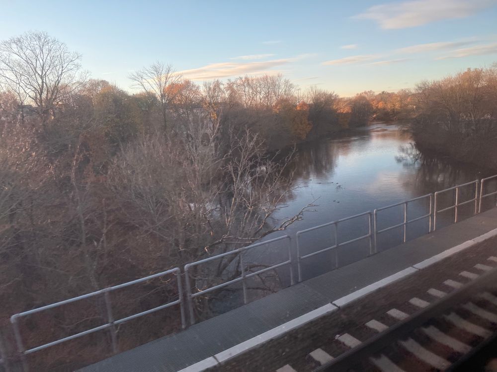

November 17, 2025 at 12:34 PM
Morning on the Blackstone/Seekonk River. Facing south.
30 Day Map Challenge
Day 16: Cell
#30daymapchallenge #30daymapchallenge2025
Revisiting a prior map - binning residential parcels into hexagonal cells to illustrate where people would be most likely to live in the Providence. Note: by "most likely" I am not using reproducible spatial analysis... ;-)
Day 16: Cell
#30daymapchallenge #30daymapchallenge2025
Revisiting a prior map - binning residential parcels into hexagonal cells to illustrate where people would be most likely to live in the Providence. Note: by "most likely" I am not using reproducible spatial analysis... ;-)

November 17, 2025 at 3:17 AM
30 Day Map Challenge
Day 16: Cell
#30daymapchallenge #30daymapchallenge2025
Revisiting a prior map - binning residential parcels into hexagonal cells to illustrate where people would be most likely to live in the Providence. Note: by "most likely" I am not using reproducible spatial analysis... ;-)
Day 16: Cell
#30daymapchallenge #30daymapchallenge2025
Revisiting a prior map - binning residential parcels into hexagonal cells to illustrate where people would be most likely to live in the Providence. Note: by "most likely" I am not using reproducible spatial analysis... ;-)
Sun setting. 4th is an amalgamation.


November 16, 2025 at 9:37 PM
Sun setting. 4th is an amalgamation.
30 Day Map Challenge
Day 15: Fire
#30daymapchallenge #30daymapchallenge2025
Looked for an interesting fire dataset.
Lots of agricultural land management with fire...
Information about the data here:
www.ospo.noaa.gov/products/lan...
One of many datasets your tax dollars pay to maintain.
Day 15: Fire
#30daymapchallenge #30daymapchallenge2025
Looked for an interesting fire dataset.
Lots of agricultural land management with fire...
Information about the data here:
www.ospo.noaa.gov/products/lan...
One of many datasets your tax dollars pay to maintain.

November 16, 2025 at 3:09 AM
30 Day Map Challenge
Day 15: Fire
#30daymapchallenge #30daymapchallenge2025
Looked for an interesting fire dataset.
Lots of agricultural land management with fire...
Information about the data here:
www.ospo.noaa.gov/products/lan...
One of many datasets your tax dollars pay to maintain.
Day 15: Fire
#30daymapchallenge #30daymapchallenge2025
Looked for an interesting fire dataset.
Lots of agricultural land management with fire...
Information about the data here:
www.ospo.noaa.gov/products/lan...
One of many datasets your tax dollars pay to maintain.

30 Day Map Challenge
Day 14: Open Street Map
#30daymapchallenge #30daymapchallenge2025
Really another 10 minute map.
Busy day & phone & laptop refusing to connect on the train. But, I thought it’s worth highlighting the default cartographic choices of OSM and I picked a place of interest to me.
Day 14: Open Street Map
#30daymapchallenge #30daymapchallenge2025
Really another 10 minute map.
Busy day & phone & laptop refusing to connect on the train. But, I thought it’s worth highlighting the default cartographic choices of OSM and I picked a place of interest to me.

November 14, 2025 at 11:20 PM
30 Day Map Challenge
Day 14: Open Street Map
#30daymapchallenge #30daymapchallenge2025
Really another 10 minute map.
Busy day & phone & laptop refusing to connect on the train. But, I thought it’s worth highlighting the default cartographic choices of OSM and I picked a place of interest to me.
Day 14: Open Street Map
#30daymapchallenge #30daymapchallenge2025
Really another 10 minute map.
Busy day & phone & laptop refusing to connect on the train. But, I thought it’s worth highlighting the default cartographic choices of OSM and I picked a place of interest to me.
Will we fade away… with nothing but a whimper…

November 14, 2025 at 1:11 PM
Will we fade away… with nothing but a whimper…