


Alan Godfrey Maps
@alangodfreymaps.bsky.social
Travel in time, witness the changes technology wrought upon Britain & beyond using our maps as a window into history, brought alive by our researchers & authors.
Great Gifts!
From £3.50 pp. https://www.alangodfreymaps.co.uk/acatalog/home.html
Great Gifts!
From £3.50 pp. https://www.alangodfreymaps.co.uk/acatalog/home.html
The Lunatic Asylum, Dover Street is typical of its time; part funded by local authority & part by donations from individuals & charities.
Our sample also shows parts of nearby institutions, which also saw largess over time by wealthy donors. How times change!
www.alangodfreymaps.co.uk/liv25.htm
Our sample also shows parts of nearby institutions, which also saw largess over time by wealthy donors. How times change!
www.alangodfreymaps.co.uk/liv25.htm

November 23, 2025 at 6:59 PM
The Lunatic Asylum, Dover Street is typical of its time; part funded by local authority & part by donations from individuals & charities.
Our sample also shows parts of nearby institutions, which also saw largess over time by wealthy donors. How times change!
www.alangodfreymaps.co.uk/liv25.htm
Our sample also shows parts of nearby institutions, which also saw largess over time by wealthy donors. How times change!
www.alangodfreymaps.co.uk/liv25.htm
But once the planning & speculation bears fruit (money), how does a Victorian industrialist spend it?
Perhaps funding a wealth of beautiful public buildings– libraries, reading rooms, museums, hospitals etc… so people think you’re not only wealthy & powerful, but also quite lovely, too, actually?
3/
Perhaps funding a wealth of beautiful public buildings– libraries, reading rooms, museums, hospitals etc… so people think you’re not only wealthy & powerful, but also quite lovely, too, actually?
3/
November 23, 2025 at 6:59 PM
But once the planning & speculation bears fruit (money), how does a Victorian industrialist spend it?
Perhaps funding a wealth of beautiful public buildings– libraries, reading rooms, museums, hospitals etc… so people think you’re not only wealthy & powerful, but also quite lovely, too, actually?
3/
Perhaps funding a wealth of beautiful public buildings– libraries, reading rooms, museums, hospitals etc… so people think you’re not only wealthy & powerful, but also quite lovely, too, actually?
3/
Liverpool (London Road) 1848-64.
The city planners that laid out parts of #Liverpool liked triangles, and many large ones can be seen on this map. It's foolish to suggest anything mystical, but many of the early city big-wigs were apparently Masons, & several city streets carry masonic names.
1/
The city planners that laid out parts of #Liverpool liked triangles, and many large ones can be seen on this map. It's foolish to suggest anything mystical, but many of the early city big-wigs were apparently Masons, & several city streets carry masonic names.
1/

November 23, 2025 at 6:59 PM
Liverpool (London Road) 1848-64.
The city planners that laid out parts of #Liverpool liked triangles, and many large ones can be seen on this map. It's foolish to suggest anything mystical, but many of the early city big-wigs were apparently Masons, & several city streets carry masonic names.
1/
The city planners that laid out parts of #Liverpool liked triangles, and many large ones can be seen on this map. It's foolish to suggest anything mystical, but many of the early city big-wigs were apparently Masons, & several city streets carry masonic names.
1/
Dr Gilbert T Bell echoes sentiments I have often mentioned on this account, in a far neater way than I could. Our Kelvinside 1893 map is accompanied by a wealth of period information and excellent writing.
www.alangodfreymaps.co.uk/lk0601.htm
/3
www.alangodfreymaps.co.uk/lk0601.htm
/3

November 23, 2025 at 12:28 PM
Dr Gilbert T Bell echoes sentiments I have often mentioned on this account, in a far neater way than I could. Our Kelvinside 1893 map is accompanied by a wealth of period information and excellent writing.
www.alangodfreymaps.co.uk/lk0601.htm
/3
www.alangodfreymaps.co.uk/lk0601.htm
/3
“A railway is under construction and gas works ooze power for home and factory. Brick works and timber yards, coal pits and reservoirs and even a laundry all show that the cities industries and people needed to be served.”
2/
2/
November 23, 2025 at 12:28 PM
“A railway is under construction and gas works ooze power for home and factory. Brick works and timber yards, coal pits and reservoirs and even a laundry all show that the cities industries and people needed to be served.”
2/
2/
Kelvinside 1893
“Maps show places in transition. Living places are changing places. Here one can almost sense the energy of a great city undergoing dramatic change. Fields await development. Roads are laid out in the full expectation that buildings will most assuredly soon line them.”
1/
“Maps show places in transition. Living places are changing places. Here one can almost sense the energy of a great city undergoing dramatic change. Fields await development. Roads are laid out in the full expectation that buildings will most assuredly soon line them.”
1/
November 23, 2025 at 12:28 PM
Kelvinside 1893
“Maps show places in transition. Living places are changing places. Here one can almost sense the energy of a great city undergoing dramatic change. Fields await development. Roads are laid out in the full expectation that buildings will most assuredly soon line them.”
1/
“Maps show places in transition. Living places are changing places. Here one can almost sense the energy of a great city undergoing dramatic change. Fields await development. Roads are laid out in the full expectation that buildings will most assuredly soon line them.”
1/
Hello!
Keep an eye on the account tomorrow, we're sharing TWO maps, continuing our look around a pair of the UK's greatest cities - #Glasgow and #Liverpool!
(We love you too, Edinburgh and Manchester x)
We'll also tell you a bit more about our brilliant 2-4-1 map offer!
Keep an eye on the account tomorrow, we're sharing TWO maps, continuing our look around a pair of the UK's greatest cities - #Glasgow and #Liverpool!
(We love you too, Edinburgh and Manchester x)
We'll also tell you a bit more about our brilliant 2-4-1 map offer!

November 22, 2025 at 7:31 PM
Hello!
Keep an eye on the account tomorrow, we're sharing TWO maps, continuing our look around a pair of the UK's greatest cities - #Glasgow and #Liverpool!
(We love you too, Edinburgh and Manchester x)
We'll also tell you a bit more about our brilliant 2-4-1 map offer!
Keep an eye on the account tomorrow, we're sharing TWO maps, continuing our look around a pair of the UK's greatest cities - #Glasgow and #Liverpool!
(We love you too, Edinburgh and Manchester x)
We'll also tell you a bit more about our brilliant 2-4-1 map offer!
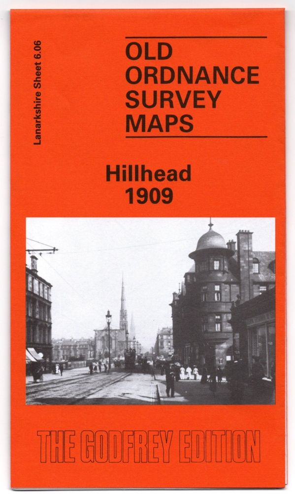
If you buy this map (and you really should!), trace the route of Buccleuch st. towards #Kelvingrove Park. At the end of the street The Tenement House museum can be found today & is well worth a visit for a snapshot of the era around the date of this map. The motorway you’ll see is newer though!
/4
/4

November 21, 2025 at 11:26 AM
If you buy this map (and you really should!), trace the route of Buccleuch st. towards #Kelvingrove Park. At the end of the street The Tenement House museum can be found today & is well worth a visit for a snapshot of the era around the date of this map. The motorway you’ll see is newer though!
/4
/4
At the top of our map you’d see #Glasgow Botanic Gardens, still there today in the same layout with stunning greenhouses hiding past intrigues & possibly murder!
As I (Andrew) consider my visits to the city, this map could still be used for transport/tourism. www.alangodfreymaps.co.uk/lk0606.htm
3/
As I (Andrew) consider my visits to the city, this map could still be used for transport/tourism. www.alangodfreymaps.co.uk/lk0606.htm
3/
November 21, 2025 at 11:26 AM
At the top of our map you’d see #Glasgow Botanic Gardens, still there today in the same layout with stunning greenhouses hiding past intrigues & possibly murder!
As I (Andrew) consider my visits to the city, this map could still be used for transport/tourism. www.alangodfreymaps.co.uk/lk0606.htm
3/
As I (Andrew) consider my visits to the city, this map could still be used for transport/tourism. www.alangodfreymaps.co.uk/lk0606.htm
3/
A short, lovely walk away you'll find the grandly imposing #Glasgow University complex, sitting with all the weight & posture of a gothic cathedral. The Hunterian Museum noted on the map is still open today, & a fascinating place to look around, as well as an excuse to see inside the University.
2/
2/
November 21, 2025 at 11:26 AM
A short, lovely walk away you'll find the grandly imposing #Glasgow University complex, sitting with all the weight & posture of a gothic cathedral. The Hunterian Museum noted on the map is still open today, & a fascinating place to look around, as well as an excuse to see inside the University.
2/
2/
Hillhead 1909 is a beautiful, swirling, mesmerising map.
Part of it marks the sites of the International Exhibitions of 1888 & 1901, the legacy of which are a great sweeping park & some stunning buildings, including the Kelvingrove Museum & Art Gallery, one of the finest Glaswegian institutions.
1/
Part of it marks the sites of the International Exhibitions of 1888 & 1901, the legacy of which are a great sweeping park & some stunning buildings, including the Kelvingrove Museum & Art Gallery, one of the finest Glaswegian institutions.
1/
November 21, 2025 at 11:26 AM
Hillhead 1909 is a beautiful, swirling, mesmerising map.
Part of it marks the sites of the International Exhibitions of 1888 & 1901, the legacy of which are a great sweeping park & some stunning buildings, including the Kelvingrove Museum & Art Gallery, one of the finest Glaswegian institutions.
1/
Part of it marks the sites of the International Exhibitions of 1888 & 1901, the legacy of which are a great sweeping park & some stunning buildings, including the Kelvingrove Museum & Art Gallery, one of the finest Glaswegian institutions.
1/
This map illustrates how important places on the seeming edge of the map can be. The port & habitations have been important since Viking times, not least to the locals who call the #Orkneys home.
Yet again, your author finds himself wanting to visit a place depicted beautifully in black & white!
/3
Yet again, your author finds himself wanting to visit a place depicted beautifully in black & white!
/3


November 20, 2025 at 10:40 AM
This map illustrates how important places on the seeming edge of the map can be. The port & habitations have been important since Viking times, not least to the locals who call the #Orkneys home.
Yet again, your author finds himself wanting to visit a place depicted beautifully in black & white!
/3
Yet again, your author finds himself wanting to visit a place depicted beautifully in black & white!
/3
Once more, a map I have no connect to was enhanced & hooked me with the extensive and excellent writing from our team of researchers. The language of the streets and geographic features are annotated perfectly, drawing the reader into the stories and lives of those in #Kirkwall & #Stromness 1902.
2/
2/
November 20, 2025 at 10:40 AM
Once more, a map I have no connect to was enhanced & hooked me with the extensive and excellent writing from our team of researchers. The language of the streets and geographic features are annotated perfectly, drawing the reader into the stories and lives of those in #Kirkwall & #Stromness 1902.
2/
2/
#Denmark held the #Orkneys until 1468, when it was essentially given to the Scottish crown as part of a dowry. As an apparent ‘southerner’, your Middlesbrough-born poster found continual surprise & interest in this map, brilliantly annotated by W.S. Hewison.
www.alangodfreymaps.co.uk/ork10803.htm
1/
www.alangodfreymaps.co.uk/ork10803.htm
1/
November 20, 2025 at 10:40 AM
#Denmark held the #Orkneys until 1468, when it was essentially given to the Scottish crown as part of a dowry. As an apparent ‘southerner’, your Middlesbrough-born poster found continual surprise & interest in this map, brilliantly annotated by W.S. Hewison.
www.alangodfreymaps.co.uk/ork10803.htm
1/
www.alangodfreymaps.co.uk/ork10803.htm
1/
The nearby Georgian Quarter – one of the biggest & most handsome in the country – is very well worth a walk around too, especially Rodney Street, which has been on TV countless times in period shows. There are also some excellent local pubs and restaurants nearby.
Please repost, like and comment!
Please repost, like and comment!

November 19, 2025 at 6:48 PM
The nearby Georgian Quarter – one of the biggest & most handsome in the country – is very well worth a walk around too, especially Rodney Street, which has been on TV countless times in period shows. There are also some excellent local pubs and restaurants nearby.
Please repost, like and comment!
Please repost, like and comment!
But I prefer the place literally overshadowed by the mighty church; a former quarry, repurposed as a cemetery when the great red walls rose. Dozens of feet below street level, you feel subsumed by the catacombs of the departed. The eeriest place in #Liverpool & a feeling well worth experiencing.
3/
3/

November 19, 2025 at 6:48 PM
But I prefer the place literally overshadowed by the mighty church; a former quarry, repurposed as a cemetery when the great red walls rose. Dozens of feet below street level, you feel subsumed by the catacombs of the departed. The eeriest place in #Liverpool & a feeling well worth experiencing.
3/
3/
The grandeur of the 20thC building couldn't be grander.
As a former local, I (Andrew) have a warm feeling when I see it - the view means home, as much as seeing the stately river from the dock, the imperial might of St Georges' or the railway cutting as I go into the rambunctious Lime St Station
2/
As a former local, I (Andrew) have a warm feeling when I see it - the view means home, as much as seeing the stately river from the dock, the imperial might of St Georges' or the railway cutting as I go into the rambunctious Lime St Station
2/
November 19, 2025 at 6:48 PM
The grandeur of the 20thC building couldn't be grander.
As a former local, I (Andrew) have a warm feeling when I see it - the view means home, as much as seeing the stately river from the dock, the imperial might of St Georges' or the railway cutting as I go into the rambunctious Lime St Station
2/
As a former local, I (Andrew) have a warm feeling when I see it - the view means home, as much as seeing the stately river from the dock, the imperial might of St Georges' or the railway cutting as I go into the rambunctious Lime St Station
2/
Part of our map is almost unrecognisable today; it's the site of one of the great city landmarks.
The biggest religious building in Britain & the world’s 8th biggest church, #Liverpool Cathedral appears to hover above the city.
Liverpool (St James’ Mount) 1849- www.alangodfreymaps.co.uk/liv35.htm
1/
The biggest religious building in Britain & the world’s 8th biggest church, #Liverpool Cathedral appears to hover above the city.
Liverpool (St James’ Mount) 1849- www.alangodfreymaps.co.uk/liv35.htm
1/

November 19, 2025 at 6:48 PM
Part of our map is almost unrecognisable today; it's the site of one of the great city landmarks.
The biggest religious building in Britain & the world’s 8th biggest church, #Liverpool Cathedral appears to hover above the city.
Liverpool (St James’ Mount) 1849- www.alangodfreymaps.co.uk/liv35.htm
1/
The biggest religious building in Britain & the world’s 8th biggest church, #Liverpool Cathedral appears to hover above the city.
Liverpool (St James’ Mount) 1849- www.alangodfreymaps.co.uk/liv35.htm
1/
1900 was a year in #Aberdeen filled with real industriousness and vibrancy, and a history deeply intriguing. 125 years on, we can say the very same thing about the city, a place connected to millions around the world.
£3.50 plus postage, www.alangodfreymaps.co.uk/ab7511.htm
/4
£3.50 plus postage, www.alangodfreymaps.co.uk/ab7511.htm
/4

November 19, 2025 at 7:59 AM
1900 was a year in #Aberdeen filled with real industriousness and vibrancy, and a history deeply intriguing. 125 years on, we can say the very same thing about the city, a place connected to millions around the world.
£3.50 plus postage, www.alangodfreymaps.co.uk/ab7511.htm
/4
£3.50 plus postage, www.alangodfreymaps.co.uk/ab7511.htm
/4
…overseas competition, fashions changed, industries fell into depression, war & losses rolled across the world.
Granite is a hard stone however, as hard as the local spirit. In the 1970s, oil was discovered in the north sea & #Aberdeen became the beating black soul of the European old industry.
3/
Granite is a hard stone however, as hard as the local spirit. In the 1970s, oil was discovered in the north sea & #Aberdeen became the beating black soul of the European old industry.
3/

November 19, 2025 at 7:59 AM
…overseas competition, fashions changed, industries fell into depression, war & losses rolled across the world.
Granite is a hard stone however, as hard as the local spirit. In the 1970s, oil was discovered in the north sea & #Aberdeen became the beating black soul of the European old industry.
3/
Granite is a hard stone however, as hard as the local spirit. In the 1970s, oil was discovered in the north sea & #Aberdeen became the beating black soul of the European old industry.
3/
The #Aberdeen 1900 map marks the high-point of the industry that even today is synonymous with the city. We even mentioned it in our introduction. Ninety quarries employing 2,500 men supporting many more in the wider city area, but as time rolled on familiar issues arose…
2/
2/
November 19, 2025 at 7:59 AM
The #Aberdeen 1900 map marks the high-point of the industry that even today is synonymous with the city. We even mentioned it in our introduction. Ninety quarries employing 2,500 men supporting many more in the wider city area, but as time rolled on familiar issues arose…
2/
2/
With a granite heart & saltwater in the blood, #Aberdeen is a classic Scottish city.
With the boldness of a man hacking granite from the quarries around the city, Victorian Aberdonians reshaped the landscape, moving the course of the very river and reshaping the coastline to create a great port.
1/
With the boldness of a man hacking granite from the quarries around the city, Victorian Aberdonians reshaped the landscape, moving the course of the very river and reshaping the coastline to create a great port.
1/
November 19, 2025 at 7:59 AM
With a granite heart & saltwater in the blood, #Aberdeen is a classic Scottish city.
With the boldness of a man hacking granite from the quarries around the city, Victorian Aberdonians reshaped the landscape, moving the course of the very river and reshaping the coastline to create a great port.
1/
With the boldness of a man hacking granite from the quarries around the city, Victorian Aberdonians reshaped the landscape, moving the course of the very river and reshaping the coastline to create a great port.
1/
Festive Bargains!
2 – 4 – 1 Sale!
25 UK places, decades apart, £3.50 +post!
Subscriptions!
LIVE - #Exeter (starting Jan) & #Cambridge (starting Dec) - £33!
SOON - A new batch of #London Large Scale maps!
Check out our web-shop - www.alangodfreymaps.co.uk/acatalog/hom...
Please *Like* & *Retweet*
2 – 4 – 1 Sale!
25 UK places, decades apart, £3.50 +post!
Subscriptions!
LIVE - #Exeter (starting Jan) & #Cambridge (starting Dec) - £33!
SOON - A new batch of #London Large Scale maps!
Check out our web-shop - www.alangodfreymaps.co.uk/acatalog/hom...
Please *Like* & *Retweet*

November 18, 2025 at 11:44 AM
Festive Bargains!
2 – 4 – 1 Sale!
25 UK places, decades apart, £3.50 +post!
Subscriptions!
LIVE - #Exeter (starting Jan) & #Cambridge (starting Dec) - £33!
SOON - A new batch of #London Large Scale maps!
Check out our web-shop - www.alangodfreymaps.co.uk/acatalog/hom...
Please *Like* & *Retweet*
2 – 4 – 1 Sale!
25 UK places, decades apart, £3.50 +post!
Subscriptions!
LIVE - #Exeter (starting Jan) & #Cambridge (starting Dec) - £33!
SOON - A new batch of #London Large Scale maps!
Check out our web-shop - www.alangodfreymaps.co.uk/acatalog/hom...
Please *Like* & *Retweet*
Eventually the town found some stability & Alan notes a friendly place worth more than the brief glimpse most visitors give Holyhead as they flit from car/train to ferry or vice-versa. Indeed, the town has pre-roman heritage, & its history is worth looking into. www.alangodfreymaps.co.uk/ang1102.htm

November 17, 2025 at 8:54 AM
Eventually the town found some stability & Alan notes a friendly place worth more than the brief glimpse most visitors give Holyhead as they flit from car/train to ferry or vice-versa. Indeed, the town has pre-roman heritage, & its history is worth looking into. www.alangodfreymaps.co.uk/ang1102.htm
With the turbulences of the early 20th century in Ireland, the need for travel between the islands fell. The rise of other ports with better onward travel links were a further blow. Housing stock, already poor, worsened and the population fell.
(Printed map is clearer than the samples shown.)
3/
(Printed map is clearer than the samples shown.)
3/

November 17, 2025 at 8:54 AM
With the turbulences of the early 20th century in Ireland, the need for travel between the islands fell. The rise of other ports with better onward travel links were a further blow. Housing stock, already poor, worsened and the population fell.
(Printed map is clearer than the samples shown.)
3/
(Printed map is clearer than the samples shown.)
3/