


@adamplatform.bsky.social
Sunshine and above-average temperatures over #Italy but worsening #airquality.
According to @copernicusecmwf.bsky.social (CAMS), high PM₂․₅ levels are expected this afternoon across the #PoValley, with peaks above 75 µg/m³ — about four times higher than the WHO daily limit (15 µg/m³).
According to @copernicusecmwf.bsky.social (CAMS), high PM₂․₅ levels are expected this afternoon across the #PoValley, with peaks above 75 µg/m³ — about four times higher than the WHO daily limit (15 µg/m³).

November 12, 2025 at 1:36 PM
Sunshine and above-average temperatures over #Italy but worsening #airquality.
According to @copernicusecmwf.bsky.social (CAMS), high PM₂․₅ levels are expected this afternoon across the #PoValley, with peaks above 75 µg/m³ — about four times higher than the WHO daily limit (15 µg/m³).
According to @copernicusecmwf.bsky.social (CAMS), high PM₂․₅ levels are expected this afternoon across the #PoValley, with peaks above 75 µg/m³ — about four times higher than the WHO daily limit (15 µg/m³).
Emergency #drought in #Iran: water levels in the Amir Kabir Dam — supplying drinking water to #Tehran — is below 8%. The country is suffering after months of drought and record heat. The video shows the #Copernicus #Sentinel2 image on Nov. 2 2024 and Nov. 9 2025. #climateemergency
November 10, 2025 at 5:20 PM
Emergency #drought in #Iran: water levels in the Amir Kabir Dam — supplying drinking water to #Tehran — is below 8%. The country is suffering after months of drought and record heat. The video shows the #Copernicus #Sentinel2 image on Nov. 2 2024 and Nov. 9 2025. #climateemergency
Massive dust plume crosses the Persian Gulf! Captured on Nov. 4 by #Copernicus #Sentinel3, this amazing image shows the enormous dust cloud from southern #Iran and #Pakistan making its way to #Oman and #UAE. #AirQuality

November 7, 2025 at 4:41 PM
Massive dust plume crosses the Persian Gulf! Captured on Nov. 4 by #Copernicus #Sentinel3, this amazing image shows the enormous dust cloud from southern #Iran and #Pakistan making its way to #Oman and #UAE. #AirQuality
The aftermath of Hurricane #Melissa in central/eastern #Jamaica observed from space.
The #Copernicus #Sentinel2 captured on October 31st this remarkable image highlighting the discharge of fluvial sediments into the marine environment. #ClimateEmergency
The #Copernicus #Sentinel2 captured on October 31st this remarkable image highlighting the discharge of fluvial sediments into the marine environment. #ClimateEmergency

November 1, 2025 at 4:51 PM
The aftermath of Hurricane #Melissa in central/eastern #Jamaica observed from space.
The #Copernicus #Sentinel2 captured on October 31st this remarkable image highlighting the discharge of fluvial sediments into the marine environment. #ClimateEmergency
The #Copernicus #Sentinel2 captured on October 31st this remarkable image highlighting the discharge of fluvial sediments into the marine environment. #ClimateEmergency
#Hurricane #Melissa has intensified to a Category 5 system while moving northwest through the #Caribbean Sea toward Jamaica, per the latest NHC Atlantic update. The #Copernicus #Sentinel3 image collected on Oct. 26 shows the eye of storm heading to #Jamaica.
#HurricaneMelissa
#HurricaneMelissa

October 27, 2025 at 10:56 AM
#Hurricane #Melissa has intensified to a Category 5 system while moving northwest through the #Caribbean Sea toward Jamaica, per the latest NHC Atlantic update. The #Copernicus #Sentinel3 image collected on Oct. 26 shows the eye of storm heading to #Jamaica.
#HurricaneMelissa
#HurricaneMelissa
The incredible 'brightness' of #Diwali celebrations also extends to the sky.
The #Copernicus #Sentinel5p NO2 map in the video shows the increased presence of thick smog over #NewDehli, during and after the #Hindu festival, as fireworks fill the air with pollutants. #AirQuality
The #Copernicus #Sentinel5p NO2 map in the video shows the increased presence of thick smog over #NewDehli, during and after the #Hindu festival, as fireworks fill the air with pollutants. #AirQuality
October 23, 2025 at 10:52 AM
The incredible 'brightness' of #Diwali celebrations also extends to the sky.
The #Copernicus #Sentinel5p NO2 map in the video shows the increased presence of thick smog over #NewDehli, during and after the #Hindu festival, as fireworks fill the air with pollutants. #AirQuality
The #Copernicus #Sentinel5p NO2 map in the video shows the increased presence of thick smog over #NewDehli, during and after the #Hindu festival, as fireworks fill the air with pollutants. #AirQuality
Northern #Vietnam has been hit by extreme weather, facing its worst #floods in 60 years and devastating landslides.
📹 The video shows #Nguyencity and the Song Gau River before and after Storm #Matmo, captured by #Copernicus #Sentinel2 on July 31 and October 9. #climateemergency
📹 The video shows #Nguyencity and the Song Gau River before and after Storm #Matmo, captured by #Copernicus #Sentinel2 on July 31 and October 9. #climateemergency
October 11, 2025 at 7:18 AM
Northern #Vietnam has been hit by extreme weather, facing its worst #floods in 60 years and devastating landslides.
📹 The video shows #Nguyencity and the Song Gau River before and after Storm #Matmo, captured by #Copernicus #Sentinel2 on July 31 and October 9. #climateemergency
📹 The video shows #Nguyencity and the Song Gau River before and after Storm #Matmo, captured by #Copernicus #Sentinel2 on July 31 and October 9. #climateemergency
Stunning image of Hurricanes #Humberto and #Imelda ‘dancing’ over #Atlantic threating #Bermuda.
The #Copernicus #Sentinel3 image was captured on September 30.
#Hurricane #climateemergency
The #Copernicus #Sentinel3 image was captured on September 30.
#Hurricane #climateemergency

October 1, 2025 at 3:59 PM
Stunning image of Hurricanes #Humberto and #Imelda ‘dancing’ over #Atlantic threating #Bermuda.
The #Copernicus #Sentinel3 image was captured on September 30.
#Hurricane #climateemergency
The #Copernicus #Sentinel3 image was captured on September 30.
#Hurricane #climateemergency
Wildfires in #Canada are still burning in September, fueled by extreme heat and lightning strikes.
In British Columbia, around 150 fires remain active, marking one of the worst #wildfire seasons on record. #ClimateEmergency #BCwildfire
In British Columbia, around 150 fires remain active, marking one of the worst #wildfire seasons on record. #ClimateEmergency #BCwildfire

September 10, 2025 at 3:50 PM
Wildfires in #Canada are still burning in September, fueled by extreme heat and lightning strikes.
In British Columbia, around 150 fires remain active, marking one of the worst #wildfire seasons on record. #ClimateEmergency #BCwildfire
In British Columbia, around 150 fires remain active, marking one of the worst #wildfire seasons on record. #ClimateEmergency #BCwildfire
From #Canada to #Europe! The huge plume from the Canadian #wildfires has reached #France, the #UK and Northern European Countries, as shown in the #Copernicus #Sentinel5p CO map on Aug. the 5th. #AirQuality

August 6, 2025 at 10:45 AM
From #Canada to #Europe! The huge plume from the Canadian #wildfires has reached #France, the #UK and Northern European Countries, as shown in the #Copernicus #Sentinel5p CO map on Aug. the 5th. #AirQuality
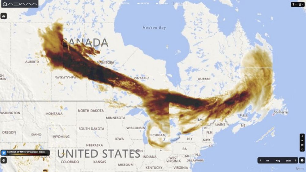
Hazy skies over #Canada. The Country is experiencing the second worst season of #wildfires, with almost 800 fires active.
A smoke plume of more than 3000km has been captured by #Copernicus #Sentinel5p Aerosol Index on August 3rd, affecting Canada and several US States #Airquality
A smoke plume of more than 3000km has been captured by #Copernicus #Sentinel5p Aerosol Index on August 3rd, affecting Canada and several US States #Airquality
August 4, 2025 at 7:32 PM
Hazy skies over #Canada. The Country is experiencing the second worst season of #wildfires, with almost 800 fires active.
A smoke plume of more than 3000km has been captured by #Copernicus #Sentinel5p Aerosol Index on August 3rd, affecting Canada and several US States #Airquality
A smoke plume of more than 3000km has been captured by #Copernicus #Sentinel5p Aerosol Index on August 3rd, affecting Canada and several US States #Airquality
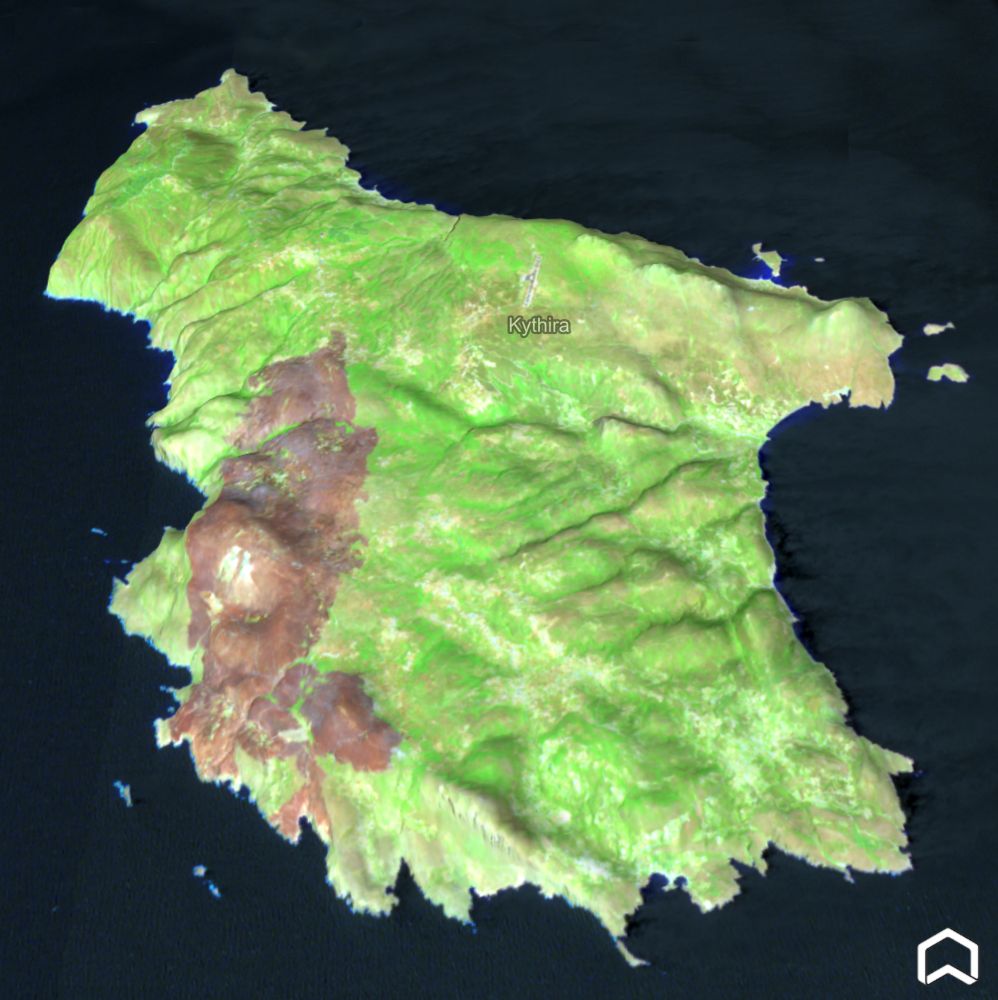
Impressive view of #Kythira island, #Greece, after the devastating wildfires occurred on Saturday.
The #Copernicus #Sentinel2 image, collected on July 28, shows the burned area, almost 20% of the whole island, caused by the largest fire during this #heatwave. #ClimateEmergency
The #Copernicus #Sentinel2 image, collected on July 28, shows the burned area, almost 20% of the whole island, caused by the largest fire during this #heatwave. #ClimateEmergency
July 30, 2025 at 2:20 PM
Impressive view of #Kythira island, #Greece, after the devastating wildfires occurred on Saturday.
The #Copernicus #Sentinel2 image, collected on July 28, shows the burned area, almost 20% of the whole island, caused by the largest fire during this #heatwave. #ClimateEmergency
The #Copernicus #Sentinel2 image, collected on July 28, shows the burned area, almost 20% of the whole island, caused by the largest fire during this #heatwave. #ClimateEmergency
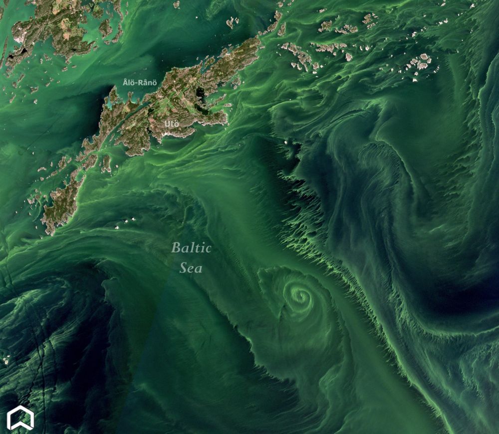
Huge algal bloom on the #Baltic Sea!
The #Copernicus #Sentinel2 image, colliected on July 21st shows an enormous swirling algal bloom on the eastern part of swedisch islands, during the longest #heatwave ever for #Scandinavia.
The #Copernicus #Sentinel2 image, colliected on July 21st shows an enormous swirling algal bloom on the eastern part of swedisch islands, during the longest #heatwave ever for #Scandinavia.
July 23, 2025 at 7:54 AM
Huge algal bloom on the #Baltic Sea!
The #Copernicus #Sentinel2 image, colliected on July 21st shows an enormous swirling algal bloom on the eastern part of swedisch islands, during the longest #heatwave ever for #Scandinavia.
The #Copernicus #Sentinel2 image, colliected on July 21st shows an enormous swirling algal bloom on the eastern part of swedisch islands, during the longest #heatwave ever for #Scandinavia.
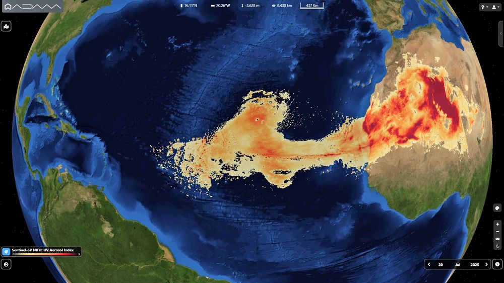
Huge #Saharandust transport across two continents.
The big cloud is moving toward #Carribean and #Brazil as shown by #Copernicus #Sentinel5p aerosol map on July 20th. #Airquality
The big cloud is moving toward #Carribean and #Brazil as shown by #Copernicus #Sentinel5p aerosol map on July 20th. #Airquality
July 22, 2025 at 7:42 AM
Huge #Saharandust transport across two continents.
The big cloud is moving toward #Carribean and #Brazil as shown by #Copernicus #Sentinel5p aerosol map on July 20th. #Airquality
The big cloud is moving toward #Carribean and #Brazil as shown by #Copernicus #Sentinel5p aerosol map on July 20th. #Airquality
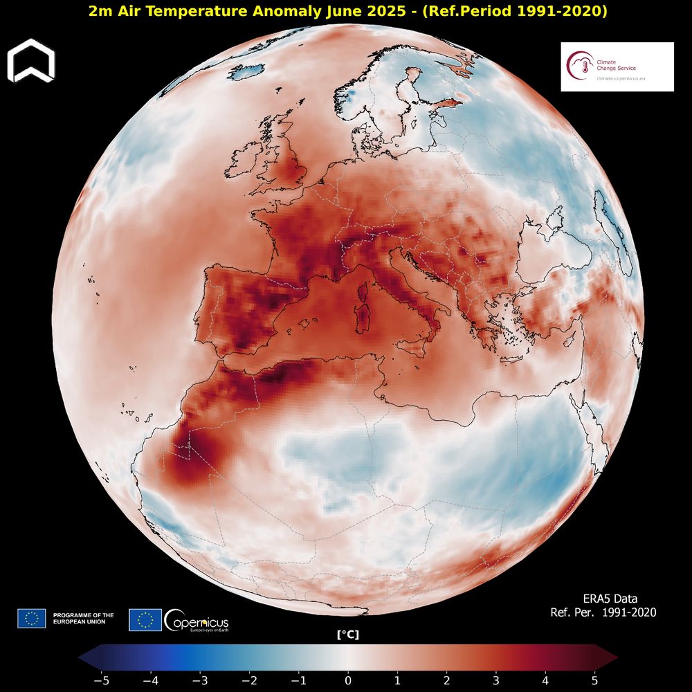
One of the warmest June for #Europe, the warmest on record for West Europe. According to the @CopernicusECMWF ERA5 Data globally the last month was 0.47°C warmer than the 1991-2020 average for June.
#ClimateEmergency
#ClimateEmergency
July 11, 2025 at 1:41 PM
One of the warmest June for #Europe, the warmest on record for West Europe. According to the @CopernicusECMWF ERA5 Data globally the last month was 0.47°C warmer than the 1991-2020 average for June.
#ClimateEmergency
#ClimateEmergency
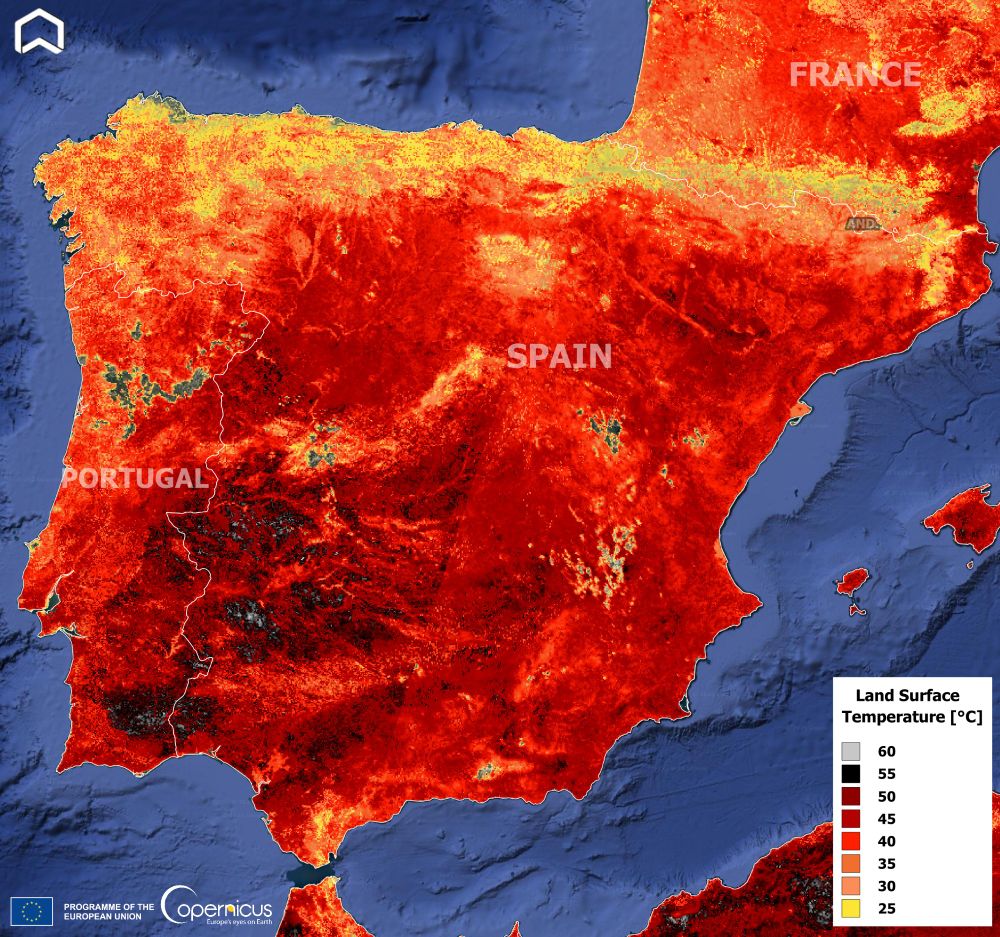
The intense #heatwave in #IberianPeninsula in July 29 from space.
The #Copernicus #Sentinel3 image offers an impressive Land Surface Temperature (not air) map!
#Ondadecalor #oladecalor #Spain #Portugal #France #climateemergency
The #Copernicus #Sentinel3 image offers an impressive Land Surface Temperature (not air) map!
#Ondadecalor #oladecalor #Spain #Portugal #France #climateemergency
July 1, 2025 at 8:53 AM
The intense #heatwave in #IberianPeninsula in July 29 from space.
The #Copernicus #Sentinel3 image offers an impressive Land Surface Temperature (not air) map!
#Ondadecalor #oladecalor #Spain #Portugal #France #climateemergency
The #Copernicus #Sentinel3 image offers an impressive Land Surface Temperature (not air) map!
#Ondadecalor #oladecalor #Spain #Portugal #France #climateemergency
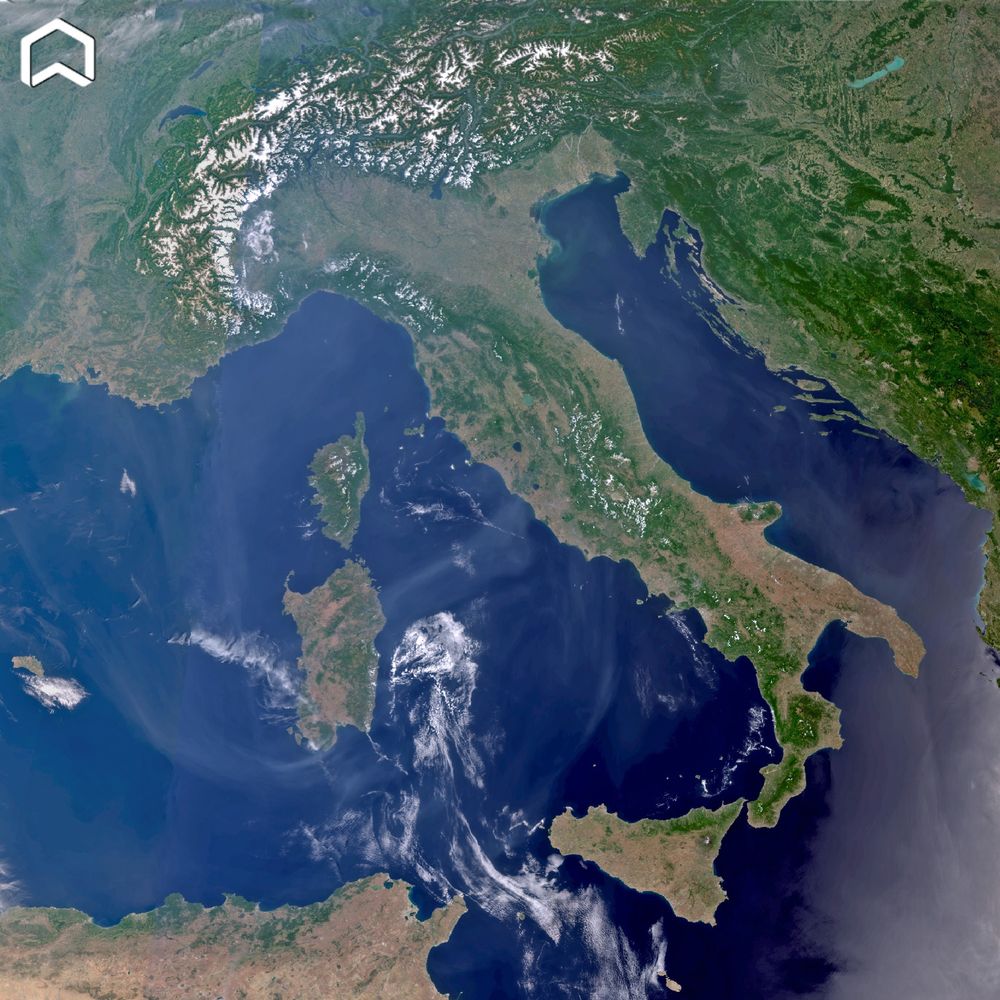
Smoke from the #Canadafires reached #Europe. The #Copernicus #Sentinel3 image collected on June 10 shows the huge plume, after a journey of 7000 km, over #Italy.
Il fumo degli incendi in #Canada ha raggiunto l'Europa e l' #Italia come evidenzia l'immagine satellitare. #airquality
Il fumo degli incendi in #Canada ha raggiunto l'Europa e l' #Italia come evidenzia l'immagine satellitare. #airquality
June 11, 2025 at 5:34 PM
Smoke from the #Canadafires reached #Europe. The #Copernicus #Sentinel3 image collected on June 10 shows the huge plume, after a journey of 7000 km, over #Italy.
Il fumo degli incendi in #Canada ha raggiunto l'Europa e l' #Italia come evidenzia l'immagine satellitare. #airquality
Il fumo degli incendi in #Canada ha raggiunto l'Europa e l' #Italia come evidenzia l'immagine satellitare. #airquality
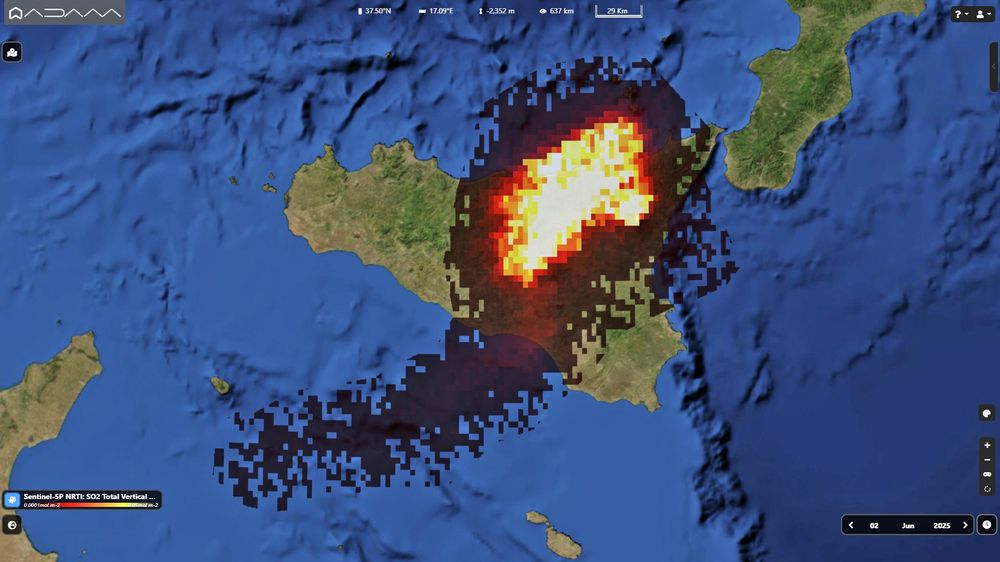
The first paroxysm of #Etna in the last 18 months from #space.
The #Copernicus #Sentinel5p map on June 2nd shows the SO2 plume related to the eruption at Southeast Crater.
L'eruzione dell'Etna del 2 giugno vista da satellite. #Airquality #EtnaEruption #tropomi
The #Copernicus #Sentinel5p map on June 2nd shows the SO2 plume related to the eruption at Southeast Crater.
L'eruzione dell'Etna del 2 giugno vista da satellite. #Airquality #EtnaEruption #tropomi
June 3, 2025 at 4:09 PM
The first paroxysm of #Etna in the last 18 months from #space.
The #Copernicus #Sentinel5p map on June 2nd shows the SO2 plume related to the eruption at Southeast Crater.
L'eruzione dell'Etna del 2 giugno vista da satellite. #Airquality #EtnaEruption #tropomi
The #Copernicus #Sentinel5p map on June 2nd shows the SO2 plume related to the eruption at Southeast Crater.
L'eruzione dell'Etna del 2 giugno vista da satellite. #Airquality #EtnaEruption #tropomi
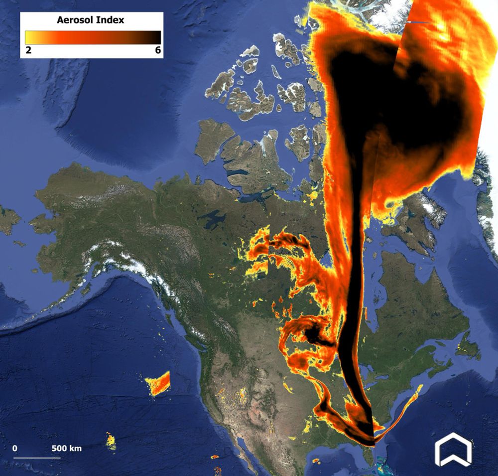
From #Arctic ti #Florida! The #Copernicus #Sentinel5p Aerosol map of May 31st shows the huge plume of smoke from the #canadafires. #Airquality #Canada #ClimateEmergency
June 1, 2025 at 2:07 PM
From #Arctic ti #Florida! The #Copernicus #Sentinel5p Aerosol map of May 31st shows the huge plume of smoke from the #canadafires. #Airquality #Canada #ClimateEmergency
Impressive before-and-after the collapse of #BirchGlacier in #Switzerland. The video shows the #Nasa #Landsat images on June 19 2024 and May 29 2025. The Village of #Blatten got almost completely buried.
May 30, 2025 at 1:38 PM
Impressive before-and-after the collapse of #BirchGlacier in #Switzerland. The video shows the #Nasa #Landsat images on June 19 2024 and May 29 2025. The Village of #Blatten got almost completely buried.
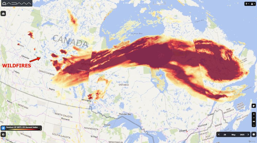
Impressive view of #Canada #wildfires's plume. There are 134 active fires, half of them considered out of control. The #Copernicus #Sentinel5p Aerosol Index map on May 27 shows the huge cloud of smoke (more than 3000 km long) reaching #USA. #Manitoba #Saskatchewan #Airquality #climateemergency
May 29, 2025 at 1:05 PM
Impressive view of #Canada #wildfires's plume. There are 134 active fires, half of them considered out of control. The #Copernicus #Sentinel5p Aerosol Index map on May 27 shows the huge cloud of smoke (more than 3000 km long) reaching #USA. #Manitoba #Saskatchewan #Airquality #climateemergency
#Drought warning in #England.
In UK it's the driest spring in 69 years.
The video shows the comparison of two #Copernicus #Sentinel2 images of the #Woodhead reservoir in #Derbyshire on May 18 2024 (water level was at 83%) and May 12 2025 (level at 56%). #ClimateEmergency
In UK it's the driest spring in 69 years.
The video shows the comparison of two #Copernicus #Sentinel2 images of the #Woodhead reservoir in #Derbyshire on May 18 2024 (water level was at 83%) and May 12 2025 (level at 56%). #ClimateEmergency
May 21, 2025 at 4:43 PM
#Drought warning in #England.
In UK it's the driest spring in 69 years.
The video shows the comparison of two #Copernicus #Sentinel2 images of the #Woodhead reservoir in #Derbyshire on May 18 2024 (water level was at 83%) and May 12 2025 (level at 56%). #ClimateEmergency
In UK it's the driest spring in 69 years.
The video shows the comparison of two #Copernicus #Sentinel2 images of the #Woodhead reservoir in #Derbyshire on May 18 2024 (water level was at 83%) and May 12 2025 (level at 56%). #ClimateEmergency
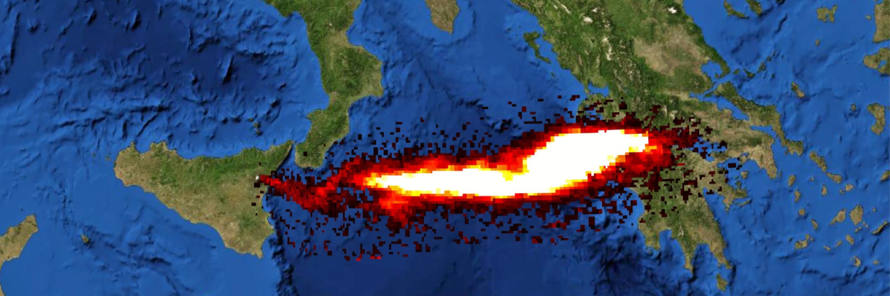
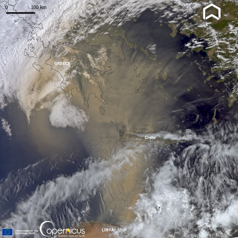
Awesome huge #Saharandust transport over #Greece.
The #Copernicus #Sentinel3 image collected on May 16th shows the plume moving from #Lybia to Mediterranean coasts. #Airquality
The #Copernicus #Sentinel3 image collected on May 16th shows the plume moving from #Lybia to Mediterranean coasts. #Airquality
May 17, 2025 at 11:55 AM
Awesome huge #Saharandust transport over #Greece.
The #Copernicus #Sentinel3 image collected on May 16th shows the plume moving from #Lybia to Mediterranean coasts. #Airquality
The #Copernicus #Sentinel3 image collected on May 16th shows the plume moving from #Lybia to Mediterranean coasts. #Airquality
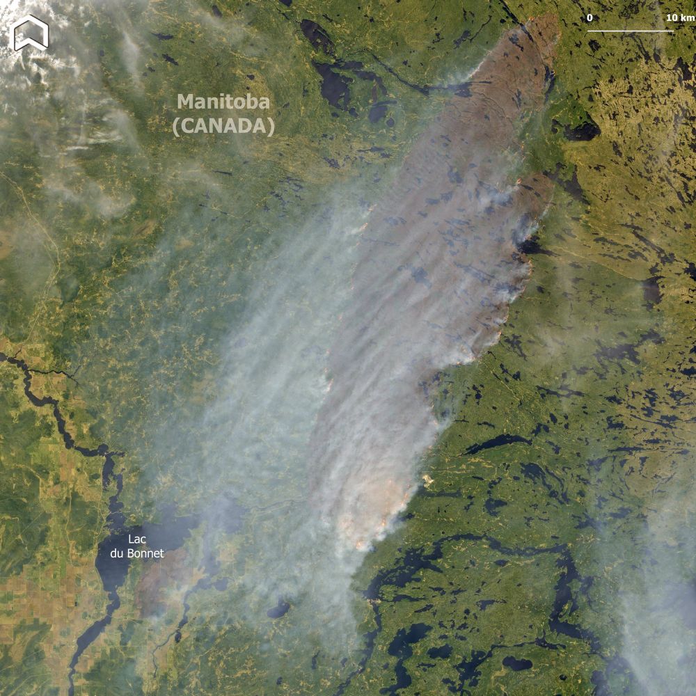
The first impressive image of the #LacduBonnet #wildfires in #Manitoba - that burned almost 4000 ha - was captured on May 14th by #Copernicus #Sentinel2.
Due to #drought conditions, this wildfire season in #Canada could be more intense than usual. #climateemergency
Due to #drought conditions, this wildfire season in #Canada could be more intense than usual. #climateemergency
May 15, 2025 at 6:26 PM
The first impressive image of the #LacduBonnet #wildfires in #Manitoba - that burned almost 4000 ha - was captured on May 14th by #Copernicus #Sentinel2.
Due to #drought conditions, this wildfire season in #Canada could be more intense than usual. #climateemergency
Due to #drought conditions, this wildfire season in #Canada could be more intense than usual. #climateemergency
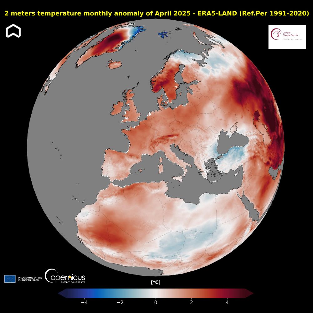
The last month was the second warmest #April globally. The average temperature over #Europe was 1.01°C above the ref. period. The largest anomalies are over east. Europe, west. #Russia, #Norway according to
@copernicusecmwf.bsky.social ERA5-Land computed by
@sistemagmbh.bsky.social. #ClimateHub
@copernicusecmwf.bsky.social ERA5-Land computed by
@sistemagmbh.bsky.social. #ClimateHub
May 9, 2025 at 2:43 PM
The last month was the second warmest #April globally. The average temperature over #Europe was 1.01°C above the ref. period. The largest anomalies are over east. Europe, west. #Russia, #Norway according to
@copernicusecmwf.bsky.social ERA5-Land computed by
@sistemagmbh.bsky.social. #ClimateHub
@copernicusecmwf.bsky.social ERA5-Land computed by
@sistemagmbh.bsky.social. #ClimateHub