


Andrew Ba Tran
@abtran.bsky.social
Washington Post Investigative Data Reporter
The mysterious rise of cancer among young adults in the Corn Belt. This story has both bivariate maps AND a color-coded scatterplot with explainers! #dataviz


October 28, 2025 at 3:45 PM
The mysterious rise of cancer among young adults in the Corn Belt. This story has both bivariate maps AND a color-coded scatterplot with explainers! #dataviz
We analyzed open source ADS-B data which leaves out countless other military aircraft that fly over D.C with their transponders off for reasons of "national security." Still, with the data we had available we could drill down into which neighborhoods are seeing the most change.


September 20, 2025 at 10:07 PM
We analyzed open source ADS-B data which leaves out countless other military aircraft that fly over D.C with their transponders off for reasons of "national security." Still, with the data we had available we could drill down into which neighborhoods are seeing the most change.
Washington’s Metropolitan Police Department’s officer count alone already puts D.C. ahead of any other large city in the United States per capita. Including the additional federal officials means there’s currently one officer for every 100 residents in D.C. www.washingtonpost.com/dc-md-va/202...

August 15, 2025 at 4:48 PM
Washington’s Metropolitan Police Department’s officer count alone already puts D.C. ahead of any other large city in the United States per capita. Including the additional federal officials means there’s currently one officer for every 100 residents in D.C. www.washingtonpost.com/dc-md-va/202...
Adding another example to my college class folder of "wtf dataviz"
July 30, 2025 at 4:48 PM
Adding another example to my college class folder of "wtf dataviz"
The National Archives had a message yesterday that their College Park facility would become restricted-access. This would be a horrible. We visited often last year to research Indian Boarding schools and the cartographic staff were so helpful. I saw hundreds of citizens getting help looking up docs.


June 25, 2025 at 1:41 PM
The National Archives had a message yesterday that their College Park facility would become restricted-access. This would be a horrible. We visited often last year to research Indian Boarding schools and the cartographic staff were so helpful. I saw hundreds of citizens getting help looking up docs.
Why's Marion such a popular a town name in the Midwest? And Fairview in the South?

April 21, 2025 at 8:27 PM
Why's Marion such a popular a town name in the Midwest? And Fairview in the South?
Tied between Fairview and Franklin!

April 21, 2025 at 8:19 PM
Tied between Fairview and Franklin!
Most common by region:

April 21, 2025 at 8:09 PM
Most common by region:

March 8, 2025 at 8:47 PM
Left a bunch of tidycensus tip sheets at the #nicar25/#nicar2025 Resource Table

March 8, 2025 at 5:35 PM
Left a bunch of tidycensus tip sheets at the #nicar25/#nicar2025 Resource Table
I made a tidycensus cheatsheet for my #nicar25 class. I have a dozen left if anyone wants a hard copy. #rstats #nicar2025

March 7, 2025 at 4:06 PM
I made a tidycensus cheatsheet for my #nicar25 class. I have a dozen left if anyone wants a hard copy. #rstats #nicar2025
The DOGE site initially listed the original version of a contract from FPDS with a higher $8 billion amount, when the more updated version showed only $8 million. They updated it. But we found 80 other instances of DOGE linking to earlier modified versions when newer versions exist. wapo.st/3DcnJcP


February 22, 2025 at 2:35 PM
The DOGE site initially listed the original version of a contract from FPDS with a higher $8 billion amount, when the more updated version showed only $8 million. They updated it. But we found 80 other instances of DOGE linking to earlier modified versions when newer versions exist. wapo.st/3DcnJcP
Collision detection between paths are so much easier on a 2D plane but with flight data, you gotta add a third dimension: Altitude. That's a little trickier, but then you gotta add a fourth dimension: Time. By then, my computer's ready to tap out.

February 13, 2025 at 7:03 PM
Collision detection between paths are so much easier on a 2D plane but with flight data, you gotta add a third dimension: Altitude. That's a little trickier, but then you gotta add a fourth dimension: Time. By then, my computer's ready to tap out.
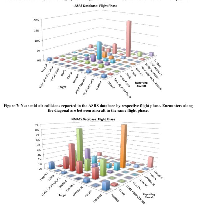
Nearly a quarter of the warnings identified by The Post involved military helicopters, almost half were medical flights, and the rest involved police departments and private operators. wapo.st/40ZnLNi
February 13, 2025 at 6:54 PM
Nearly a quarter of the warnings identified by The Post involved military helicopters, almost half were medical flights, and the rest involved police departments and private operators. wapo.st/40ZnLNi
Thinking about starting a weekly screenshot dump. Random screenshots I've taken over the week.

February 7, 2025 at 3:29 PM
Thinking about starting a weekly screenshot dump. Random screenshots I've taken over the week.

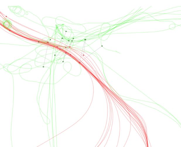
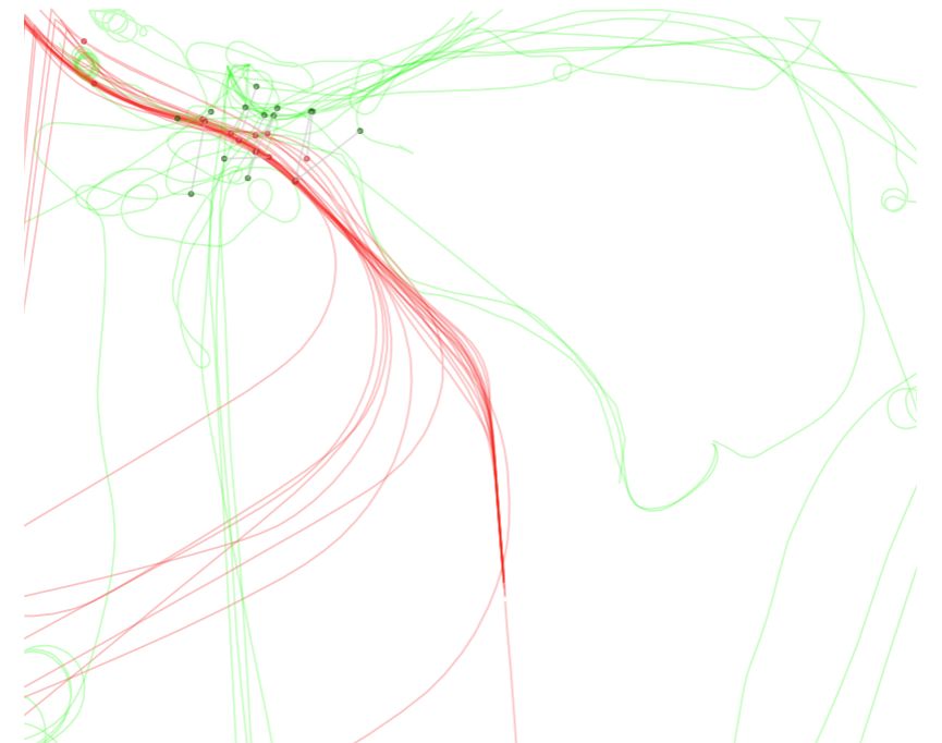
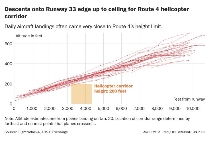
The approach for Runway 33 that Flight 5342 took into Reagan Airport had very little cushion between the helicopter 200-foot corridor's ceiling, according to an analysis of FAA maps. With @byaaroncdavis.bsky.social and Sarah Blaskey wapo.st/3WR04Fx

February 5, 2025 at 3:58 PM
The approach for Runway 33 that Flight 5342 took into Reagan Airport had very little cushion between the helicopter 200-foot corridor's ceiling, according to an analysis of FAA maps. With @byaaroncdavis.bsky.social and Sarah Blaskey wapo.st/3WR04Fx
Let's file a jira ticket!

January 31, 2025 at 10:36 PM
Let's file a jira ticket!
This is from our story five years ago when military helicopters flew into DC to track protestors. The data for the Lakota was excellent, as you can see on the map. The data for the Black Hawk was patchy and inconsistent. We just mapped them based on video.
www.washingtonpost.com/graphics/202...
www.washingtonpost.com/graphics/202...


January 31, 2025 at 2:59 PM
This is from our story five years ago when military helicopters flew into DC to track protestors. The data for the Lakota was excellent, as you can see on the map. The data for the Black Hawk was patchy and inconsistent. We just mapped them based on video.
www.washingtonpost.com/graphics/202...
www.washingtonpost.com/graphics/202...
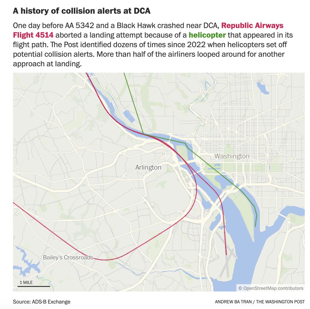
There's going to be a lot of focus on figuring out the altitude of the plane and helicopter that crashed and I wanted to give some context on why these numbers are so tricky to work with.
www.washingtonpost.com/dc-md-va/202...
www.washingtonpost.com/dc-md-va/202...

January 31, 2025 at 2:49 PM
There's going to be a lot of focus on figuring out the altitude of the plane and helicopter that crashed and I wanted to give some context on why these numbers are so tricky to work with.
www.washingtonpost.com/dc-md-va/202...
www.washingtonpost.com/dc-md-va/202...
See agency by agency, the more than one million federal workers who could be affected by Trump’s return-to-office policy. www.washingtonpost.com/politics/202...


January 29, 2025 at 6:20 PM
See agency by agency, the more than one million federal workers who could be affected by Trump’s return-to-office policy. www.washingtonpost.com/politics/202...
Methodology box alert! From "Arrested by AI: Police ignore standards after facial recognition matches"


January 13, 2025 at 7:47 PM
Methodology box alert! From "Arrested by AI: Police ignore standards after facial recognition matches"
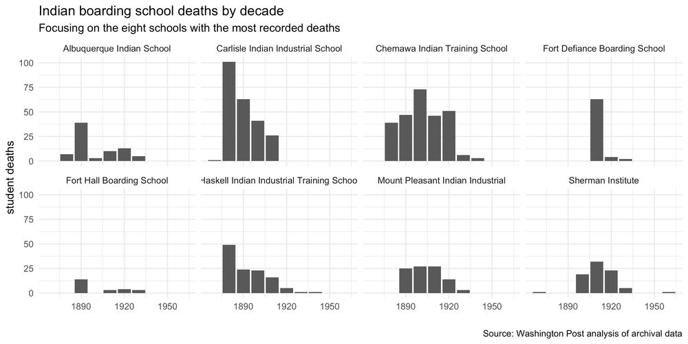
Here's a exploratory data viz comparing the @washingtonpost.com's count of student deaths by tribe compared with the Department of the Interior's

December 23, 2024 at 6:47 PM
Here's a exploratory data viz comparing the @washingtonpost.com's count of student deaths by tribe compared with the Department of the Interior's
Carlisle Indian Industrial School had more than 100 student deaths in a single decade before the 1900s. Chemawa had the second-worst decade starting in 1900 with more than 70 student deaths. But this is all just based on what was documented and what we could track down.
December 23, 2024 at 5:38 PM
Carlisle Indian Industrial School had more than 100 student deaths in a single decade before the 1900s. Chemawa had the second-worst decade starting in 1900 with more than 70 student deaths. But this is all just based on what was documented and what we could track down.