


#30DayMapChallenge - Day 20- Water
Today's map is just lakes in Minnesota. The title was inspired by the Capt Crunch's Oops All Berries. I did play around with the reference scale to try and make the lakes stand out without being overpowering, unlike the box of crunch berries.
Today's map is just lakes in Minnesota. The title was inspired by the Capt Crunch's Oops All Berries. I did play around with the reference scale to try and make the lakes stand out without being overpowering, unlike the box of crunch berries.

November 20, 2025 at 1:39 AM
#30DayMapChallenge - Day 20- Water
Today's map is just lakes in Minnesota. The title was inspired by the Capt Crunch's Oops All Berries. I did play around with the reference scale to try and make the lakes stand out without being overpowering, unlike the box of crunch berries.
Today's map is just lakes in Minnesota. The title was inspired by the Capt Crunch's Oops All Berries. I did play around with the reference scale to try and make the lakes stand out without being overpowering, unlike the box of crunch berries.
#30DayMapChallenge - Day 19 - Projections
Seeing how Alaska gets squished, pulled, and distorted to fit in these different coordinate systems. Definitely explains how I got much of the way through grade school before realizing the sheer size of Alaska.
Seeing how Alaska gets squished, pulled, and distorted to fit in these different coordinate systems. Definitely explains how I got much of the way through grade school before realizing the sheer size of Alaska.

November 19, 2025 at 2:54 AM
#30DayMapChallenge - Day 19 - Projections
Seeing how Alaska gets squished, pulled, and distorted to fit in these different coordinate systems. Definitely explains how I got much of the way through grade school before realizing the sheer size of Alaska.
Seeing how Alaska gets squished, pulled, and distorted to fit in these different coordinate systems. Definitely explains how I got much of the way through grade school before realizing the sheer size of Alaska.
#30DayMapChallenge - Day 18 - Out of this World
I have never heard of Planet Smoothie until yesterday when I asked ChatGPT for some inspiration.
I have never heard of Planet Smoothie until yesterday when I asked ChatGPT for some inspiration.

November 19, 2025 at 12:05 AM
#30DayMapChallenge - Day 18 - Out of this World
I have never heard of Planet Smoothie until yesterday when I asked ChatGPT for some inspiration.
I have never heard of Planet Smoothie until yesterday when I asked ChatGPT for some inspiration.
#30DayMapChallenge - Day 17 - A New Tool
So the new tool / process I tried this time was using the Raster Calculator in QGIS to run NDVI on this orthoimagery dataset that I downloaded for Adams County, Ohio. Why Adams County? That's the "Roulette Part"
So the new tool / process I tried this time was using the Raster Calculator in QGIS to run NDVI on this orthoimagery dataset that I downloaded for Adams County, Ohio. Why Adams County? That's the "Roulette Part"

November 18, 2025 at 3:43 AM
#30DayMapChallenge - Day 17 - A New Tool
So the new tool / process I tried this time was using the Raster Calculator in QGIS to run NDVI on this orthoimagery dataset that I downloaded for Adams County, Ohio. Why Adams County? That's the "Roulette Part"
So the new tool / process I tried this time was using the Raster Calculator in QGIS to run NDVI on this orthoimagery dataset that I downloaded for Adams County, Ohio. Why Adams County? That's the "Roulette Part"
#30DayMapChallenge - Day 16 - Cell
Took the 2024 NCLD data, clipped it to South Dakota, then resampled the data to various resolutions. Nothing fancy...
Took the 2024 NCLD data, clipped it to South Dakota, then resampled the data to various resolutions. Nothing fancy...

November 17, 2025 at 1:08 AM
#30DayMapChallenge - Day 16 - Cell
Took the 2024 NCLD data, clipped it to South Dakota, then resampled the data to various resolutions. Nothing fancy...
Took the 2024 NCLD data, clipped it to South Dakota, then resampled the data to various resolutions. Nothing fancy...
#30DayMapChallenge - Day 15 - Fire
I almost made a map with a more serious tone, but then I came to my senses. Here is another Taco Bell map. Vermont only has 5 locations (same as Taylor, Michigan actually) and if I squint really hard, Vermont is sort of shaped like a torn Fire sauce packet.
I almost made a map with a more serious tone, but then I came to my senses. Here is another Taco Bell map. Vermont only has 5 locations (same as Taylor, Michigan actually) and if I squint really hard, Vermont is sort of shaped like a torn Fire sauce packet.

November 15, 2025 at 3:44 AM
#30DayMapChallenge - Day 15 - Fire
I almost made a map with a more serious tone, but then I came to my senses. Here is another Taco Bell map. Vermont only has 5 locations (same as Taylor, Michigan actually) and if I squint really hard, Vermont is sort of shaped like a torn Fire sauce packet.
I almost made a map with a more serious tone, but then I came to my senses. Here is another Taco Bell map. Vermont only has 5 locations (same as Taylor, Michigan actually) and if I squint really hard, Vermont is sort of shaped like a torn Fire sauce packet.
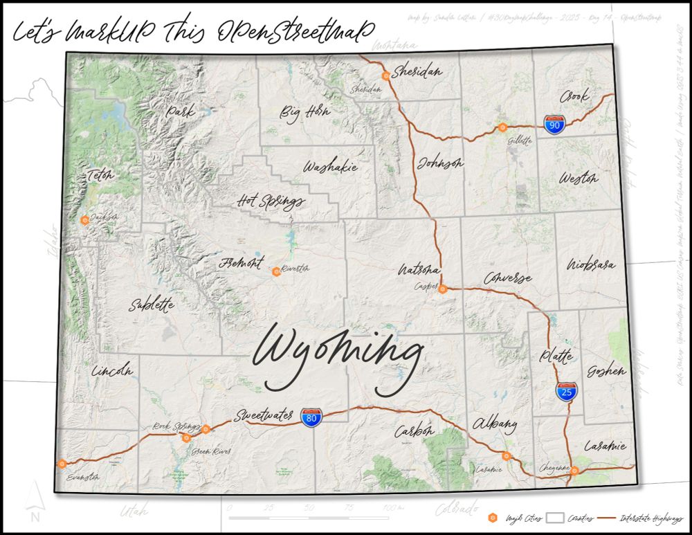
#30DayMapChallenge - Day 14 - OpenStreetmap
I really wasn't sure how to approach this theme so I started with a base map layer from OpenStreetMap. Then I just sort of "scribbled" all over it. No real direction, just playing around with layers and fonts.
I really wasn't sure how to approach this theme so I started with a base map layer from OpenStreetMap. Then I just sort of "scribbled" all over it. No real direction, just playing around with layers and fonts.
November 14, 2025 at 3:21 AM
#30DayMapChallenge - Day 14 - OpenStreetmap
I really wasn't sure how to approach this theme so I started with a base map layer from OpenStreetMap. Then I just sort of "scribbled" all over it. No real direction, just playing around with layers and fonts.
I really wasn't sure how to approach this theme so I started with a base map layer from OpenStreetMap. Then I just sort of "scribbled" all over it. No real direction, just playing around with layers and fonts.
#30DayMapChallenge - Day 13 - 10 Minute Map
10 Minute Map? Well...probably more like 12 minute map.
Quick and dirty map? Definitely.
There is an obscure music pun hidden in the map if you can find it.
10 Minute Map? Well...probably more like 12 minute map.
Quick and dirty map? Definitely.
There is an obscure music pun hidden in the map if you can find it.

November 13, 2025 at 3:08 AM
#30DayMapChallenge - Day 13 - 10 Minute Map
10 Minute Map? Well...probably more like 12 minute map.
Quick and dirty map? Definitely.
There is an obscure music pun hidden in the map if you can find it.
10 Minute Map? Well...probably more like 12 minute map.
Quick and dirty map? Definitely.
There is an obscure music pun hidden in the map if you can find it.
#30DayMapChallenge - Day 12 - Map from 2125
This is by far the most challenging day for me during this challenge; I wasn't sure how to interpret it. I chose make a hypothetical high speed rail map of the lower 48 states of the US. I'm not sure how I feel about it, but there is always tomorrow.
This is by far the most challenging day for me during this challenge; I wasn't sure how to interpret it. I chose make a hypothetical high speed rail map of the lower 48 states of the US. I'm not sure how I feel about it, but there is always tomorrow.

November 12, 2025 at 3:20 AM
#30DayMapChallenge - Day 12 - Map from 2125
This is by far the most challenging day for me during this challenge; I wasn't sure how to interpret it. I chose make a hypothetical high speed rail map of the lower 48 states of the US. I'm not sure how I feel about it, but there is always tomorrow.
This is by far the most challenging day for me during this challenge; I wasn't sure how to interpret it. I chose make a hypothetical high speed rail map of the lower 48 states of the US. I'm not sure how I feel about it, but there is always tomorrow.
#30DayMapChallenge - Day 11 - Minimal Map
For today's map, I kept things minimal (including the effort).
For today's map, I kept things minimal (including the effort).

November 11, 2025 at 3:18 AM
#30DayMapChallenge - Day 11 - Minimal Map
For today's map, I kept things minimal (including the effort).
For today's map, I kept things minimal (including the effort).
#30DayMapChallenge - Day 10 - Air
Woke up on Sunday morning to find snow on the ground with flurries throughout the day. Needless to say, this map idea was inspired by Sunday's weather. Brrrrr....🥶
Woke up on Sunday morning to find snow on the ground with flurries throughout the day. Needless to say, this map idea was inspired by Sunday's weather. Brrrrr....🥶

November 10, 2025 at 1:44 AM
#30DayMapChallenge - Day 10 - Air
Woke up on Sunday morning to find snow on the ground with flurries throughout the day. Needless to say, this map idea was inspired by Sunday's weather. Brrrrr....🥶
Woke up on Sunday morning to find snow on the ground with flurries throughout the day. Needless to say, this map idea was inspired by Sunday's weather. Brrrrr....🥶
#30DayMapChallenge - Day 9 - Analog
I shall call it LEGO-HIO! I've made a few LEGO maps in ArcGIS Pro, so why not try it with real LEGO. Would have been nice if the colors matched but at least I had enough flowers for the big cities. 100% FUN!
I shall call it LEGO-HIO! I've made a few LEGO maps in ArcGIS Pro, so why not try it with real LEGO. Would have been nice if the colors matched but at least I had enough flowers for the big cities. 100% FUN!

November 9, 2025 at 3:41 AM
#30DayMapChallenge - Day 9 - Analog
I shall call it LEGO-HIO! I've made a few LEGO maps in ArcGIS Pro, so why not try it with real LEGO. Would have been nice if the colors matched but at least I had enough flowers for the big cities. 100% FUN!
I shall call it LEGO-HIO! I've made a few LEGO maps in ArcGIS Pro, so why not try it with real LEGO. Would have been nice if the colors matched but at least I had enough flowers for the big cities. 100% FUN!
#30DayMapChallenge - Day 8 - Urban
Today I decided to just experiment and play around with visualization, nothing too crazy or purposeful. Obviously I am focusing on Detroit but several suburbs are also included. I did highlight the road network and freeways for some razzle dazzle.
Today I decided to just experiment and play around with visualization, nothing too crazy or purposeful. Obviously I am focusing on Detroit but several suburbs are also included. I did highlight the road network and freeways for some razzle dazzle.

November 8, 2025 at 4:22 AM
#30DayMapChallenge - Day 8 - Urban
Today I decided to just experiment and play around with visualization, nothing too crazy or purposeful. Obviously I am focusing on Detroit but several suburbs are also included. I did highlight the road network and freeways for some razzle dazzle.
Today I decided to just experiment and play around with visualization, nothing too crazy or purposeful. Obviously I am focusing on Detroit but several suburbs are also included. I did highlight the road network and freeways for some razzle dazzle.
#30DayMapChallenge - Day 7 - Accessibility
In 2010, I went on a weekend trip to Chicago. This trip left a lasting impression on me of how a decent rail system can make a large city so accessible without a car. This map shows a one mile buffer from the "L".
In 2010, I went on a weekend trip to Chicago. This trip left a lasting impression on me of how a decent rail system can make a large city so accessible without a car. This map shows a one mile buffer from the "L".

November 7, 2025 at 2:59 AM
#30DayMapChallenge - Day 7 - Accessibility
In 2010, I went on a weekend trip to Chicago. This trip left a lasting impression on me of how a decent rail system can make a large city so accessible without a car. This map shows a one mile buffer from the "L".
In 2010, I went on a weekend trip to Chicago. This trip left a lasting impression on me of how a decent rail system can make a large city so accessible without a car. This map shows a one mile buffer from the "L".
#30DayMapChallenge - Day 6 - Dimensions
Today I am exploring the "time" dimension and exploring the decline of Rite Aid within Michigan and Ohio. In the end, Rite Aid closed of their all stores.
Today I am exploring the "time" dimension and exploring the decline of Rite Aid within Michigan and Ohio. In the end, Rite Aid closed of their all stores.

November 6, 2025 at 1:43 AM
#30DayMapChallenge - Day 6 - Dimensions
Today I am exploring the "time" dimension and exploring the decline of Rite Aid within Michigan and Ohio. In the end, Rite Aid closed of their all stores.
Today I am exploring the "time" dimension and exploring the decline of Rite Aid within Michigan and Ohio. In the end, Rite Aid closed of their all stores.
#30DayMapChallenge - Day 5 - Earth
I always thought these types of elevation maps were really cool. I figured why not revisit it (I made one last year for New Hampshire). Why Iowa? Why not. I did have to add a "multiplier" to the elevation to try and make the effect look a bit more visible.
I always thought these types of elevation maps were really cool. I figured why not revisit it (I made one last year for New Hampshire). Why Iowa? Why not. I did have to add a "multiplier" to the elevation to try and make the effect look a bit more visible.

November 5, 2025 at 1:50 AM
#30DayMapChallenge - Day 5 - Earth
I always thought these types of elevation maps were really cool. I figured why not revisit it (I made one last year for New Hampshire). Why Iowa? Why not. I did have to add a "multiplier" to the elevation to try and make the effect look a bit more visible.
I always thought these types of elevation maps were really cool. I figured why not revisit it (I made one last year for New Hampshire). Why Iowa? Why not. I did have to add a "multiplier" to the elevation to try and make the effect look a bit more visible.
#30DayMapChallenge - Day 4 - My Data
Cars and traveling are some of my favorite things during my downtime. My wife is not a huge fan of air travel so most of our traveling is done by car. This map shows the five cars I have owned and the states where I have driven them.
Cars and traveling are some of my favorite things during my downtime. My wife is not a huge fan of air travel so most of our traveling is done by car. This map shows the five cars I have owned and the states where I have driven them.

November 4, 2025 at 1:02 AM
#30DayMapChallenge - Day 4 - My Data
Cars and traveling are some of my favorite things during my downtime. My wife is not a huge fan of air travel so most of our traveling is done by car. This map shows the five cars I have owned and the states where I have driven them.
Cars and traveling are some of my favorite things during my downtime. My wife is not a huge fan of air travel so most of our traveling is done by car. This map shows the five cars I have owned and the states where I have driven them.
#30DayMapChallenge - Day 3 - Polygons
Today is a mashup of two things I enjoy making maps about, Taco Bell locations and using a state as a unit of measurement.
Today is a mashup of two things I enjoy making maps about, Taco Bell locations and using a state as a unit of measurement.

November 3, 2025 at 3:37 AM
#30DayMapChallenge - Day 3 - Polygons
Today is a mashup of two things I enjoy making maps about, Taco Bell locations and using a state as a unit of measurement.
Today is a mashup of two things I enjoy making maps about, Taco Bell locations and using a state as a unit of measurement.
Day 2 - Lines
In November 2015, my wife and I took a road trip from Michigan to the Grand Canyon. While on our way home, we drove down US 491 to pick up Interstate 40 in Gallop, New Mexico. I didn't realize that I had actually driven on US 666. #30DayMapChallenge
In November 2015, my wife and I took a road trip from Michigan to the Grand Canyon. While on our way home, we drove down US 491 to pick up Interstate 40 in Gallop, New Mexico. I didn't realize that I had actually driven on US 666. #30DayMapChallenge

November 2, 2025 at 3:41 AM
Day 2 - Lines
In November 2015, my wife and I took a road trip from Michigan to the Grand Canyon. While on our way home, we drove down US 491 to pick up Interstate 40 in Gallop, New Mexico. I didn't realize that I had actually driven on US 666. #30DayMapChallenge
In November 2015, my wife and I took a road trip from Michigan to the Grand Canyon. While on our way home, we drove down US 491 to pick up Interstate 40 in Gallop, New Mexico. I didn't realize that I had actually driven on US 666. #30DayMapChallenge
Day 1 - Points
It is November and with that comes another #30DayMapChallenge While I try not to make too many serious maps, I did try twice as hard to stay on topic with this one. I was a little confused by Grosse Pointe Shores being a city with "village" in the name.
It is November and with that comes another #30DayMapChallenge While I try not to make too many serious maps, I did try twice as hard to stay on topic with this one. I was a little confused by Grosse Pointe Shores being a city with "village" in the name.

November 2, 2025 at 3:38 AM
Day 1 - Points
It is November and with that comes another #30DayMapChallenge While I try not to make too many serious maps, I did try twice as hard to stay on topic with this one. I was a little confused by Grosse Pointe Shores being a city with "village" in the name.
It is November and with that comes another #30DayMapChallenge While I try not to make too many serious maps, I did try twice as hard to stay on topic with this one. I was a little confused by Grosse Pointe Shores being a city with "village" in the name.
While I’m not a football fan, I was hoping that the home team would make it all the way and give me a reason to update this map that I made a couple of years ago. That said, they did have a great season and exceeded my expectations. 👍

January 19, 2025 at 8:39 PM
While I’m not a football fan, I was hoping that the home team would make it all the way and give me a reason to update this map that I made a couple of years ago. That said, they did have a great season and exceeded my expectations. 👍
#30DayMapChallenge - Day 22 Two Colors
The color green seems to be a big part of the identity of Vermont (from what I could tell), though it was covered in yellows, oranges, and reds when I visited last month. This map was inspired by the state’s license plate #QGIS #gischat
The color green seems to be a big part of the identity of Vermont (from what I could tell), though it was covered in yellows, oranges, and reds when I visited last month. This map was inspired by the state’s license plate #QGIS #gischat

November 23, 2024 at 2:24 AM
#30DayMapChallenge - Day 22 Two Colors
The color green seems to be a big part of the identity of Vermont (from what I could tell), though it was covered in yellows, oranges, and reds when I visited last month. This map was inspired by the state’s license plate #QGIS #gischat
The color green seems to be a big part of the identity of Vermont (from what I could tell), though it was covered in yellows, oranges, and reds when I visited last month. This map was inspired by the state’s license plate #QGIS #gischat

November 19, 2024 at 5:45 PM
#30DayMapChallenge - Day 18 3D
Downloaded some #lidar data for the Ambassador Bridge between Detroit, MI and Windsor, ON. Thought it might be fun to try and make a 3D map from it. It didn't disappoint. 🙂
#QGIS
Downloaded some #lidar data for the Ambassador Bridge between Detroit, MI and Windsor, ON. Thought it might be fun to try and make a 3D map from it. It didn't disappoint. 🙂
#QGIS

November 19, 2024 at 3:13 AM
#30DayMapChallenge - Day 18 3D
Downloaded some #lidar data for the Ambassador Bridge between Detroit, MI and Windsor, ON. Thought it might be fun to try and make a 3D map from it. It didn't disappoint. 🙂
#QGIS
Downloaded some #lidar data for the Ambassador Bridge between Detroit, MI and Windsor, ON. Thought it might be fun to try and make a 3D map from it. It didn't disappoint. 🙂
#QGIS
I have been participating in the #30DayMapChallenge this November. Here are some of the maps that I have completed so far. I made them using #QGIS as I’m a Mac user at home.


November 17, 2024 at 5:20 PM
I have been participating in the #30DayMapChallenge this November. Here are some of the maps that I have completed so far. I made them using #QGIS as I’m a Mac user at home.