WeatherTiger
banner
weathertiger.bsky.social
WeatherTiger
@weathertiger.bsky.social
1.6K followers 130 following 210 posts
Daily tropical newsletter at weathertiger.substack.com. Posts by Dr. Ryan Truchelut, weatherman, inframarathoner, dad, dad-humorist.
Posts Media Videos Starter Packs
With the NHC predicting #TropicalStormMelissa to become a major #hurricane next week, it looks to do so further east than most late season Cat 3+ storms.

The western/west-central Caribbean, where #Melissa will be, are most common locations for rapid intensification in late October or November.
If the 2025 hurricane season only had one last shot to threaten land, would it seize it, or just let it slip? With La Niña back again, and a vigorous tropical wave heading for the Caribbean, we’ll need to keep an eye out to our south. Climatology says any U.S. threat is unlikely, but not impossible.
Spanish for The Niña: Hurricane Watch Weekly Column for October 16th
The official onset of La Niña conditions may boost late-season development prospects in the Caribbean next week, which is an area worth watching for U.S. interests.
weathertiger.substack.com
Had a chance to discuss the strong coastal low set to impact the East Coast, what to expect over the rest of the 2025 hurricane season, and, of course, to review and assign a numerical rating to Taylor Swift's "The Life of A Showgirl" live on Fox Weather today. Fun interview!
WeatherTiger Discusses Late Season Hurricane Risks, Taylor Swift on Fox Weather
YouTube video by Weather Tiger, LLC
www.youtube.com
Is hurricane season CANCELLED!?

In 2025, we’ve told tropical cyclones to leave us alone and they have. With no hint the next few weeks won’t keep it 100 and most U.S. landfalls post-10/15 caused by lumbering Central American Gyres, this week's column takes a close look at the Life of a Slow Gyre.
A Swiftly Tilting Gyre: Hurricane Watch Weekly Column for October 8th
With no U.S. threat from Jerry, I take a look at the life of a Central American Gyre and whether one is likely to develop this October.
weathertiger.substack.com
Very cool long water vapor loop of #Humberto and #Imelda between September 28th and October 1st from College of DuPage, btw.
Wrapping up Humbertimelda mania, looking at what the home stretch of hurricane season is historically packing, and checking how the forecast for the next few weeks lines up with climatology.

All that plus spooky, scary skeletons in this week’s WeatherTiger hurricane column:
Whirlwind Tour: Hurricane Watch Weekly Column for October 1st
Wrapping up Humbertimelda mania and looking at historical October hurricane risks.
weathertiger.substack.com
Potential Tropical Cyclone 9 will strengthen to a tropical storm and move north-northwest through the Bahamas this weekend.

Our latest on an uncertain forecast for potential coastal rain and wind impacts for Florida north to the Carolinas:
WeatherTiger's Potential Tropical Cyclone Nine Forecast for September 27th
PTC 9 is expected to approach the Carolinas in around 3 days, with an uncertain forecast thereafter.
weathertiger.substack.com
TS #Humberto and #Invest94L continue to be features to watch closely. The bigger threat, Invest #94L, should follow a steering channel east of #Florida this weekend. #Carolinas have a higher chance of a direct landfall early next week.

Thursday update here: weathertiger.substack.com/p/dont-call-...
One year after Helene/Milton Hurricane Hell Fortnight '24, milder double trouble is here as #Invest93L & #Invest94L may track close enough to interact this week. Odds tilt away from major U.S. impacts, but worth watching from #Florida to the Carolinas.

The latest on a possible Hurricane Heck Week:
Folie à Deux: Hurricane Watch Weekly Column for September 24th
Making sense of the chance that two tropical systems interact east of Florida early next week, and what that means for possible U.S. weather impacts.
weathertiger.substack.com
For the 1st time in 84 years, correction, 3 weeks, there is a storm in the Atlantic: Gabrielle, a strung-out mess that poses no risk other than to Bermuda.

With a quiet Atlantic continuing, I'm taking a deep dive into AI weather/hurricane prediction this week. Am I about to be replaced by Skynet?
Never Ending Math Equation: Hurricane Watch Weekly Column for September 17th
TS Gabrielle forms but is no threat, as we look at how AI is making an impact on hurricane forecasts.
weathertiger.substack.com
Thanks for reading and here's hoping that the luck of the 1st half of hurricane season can last through the 2nd half. After a record 10 major hurricanes in 9 yrs we need a break on the Gulf Coast.

Check out my full analysis of late-season landfall risks here:
Stolen Thunder: Hurricane Watch Weekly Column for September 10th
Hurricane season has fallen. Can it get up? We develop a new model to address that question.
weathertiger.substack.com
So, the war between favorable ocean & hostile atmospheric conditions may persist in the final third of hurricane season and U.S. landfall risks.

WeatherTiger's model of post-9/20 Gulf/W. Carib tropical activity is a bit above normal but not nearly as busy as 2020/24 late seasons.
The 2nd key predictor of post-9/20 Gulf/W. Carib activity is September ridging over the SE United States. More Sept. ridging is correlated with more hurricane activity.

Sept. 2025 has been the exact opposite of this pattern so far: persistent deep troughing over the eastern U.S.
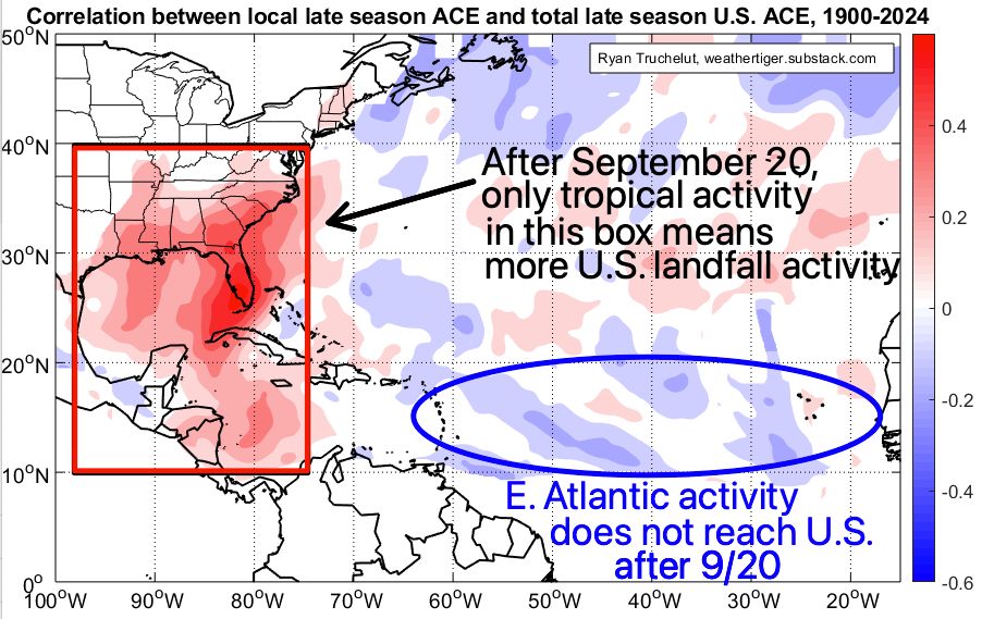
Only Gulf & W. Caribbean (west of 75W) activity post-9/20 translates to more late season U.S. landfalls.

SSTs are 1 key predictor of late season Gulf/Carib storms. More activity is linked to warm Caribbean/C. Atlantic, colder Pacific/Nina conditions. Sept. 2025 resembles that.
Conditions in the east Atlantic may become more conducive for waves to develop in the next week.

But that may not translate to U.S. landfall risks. After 9/20, more hurricane activity east of the Lesser Antilles is actually linked to slightly fewer late-season U.S. landfalls.
In short, nearly the entire Atlantic Basin has seen less convection (tstorms) than normal over the last month because of persistent sinking air aloft and mid-level dry air incursions.

Convection is the building block of tropical cyclones, so no convection, no hurricanes. 2/7
If you follow the Tropical Atlantic, you might be confused like our friend Vincent Vega here by the lack of any named storms since August 28th, a timeframe that is the climatological peak of #hurricane season.

So what's going on, and will it continue? Thread: (1/7)
If like Travolta here, you're confused by the quiet peak week of hurricane season, we’ve got you covered. Today’s column breaks down the reasons for this lull and rolls out fresh predictions from our model of late-season U.S. landfall risks.

Bottom line, stay light on your feet like Johnny.
Stolen Thunder: Hurricane Watch Weekly Column for September 10th
Hurricane season has fallen. Can it get up? We develop a new model to address that question.
weathertiger.substack.com
[Annual post]

Convection crippled by the dry air that keeps on blowin'
Subsidence imposin'
And we

Keep bleeding, keep, keep bleeding ACE
And we keep bleeding, keep, keep bleeding ACE
Keep bleeding, keep, keep bleeding ACE

Shear cuts waves open
With Invest 91L succumbing to dry air and subsidence and no longer a threat to develop, here's a look at this morning's NHC Tropical Weather Outlook:
It's been a quiet, hopeful first half of #hurricane season, but there are possible signs of trouble brewing for the second half.

This week’s column discusses a tropical wave in the eastern Atlantic likely to become the next tropical storm, as well as updated U.S. seasonal landfall probabilities.
Halftime Show: Hurricane Watch Weekly Column for September 3rd
Monitoring a potential hurricane threat to the Antilles as we gear up for what will likely be a busy second half of hurricane season.
weathertiger.substack.com
It's always a happy Labor Day weekend without a hurricane. Even high rain chances for Florida, beats the historical alternative.

An oddly quiet week in the Tropics is a chance to look back at Katrina and ahead to September. Cherish the reprieve, because climatology tells us it won’t last forever.
ACE/Off: Hurricane Watch Weekly Column for August 27th
An oddly quiet week in the Tropics is a chance to look back at Katrina and ahead to September hurricane history.
weathertiger.substack.com
Atlantic Tropical development is unlikely in the last week of August.

That's a little unusual: over the last 75 years, at least one tropical storm has formed ~60% of the time. At least one hurricane developed in ~40% of seasons.

Nice easy week. Cherish it while it lasts.