


Valerio Marsocci
@valeriomarsocci.bsky.social
🌏🌱
trying to make Geospatial Foundation Models work
Research Fellow at @ESA PhiLab
Previously at @KULeuven, @Cnam
PhD in Data Science at @Sapienza
website: https://sites.google.com/uniroma1.it/valeriomarsocci
#AI4EO #GeoAI #SSL4EO
trying to make Geospatial Foundation Models work
Research Fellow at @ESA PhiLab
Previously at @KULeuven, @Cnam
PhD in Data Science at @Sapienza
website: https://sites.google.com/uniroma1.it/valeriomarsocci
#AI4EO #GeoAI #SSL4EO
Pinned
Hi everyone! 🚀 Happy to be here
I am Valerio, from Rome (IT), doing a postdoc at KU Leuven
I am working on benchmarking and adapting geospatial foundation models for environmental tasks🌏
Hope to connect with Earth Observation and Deep Learning enthusiasts here! ✨
Follow my #50paperschallenge
I am Valerio, from Rome (IT), doing a postdoc at KU Leuven
I am working on benchmarking and adapting geospatial foundation models for environmental tasks🌏
Hope to connect with Earth Observation and Deep Learning enthusiasts here! ✨
Follow my #50paperschallenge
#8 Copernicus-FM
This paper introduces: a) a new pre-training dataset; b) a new benchmark dataset; c) a GFM, all based on a diverse set of Copernicus data.
⬆️: really appreciate the grid embeddings part
⬇️: some doubts about claims about generalizability
arxiv.org/pdf/2503.11849
This paper introduces: a) a new pre-training dataset; b) a new benchmark dataset; c) a GFM, all based on a diverse set of Copernicus data.
⬆️: really appreciate the grid embeddings part
⬇️: some doubts about claims about generalizability
arxiv.org/pdf/2503.11849

March 27, 2025 at 9:30 AM
#8 Copernicus-FM
This paper introduces: a) a new pre-training dataset; b) a new benchmark dataset; c) a GFM, all based on a diverse set of Copernicus data.
⬆️: really appreciate the grid embeddings part
⬇️: some doubts about claims about generalizability
arxiv.org/pdf/2503.11849
This paper introduces: a) a new pre-training dataset; b) a new benchmark dataset; c) a GFM, all based on a diverse set of Copernicus data.
⬆️: really appreciate the grid embeddings part
⬇️: some doubts about claims about generalizability
arxiv.org/pdf/2503.11849
🔥 🎯 Parameter-Efficient Adaptation of Geospatial Foundation Models through Embedding Deflection (#7)
New preprint around :)
Incorporating inductive biases specific to MSI can enhance the fine-tuning of large Earth observation models, pre-trained on RGB
arxiv.org/pdf/2503.09493
New preprint around :)
Incorporating inductive biases specific to MSI can enhance the fine-tuning of large Earth observation models, pre-trained on RGB
arxiv.org/pdf/2503.09493

March 17, 2025 at 10:18 AM
🔥 🎯 Parameter-Efficient Adaptation of Geospatial Foundation Models through Embedding Deflection (#7)
New preprint around :)
Incorporating inductive biases specific to MSI can enhance the fine-tuning of large Earth observation models, pre-trained on RGB
arxiv.org/pdf/2503.09493
New preprint around :)
Incorporating inductive biases specific to MSI can enhance the fine-tuning of large Earth observation models, pre-trained on RGB
arxiv.org/pdf/2503.09493
#6 Lossy Neural Compression for Geospatial Analytics
The authors introduce NC and discuss the characteristics of EO and climate data, w.r.t natural images
⬆️: great entry point
⬇️: no baseline exps
arxiv.org/pdf/2503.01505
The authors introduce NC and discuss the characteristics of EO and climate data, w.r.t natural images
⬆️: great entry point
⬇️: no baseline exps
arxiv.org/pdf/2503.01505

March 10, 2025 at 1:00 PM
#6 Lossy Neural Compression for Geospatial Analytics
The authors introduce NC and discuss the characteristics of EO and climate data, w.r.t natural images
⬆️: great entry point
⬇️: no baseline exps
arxiv.org/pdf/2503.01505
The authors introduce NC and discuss the characteristics of EO and climate data, w.r.t natural images
⬆️: great entry point
⬇️: no baseline exps
arxiv.org/pdf/2503.01505
#5 Is SSL on Satellite Imagery Better than ImageNet? A Systematic Study with Sentinel-2
This study pretrains two SSL methods on ImageNet and GeoNet. The improvement with GeoNet is minimal.
⬆️ useful to reduce computation?
⬇️ more considerations about the resolutions?
arxiv.org/pdf/2502.10669
This study pretrains two SSL methods on ImageNet and GeoNet. The improvement with GeoNet is minimal.
⬆️ useful to reduce computation?
⬇️ more considerations about the resolutions?
arxiv.org/pdf/2502.10669

February 24, 2025 at 9:08 AM
#5 Is SSL on Satellite Imagery Better than ImageNet? A Systematic Study with Sentinel-2
This study pretrains two SSL methods on ImageNet and GeoNet. The improvement with GeoNet is minimal.
⬆️ useful to reduce computation?
⬇️ more considerations about the resolutions?
arxiv.org/pdf/2502.10669
This study pretrains two SSL methods on ImageNet and GeoNet. The improvement with GeoNet is minimal.
⬆️ useful to reduce computation?
⬇️ more considerations about the resolutions?
arxiv.org/pdf/2502.10669
#4 Galileo
Galileo is a family of pretrained RS models designed to flexibly process multimodal RS data. It has two loss: one in the pixel space, one in the latent space.
⬆️: multi-modal/temporal/sensor
⬇️: why just using Sentinel data?
arxiv.org/pdf/2502.09356
Galileo is a family of pretrained RS models designed to flexibly process multimodal RS data. It has two loss: one in the pixel space, one in the latent space.
⬆️: multi-modal/temporal/sensor
⬇️: why just using Sentinel data?
arxiv.org/pdf/2502.09356

February 14, 2025 at 8:43 AM
#4 Galileo
Galileo is a family of pretrained RS models designed to flexibly process multimodal RS data. It has two loss: one in the pixel space, one in the latent space.
⬆️: multi-modal/temporal/sensor
⬇️: why just using Sentinel data?
arxiv.org/pdf/2502.09356
Galileo is a family of pretrained RS models designed to flexibly process multimodal RS data. It has two loss: one in the pixel space, one in the latent space.
⬆️: multi-modal/temporal/sensor
⬇️: why just using Sentinel data?
arxiv.org/pdf/2502.09356
#3 GlaViTU
This paper presents a novel world-wide dataset and a novel convolutional-transformer, named Glacier-VisionTransformer-U-Net (GlaViTU), for multitemporal and global glacier mapping.
⬆️ relevant task and nice results
⬇️ weak zero-shot transferability?
www.nature.com/articles/s41...
This paper presents a novel world-wide dataset and a novel convolutional-transformer, named Glacier-VisionTransformer-U-Net (GlaViTU), for multitemporal and global glacier mapping.
⬆️ relevant task and nice results
⬇️ weak zero-shot transferability?
www.nature.com/articles/s41...

Globally scalable glacier mapping by deep learning matches expert delineation accuracy - Nature Communications
A deep learning model using open satellite data for scalable, global glacier mapping is developed. This model matches expert-level accuracy, facilitating more reliable glacier monitoring to support cl...
www.nature.com
February 5, 2025 at 1:24 PM
#3 GlaViTU
This paper presents a novel world-wide dataset and a novel convolutional-transformer, named Glacier-VisionTransformer-U-Net (GlaViTU), for multitemporal and global glacier mapping.
⬆️ relevant task and nice results
⬇️ weak zero-shot transferability?
www.nature.com/articles/s41...
This paper presents a novel world-wide dataset and a novel convolutional-transformer, named Glacier-VisionTransformer-U-Net (GlaViTU), for multitemporal and global glacier mapping.
⬆️ relevant task and nice results
⬇️ weak zero-shot transferability?
www.nature.com/articles/s41...
#2 Can Location Embeddings Enhance Super-Resolution of Satellite Imagery?
It looks like they can :)
⬆️: validating it on a real-world task
⬇️: is it super-resolution or mapping S2 to NAIP?
arxiv.org/pdf/2501.15847
It looks like they can :)
⬆️: validating it on a real-world task
⬇️: is it super-resolution or mapping S2 to NAIP?
arxiv.org/pdf/2501.15847

January 30, 2025 at 9:59 AM
#2 Can Location Embeddings Enhance Super-Resolution of Satellite Imagery?
It looks like they can :)
⬆️: validating it on a real-world task
⬇️: is it super-resolution or mapping S2 to NAIP?
arxiv.org/pdf/2501.15847
It looks like they can :)
⬆️: validating it on a real-world task
⬇️: is it super-resolution or mapping S2 to NAIP?
arxiv.org/pdf/2501.15847
#1 Diffusion Models for RS
This paper provides a comprehensive review of the applications of diffusion models in remote sensing
⬆️ excellent entry point
⬇️ not sure about the statement about the "inherent denoising ability" of diffusion models
arxiv.org/abs/2404.08926
This paper provides a comprehensive review of the applications of diffusion models in remote sensing
⬆️ excellent entry point
⬇️ not sure about the statement about the "inherent denoising ability" of diffusion models
arxiv.org/abs/2404.08926

January 21, 2025 at 1:44 PM
#1 Diffusion Models for RS
This paper provides a comprehensive review of the applications of diffusion models in remote sensing
⬆️ excellent entry point
⬇️ not sure about the statement about the "inherent denoising ability" of diffusion models
arxiv.org/abs/2404.08926
This paper provides a comprehensive review of the applications of diffusion models in remote sensing
⬆️ excellent entry point
⬇️ not sure about the statement about the "inherent denoising ability" of diffusion models
arxiv.org/abs/2404.08926
Hellooooo 🚀
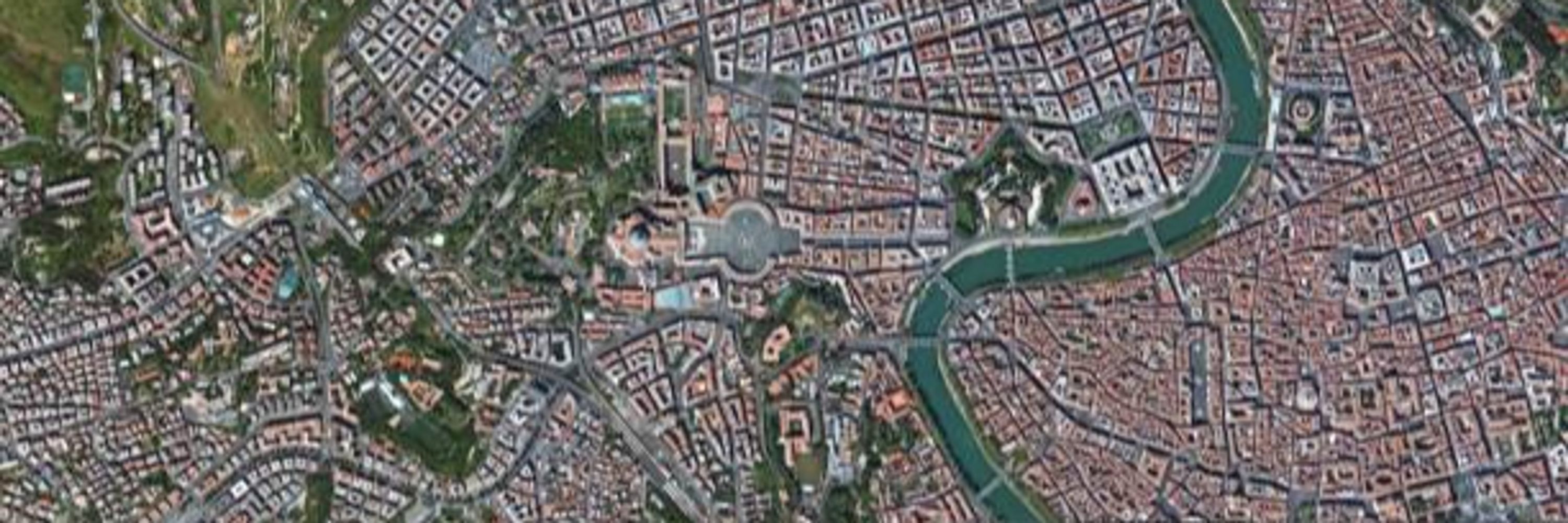
I'll make it swift: I have just started my new position as Internal Research Fellow at European Space Agency - ESA Phi-Lab
I am very happy because it looks like a great place where to do research and because I am back in my beloved hometown, Rome 😍
I'll make it swift: I have just started my new position as Internal Research Fellow at European Space Agency - ESA Phi-Lab
I am very happy because it looks like a great place where to do research and because I am back in my beloved hometown, Rome 😍
January 16, 2025 at 2:16 PM
Hellooooo 🚀
I'll make it swift: I have just started my new position as Internal Research Fellow at European Space Agency - ESA Phi-Lab
I am very happy because it looks like a great place where to do research and because I am back in my beloved hometown, Rome 😍
I'll make it swift: I have just started my new position as Internal Research Fellow at European Space Agency - ESA Phi-Lab
I am very happy because it looks like a great place where to do research and because I am back in my beloved hometown, Rome 😍
Back on social, after a break (can you guess where?)
Last year I decided to do a #50paperschallenge
I ended up with 43. Still:
🥵 I read more than 50 papers. I just didn't post all
😇 the strategy worked independently of the posted ones
For this reason, this year I will do a #40paperschallenge!
Last year I decided to do a #50paperschallenge
I ended up with 43. Still:
🥵 I read more than 50 papers. I just didn't post all
😇 the strategy worked independently of the posted ones
For this reason, this year I will do a #40paperschallenge!

January 14, 2025 at 2:35 PM
Back on social, after a break (can you guess where?)
Last year I decided to do a #50paperschallenge
I ended up with 43. Still:
🥵 I read more than 50 papers. I just didn't post all
😇 the strategy worked independently of the posted ones
For this reason, this year I will do a #40paperschallenge!
Last year I decided to do a #50paperschallenge
I ended up with 43. Still:
🥵 I read more than 50 papers. I just didn't post all
😇 the strategy worked independently of the posted ones
For this reason, this year I will do a #40paperschallenge!
#41 Beyond Grid Data
GNNs open new possibilities for EO, handling irregular, multi-source datasets (e.g. point clouds) for smarter weather forecasts, disaster relief, etc..
⬆️: excels at non-Euclidean spatial data
⬇️: limited scalability across diverse data (?)
arxiv.org/abs/2411.03223
GNNs open new possibilities for EO, handling irregular, multi-source datasets (e.g. point clouds) for smarter weather forecasts, disaster relief, etc..
⬆️: excels at non-Euclidean spatial data
⬇️: limited scalability across diverse data (?)
arxiv.org/abs/2411.03223

December 12, 2024 at 1:33 PM
#41 Beyond Grid Data
GNNs open new possibilities for EO, handling irregular, multi-source datasets (e.g. point clouds) for smarter weather forecasts, disaster relief, etc..
⬆️: excels at non-Euclidean spatial data
⬇️: limited scalability across diverse data (?)
arxiv.org/abs/2411.03223
GNNs open new possibilities for EO, handling irregular, multi-source datasets (e.g. point clouds) for smarter weather forecasts, disaster relief, etc..
⬆️: excels at non-Euclidean spatial data
⬇️: limited scalability across diverse data (?)
arxiv.org/abs/2411.03223
🚀🚀🌏
Are geospatial foundation models really impactful?
Check it in our new pre-print!
Welcome to **PANGAEA: a global and inclusive benchmark for GFMs**
arxiv.org/abs/2412.04204
Check also the public GitHub repo (other news/updates soon):
github.com/VMarsocci/pa...
a short thread 🧵
Are geospatial foundation models really impactful?
Check it in our new pre-print!
Welcome to **PANGAEA: a global and inclusive benchmark for GFMs**
arxiv.org/abs/2412.04204
Check also the public GitHub repo (other news/updates soon):
github.com/VMarsocci/pa...
a short thread 🧵

December 6, 2024 at 2:23 PM
🚀🚀🌏
Are geospatial foundation models really impactful?
Check it in our new pre-print!
Welcome to **PANGAEA: a global and inclusive benchmark for GFMs**
arxiv.org/abs/2412.04204
Check also the public GitHub repo (other news/updates soon):
github.com/VMarsocci/pa...
a short thread 🧵
Are geospatial foundation models really impactful?
Check it in our new pre-print!
Welcome to **PANGAEA: a global and inclusive benchmark for GFMs**
arxiv.org/abs/2412.04204
Check also the public GitHub repo (other news/updates soon):
github.com/VMarsocci/pa...
a short thread 🧵
#39 TCH in African savannas
Can global SatML models solve local challenges?
This study finds local models outperform global & fine-tuned models for TCH mapping in Africa
⬆️: interesting set of research questions
⬇️: what about "generalist" geospatial foundation models?
arxiv.org/pdf/2411.14354
Can global SatML models solve local challenges?
This study finds local models outperform global & fine-tuned models for TCH mapping in Africa
⬆️: interesting set of research questions
⬇️: what about "generalist" geospatial foundation models?
arxiv.org/pdf/2411.14354

November 29, 2024 at 3:15 PM
#39 TCH in African savannas
Can global SatML models solve local challenges?
This study finds local models outperform global & fine-tuned models for TCH mapping in Africa
⬆️: interesting set of research questions
⬇️: what about "generalist" geospatial foundation models?
arxiv.org/pdf/2411.14354
Can global SatML models solve local challenges?
This study finds local models outperform global & fine-tuned models for TCH mapping in Africa
⬆️: interesting set of research questions
⬇️: what about "generalist" geospatial foundation models?
arxiv.org/pdf/2411.14354
#38 SPECIALIZED FOUNDATION MODELS STRUGGLE
TO BEAT SUPERVISED BASELINES
Specialized FMs in genomics, satellite imaging, and time series, struggle w.r.t. supervised learning pipelines
⬆️: very relevant work
⬇️: just classification, limiting the real-world capabilities*
arxiv.org/abs/2411.02796
TO BEAT SUPERVISED BASELINES
Specialized FMs in genomics, satellite imaging, and time series, struggle w.r.t. supervised learning pipelines
⬆️: very relevant work
⬇️: just classification, limiting the real-world capabilities*
arxiv.org/abs/2411.02796

November 28, 2024 at 2:44 PM
#38 SPECIALIZED FOUNDATION MODELS STRUGGLE
TO BEAT SUPERVISED BASELINES
Specialized FMs in genomics, satellite imaging, and time series, struggle w.r.t. supervised learning pipelines
⬆️: very relevant work
⬇️: just classification, limiting the real-world capabilities*
arxiv.org/abs/2411.02796
TO BEAT SUPERVISED BASELINES
Specialized FMs in genomics, satellite imaging, and time series, struggle w.r.t. supervised learning pipelines
⬆️: very relevant work
⬇️: just classification, limiting the real-world capabilities*
arxiv.org/abs/2411.02796
Reposted by Valerio Marsocci

As I haven't found it out there yet, I made the Women in computer vision started pack.
Many more missing, please let me know how is already in bsky to add them!
go.bsky.app/BowzivT
Many more missing, please let me know how is already in bsky to add them!
go.bsky.app/BowzivT
November 22, 2024 at 11:43 PM
As I haven't found it out there yet, I made the Women in computer vision started pack.
Many more missing, please let me know how is already in bsky to add them!
go.bsky.app/BowzivT
Many more missing, please let me know how is already in bsky to add them!
go.bsky.app/BowzivT
Reposted by Valerio Marsocci
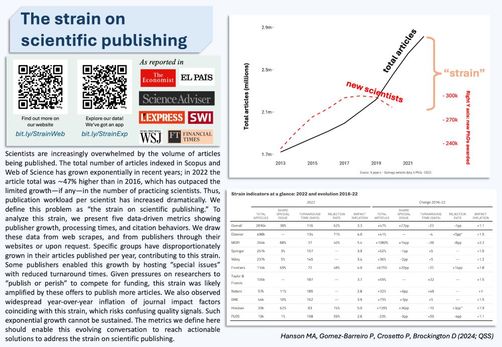
The strain on scientific publishing: we set out to characterise the remarkable growth of the scientific literature in the last few years, in spite of declining growth in total scientists. What is going on?
direct.mit.edu/qss/article/...
A 🧵 1/n
#AcademicSky #PhDchat #ScientificPublishing #SciPub
direct.mit.edu/qss/article/...
A 🧵 1/n
#AcademicSky #PhDchat #ScientificPublishing #SciPub
November 19, 2024 at 12:27 PM
The strain on scientific publishing: we set out to characterise the remarkable growth of the scientific literature in the last few years, in spite of declining growth in total scientists. What is going on?
direct.mit.edu/qss/article/...
A 🧵 1/n
#AcademicSky #PhDchat #ScientificPublishing #SciPub
direct.mit.edu/qss/article/...
A 🧵 1/n
#AcademicSky #PhDchat #ScientificPublishing #SciPub
🚀
A few weeks ago, we launched Pangaea, a benchmark for geospatial (foundation) models!
Focused on dense tasks, Pangea offers a repo to test several models on a global, inclusive and multimodal set of downstream tasks
w/
@lebellig.bsky.social
@yurujia.bsky.social
github.com/yurujaja/pan...
👇
A few weeks ago, we launched Pangaea, a benchmark for geospatial (foundation) models!
Focused on dense tasks, Pangea offers a repo to test several models on a global, inclusive and multimodal set of downstream tasks
w/
@lebellig.bsky.social
@yurujia.bsky.social
github.com/yurujaja/pan...
👇

pangaea-bench/pangaea at main · yurujaja/pangaea-bench
Towards Robust Evaluation for Geospatial Foundation Models - yurujaja/pangaea-bench
github.com
November 22, 2024 at 3:20 PM
🚀
A few weeks ago, we launched Pangaea, a benchmark for geospatial (foundation) models!
Focused on dense tasks, Pangea offers a repo to test several models on a global, inclusive and multimodal set of downstream tasks
w/
@lebellig.bsky.social
@yurujia.bsky.social
github.com/yurujaja/pan...
👇
A few weeks ago, we launched Pangaea, a benchmark for geospatial (foundation) models!
Focused on dense tasks, Pangea offers a repo to test several models on a global, inclusive and multimodal set of downstream tasks
w/
@lebellig.bsky.social
@yurujia.bsky.social
github.com/yurujaja/pan...
👇
Reposted by Valerio Marsocci
I didn't see this already, so I went through my follow list and made a Starter Pack for Women+ in geo & EO - very broadly.
I'm reminded how lopsided the gender divide is still in our field when I get 1 woman follower for every 10 men. It's particularly noticeable right now.
go.bsky.app/Ay1iTTe
I'm reminded how lopsided the gender divide is still in our field when I get 1 woman follower for every 10 men. It's particularly noticeable right now.
go.bsky.app/Ay1iTTe
November 21, 2024 at 9:46 PM
I didn't see this already, so I went through my follow list and made a Starter Pack for Women+ in geo & EO - very broadly.
I'm reminded how lopsided the gender divide is still in our field when I get 1 woman follower for every 10 men. It's particularly noticeable right now.
go.bsky.app/Ay1iTTe
I'm reminded how lopsided the gender divide is still in our field when I get 1 woman follower for every 10 men. It's particularly noticeable right now.
go.bsky.app/Ay1iTTe
Reposted by Valerio Marsocci
Interested in a #phd in remote sensing of forests? Want to come work with me in Cambridge using drones and ground-based Lidar and photogrammetry? Check out this funding opportunity for the EPSRC Sensor CDT
#phd #forests #remotesensing #lidar
🌳🌲🛰️⚡
www.findaphd.com/phds/program...
#phd #forests #remotesensing #lidar
🌳🌲🛰️⚡
www.findaphd.com/phds/program...

FindAPhD : EPSRC Centre for Doctoral Training in Sensor Technologies and Applications in an Uncertain World (Sensor CDT) at University of Cambridge
Apply for a PhD: EPSRC Centre for Doctoral Training in Sensor Technologies and Applications in an Uncertain World (Sensor CDT) at University of Cambridge
www.findaphd.com
November 20, 2024 at 6:30 PM
Interested in a #phd in remote sensing of forests? Want to come work with me in Cambridge using drones and ground-based Lidar and photogrammetry? Check out this funding opportunity for the EPSRC Sensor CDT
#phd #forests #remotesensing #lidar
🌳🌲🛰️⚡
www.findaphd.com/phds/program...
#phd #forests #remotesensing #lidar
🌳🌲🛰️⚡
www.findaphd.com/phds/program...
Reposted by Valerio Marsocci

It's so fun to see so many people here that I used to interact with in other spaces! There's been a lot of updates to the Open Source Geospatial starter pack. Let me know if you want to be added.
go.bsky.app/PGYLmPG
go.bsky.app/PGYLmPG
November 18, 2024 at 12:53 AM
It's so fun to see so many people here that I used to interact with in other spaces! There's been a lot of updates to the Open Source Geospatial starter pack. Let me know if you want to be added.
go.bsky.app/PGYLmPG
go.bsky.app/PGYLmPG
"we have trained more than 50 million neural networks, with more than 150 trillion parameters"
🤯🤯🤯🤯
nianticlabs.com/news/largege...
Btw interesting
🤯🤯🤯🤯
nianticlabs.com/news/largege...
Btw interesting

Building a Large Geospatial Model to Achieve Spatial Intelligence
At Niantic, we are pioneering the concept of a Large Geospatial Model that will use large-scale machine learning to understand a scene and connect it to millions of other scenes globally.
nianticlabs.com
November 21, 2024 at 11:54 AM
"we have trained more than 50 million neural networks, with more than 150 trillion parameters"
🤯🤯🤯🤯
nianticlabs.com/news/largege...
Btw interesting
🤯🤯🤯🤯
nianticlabs.com/news/largege...
Btw interesting
Reposted by Valerio Marsocci
I took the opportunity to make a list of those two starter packs :)
bsky.app/profile/did:...
I already follow too many people and I need lists to organize myself.
bsky.app/profile/did:...
I already follow too many people and I need lists to organize myself.
November 21, 2024 at 8:30 AM
I took the opportunity to make a list of those two starter packs :)
bsky.app/profile/did:...
I already follow too many people and I need lists to organize myself.
bsky.app/profile/did:...
I already follow too many people and I need lists to organize myself.
#37 ALISE
ALISE (ALigned SITS Encoder) is a model for processing irregular and unaligned Satellite Image Time Series (SITS)
⬆️: great sparse data and label handling
⬇️: would be great to extend the domains (geographical and sensor-related)
arxiv.org/abs/2407.08448
ALISE (ALigned SITS Encoder) is a model for processing irregular and unaligned Satellite Image Time Series (SITS)
⬆️: great sparse data and label handling
⬇️: would be great to extend the domains (geographical and sensor-related)
arxiv.org/abs/2407.08448

November 20, 2024 at 12:30 PM
#37 ALISE
ALISE (ALigned SITS Encoder) is a model for processing irregular and unaligned Satellite Image Time Series (SITS)
⬆️: great sparse data and label handling
⬇️: would be great to extend the domains (geographical and sensor-related)
arxiv.org/abs/2407.08448
ALISE (ALigned SITS Encoder) is a model for processing irregular and unaligned Satellite Image Time Series (SITS)
⬆️: great sparse data and label handling
⬇️: would be great to extend the domains (geographical and sensor-related)
arxiv.org/abs/2407.08448
Reposted by Valerio Marsocci

There's now so many awesome #geospatial people here it's hard to keep track! 🤩
Here's a thread of some of my favourite starter packs so far - let me know what I've missed!
🛰️ Earth Observation & remote sensing: go.bsky.app/4PMRhNL
🌏 GIS: go.bsky.app/TJ7qQF6 @milos-makes-maps.bsky.social
(1/n)
Here's a thread of some of my favourite starter packs so far - let me know what I've missed!
🛰️ Earth Observation & remote sensing: go.bsky.app/4PMRhNL
🌏 GIS: go.bsky.app/TJ7qQF6 @milos-makes-maps.bsky.social
(1/n)
November 19, 2024 at 1:22 AM
There's now so many awesome #geospatial people here it's hard to keep track! 🤩
Here's a thread of some of my favourite starter packs so far - let me know what I've missed!
🛰️ Earth Observation & remote sensing: go.bsky.app/4PMRhNL
🌏 GIS: go.bsky.app/TJ7qQF6 @milos-makes-maps.bsky.social
(1/n)
Here's a thread of some of my favourite starter packs so far - let me know what I've missed!
🛰️ Earth Observation & remote sensing: go.bsky.app/4PMRhNL
🌏 GIS: go.bsky.app/TJ7qQF6 @milos-makes-maps.bsky.social
(1/n)
great dataset from great people :)

🚨 The FLAIR dataset has been accepted at NeurIPS2023 in the Benchmark & Dataset track. It contains high-resolution aerial imagery with a ground sample distance of 20 cm and over 20 billion individually labeled pixels for precise land-cover classification. arxiv.org/abs/2310.13336
November 19, 2024 at 1:27 PM
great dataset from great people :)